
Hurricane is a city in Washington County, Utah, United States. Its population was 20,036 as of the 2020 United States Census estimates. The Hurricane valley makes up the easternmost part of the St. George metropolitan area and is near Zion National Park. Hurricane is known for its historic peach and pecan orchards, open space, and green fields.
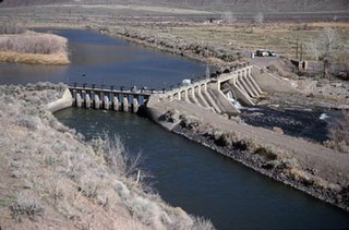
Derby Dam is a diversion dam built from 1903 to 1905 on the Truckee River, located about 20 miles (32 km) east of Reno in Storey and Washoe counties in Nevada, United States. It diverts water into the Truckee Canal that would otherwise enter Pyramid Lake. The canal feeds Lake Lahontan reservoir in the Carson River watershed, where it is used for irrigation.

The Dolores River is a tributary of the Colorado River, approximately 241 miles (388 km) long, in the U.S. states of Colorado and Utah. The river drains a rugged and arid region of the Colorado Plateau west of the San Juan Mountains. Its name derives from the Spanish El Rio de Nuestra Señora de Dolores, River of Our Lady of Sorrows. The river was explored and possibly named by Juan Maria Antonio Rivera during a 1765 expedition from Santa Fe.
The Franklin Canal is an irrigation canal in the Upper Rio Grande Valley near El Paso, Texas. The canal acquires water from the Rio Grande via the American Canal. The canal is 28.4 miles (45.7 km) long with a capacity of 325 cubic feet per second (9.2 m3/s).
The Whitewater Canal, which was built between 1836 and 1847, spanned a distance of 76 miles (122 km) and stretched from Lawrenceburg, Indiana on the Ohio River to Hagerstown, Indiana near the West Fork of the White River.
The Marlette Lake Water System was created to provide water for the silver mining boom in Virginia City, Nevada. These structures are now listed as a National Historic Civil Engineering Landmark by the American Society of Civil Engineers, and are also listed on the National Register of Historic Places. The listed area included two contributing buildings and 12 contributing structures on 135.4 acres (54.8 ha). It has also been known historically as the Virginia and Gold Hill Water Company Water System.
The Central Utah Project is a US federal water project that was authorized for construction under the Colorado River Storage Project Act of April 11, 1956, as a participating project. In general, the Central Utah Project develops a portion of Utah's share of the yield of the Colorado River, as set out in the Colorado River Compact of 1922.

Buffalo Bill Dam is a concrete arch-gravity dam on the Shoshone River in the U.S. state of Wyoming. Originally 325-foot (99 m), it was the tallest dam in the world when it opened in 1910; a 25-foot (7.6 m) extension was added in 1992 in one of numerous changes and improvements to the structure and its support facilities, which include two full time power generators and two seasonal operations added between 1920 and 1994, and a 2.8-mile (4.5 km) irrigation tunnel completed in 1939.
The Carlsbad Irrigation District, also known as Carlsbad Reclamation Project or Irrigation system of the Pecos Irrigation and Improvement Company, is a major early water reclamation project located near Carlsbad in southeastern New Mexico. Begun in the 1880s, it is now managed by the United States Bureau of Reclamation, and provides irrigation water to a large area around Carlsbad, diverted from the Pecos River and the Black River. The late 19th and early 20th-century elements of the project were designated a National Historic Landmark District in 1964.

The Zion – Mount Carmel Highway is a 25-mile (40 km) long road in Washington and Kane counties in southern Utah, United States, that is listed on the National Register of Historic Places and is a National Historic Civil Engineering Landmark.

The historical buildings and structures of Zion National Park represent a variety of buildings, interpretive structures, signs and infrastructure associated with the National Park Service's operations in Zion National Park, Utah. Structures vary in size and scale from the Zion Lodge to road culverts and curbs, nearly all of which were designed using native materials and regional construction techniques in an adapted version of the National Park Service Rustic style. A number of the larger structures were designed by Gilbert Stanley Underwood, while many of the smaller structures were designed or coordinated with the National Park Service Branch of Plans and Designs. The bulk of the historic structures date to the 1920s and 1930s. Most of the structures of the 1930s were built using Civilian Conservation Corps labor.

Central Oregon Irrigation District is a municipal corporation to provide irrigation water for Central Oregon, U.S. The canals serve agricultural and industrial users in the arid lands between Alfalfa, Bend, Redmond, Terrebonne, and Powell Butte. Among its 4,000 or so individual customer accounts, it also provides municipal water to the city of Redmond, neighboring subdivisions, and parks and schools in Bend. The district manages more than 700 miles (1,100 km) of canals serving about 70.3 square miles (182 km2) of lands within a rough area of 280 square miles (730 km2).
The Spanish Fork is a river in southeastern Utah County, Utah, United States.

The Colorado River is a major river of the western United States and northwest Mexico in North America. Its headwaters are in the Rocky Mountains where La Poudre Pass Lake is its source. Located in north central Colorado it flows southwest through the Colorado Plateau country of western Colorado, southeastern Utah and northwestern Arizona where it flows through the Grand Canyon. It turns south near Las Vegas, Nevada, forming the Arizona–Nevada border in Lake Mead and the Arizona–California border a few miles below Davis Dam between Laughlin, Nevada and Needles, California before entering Mexico in the Colorado Desert. Most of its waters are diverted into the Imperial Valley of Southern California. In Mexico its course forms the boundary between Sonora and Baja California before entering the Gulf of California. This article describes most of the major features along the river.

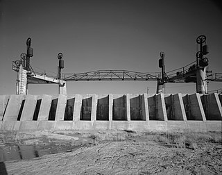
The Grand Valley Diversion Dam is a diversion dam in the De Beque Canyon of the Colorado River, about 15 miles (24 km) northeast of Grand Junction, Colorado in the United States. It is a 14-foot (4.3 m) high, 546-foot (166 m) long concrete roller dam with six gates, which were the first and largest of their kind to be installed in the United States.
The Percha Diversion Dam is a structure built in 1918 on the Rio Grande in New Mexico, United States. It diverts water from the Rio Grande into the Rincon Valley Main Canal, an irrigation canal.
Harry Langley was an architect of the National Park Service. He was born in England. He retired in 1957.

The Carbon Canal is an irrigation canal in the central portion of Utah, United States. The canal was constructed by the Carbon Canal Company between 1907 and 1909 to provide water to agricultural fields west and south of the Price River.

The James Jepson Jr. House is a historic two-story house in Virgin, Utah, United States, that is listed on the National Register of Historic Places, (NRHP).

The Murdock Canal, also known as the Provo Reservoir Canal and the Provo River Aqueduct, is a 23 mile water conveyance system that diverts water from the Provo River and other water storage systems to water users in Utah County. The canal starts at the Murdock Diversion Dam which is located at the mouth of Provo Canyon in Provo, Utah. The canal runs completely underground through Utah Valley and ends at the Jordan Aqueduct in Lehi, Utah. It carries water through the cities of Orem, Lindon, Pleasant Grove, Cedar Hills, American Fork, Highland, and Lehi. The canal is the largest of three primary water conveyance systems in Salt Lake Valley, the other systems being the Jordan Aqueduct and the Salt Lake Aqueduct. The water capacity of the Murdock Canal more than doubles that of either the Jordan Aqueduct or Salt Lake Aqueduct at 612 cfs.


