Hurricane Cindy tornado outbreak

Last updated
Hurricane Cindy (2005) tornado outbreak
Cindy damage at Atlanta Motor Speedway.jpg
Collapsed building at the Atlanta Motor Speedway as a result of an F2 tornado spawned by Cindy.
TypeTornado outbreak
DurationJuly 6–8, 2005
Tornadoes
confirmed
44
Max. rating1 F2 tornado
Duration of
tornado outbreak2
47 hours, 15 minutes
FatalitiesNo fatalities; 1 injury
Damage$76.8 million (2005  USD)
Areas affected Southeastern United States
1Most severe tornado damage; see Fujita scale
2Time from first tornado to last tornado

The Hurricane Cindy (2005) tornado outbreak was a two-day tornado outbreak that was associated with the passage of Hurricane Cindy across the Southern United States starting on July 6, 2005, across the Gulf Coast states of Alabama and Florida as well as Georgia before ending in the Middle Atlantic Coast on early on July 8. The outbreak caused no fatalities and only one injury but was fairly strong, as there were three F2 tornadoes spawned due to Cindy. The hurricane itself killed three people, two in Georgia, one in Alabama. [1] Cindy produced a total of 44 tornadoes across seven states in a two-day span. Just three days after Hurricane Cindy had stuck the Southeastern United States, a much stronger and deadlier storm, Hurricane Dennis, made landfall on the Florida Panhandle on July 10.

Contents

Tornado event

The outbreak began as the remnants of Cindy weakened over Louisiana. As the storm weakened, strong thunderstorms began to develop along the edges of the system in Alabama. The first tornado touched down near Semmes, Alabama at 3:00 a.m. (CST). The tornado caused roof damage to several structures as well as knocking down several trees. [2] Over the next ten hours, several F0 and two F1 tornadoes touched down in Alabama and Florida. Later on July 6, the remnants of Cindy were moving over Alabama and the activity shifted into Georgia. At 8:45 pm (EST), a large tornado touched down near the Atlanta Motor Speedway causing severe damage to the structures in the complex. The tornado then moved into an airfield where several planes and helicopters were damaged. Numerous homes were damaged or destroyed by the tornado as well. The tornado was rated F2 by the NWS. [3] The activity slowed for a short while before picking back up in early afternoon hours on July 7 as the remnants of Cindy moved through Georgia. At 2:10PM (EST) an F2 tornado touched down about seven miles south of Taylorsville, North Carolina where three buildings were damaged a mobile home was destroyed. [4] About an hour later, another F2 tornado touched down in North Carolina. It touched down about four miles north-northeast of Harmony. The tornado damaged several buildings before moving into Yadkin County where an additional 13 buildings were damaged as well as severe crop damage to the tobacco and corn farms. [5] By the nighttime hours, the activity was shifting into Virginia. Before the remnants of Cindy moved out into the Atlantic Ocean, seven F1 tornadoes touched down in Virginia. The outbreak ended early on July 8 as Cindy began to move out over the Atlantic.

Confirmed tornadoes

Confirmed tornadoes by Fujita rating
FUF0F1F2F3F4F5Total
02615300044

July 6 event

List of confirmed tornadoes - Wednesday, July 6, 2005
F# LocationCountyCoord.Time (UTC)Path lengthDamage
Alabama
F0 Semmes area Mobile 30°47′N88°15′W / 30.78°N 88.25°W / 30.78; -88.25 09001 mile (1.6 km)The first tornado of the outbreak touched down around 3:00 a.m. CST near Semmes. Along the tornado's 1 mile (1.6 km) path, a few homes and outbuildings sustained roof damage. Several trees were also knocked down by the tornado. No injuries were reported as a result of the tornado and damages amounted to $50,000. [6]
F0 Chunchula area Mobile 30°55′N88°12′W / 30.92°N 88.2°W / 30.92; -88.2 09531 mile (1.6 km)A brief tornado touched down near Chunchula, knocking down several trees and power lines. No injuries were reported as a result of the tornado and damages amounted to $20,000. [7]
F0 Leroy area Washington 31°30′N87°59′W / 31.5°N 87.98°W / 31.5; -87.98 11200.5 miles (0.8 km)A brief tornado touched down near Leroy, knocking down several trees and power lines. No injuries were reported as a result of the tornado and damages amounted to $15,000. [8]
F0W of Walker Springs Clarke 31°32′N87°53′W / 31.53°N 87.88°W / 31.53; -87.88 11250.5 miles (0.8 km)Brief touchdown, tornado knocked down trees and power lines. Caused $15,000 in damages.
F0 Atmore area Escambia 31°02′N87°30′W / 31.03°N 87.5°W / 31.03; -87.5 12200.5 miles (0.8 km)Brief touchdown, damage was confined to trees. Caused $5,000 in damages.
F0 Watkins Bridge area Covington 31°05′N86°26′W / 31.08°N 86.43°W / 31.08; -86.43 15450.5 miles (0.8 km)Brief touchdown, tornado knocked down trees and power lines. Caused $15,000 in damages.
F0 Lockhart area Covington 31°01′N86°21′W / 31.02°N 86.35°W / 31.02; -86.35 15571 mile (1.6 km)Brief touchdown, tornado knocked down trees and power lines. Caused $15,000 in damages.
F1N of Autaugaville Autauga 32°30′N86°40′W / 32.5°N 86.67°W / 32.5; -86.67 18270.3 miles (0.5 km)Brief touchdown, tornado damaged one outbuilding. Caused $14,000 in damages.
F0NW of Vida Autauga 32°37′N86°41′W / 32.62°N 86.68°W / 32.62; -86.68 18360.2 miles (0.3 km)Brief touchdown, damage was confined to trees. Caused $3,000 in damages.
F0SSW of Cecil Montgomery 32°16′N86°01′W / 32.27°N 86.02°W / 32.27; -86.02 18427.6 miles (12.2 km)Tornado caused damage to a baseball complex. Caused $22,000 in damages.
F0W of Shorter Macon, Elmore 32°24′N85°59′W / 32.4°N 85.98°W / 32.4; -85.98 18555.6 miles (9.0 km)Tornado damaged a few structures. Caused $18,000 in damages.
F0SSW of Tallassee Elmore 32°31′N85°54′W / 32.52°N 85.9°W / 32.52; -85.9 19171.3 miles (2.1 km)Brief touchdown, tornado damaged three homes and one outbuilding. Caused $38,000 in damages.
F1NW of Tuskegee Macon 32°31′N85°48′W / 32.52°N 85.8°W / 32.52; -85.8 19340.1 miles (0.2 km)1 Injury Brief touchdown, tornado completely destroyed an auto body shop. Caused $48,000 in damages.
F0SW of Prattville Autauga 32°25′N86°33′W / 32.42°N 86.55°W / 32.42; -86.55 19560.2 miles (0.3 km)Brief touchdown, tornado damaged a few trees. Caused $2,000 in damages.
F0E of Camp Hill Tallapoosa 32°48′N85°35′W / 32.8°N 85.58°W / 32.8; -85.58 20340.1 miles (0.2 km)Brief touchdown, no damage reported.
F0SW of Lafayette Chambers 32°44′N85°28′W / 32.73°N 85.47°W / 32.73; -85.47 20340.1 miles (0.2 km)Brief touchdown, no damage reported.
F0E of Opelika Lee 32°39′N85°13′W / 32.65°N 85.22°W / 32.65; -85.22 20401.2 miles (1.9 km)Brief touchdown, two mobile homes were damaged. Caused $34,000 in damages.
Florida
F0 Cantonment area Escambia 30°37′N87°20′W / 30.62°N 87.33°W / 30.62; -87.33 11501 mile (1.6 km)Brief touchdown, tornado knocked down several trees and power lines. Caused $20,000 in damages.
F0 Bratt area Escambia 30°58′N87°26′W / 30.97°N 87.43°W / 30.97; -87.43 12110.5 miles (0.8 km)Brief touchdown, tornado knocked down several trees and power lines. Caused $15,000 in damages.
F0 Laurel Hill area Okaloosa 30°58′N87°28′W / 30.97°N 87.47°W / 30.97; -87.47 15551 mile (1.6 km)Brief touchdown, tornado knocked down several trees and power lines. Caused $15,000 in damages.
Georgia
F0SW of Rocky Mount Meriwether 33°09′N84°41′W / 33.15°N 84.68°W / 33.15; -84.68 22300.3 miles (0.5 km)Brief touchdown, two mobile homes and a few vehicles were damaged. Caused $25,000 in damages.
F0N of Haralson Coweta 33°17′N84°34′W / 33.28°N 84.57°W / 33.28; -84.57 01000.1 miles (0.2 km)Brief touchdown, damage was confined to trees. Caused $1,000 in damages.
F0SE of Fayetteville Fayette 33°26′N84°26′W / 33.43°N 84.43°W / 33.43; -84.43 01101 mile (1.6 km)Brief touchdown, hundreds of trees were blown down, twisted, and uprooted along the path of the tornado, many causing damage to dozens of homes and vehicles. Trees fell through the roof of several homes. A couple of businesses in southeast Fayetteville reported extensive damage, with the roof blown off one building on Highway 85 Parkway. Caused $2 million in damages.
F2 Atlanta Motor Speedway to NNE of Lovejoy Henry, Clayton 33°23′N84°19′W / 33.38°N 84.32°W / 33.38; -84.32 01459 miles (14.5 km) See section on this tornado
F0W of McDonough Henry 33°27′N84°10′W / 33.45°N 84.17°W / 33.45; -84.17 01550.5 miles (0.8 km)Brief touchdown, a church and several homes were damaged. Several trees and power lines were also knocked down. Caused $150,000 in damages.
F1NE of McDonough Henry 33°29′N84°06′W / 33.48°N 84.1°W / 33.48; -84.1 01557 miles (11.3 km)Tornado tracked through mostly rural areas and damage was confined to trees and power lines. Caused $25,000 in damages.
Sources:

NCDC Tornado History Project 7/6/05

July 7 event

List of confirmed tornadoes - Thursday, July 7, 2005
F# LocationCountyCoord.Time (UTC)Path lengthDamage
South Carolina
F1W of Anderson Anderson 34°30′N82°48′W / 34.5°N 82.8°W / 34.5; -82.8 06430.5 miles (0.8 km)Brief touchdown, tornado struck a dock where it damaged about twelve sailboats, one of which was thrown 100 yards. Caused $150,000 in damages.
F1NW of Chesnee Spartanburg, Rutherford (NC) 35°11′N81°55′W / 35.18°N 81.92°W / 35.18; -81.92 14510.2 miles (0.3 km)Brief touchdown, one outbuilding had its roof torn off and one mobile home was picked up and dropped 50 to 100 ft from where it once stood, causing severe damage to it. Caused $50,000 in damages.
North Carolina
F2S of Taylorsville Alexander 35°50′N81°10′W / 35.83°N 81.17°W / 35.83; -81.17 17104 miles (6.4 km)Tornado destroyed one mobile home and damaged several homes. Caused $150,000 in damages.
F2NNE of Harmony Iredell, Yadkin 36°00′N80°45′W / 36.0°N 80.75°W / 36.0; -80.75 18108.6 miles (13.8 km)At least 13 structures were damaged or destroyed. In addition to the structural damage, damage to tobacco and corn crops was extensive. Caused $2.4 million in damages.
F1NE of Yadkinville Yadkin 36°09′N80°39′W / 36.15°N 80.65°W / 36.15; -80.65 18411.4 miles (2.3 km)Brief touchdown, damage was confined to trees. No structural damage reported.
F1E of Yadkinville Yadkin 36°08′N80°37′W / 36.13°N 80.62°W / 36.13; -80.62 18531.1 miles (1.8 km)Brief touchdown, damage was confined to trees. No structural damage reported.
F0 Lewisville area Forsyth 36°06′N80°25′W / 36.1°N 80.42°W / 36.1; -80.42 19308 miles (12.9 km)Damage was confined to trees. No structural damage reported.
F0 Ceffo area Person 36°27′N79°03′W / 36.45°N 79.05°W / 36.45; -79.05 19421 mile (1.6 km)Brief touchdown, no damage reported.
F0 Oak Ridge area Guilford 36°11′N79°59′W / 36.18°N 79.98°W / 36.18; -79.98 21205 miles (8.0 km)No damage reported.
F0N of Olivia Harnett 35°23′N79°07′W / 35.38°N 79.12°W / 35.38; -79.12 004012 miles (19.3 km)No damage reported.
Virginia
F1NW of Ararat Patrick 36°38′N80°33′W / 36.63°N 80.55°W / 36.63; -80.55 17220.6 miles (1.0 km)Brief touchdown, no damage reported.
F1N of Alberta Brunswick, Nottoway 36°58′N77°52′W / 36.97°N 77.87°W / 36.97; -77.87 00503.7 miles (6.0 km)Damage confined to trees. Caused $10,000 in damages.
F1 Winterpock area Chesterfield 37°21′N77°44′W / 37.35°N 77.73°W / 37.35; -77.73 02290.5 miles (0.8 km)Brief touchdown, minor damage to one home. Caused $5,000 in damages.
F1E of South Hill Mecklenburg 36°44′N78°07′W / 36.73°N 78.12°W / 36.73; -78.12 02554.5 miles (7.2 km)Tornado caused damage to several structures. Caused $5,000 in damages.
F1S of Beach Chesterfield 37°17′N77°36′W / 37.28°N 77.6°W / 37.28; -77.6 04150.5 miles (0.8 km)Brief touchdown, damage was mainly confined to a small forested area. Caused $3,000 in damages.
F1 Varina area Henrico 37°28′N77°24′W / 37.47°N 77.4°W / 37.47; -77.4 05150.1 miles (0.2 km)Brief touchdown, tornado blew the roof off an industrial barn. Caused $5,000 in damages
Sources:

NCDC Tornado History Project 7/7/05

July 8 event

List of confirmed tornadoes - Friday, July 8, 2005
F# LocationCountyCoord.Time (UTC)Path lengthDamage
Virginia
F1N of Capron Southampton 36°43′N77°12′W / 36.72°N 77.2°W / 36.72; -77.2 06201 mile (1.6 km)Brief touchdown, tornado caused minor damage. Caused $2,000 in damages.
F1 Saluda area Middlesex 37°36′N76°36′W / 37.6°N 76.6°W / 37.6; -76.6 07153 miles (4.8 km)Tornado blew the roof off one home. Caused $5,000 in damages.
Sources:

NCDC Tornado History Project 7/8/05

Atlanta Motor Speedway tornado

Atlanta Motor Speedway, Georgia
F2 tornado
Max. rating1 F2 tornado
Fatalities0
Damage$71.5 million (2005 USD)
1Most severe tornado damage; see Fujita scale

On July 6 at 8:45 pm (EST), a large, half-mile-wide tornado touched down near the Atlanta Motor Speedway. The tornado was estimated to have had winds of 120 mph as it tore through the complex. [3] Every building had sustained at least minor damage and some that were damaged beyond repair. On some of the condominiums, the roof had caved in. Most structures had their windows blown out. The five-story scoreboard was blown down as well. The track was not damaged, however, debris was littered all over it. [9] The tornado continued on its path of destruction towards the Tara Field Airport, west of the speedway. There, eleven planes and five vintage helicopters were damaged. The tornado then moved towards the Edgar Blalock Raw Water Reservation. At this point, the tornado had already been weakening and shrinking. The tornado turned to the northwest and crossed into Clayton County. The tornado lifted shortly after at around 9:04 p.m. (EST).

Damage from the tornado was extensive. About $40 million in damages was caused to the Speedway as many buildings needed to be torn down and rebuilt. [9] Nearby the airport, a Chevron Auto service station was destroyed and at least 60 homes were severely damaged and over 200 others damaged along the tornados' nine-mile track. Power to most of Henry County was out due to the damage. [3]

Following the tornado, all races scheduled to take place for several weeks were cancelled; the first race after the repair work was finished was to take place on October 30. [10]

In all, the tornado caused $71.5 million in damages and despite all the devastation, no one was injured by the tornado.

See also

Related Research Articles

<span class="mw-page-title-main">Hurricane Edith (1971)</span> Category 5 Atlantic hurricane

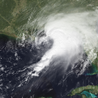
Hurricane Edith was the strongest hurricane to form during the 1971 Atlantic hurricane season and the southernmost landfalling Category 5 hurricane on record in the Atlantic at the time. Edith developed from a tropical wave on September 5 and quickly strengthened into a hurricane in the Caribbean Sea. Edith rapidly intensified on September 9 and made landfall on Cape Gracias a Dios as a Category 5 hurricane on the Saffir-Simpson Hurricane Scale. Being a category 5 hurricane, Edith peaked at only 943 mbar (hPa), making Edith the least intense category 5 Atlantic hurricane on record. It quickly lost intensity over Central America and after briefly entering the Gulf of Honduras it crossed the Yucatán Peninsula in Mexico. After moving across the Gulf of Mexico a trough turned the storm to the northeast and Edith, after having restrengthened while accelerating towards the coast, made landfall on Louisiana with winds of 105 mph (169 km/h) on September 16. Edith steadily weakened over land and dissipated over Georgia on September 18.

<span class="mw-page-title-main">Tropical Storm Tammy (2005)</span> Atlantic tropical storm in 2005

Tropical Storm Tammy was a short-lived tropical storm during October in the 2005 Atlantic hurricane season which caused minor damage to the southeastern United States. More significant, however, were its remnants, which contributed to the Northeast U.S. flooding of October 2005.

<span class="mw-page-title-main">Hurricane Cindy (2005)</span> Category 1 hurricane in 2005

Hurricane Cindy was a tropical cyclone that briefly reached minimal hurricane strength in the Gulf of Mexico during July in the 2005 Atlantic hurricane season and made landfall in Louisiana. It was the third named storm and first hurricane of the season. Cindy was originally thought to have been a tropical storm at peak strength, but was upgraded to a Category 1 hurricane in the post-season analysis. Cindy formed on July 3 just east of the Yucatán Peninsula in the Caribbean Sea. The depression soon made landfall on the peninsula and weakened before reemerging in the Gulf of Mexico on July 4. The storm strengthened as it moved north becoming a hurricane just before making landfall near Grand Isle, Louisiana, on July 5. The storm weakened as it moved overland and became extratropical on July 7.

<span class="mw-page-title-main">Hurricane Danny (1997)</span> Category 1 Atlantic hurricane

Hurricane Danny was the only hurricane to make landfall in the United States during the 1997 Atlantic hurricane season, and the second hurricane and fourth tropical storm of the season. The system became the earliest-formed fifth tropical or subtropical storm of the Atlantic season in history when it attained tropical storm strength on July 17, and held that record until the 2005 Atlantic hurricane season when Tropical Storm Emily broke that record by several days. Like the previous four tropical or subtropical cyclones of the season, Danny had a non-tropical origin, after a trough spawned convection that entered the warm waters of the Gulf of Mexico. Danny was guided northeast through the Gulf of Mexico by two high pressure areas, a rare occurrence in the middle of July. After making landfall on the Gulf Coast, Danny tracked across the southeastern United States and ultimately affected parts of New England with rain and wind.

<span class="mw-page-title-main">Hurricane Earl (1998)</span> Category 2 Atlantic hurricane in 1998

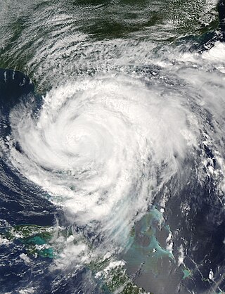
Hurricane Earl was an atypical, disorganized, and short-lived Category 2 hurricane that caused moderate damage throughout the Southeast United States. It formed out of a poorly organized tropical disturbance over the southwest Gulf of Mexico late on August 31, 1998. Tracking towards the northeast, the storm quickly intensified into a hurricane on September 2 and made landfall early the next day near Panama City, Florida. Rapidly tracking towards Atlantic Canada, the extratropical remnants of Earl significantly intensified before passing over Newfoundland on September 6. The remnants were absorbed by former Hurricane Danielle two days later.

<span class="mw-page-title-main">Hurricane Katrina tornado outbreak</span> August 2005 tornado outbreak in southeastern United States

Accompanying Hurricane Katrina's catastrophic coastal impacts was a moderate tornado outbreak spawned by the cyclone's outer bands. The event spanned August 26–31, 2005, with 57 tornadoes touching down across 8 states. One person died and numerous communities suffered damage of varying degrees from central Mississippi to Pennsylvania, with Georgia sustaining record monetary damage for the month of August. Due to extreme devastation in coastal areas of Louisiana and Mississippi, multiple tornadoes may have been overlooked—overshadowed by the effects of storm surge and large-scale wind—and thus the full extent of the hurricane's tornado outbreak is uncertain. Furthermore, an indeterminate number of waterspouts likely formed throughout the life cycle of Hurricane Katrina.

<span class="mw-page-title-main">Tropical Storm Bill (2003)</span> Atlantic tropical cyclone

Tropical Storm Bill was a tropical storm that affected the Gulf Coast of the United States in the summer of 2003. The second storm of the 2003 Atlantic hurricane season, Bill developed from a tropical wave on June 29 to the north of the Yucatán Peninsula. It slowly organized as it moved northward, and reached a peak of 60 miles per hour (97 km/h) shortly before making landfall in south-central Louisiana. Bill quickly weakened over land, and as it accelerated to the northeast, moisture from the storm, combined with cold air from an approaching cold front, produced an outbreak of 34 tornadoes. Bill became extratropical on July 2, and was absorbed by the cold front later that day.

<span class="mw-page-title-main">Tornadoes of 2005</span>

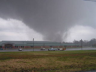
This page documents notable tornadoes and tornado outbreaks worldwide in 2005. Strong and destructive tornadoes form most frequently in the United States, Bangladesh, Argentina, Brazil and Eastern India, but they can occur almost anywhere under the right conditions. Tornadoes also develop occasionally in southern Canada during the Northern Hemisphere's summer and somewhat regularly at other times of the year across Europe, Asia, and Australia. Tornadic events are often accompanied with other forms of severe weather, including strong thunderstorms, strong winds, and hail.

<span class="mw-page-title-main">Tornadoes of 2004</span>

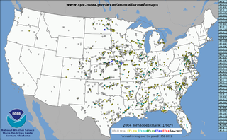
This page documents notable tornadoes and tornado outbreaks worldwide in 2004. Strong and destructive tornadoes form most frequently in the United States, Bangladesh, and Eastern India, but they can occur almost anywhere under the right conditions. Tornadoes also develop occasionally in southern Canada during the Northern Hemisphere's summer and somewhat regularly at other times of the year across Europe, Asia, and Australia. Tornadic events are often accompanied with other forms of severe weather, including strong thunderstorms, strong winds, and hail.

<span class="mw-page-title-main">Tornadoes of 2001</span>

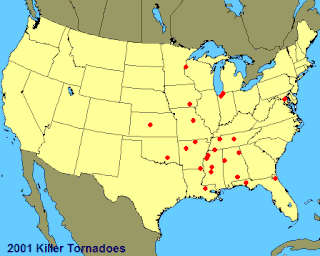
This page documents notable tornadoes and tornado outbreaks worldwide in 2001. Strong and destructive tornadoes form most frequently in the United States, Bangladesh, and Eastern India, but they can occur almost anywhere under the right conditions. Tornadoes also develop occasionally in southern Canada during the Northern Hemisphere's summer and somewhat regularly at other times of the year across Europe, Asia, and Australia. Tornadic events are often accompanied with other forms of severe weather, including strong thunderstorms, strong winds, and hail.

<span class="mw-page-title-main">Hurricane Ivan tornado outbreak</span>

The Hurricane Ivan tornado outbreak was a three-day tornado outbreak that was associated with the passage of Hurricane Ivan across the Southern United States starting on September 15, 2004, across the Gulf Coast states of Alabama and Florida as well as southern Georgia before ending in the Middle Atlantic Coast on September 18.

<span class="mw-page-title-main">Hurricane Frances tornado outbreak</span>

The Hurricane Frances tornado outbreak was a widespread tornado outbreak associated with Hurricane Frances that came ashore on eastern Florida on September 4–5, 2004. Outer bands from the hurricane and its remnants, when it moved across the Appalachian Mountains, produced one of the largest tornado outbreaks ever spawned by a tropical cyclone in the United States in terms of number of tornadoes confirmed since records were kept in 1950. In addition, it was the largest tornado outbreak in South Carolina history, with nearly half of the tornadoes in that state.

<span class="mw-page-title-main">Hurricane Georges tornado outbreak</span>

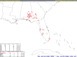
The 1998 Hurricane Georges tornado outbreak was a six-day tornado outbreak associated with the passage of Hurricane Georges in the Southeast United States. Most of the tornadoes produced by the storm formed in the outer bands of the storm and were relatively weak; however, one F2 tornado touched down in Florida. The outbreak produced 47 tornadoes—20 in Alabama, 17 in Florida and 10 in Georgia—and was the most extensive tornado event in Florida history, with touchdowns reported the entire length of the state.

<span class="mw-page-title-main">Tornadoes of 1996</span>

This page documents the tornadoes and tornado outbreaks of 1996, primarily in the United States. Most tornadoes form in the U.S., although some events may take place internationally. Tornado statistics for older years like this often appear significantly lower than modern years due to fewer reports or confirmed tornadoes, however by the 1990s tornado statistics were coming closer to the numbers we see today.

<span class="mw-page-title-main">Tornadoes of 1954</span>

This page documents the tornadoes and tornado outbreaks of 1954, primarily in the United States. Most tornadoes form in the U.S., although some events may take place internationally. Tornado statistics for older years like this often appear significantly lower than modern years due to fewer reports or confirmed tornadoes.

<span class="mw-page-title-main">Tornado outbreak sequence of December 1–6, 1953</span> Weather event affecting Southeastern United States

The first six days of December 1953 produced a destructive and deadly tornado outbreak sequence across the Southern United States. There were 19 confirmed tornadoes, including a violent F4 tornado that hit the northwest side of Alexandria, Louisiana and even more violent F5 tornado that hit Vicksburg, Mississippi. In all, the tornadoes killed 49 people, injured 404 others, and caused $45,709 million in damage. The death toll made this deadliest December tornado outbreak ever recorded and it would not be surpassed until 2021. This was also the last of the series of deadly and catastrophic tornado outbreaks to strike the US in 1953.

A destructive and deadly tornado outbreak tore through Eastern Alabama and Western Georgia during the afternoon of December 5, 1954. A total of 14 tornadoes were confirmed, 10 of which were significant (F2+), including one that hit Metro Atlanta. Two people were killed, 125 others were injured, and damages total $2.710 million.

<span class="mw-page-title-main">Hurricane Carla tornado outbreak</span> Weather event

Hurricane Carla triggered a destructive and deadly outbreak of 21 tornadoes in Alabama, Louisiana, Texas, Arkansas, and Michigan that occurred from September 10–13, 1961. A total of 11 tornadoes touched down in Louisiana, and eight more in Texas. The strongest tornado of the outbreak was a 1 mile (1.6 km) long, 100 yards (91 m) wide F4 tornado that moved across Galveston Island in the early morning hours of Tuesday, September 12, 1961, killing eight people. This was the first of only two known violent tornadoes ever spawned by a hurricane with the other one happening during Hurricane Hilda in 1964. By the time it was over, the outbreak had killed 14 people, injured 337 others, and caused over $3.461 million in damage.

References

  1. National Hurricane Center. "Tropical Cyclone Report: Hurricane Cindy" (PDF). NOAA. Archived (PDF) from the original on 25 June 2008. Retrieved June 22, 2008.
  2. "NCDC: Event Details". Archived from the original on 2008-10-12. Retrieved 2008-06-22.
  3. 1 2 3 National Weather Service. "NCDC Event Details: Atlanta Motor Speedway Tornado". NOAA. Archived from the original on October 12, 2008. Retrieved June 22, 2008.
  4. "NCDC: Event Details". Archived from the original on 2008-10-12. Retrieved 2008-06-22.
  5. NCDC: Event Details Archived October 12, 2008, at the Wayback Machine
  6. "NCDC Event Report: Alabama Tornado". National Climatic Data Center. 2005. Archived from the original on October 12, 2008. Retrieved March 14, 2009.
  7. "NCDC Event Report: Alabama Tornado". National Climatic Data Center. 2005. Retrieved March 14, 2009.
  8. "NCDC Event Report: Alabama Tornado". National Climatic Data Center. 2005. Retrieved March 14, 2009.
  9. 1 2 NBC Sports. "Atlanta Speedway badly damaged by tornado". NBC. Archived from the original on October 12, 2008. Retrieved June 22, 2008.
  10. "Tornado Shreds Atlanta Motor Speedway". Fox News. Associated Press. July 8, 2005. Archived from the original on December 2, 2008. Retrieved March 14, 2009.