Hurricane Hanna

Last updated

Hurricane Hanna
Category 1 hurricane (SSHWS/NWS)
Hanna 2008-09-01.jpg
Hurricane Hanna at peak intensity over the Turks and Caicos Islands on September 1
FormedAugust 28, 2008
DissipatedSeptember 12, 2008
(Extratropical after September 7)
Highest winds 1-minute sustained:85 mph (140 km/h)
Lowest pressure977 mbar (hPa); 28.85 inHg
Fatalities~537 total
Damage$160 million (2008 USD)
Areas affected Puerto Rico, Turks and Caicos Islands, Bahamas, Hispaniola, Eastern Seaboard, Atlantic Canada
Part of the 2008 Atlantic hurricane season

Hurricane Hanna was a moderate but deadly tropical cyclone that caused extensive damage across the Western Atlantic, particularly in the Turks and Caicos Islands and the East Coast of the United States. The eighth named storm and fourth hurricane of the 2008 Atlantic hurricane season. It formed east-northeast of the northern Leeward Islands on August 28. Initially, the storm struggled to intensify due to moderate wind shear as it moved westwards towards the Bahamas. By August 31, Hanna had drifted southwards and began intensifying while over the Bahamas; it attained its peak intensity as a Category 1 hurricane while over the Turks and Caicos Islands. Due to the outflow of the nearby Hurricane Gustav, Hanna weakened back into a tropical storm the next day as it began to drift northwestwards towards the Southeastern United States. The storm struck Myrtle Beach, South Carolina, before moving up the Eastern Seaboard to become an extratropical cyclone as it moved by New England into Atlantic Canada early on September 7. The system raced across the North Atlantic, sweeping west of Great Britain on September 10 before turning north and becoming absorbed by a stronger extratropical cyclone between Iceland and Greenland late on September 12.

Contents

At least 537 deaths were reported (the final death toll will likely never be known), mostly due to flooding in the northern part of Haiti. Hanna also caused $160 million in damages to the U.S, but the exact damage in Haiti is unknown. Despite the high number of deaths caused by the hurricane, the name Hanna was not retired.

Meteorological history

Map plotting the track and the intensity of the storm, according to the Saffir-Simpson scale Hanna 2008 track.png
Map plotting the track and the intensity of the storm, according to the Saffir–Simpson scale

During late August 2008, a tropical wave emerged off the coast of Africa and tracked westward across the Atlantic Ocean. After several days, an associated area of low pressure gained deep convection and organization. On August 28, while to the east-northeast of the northern Leeward Islands, the low formed into Tropical Depression Eight. Later that day, it attained tropical storm status, and as such was named Hanna by the National Hurricane Center. [1] At the time, the low-level center of circulation was partially exposed on the western edge of the convection, indicating westerly wind shear. [2]

Tracking westward primarily under the steering current of a large ridge to the north, the convective pattern began to redevelop late on August 28. Since forecast, models predicted the storm would weaken and move southwestward due to outflow associated with nearby Hurricane Gustav. Despite this, the storm began entering a favorable environment, and was forecast to intensify. [3] An upper-level low that had been producing wind shear moved away from the system, though light shear continued. At the same time, the low-level center once again became separated from the convection, which was primarily confined to a cyclonic banding feature in the eastern half of the circulation. [4] It remained weak as it moved erratically westward while east of the Bahamas on August 30. Due to the influence of Hurricane Gustav's large circulation, Hanna suddenly took a sharp southerly turn and slowed down to drift while located to the north of the Turks and Caicos Islands. [5] On September 1, as Hanna drifted to the south-southwest, convection increased and the storm began to intensify. [6] Later that day around 1:30 pm EDT, an Air Force Reconnaissance Aircraft found winds within Hanna supportive of hurricane strength, and the National Hurricane Center upgraded Hanna to a hurricane. [7] Early on September 2, strong wind shear in association with Hurricane Gustav began to affect Hanna and the storm was downgraded to a tropical storm on September 3. Hanna then sharply turned back northward, causing additional damage in Haiti. Over the course of the next three days, Hanna slighted northwestward towards the Bahamas, before turning abruptly north. By September 5th, Hanna turned westward towards the Carolinas. [8] Early on September 6, 2008, Hanna made landfall near the South Carolina-North Carolina border. [9] The system became an extratropical cyclone as it moved into Atlantic Canada early on September 7 and raced across the North Atlantic, sweeping west of Great Britain on September 10 before turning north and becoming absorbed by a stronger extratropical cyclone between Iceland and Greenland late on September 12. [10]

Preparations

Greater Antilles

Hanna just north of the Lesser Antilles with its surface circulation displaced to the west of its convection. Hanna 29 August 2008.jpg
Hanna just north of the Lesser Antilles with its surface circulation displaced to the west of its convection.

The National Hurricane Center and various governments issued multiple tropical cyclone warnings and watches due to the threat of Hanna. In southeastern Bahamas and the Turks and Caicos Islands, a tropical storm watch was posted at 15:00 UTC on August 30. Around 09:00 UTC the next day, the tropical storm watch was upgraded to a tropical storm warning in the Turks and Caicos Islands; six hours later, the watch was also increased in the southeastern Bahamas. Another tropical storm watch was issued for the central Bahamas at 15:00 UTC on August 31 and was upgraded to a tropical storm warning about six hours later. A hurricane watch was put into effect for the central Bahamas on September 1 at 15:00 UTC. Three hours later, all tropical storm warnings were upgraded to hurricane warnings, while the hurricane watch in the central Bahamas was discontinued. [1]

Early on September 3, a hurricane watch was issued for the northwestern Bahamas and switched to a hurricane warning several hours later. That same day, the hurricane warning in effect for the central and southeastern Bahamas, as well as the Turks and Caicos Islands, was downgraded to a tropical storm warning. At 03:00 UTC on September 4, the hurricane warning for the northwestern Bahamas was also decreased to a tropical storm warning. About nine hours later, the tropical storm warning was cancelled for the southeastern Bahamas and the Turks and Caicos Islands. The remaining portion of the tropical storm warning, for the central and northwestern Bahamas, was discontinued late on September 5. [1]

The Bahamas

In Turks and Caicos Islands, streets were cleared, while schools and airports were closed as Hanna approached. [11] On Providenciales, 800 people stayed in shelters. The storm was predicted to bring up to 12 inches (300 mm) of precipitation to the Turks and Caicos and southeastern Bahamas. In the Bahamas, National Emergency Operations Centre was used to provide advice to the public. All national medical facilities were inspected and equipped with necessary supplies and equipment. About 139 people and 20 others stayed in shelters on Acklins and Long Cay, respectively. [12]

Hispaniola

Along the northern coast of Haiti, a tropical storm warning was issued from Môle-Saint-Nicolas to the border with Dominican Republic at 15:00 UTC on September 2. Six hours later, the warning area was extended to Port-au-Prince. Simultaneously, another tropical storm warning was issued along the north coast of Dominican Republic from Puerto Plata westward to Bahia de Manzanillo. By 03:00 UTC on September 4, the tropical storm warnings in both countries were discontinued. [1]

United States and Canada

Tropical Storm Hanna approaching South Carolina on September 6 Tropical Storm Hanna over the East Coast (Sept. 6, 2008 at 16-05 UTC).jpg
Tropical Storm Hanna approaching South Carolina on September 6

At 09:00 UTC on September 4, a tropical storm watch was issued from the mouth of the Altamaha River in Georgia to Edisto Beach, South Carolina. Simultaneously, a hurricane watch was posted from Edisto Beach to Surf City in North Carolina. The hurricane watch was extended further north to Ocracoke Inlet, North Carolina, at 15:00 UTC on September 4. Three hours later, a tropical storm warning became in effect from the mouth of the Savannah River in Georgia to the North CarolinaVirginia state line, which included Albemarle and Pamlico sounds; the hurricane watch was extended to the Currituck Beach Light in North Carolina. Also at 21:00 UTC on September 4, a tropical storm watch was issued from the North CarolinaVirginia state line to the Great Egg Harbor Bay in New Jersey and included the tidal portions of the Potomac River as well as Chesapeake Bay, Washington, D.C., and Delaware Bay. [1] On September 5 at 09:00 UTC, the tropical storm warning in effect from the mouth of the Altamaha River to the Currituck Beach Light was extended northward to Chincoteague, Virginia and included a portion of Chesapeake Bay. [1]

The tropical storm watch from the North CarolinaVirginia state line to Great Egg Harbor was northward extended to Sandy Hook, New Jersey, while the portion south of Chincoteague was discontinued at 0:900 UTC on September 5. That tropical storm watch was upgraded to a tropical storm warning at 15:00 UTC on September 5. Simultaneously, the tropical storm watch issued at 09:00 UTC was extended further north to Watch Hill, Rhode Island. Around 21:00 UTC on September 5, the tropical storm watch, which stretched from Sandy Hook to Watch Hill, was again expanded to the mouth of the Merrimack River in Massachusetts. Early the next day, the tropical storm warning south of Edisto Beach was discontinued, while the hurricane watch south of the mouth of the Santee River in South Carolina was also canceled. At 03:00 UTC on September 6, a portion of the tropical storm watch from Sandy Hook to Watch Hill was upgraded to a tropical storm warning and further to the Merrimack River about six hours later. Thereafter, the tropical cyclone warnings and watches were gradually discontinued, until none remained at 09:00 UTC on September 7. [1]

Hanna caused rainfall as far inland as Huntington, West Virginia TS Hanna Huntington, WV.jpg
Hanna caused rainfall as far inland as Huntington, West Virginia

From Florida to New York, Amtrak canceled some train routes that run through the southeast United States. [13] In Florida, Governor Charlie Crist declared a state of emergency as Hanna initially appeared to be a threat. Governor Crist declined to attend the Republican National Convention in Saint Paul, Minnesota and remarked that, "We've got a lot coming at us, and I think it's important to be here ... I haven't been in communication with anyone at the RNC ... Our focus needs to stay on these storms." [14] The National Aeronautics and Space Administration (NASA) also announced that the movement of the Space Shuttle Atlantis to the launchpad for Flight STS-125 from the Kennedy Space Center would be pushed up a day due to the threat of Hanna. [15]

On September 5, rural water associations in the Carolinas and neighboring states prepared staff and equipment to respond to emergencies. Associations activated their mutual aid networks, preparing for the landfall of Hanna and Hurricane Ike while still providing assistance to areas impacted by Hurricane Gustav. [16] In Wilmington, North Carolina, the University of North Carolina at Wilmington canceled all classes and activities for Friday, September 5, and Saturday, September 6, in preparation for the storm, and issued an advised voluntary evacuation. UNCW officially closed at noon on Friday, and reopened at noon on Saturday, after the storm had passed. Specifically Wagoner Dining Hall, Randall Library, and the Student Recreation Center were reopened to students. Classes resumed regular schedules on Monday, September 8.

Hanna's effects in New York City Hurricane Hanna 2008 NYC.jpg
Hanna's effects in New York City

Christopher Newport University in Newport News, Virginia, canceled all class and activities on Friday and Saturday and issued a mandatory evacuation due to fears of a power outage. The College of William & Mary and Old Dominion University nearby had not made any similar plans. Old Dominion University and nearby neighboring school Norfolk State University did cancel classes for both Friday afternoon, and Saturday, due to the possibilities of heavy rain and wind. [17] [18] Two other Hampton Roads schools, Regent University and Virginia Wesleyan College, did not close on Friday, but Regent closed completely on Saturday, [19] while Virginia Wesleyan canceled classes on Saturday but otherwise remained open. [20]

On Friday, September 5, NASCAR announced that they would postpone the NASCAR Nationwide Series Emerson Radio 250 (scheduled to be run that evening) and the next day's NASCAR Sprint Cup Series Chevy Rock and Roll 400 until Sunday afternoon after Hanna had moved north of Virginia. Both races were held at the Richmond International Raceway in Henrico County, Virginia. With a delay in the storm during the day on September 6, the US Open tennis tournament went on, but was eventually canceled as the rains came. Nearby at Shea Stadium, the baseball game between the New York Mets and Philadelphia Phillies was cancelled in advance of the storm, rescheduled as a day-night doubleheader on September 7.

Power companies on Long Island were preparing for a minimal hurricane and the first real test of New York's readiness for a strong storm impacting the region. In Nassau County, phone calls were attempted to volunteer fire departments, but simultaneously calls were being made to 193,000 residences about the West Nile virus, slowing down phone connections. Over 800 workers were on standby in case anything were to happen due to the storm. [21]

In Canada, the Emergency Measures Organization of the Canadian province of New Brunswick issued a warning on September 5 to expect "significant rainfall" and "localized flooding" on September 7 and September 8. [22]

Impact

Wettest tropical cyclones and their remnants in Haiti
Highest-known totals
PrecipitationStormLocationRef.
Rankmmin
11,447.857.00 Flora 1963 Miragoâne [23]
2654.825.78 Noel 2007 Camp Perrin [24]
3604.523.80 Matthew 2016 Anse-á-Veau [25]
4410.016.14 Lili 2002 Camp Perrin [26]
5323.012.72 Hanna 2008 Camp Perrin [27]
6273.010.75 Gustav 2008 Camp Perrin [28]
765.02.56 Fox 1952 Ouanaminthe [29]
Deaths by country
Haiti 529
Dominican Republic 1
United States 7
Total537

The storm brought heavy rainfall and flooding throughout its path. Particularly hard hit was Haiti, as the ground was already saturated by Tropical Storm Fay and Hurricane Gustav. [1] A deadly flooding event ensued, with 529 fatalities confirmed, most of which were in the Gonaïves area. [30] One person drowned in the neighboring country of Dominican Republic. [31] Mostly minor damage occurred in the Bahamas. [1] Along the coast of the Southeastern United States, three people drowned offshore Florida due to rip currents. [15] [32] Several states along the East Coast of the United States from South Carolina to Maine reported flooding. [33] Throughout the country, there were seven deaths and approximately $160 million in damage.

U.S. Virgin Islands and Puerto Rico

Rainfall from Hanna over Puerto Rico Hanna 2008 Puerto Rico rainfall.gif
Rainfall from Hanna over Puerto Rico

In the United States Virgin Islands, the outer bands of Hanna dropped locally heavy rainfall on some islands, particularly at the Cyril E. King Airport on Saint Thomas. Additionally, a National Weather Service observed reported 1.7 inches (43 mm) of precipitation over a 24-hour period. [34]

Some areas of northeastern Puerto Rico observed 10–12 inches (250–300 mm) of rain in only 24 hours. As a result, many rivers exceeded their banks and several mudslides were reported. A number of streets were inundated and later closed. The Westin Rio Mar Golf Club course in Río Grande was also flooded. On the western side of the island in Añasco, residents fled their homes for shelters. [33]

The Bahamas

Widespread rain and strong winds were reported in the Bahamas and Turks and Caicos Islands as a result of Hanna. Only relatively minor damage and no fatalities were reported in either area. However, damage assessments were limited to the passage of Hurricane Ike less than a week later. Winds caused roof damage to some homes. Storm surge flooded the Providenciales and Five Cays. Many roads were inundated and suffered damage, including to a recently completed causeway linking North and Middle Caicos Islands. There were also reports of boats in and near the Caicos Islands that were washed ashore or sunk during the storm. [1]

Hispaniola

Haiti, already rain-saturated by Fay and Gustav, was hit hard by flooding and mudslides from several days of heavy rainfall, particularly in the city of Gonaïves which also suffered catastrophic damage in 2004 from Hurricane Jeanne. Nearly the entire city was flooded with water as high as 2 meters (6.6 feet) deep, and some people had to be rescued on their roofs. [35] In Les Cayes, a hospital had to be evacuated as it was swamped by flood water. At least 5,000 people there were moved to public shelters due to the flooding. [36] The United Nations have ordered relief convoys to the hard-hit region, including rafts to help rescue victims. [37] As of late on September 4, Haiti's government said the death toll from Tropical Storm Hanna had increased to at least 529, with most of the deaths coming in the flooded port city of Gonaïves, where the destruction was described as "catastrophic" and 495 bodies were discovered as of late on September 5. [30] [38] Haitian authorities said the tally could grow once officials are able to make their way through Gonaïves. "The assessment is only partial, because it is impossible to enter the city for the moment", Gonaïves Mayor Stephen Moise said. [39] In the aftermath of Hanna at least 48,000 from the Gonaïves areas went to shelters. Some people slept on the roofs of their house to protect them from looters. The catastrophe left many homeless and begging for food and clothes. Others left for the mountains hoping to wait out the next storms on the horizon. [40] Haitians became aggravated at the lack of assistance in the wake of Hanna, with very little aid coming from international organizations. Bridges north and south of Gonaïves collapsed, with roads in the vicinity of the area transformed into swamps. [40]

Over a week after Hanna brushed the Dominican Republic, the body of a fisherman who drowned in the storm was found in the Atlantic just off the northern coast. [31]

United States

Minor street flooding in Westchester County, New York TS Hanna Westchester New York Flooding.JPG
Minor street flooding in Westchester County, New York
Flood damage in Eno River State Park, North Carolina Hanna Damage Durham.jpg
Flood damage in Eno River State Park, North Carolina

While in the Atlantic near the Bahamas, high surf and rip currents were produced by Hanna off the Southeast U.S. coast. A 14-year-old boy drowned at John U. Lloyd Beach State Park near Hollywood, Florida, as a result of the rip currents brought up by the distant Hanna. [32] Two more deaths were reported off the coast of Fort Lauderdale, Florida, as they drowned in the high seas. [15] Because of the threat of a medium-term impact on the state and anticipated track of the storm, the governors of Florida, [37] Virginia, North Carolina, [41] and Maryland [42] declared a state of emergency for their states and commonwealth. Washington, D.C., along with numerous other state and municipalities activated their Emergency Operations Centers in preparation for the storm. [43] [44] [45] Hanna may have also spawned tornado(s) near Greenville, North Carolina and Allentown, Pennsylvania. [46] After landfall in the Carolinas, Hanna was at its strongest when its center was just south of New York City at 11 pm EDT on September 6, when 60 mph (95 km/h) winds were recorded at the center; however, because most winds past the center were more gusty than sustained, most damage in the area was related to the rain. A 38-year-old man drowned due to rip currents in New Jersey as Hanna approached. [47] Hanna knocked out power to about 32,000 people on Long Island as it quickly passed through on September 6. [21]

See also

Related Research Articles

Hurricane Hortense Category 4 Atlantic hurricane in 1996

Hurricane Hortense was the first tropical cyclone to make landfall in Guadeloupe and Puerto Rico since Hurricane Hugo in 1989, and the second most intense hurricane during the 1996 Atlantic hurricane season. The eighth tropical cyclone, eighth named storm, and sixth hurricane of the season. Hortense developed on September 3 from a tropical wave in the central Atlantic Ocean.

Hurricane Frances Category 4 Atlantic hurricane in 2004

Hurricane Frances was the second most intense tropical cyclone in the Atlantic during 2004 and proved to be very destructive in Florida. It was the sixth named storm, the fourth hurricane, and the third major hurricane of the 2004 Atlantic hurricane season. The system crossed the open Atlantic in late August, moving to the north of the Lesser Antilles while strengthening. Its outer bands struck Puerto Rico and the British Virgin Islands while passing north of the Caribbean Sea. The storm's maximum sustained wind peaked at 145 mph (233 km/h), achieving Category 4 on the Saffir-Simpson Hurricane Scale. As the system's forward motion slowed, the eye passed over San Salvador Island and very close to Cat Island in the Bahamas. Frances was the first hurricane to impact the entire Bahamian archipelago since 1928 and almost completely destroyed their agricultural economy.

Hurricane Jeanne Category 3 Atlantic hurricane in 2004

Hurricane Jeanne was a Category 3 hurricane that struck the Caribbean and the Eastern United States in September 2004. It was the deadliest hurricane in the Atlantic basin since Mitch in 1998. It was the tenth named storm, the seventh hurricane, and the fifth major hurricane of the season, as well as the third hurricane and fourth named storm of the season to make landfall in Florida. After wreaking havoc on Hispaniola, Jeanne struggled to reorganize, eventually strengthening and performing a complete loop over the open Atlantic. It headed westwards, strengthening into a Category 3 hurricane and passing over the islands of Great Abaco and Grand Bahama in the Bahamas on September 25. Jeanne made landfall later in the day in Florida just two miles from where Hurricane Frances had struck a mere three weeks earlier.

Hurricane Klaus Category 1 Atlantic hurricane in 1990

Hurricane Klaus was a minimal Atlantic hurricane that dropped heavy rainfall across the Lesser Antilles in October 1990. The eleventh tropical cyclone and sixth hurricane of the 1990 Atlantic hurricane season, Klaus developed from a tropical wave on October 3 a short distance east of Dominica. It drifted northwestward, and quickly intensified to attain hurricane status on October 5. Though its closest approach to the Lesser Antilles was within 12 miles (19 km), the strongest winds remained to its northeast due to strong wind shear, which caused Klaus to steadily weaken. After deteriorating into a tropical depression, Klaus briefly restrengthened over the Bahamas before dissipating on October 9 under the influence of developing tropical storm, Marco.

1945 Atlantic hurricane season hurricane season in the Atlantic Ocean

The 1945 Atlantic hurricane season produced multiple landfalling tropical cyclones. It officially began on June 16 and lasted until October 31, dates delimiting the period when a majority of storms were perceived to form in the Atlantic Ocean. A total of 11 systems were documented, including a late-season cyclone retroactively added a decade later. Five of the eleven systems intensified into hurricanes, and two further attained their peaks as major hurricanes. Activity began with the formation of a tropical storm in the Caribbean on June 20, which then made landfalls in Florida and North Carolina at hurricane intensity, causing one death and at least $75,000 in damage. In late August, a Category 3 hurricane on the modern-day Saffir–Simpson hurricane wind scale struck the Texas coastline, with 3 deaths and $20.1 million in damage. The most powerful hurricane of the season, reaching Category 4 intensity, wrought severe damage throughout the Bahamas and East Coast of the United States, namely Florida, in mid-September; 26 people were killed and damage reached $60 million. A hurricane moved ashore the coastline of Belize in early October, causing one death, while the final cyclone of the year resulted in 5 deaths and $2 million in damage across Cuba and the Bahamas two weeks later. Overall, 36 people were killed and damage reached at least $82.85 million.

1908 Atlantic hurricane season hurricane season in the Atlantic Ocean

The 1908 Atlantic hurricane season ran from June 1 to November 30 in 1908. These dates conventionally delimit the year in which most tropical cyclones form in the Atlantic basin. However, this season got off to a very early start, with a Category 2 hurricane forming on March 6, making it the third earliest hurricane on record to form in the Atlantic Basin after Hurricane One in 1938 and Hurricane Alex in 2016. It is the only known Atlantic tropical cyclone to exist in the month of March. Another hurricane formed and existed during the last week of May, and became the earliest hurricane to hit the U.S. in recorded history. Cape Hatteras was affected by two hurricanes and one tropical storm this year. Overall, this season was near average with 10 tropical storms forming.

1919 Florida Keys hurricane Category 4 Atlantic hurricane in 1919

The 1919 Florida Keys hurricane was a massive and damaging tropical cyclone that swept across areas of the northern Caribbean Sea and the United States Gulf Coast in September 1919. Remaining an intense Atlantic hurricane throughout much of its existence, the storm's slow-movement and sheer size prolonged and enlarged the scope of the hurricane's effects, making it one of the deadliest hurricanes in United States history. Impacts were largely concentrated around the Florida Keys and South Texas areas, though lesser but nonetheless significant effects were felt in Cuba and other areas of the United States Gulf Coast. The hurricanes peak strength in Dry Tortugas in the lower Florida keys, also made it one of the most powerful Atlantic hurricanes to make landfall in the United States.

2008 Atlantic hurricane season hurricane season in the Atlantic Ocean

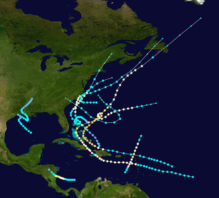
The 2008 Atlantic hurricane season was the most disastrous Atlantic hurricane season since 2005, causing over 1,000 deaths and nearly $50 billion in damage. The season ranked as the third costliest ever at the time, but has since fallen to sixth costliest. It was an above-average season, featuring sixteen named storms, eight of which became hurricanes, and five which further became major hurricanes. It officially started on June 1 and ended on November 30. These dates conventionally delimit the period of each year when most tropical cyclones form in the Atlantic basin. However, the formation of Tropical Storm Arthur caused the season to start one day early. It was the only year on record in which a major hurricane existed in every month from July through November in the North Atlantic. Bertha became the longest-lived July tropical cyclone on record for the basin, the first of several long-lived systems during 2008.

Hurricane Dennis (1999) Category 2 Atlantic hurricane in 1999

Hurricane Dennis caused flooding in North Carolina and the Mid-Atlantic states in early September 1999, which would later be compounded by Hurricane Floyd. The fifth tropical cyclone of the season, Dennis developed from a tropical wave to the north of Puerto Rico on August 24. Originally a tropical depression, the system moved west-northwestward and strengthened into a tropical storm despite unfavorable wind shear. The storm became a hurricane by August 26. After striking the Abaco Islands, conditions improved, allowing for Dennis to strengthen into a Category 2 on the Saffir–Simpson scale by August 28. Around this time, Dennis began to move parallel to the Southeastern United States. Early on August 30, the storm peaked with winds of 105 mph (165 km/h). By the following day, steering currents collapsed and the storm interacted with a cold front, causing Dennis to move erratically offshore North Carolina. Wind shear and cold air associated with the front weakened Dennis to a tropical storm on September 1 and removed some of its tropical characteristics. Eventually, warmer ocean temperatures caused some re-strengthening. By September 4, Dennis turned northwestward and made landfall in Cape Lookout, North Carolina, as a strong tropical storm. The storm slowly weakened inland, before transitioning into an extratropical cyclone over western New York on September 7.

Hurricane Emily (1987) Category 3 Atlantic hurricane in 1987

Hurricane Emily was the only major hurricane to develop during the below-average 1987 Atlantic hurricane season. Forming out of a tropical disturbance that moved off the west coast of Africa on September 20, the storm quickly attained hurricane status before undergoing rapid intensification. On September 22, the storm attained its peak intensity with winds of 125 mph (205 km/h) and a barometric pressure of 958 mbar. The storm weakened slightly to Category 2 status before making landfall in the Dominican Republic. After weakening to a tropical storm, Emily rapidly tracked northeastward through the Atlantic Ocean, undergoing a second phase of rapid intensification before passing directly over Bermuda on September 25. The following day the final public advisory from the National Hurricane Center was issued on the storm as it transitioned into an extratropical cyclone.

Hurricane Debby (2000) Category 1 Atlantic hurricane in 2000

Hurricane Debby caused minor damage in the Greater and Lesser Antilles in August 2000. The seventh tropical cyclone, fourth named storm, and second hurricane of the annual season, Debby developed from a tropical wave east of the Lesser Antilles on August 19. Favorable conditions allowed the depression to become Tropical Storm Debby early on August 20, and further strengthening into a hurricane occurred 24 hours later. Sustained winds peaked at 85 mph (140 km/h) on August 21. Debby made three landfalls on August 22, in Barbuda, Saint Barthélemy, and Virgin Gorda, before re-entering the Atlantic north of Puerto Rico. As Debby moved parallel to the north coast of Hispaniola late on August 23, it weakened back to a tropical storm. The storm tracked westward and weakened further, instead of approaching Florida and strengthening into a major hurricane. While south of eastern Cuba on August 24, Debby was downgraded to a tropical depression, six hours before completely dissipating.

Hurricane Noel Category 1 Atlantic hurricane in 2007

Hurricane Noel was a deadly and very damaging tropical cyclone that carved a path of destruction across the Atlantic Ocean from the Caribbean Sea to Newfoundland in late October 2007. The sixteenth tropical depression, fourteenth named storm, and the sixth hurricane of the 2007 Atlantic hurricane season, Noel formed on October 27 from the interaction between a tropical wave and an upper-level low in the north-central Caribbean. It strengthened to winds of 60 mph (97 km/h) before making landfall on western Haiti and the north coast of eastern Cuba. Noel turned northward, and on November 1, it attained hurricane status. The hurricane accelerated northeastward after crossing the Bahamas, and on November 2, it transitioned into an extratropical cyclone.

Tropical Storm Olga (2007) Atlantic tropical storm in 2007

Tropical Storm Olga was the fifteenth named storm of the 2007 Atlantic hurricane season. In the second week of December, after the official end of the hurricane season, a low developed east of the northernmost Lesser Antilles. It slowly acquired tropical characteristics, and late on December 10, the NHC declared it Subtropical Storm Olga while just north of Puerto Rico. It was the first post-season storm since Tropical Storm Zeta in the 2005 season, making the 2007 season one of the few with activity both before and after the official bounds of the hurricane season. Olga was only one of a few out of season tropical cyclones to make landfall. The storm made landfall on December 11 on the eastern tip of the Dominican Republic. Later that evening, Olga transitioned into a tropical storm just after making landfall. Olga tracked over Hispaniola and emerged in the Caribbean Sea. Strong wind shear and dry air caused Olga to weaken into a remnant low early on December 13.

1945 Homestead hurricane Category 4 Atlantic hurricane in 1945

The 1945 Homestead hurricane was the most intense tropical cyclone to strike the U.S. state of Florida since 1935. The ninth tropical storm, third hurricane, and third major hurricane of the season, it developed east-northeast of the Leeward Islands on September 12. Moving briskly west-northwestward, the storm became a major hurricane on September 13. The system moved over the Turks and Caicos Islands the following day and then Andros on September 15. Later that day, the storm peaked as a Category 4 hurricane on the modern-day Saffir–Simpson hurricane wind scale with winds of 130 mph (215 km/h). Late on September 15, the hurricane made landfall on Key Largo and then in southern Miami-Dade County, and across Homestead, FL where much damage was done and winds were clocked at Homestead Army Air Corps Base at 145 mph.

Timeline of the 2008 Atlantic hurricane season timeline

The 2008 Atlantic hurricane season was an event in the annual tropical cyclone season in the north Atlantic Ocean. An above-average Atlantic hurricane season season, it was the fourth most active season on record and the first to feature a major hurricane in every month from July to November.

Hurricane Edith (1963) Category 2 Atlantic hurricane in 1963

Hurricane Edith brought flooding and wind damage to portions of the Greater and Lesser Antilles. The sixth tropical storm and fifth hurricane of the 1963 season, Edith developed east of the Windward Islands on September 23 from an Intertropical Convergence Zone (ITCZ) disturbance. Initially a tropical depression, it strengthened into Tropical Storm Edith the next day. Shortly thereafter, Edith reached hurricane status. Edith fluctuated between Category 1 and 2 status as it moved west-northwest. Upon reaching Category 2 intensity on September 25, the storm peaked with winds of 100 mph (155 km/h). After striking Saint Lucia on September 25, the storm traversed the eastern Caribbean Sea. Curving north-northwest on September 26, Edith made landfall near La Romana, Dominican Republic, early on the following day as a minimal hurricane. Interaction with land and an upper-level trough caused Edith to weaken to a tropical storm on September 28 and to a tropical depression by the next day. The storm dissipated just east of the Bahamas on September 29.

2014 Atlantic hurricane season hurricane season in the Atlantic Ocean

The 2014 Atlantic hurricane season was a below average season in terms of named storms, and an average season in terms of both hurricanes and major hurricanes. It produced nine tropical cyclones, eight named storms, the fewest since the 1997 Atlantic hurricane season, six hurricanes and two major hurricanes. It officially began on June 1, 2014, and ended on November 30, 2014. These dates historically describe the period each year when most tropical cyclones form in the Atlantic basin. The first storm of the season, Arthur, developed on July 1, while the final storm, Hanna, dissipated on October 28, about a month prior to the end of the season.

Timeline of the 2014 Atlantic hurricane season

The 2014 Atlantic hurricane season was an event in the annual hurricane season in the north Atlantic Ocean. It featured below-average tropical cyclone activity, with the fewest named storms since the 1997 season. The season officially began on June 1 and ended on November 30, dates that conventionally delimit the period of each year when most tropical cyclones develop in the Atlantic basin. The season's first storm, Hurricane Arthur, developed on July 1, 2014; the season's final storm, Tropical Storm Hanna, degenerated on October 28, 2014. Altogether, there were eight named storms during the season, including six hurricanes of which two intensified into major hurricanes.

Hurricane Cristobal 2014 Atlantic hurricane

Hurricane Cristobal was a moderately strong Atlantic tropical cyclone that affected multiple landmasses from Puerto Rico to Iceland in late August and early September 2014. Slow to develop, and plagued by unfavorable wind shear for most of its life, the storm formed on August 23 near the Caicos Islands from a long-tracked tropical wave. Moving generally northward, Cristobal gradually intensified despite a ragged appearance on satellite imagery, and passed midway between Bermuda and North Carolina on August 27. While accelerating toward the northeast the next day, Cristobal achieved its peak strength as a Category 1 hurricane. A colder environment converted Cristobal into an extratropical cyclone on August 29, but it retained much of its strength as it sped across the northern Atlantic and struck Iceland on September 1.

Hurricane Joaquin Category 4 Atlantic hurricane in 2015

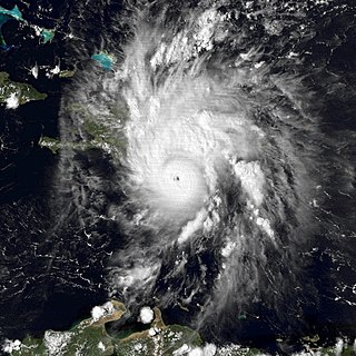
Hurricane Joaquin was a powerful tropical cyclone that devastated several districts of the Bahamas and caused damage in the Turks and Caicos Islands, parts of the Greater Antilles, and Bermuda. It was also the strongest Atlantic hurricane of non-tropical origin recorded in the satellite era. The tenth named storm, third hurricane, and second major hurricane of the 2015 Atlantic hurricane season, Joaquin evolved from a non-tropical low to become a tropical depression on September 28, well southwest of Bermuda. Tempered by unfavorable wind shear, the depression drifted southwestward. After becoming a tropical storm the next day, Joaquin underwent rapid intensification, reaching hurricane status on September 30 and Category 4 major hurricane strength on October 1. Meandering over the southern Bahamas, Joaquin's eye passed near or over several islands. On October 3, the hurricane weakened somewhat and accelerated to the northeast. Abrupt re-intensification ensued later that day, and Joaquin acquired sustained winds of 155 mph (250 km/h), just short of Category 5 strength.

References

  1. 1 2 3 4 5 6 7 8 9 10 Daniel P. Brown and Todd B. Kimberlain (December 17, 2008). Tropical Cyclone Report: Hurricane Hanna (PDF). National Hurricane Center (Report). Miami, Florida: National Oceanic and Atmospheric Administration . Retrieved May 13, 2014.
  2. Rhome (2008). "Tropical Storm Hanna Discussion Number 2". National Hurricane Center. Retrieved August 28, 2008.
  3. Stewart & Beven (2008). "Tropical Storm Hanna Discussion Number 4". National Hurricane Center. Retrieved August 30, 2008.
  4. Avila (2008). "Tropical Storm Hanna Discussion Number 5". National Hurricane Center. Retrieved August 30, 2008.
  5. Stewart (2008). "Tropical Storm Hanna Discussion Number 17". National Hurricane Center. Retrieved September 3, 2008.
  6. Rhome/Avila (2008). "Tropical Storm Hanna Discussion Number 18". National Hurricane Center. Retrieved September 3, 2008.
  7. Rhome/Avila (2008). "Hurricane Hanna Discussion Number 19". National Hurricane Center. Retrieved September 3, 2008.
  8. Rhome/Knabb (2008). "Tropical Storm Hanna Discussion Number 23". National Hurricane Center. Retrieved September 3, 2008.
  9. Knabb. "Tropical Storm Hanna Public Advisory Number 37". National Hurricane Center.
  10. Ocean Prediction Center. Fourteen Day Unified Surface Analysis Loop. Archived September 20, 2008, at the Wayback Machine Retrieved on 2008-09-15.
  11. Vivian Tyson (September 1, 2008). "Hurricane Hanna Forms; Warnings Issued for Bahamas". ABC News . Providenciales, Turks and Caicos Islands. Associated Press. Archived from the original on December 18, 2011. Retrieved May 13, 2014.
  12. Hurricane Hanna Situation Report #2. Caribbean Disaster Emergency Management Agency (Report). ReliefWeb. September 3, 2008. Retrieved May 13, 2014.
  13. "Region Prepares For Hanna's Rain". WRC-TV. September 5, 2008. Archived from the original on September 7, 2008. Retrieved September 6, 2008.
  14. Nick McMaster (September 2, 2008). "As Hanna Nears, Fla. Declares Emergency". Newser . Archived from the original on September 10, 2013. Retrieved May 15, 2014.
  15. 1 2 3 Vivian Tyson (September 1, 2008). "Hurricane Hanna Hits Bahamas, Threatens US". WCPO . Providenciales, Turks and Caicos Islands. Associated Press. Archived from the original on September 8, 2008. Retrieved September 2, 2008.
  16. "More relief moves into Louisiana as other states brace for more storms". Duncan, Oklahoma: National Rural Water Association. September 5, 2008. Archived from the original on February 26, 2012. Retrieved May 14, 2014.
  17. "News at Old Dominion University". Odu.edu. Archived from the original on September 7, 2008. Retrieved September 8, 2008.
  18. "Norfolk State University - NSUalert.com". Nsualert.com. Archived from the original on December 30, 2005. Retrieved September 8, 2008.
  19. "Regent University closed for Tropical Storm Hanna" (Press release). Regent University. September 4, 2008. Retrieved September 6, 2008.
  20. "Sep 5, 2008: Saturday Classes Cancelled" (Press release). Virginia Wesleyan College. September 5, 2008. Archived from the original on September 8, 2008. Retrieved September 6, 2008.
  21. 1 2 http://www.newsday.com/services/newspaper/printedition/monday/longisland/ny-lihann085834125sep08,0,742443.story
  22. "Weather advisory issued (08/09/05)". Fredericton, New Brunswick: Government of New Brunswick. September 5, 2008. Archived from the original on September 27, 2011. Retrieved May 14, 2014.
  23. Dunn, Gordon E; Moore, Paul L; Clark, Gilbert B; Frank, Neil L; Hill, Elbert C; Kraft, Raymond H; Sugg, Arnold L (1964). "The Hurricane Season of 1963" (PDF). Monthly Weather Review. American Meteorological Society. 92 (3): 136. Bibcode:1964MWRv...92..128D. doi:10.1175/1520-0493-92.3.128. ISSN   0027-0644. Archived (PDF) from the original on June 9, 2012. Retrieved May 13, 2012.
  24. Brown, Daniel P (December 17, 2007). Tropical Cyclone Report: Hurricane Noel (PDF) (Report). United States National Hurricane Center. p. 4. Archived from the original on June 9, 2012. Retrieved June 1, 2012.
  25. Stewart, Stacy R (April 3, 2017). Tropical Cyclone Report: Hurricane Matthew (PDF) (Report). United States National Hurricane Center. p. 4. Archived from the original on June 9, 2012. Retrieved April 6, 2017.
  26. Finnigan, Sean (October 4, 2002). Hurricane Lili almost drowns Camp-Perin, Haiti (PDF) (Report). Organisation for the Rehabilitation of the Environment. p. 1. Archived from the original on June 9, 2012. Retrieved June 9, 2012.
  27. Brown, Daniel P; Kimberlain, Todd B (March 27, 2009). Tropical Cyclone Report: Hurricane Hanna (PDF) (Report). United States National Hurricane Center. Archived from the original on June 9, 2012. Retrieved June 1, 2012.
  28. Beven II, John L; Kimberlain, Todd B (January 22, 2009). Tropical Cyclone Report: Hurricane Gustav (PDF) (Report). United States National Hurricane Center. p. 4. Archived from the original on June 9, 2012. Retrieved June 1, 2012.
  29. Roth, David M. (October 18, 2017). "Tropical Cyclone Point Maxima". Tropical Cyclone Rainfall Data. United States Weather Prediction Center. Retrieved November 26, 2017.
  30. 1 2 "Hurricane Ike targets Gulf, Hanna's toll rises". Alertnet . Salvo, North Carolina. Reuters. September 6, 2008. Archived from the original on September 12, 2008. Retrieved June 9, 2008.
  31. 1 2 "Ike kills 10 in Haiti". Otago Daily News. Associated Press. September 8, 2008. Archived from the original on May 14, 2014. Retrieved May 13, 2014.
  32. 1 2 "Body Of 14-Year-Old Caught In Rip Current Is Found". Australian Broadcasting Corporation . September 3, 2008. Archived from the original on November 8, 2012. Retrieved May 14, 2014.
  33. 1 2 William Angel. Storm Data and Unusual Weather Phenomena: September 2008 (PDF). National Climatic Data Center (Report). Asheville, North Carolina: National Oceanic and Atmospheric Administration]]. p. 175. Archived from the original (PDF) on May 14, 2014. Retrieved May 13, 2014.
  34. William Angel. Storm Data and Unusual Weather Phenomena: August 2008 (PDF). National Climatic Data Center (Report). Asheville, North Carolina: National Oceanic and Atmospheric Administration. p. 489. Archived from the original (PDF) on May 14, 2014. Retrieved May 13, 2014.
  35. Australian Broadcasting Corporation (September 2, 2008). "Tropical storm Hanna kills 10 in Haiti". ReliefWeb. Retrieved September 3, 2008.
  36. Katz, Jonathan M. (2008). "Hanna slams Haiti, leaves 25 dead". USA Today . Retrieved September 3, 2008.
  37. 1 2 "Hanna kills 14 in islands, threatens US East Coast". Fort Worth Star-Telegram. 2008. Retrieved September 2, 2008.[ dead link ]
  38. "Haiti Impact". Hurricane Hanna Info. 2008. Archived from the original on August 1, 2013. Retrieved September 4, 2008.
  39. Trenton Daniel and Francis Robels (2008). "Cuba, Haiti, the Dominican Republic and Turks and Caicos deal with destruction and death from Tropical Storm Hanna and Hurricane Gustav". Miami Herald .
  40. 1 2 Charles, Jacqueline (2008). "Horrible scene in Haiti after Hanna". Miami Herald . Retrieved September 5, 2008.[ dead link ]
  41. "Easley declares state of emergency". WRAL. Retrieved September 5, 2008.
  42. "Anne Arundel Prepares for Hanna". Capital Gazette. Retrieved September 5, 2008.
  43. "District of Columbia is Ready for Hanna". D.C. Homeland Security and Emergency Management Agency. September 5, 2008. Retrieved September 6, 2008.
  44. "Situation Report No. 6" (PDF). SC Emergency Management Division. September 6, 2008. Archived from the original (PDF) on September 9, 2008. Retrieved September 6, 2008.
  45. "Horry County EOC at OPCON 1 for Hanna". SCNOW. September 4, 2008. Archived from the original on September 9, 2012. Retrieved September 6, 2008.
  46. Joanna Poncavage (September 8, 2008). "Possible Tornado damages Dieruff". The Morning Call. Archived from the original on September 8, 2008. Retrieved September 8, 2008.
  47. "Archived copy". Archived from the original on May 21, 2011. Retrieved January 18, 2020.CS1 maint: archived copy as title (link)