Petit Jean State Park is a 3,471-acre park in Conway County, Arkansas managed by the Arkansas Department of Parks and Tourism. It is located atop Petit Jean Mountain adjacent to the Arkansas River in the area between the Ouachita Mountains and Ozark Plateaus.

Meramec State Park is a public recreation area located near Sullivan, Missouri, about 60 miles from St. Louis, along the Meramec River. The park has diverse ecosystems such as hardwood forests and glades. There are over 40 caves located throughout the park, the geology of which is a mixture of limestone and dolomite. The most famous is Fisher Cave, located near the campgrounds. The park borders the Meramec Conservation Area.

Bewabic State Park is a public recreation area covering 315 acres (127 ha) on the shore of Fortune Lake, four miles (6.4 km) west of Crystal Falls in Iron County, Michigan. The state park's rich Civilian Conservation Corps history is evidenced by the CCC structures still in use. The park was listed on the National Register of Historic Places for its CCC-related architecture in 2016.
Located near Dardanelle, Arkansas and rising 1,350 feet (410 m) above the mountain valleys of west central Arkansas, Mount Nebo has a view of 34,000 acres (140 km2) Lake Dardanelle, the Arkansas River and the surrounding mountain ridges. Atop this biblically named plateau, fringed by the Ouachita National Forest, is Mount Nebo State Park. Developed as a resort area in the late 19th century, it became a state park in 1928, its early development spearheaded by the Civilian Conservation Corps. Park activities include hiking, camping, and other outdoor pursuits.

Guernsey State Park is a public recreation area surrounding the Guernsey Reservoir, an impoundment of the North Platte River, one mile northwest of the town of Guernsey in Platte County, Wyoming, USA. The state park has campgrounds, boat ramps and hiking trails as well as exceptional examples of structures created by the Civilian Conservation Corps in the 1930s. Facilities are managed for the Bureau of Reclamation by the Wyoming Division of State Parks and Historic Sites.

The Black Moshannon State Park Historic Districts are three separate historic districts on the National Register of Historic Places (NRHP) at Black Moshannon State Park in Rush Township, Centre County, Pennsylvania in the United States. The structures in the historic districts were constructed in the 1930s during the Great Depression by the Civilian Conservation Corps (CCC). The three districts are: the Beach and Day Use District, with 18 contributing structures, including 11 different picnic pavilions, concession building, bathhouse, museum, and four open pit latrines; the Family Cabin District with 16 contributing properties, including 13 cabins, one lodge and two latrines; and the Maintenance District with four contributing properties, including a storage building, three-bay garage, gas pump house, and ranger's residence.

The Hasselborg Lake South Shelter Cabin is a historic backcountry shelter in the Admiralty Island National Monument, part of the Tongass National Forest in Southeast Alaska. It is one of a number of such facilities built by Civilian Conservation Corps (CCC) on the Admiralty Island Canoe Route between 1933 and 1937. The cabin is located on the southwest of Hasselborg Lake, north of the Hasselborg Cabin, and near the portage trail leading to Lake Guerin. As built by the CCC, it was a three-sided Adirondack-style log shelter with shake walls and roof. Sills and the lower ends of its posts have been replaced due to rot.
The Thayer Lake South Shelter Cabin is a historic backcountry shelter in the Admiralty Island National Monument, part of the Tongass National Forest in Southeast Alaska. It was one of a number of such facilities built by Civilian Conservation Corps (CCC) on the Admiralty Island Canoe Route between 1933 and 1937. This cabin, a three-sided Adirondack-style log structure with shake walls and roof, was built in 1935, and is located near the southern tip of Thayer Lake, facing a reedy stream blocked by a beaver dam. A portage trail runs nearby.

Lake Leatherwood Park is a municipal park on the north side of Eureka Springs, Arkansas. The park covers 1,600 acres (650 ha), and its centerpiece is Lake Leatherwood, a 100-acre (40 ha) body of water created by the Lake Leatherwood Dam, which impounds West Leatherwood Creek. The dam, along with roadways, recreational facilities, and other elements of the park, were built in the 1930s by work crews of the Civilian Conservation Corps (CCC) with funding from the federal government's Soil Conservation Service.

The Bard Springs Bathhouse is a historic recreational support facility in Ouachita National Forest. It is located at the Bard Springs recreation site, southeast of Mena and north of Athens in Polk County, off County Road 82 and Forest Road 106 on the banks of Blaylock Creek. It is a single story rustic stone structure, with entrances at either end into open areas for changing. The interior is lit by skylights in the roof. It was built in 1936 by a crew of the Civilian Conservation Corps, and is one of four surviving CCC structures in the immediate area.

The Bard Springs Dam No. 1 is a historic recreational support facility in Ouachita National Forest. It is located at the Bard Springs recreation site, southeast of Mena and north of Athens in Polk County, off County Road 82 and Forest Road 106 on the banks of Blaylock Creek. This dam is located at the western end of the recreation area, and is about 65 feet (20 m) long and 8 feet (2.4 m) high at its center. It is made of fieldstone, and has a series of chutes and steps across its top. It was built in 1936 by a crew of the Civilian Conservation Corps, and is one of four surviving CCC structures in the immediate area.

The Bard Springs Dam No. 2 is a historic recreational support facility in Ouachita National Forest. It is located at the Bard Springs recreation site, southeast of Mena and north of Athens in Polk County, off County Road 82 and Forest Road 106 on the banks of Blaylock Creek. This dam is located at the eastern end of the recreation area, and is about 75 feet (23 m) long and 15 feet (4.6 m) high at its center. It is made of fieldstone, and has a series of staggered steps at its base to reduce erosion. It was built in 1936 by a crew of the Civilian Conservation Corps, and is one of four surviving CCC structures in the immediate area.

The Bard Springs Picnic Shelter is a historic recreational support facility in Ouachita National Forest. It is located at the Bard Springs recreation site, southeast of Mena and north of Athens in Polk County, off County Road 82 and Forest Road 106 on the banks of Blaylock Creek. It is a square open-air structure, with four rustic stone columns supporting a gabled roof. The foundation is stone, with the support columns set in concrete blocks. It was built in 1936 by a crew of the Civilian Conservation Corps, and is one of four surviving CCC structures in the immediate area.

Shady Lake Recreation Area is a campground and public recreation area in southwestern Ouachita National Forest, southwest of Mena, Arkansas and west of Glenwood, Arkansas. The area is oriented around Shady Lake, a body of water on the South Fork Saline River impounded by a dam built c. 1940 by the Civilian Conservation Corps (CCC). The area is administered by the United States Forest Service (USFS).
Camp Clearfork is a group use recreational facility in Ouachita National Forest, west of the city of Hot Springs, Arkansas. It is located at the end of Camp Clearfork Trail, south of United States Route 270. The camp was developed in the 1930s by the Civilian Conservation Corps (CCC), and includes cabins, a recreation hall, and Camp Clearfork Reservoir, impounded by a CCC-built dam.
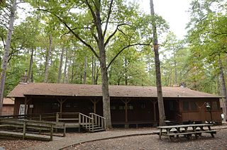
The Gray Spring Recreation Area is a picnic area with scenic views in the Ozark-St. Francis National Forest of northwestern Arkansas. It is located on northern Franklin County, on Forest Road 1003, and includes a picnic shelter, comfort facilities, an outdoor barbecue pit, and picnic tables. The picnic area and Forest Road 1003 were built in 1934 by a crew from the Civilian Conservation Corps, and were listed on the National Register of Historic Places in 1995. The road, which winds precariously around Black Mountain, retains a number of surviving CCC-built features, including a bridge and many stone culverts.
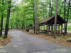
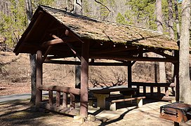
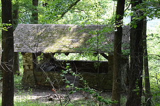
The Collier Springs Picnic Area is located on Forest Road 177 in Ouachita National Forest, northeast of Norman, Arkansas. The picnic area is notable for the presence of the Collier Springs Shelter, which was built by crews of the Civilian Conservation Corps in 1939. It is a rectangular open-air stone structure, with stone columns topped by hewn log beams that support the gabled roof. The shelter also acts as a protective cover for the eponymous spring, which is fed via a pipe to the nearby creek. Facilities at the picnic area also include a vault toilet.

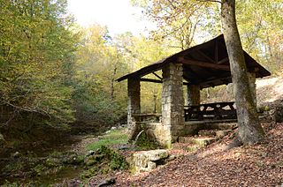
The Crystal Campground is located on Forest Road 177 in Ouachita National Forest, northeast of Norman, Arkansas. The campground has nine campsites and a picnic shelter, and provides access to outdoor recreational activities including hiking, swimming, and fishing. The swimming area is made possible by the Crystal Springs Dam, a 30-foot (9.1 m) fieldstone dam built in 1935 by the Civilian Conservation Corps, that impounds Montgomery Creek to provide a swimming hole. The campground's main picnic shelter was also built by the CCC at that time. Both the dam and the shelter were listed on the National Register of Historic Places in 1993.

The Spring Lake Recreation Area is a recreational facility of the Ozark-St. Francis National Forest in Yell County, Arkansas. It is located north of Danville, in and around Spring Lake, a man-made lake constructed in 1937 with funding from the Works Progress Administration. The area has facilities for fishing and picnicking, including many structures built with WPA funding the Rustic style common to work of the Civilian Conservation Corps. Facilities from that period include picnic pavilions and developed picnic sites, a bathhouse, two swimming platforms, the Spring Lake Bridge, and the dam which impounds Spring Creek at the southern end of the lake. The area was listed on the National Register of Historic Places in 1995 as the Spring Lake Recreation Area Historic District.

Lacey-Keosauqua State Park is located southwest of Keosauqua, Iowa, United States. The park located along the Des Moines River in Van Buren County, it was dedicated in 1921. It is the largest state park in size in Iowa. In 1990 three areas were named nationally recognized historic districts and listed on the National Register of Historic Places.