
Canterbury is a town in Windham County, Connecticut, United States. The population was 5,132 at the 2010 census.

Westville is a neighborhood of the city of New Haven, Connecticut. It is consistently ranked as one of the best neighborhoods to live in New Haven due to its high home values, low crime rates, walkable streets, proximity to downtown, and local amenities.

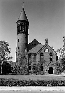
Prudence Crandall was an American schoolteacher and activist. She ran the first school for black girls in the United States, located in Canterbury, Connecticut.
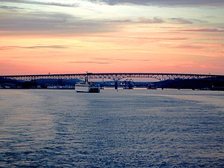
Quaker Hill is a village or neighborhood in the town of Waterford, in the southeastern part of Connecticut, USA.

Neighborhoods in Spokane, Washington are officially grouped by the Spokane City Council into three main city council districts: 1, 2, and 3. Each city council district contains multiple, official neighborhoods that are recognized with a neighborhood council. Informally, neighborhoods are colloquially grouped by local geographical, geological, cultural, or historical features The list of neighborhoods below is organized based on the official designations by the City of Spokane. Unofficial neighborhoods and districts are listed within the official neighborhood in which they are located.
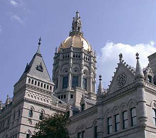
The neighborhoods of Hartford, Connecticut in the United States are varied and historic.

Fountain Square is one of seven designated cultural districts in Indianapolis, Indiana. Located right outside the city's downtown district, Fountain Square is home to three designated national historic districts, the Laurel and Prospect, the State and Prospect, and the Virginia Avenue districts, all of which were listed on the National Register of Historic Places in 1983. The neighborhood derives its name from the successive fountains that have been prominently featured at the intersection of Virginia Avenue, East Prospect Street, and Shelby Street.

The Wooster Square Historic District encompasses much of the Wooster Square neighborhood of New Haven, Connecticut. Centered on a rectangular park named in honor of General David Wooster, the area was developed as a residential neighborhood beginning in the 1820s, and was by the 1840s a desirable area to live, with many high-quality Greek Revival homes. In the 1950s the area was the subject of a major community-led preservation effort that drew national attention. The district was listed on the National Register of Historic Places in 1971.

Several neighborhoods of Norwich, Connecticut maintain independent identities and are recognized by official signs marking their boundaries. The following is a list of neighborhoods in Norwich.
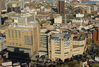
The Hill is the southwesternmost neighborhood of New Haven, Connecticut. As early as 1800, this area was known as "Sodom Hill". Located directly south of Downtown New Haven, the neighborhood is now home to New Haven Union Station as well as Yale-New Haven Hospital and the Yale School of Medicine.
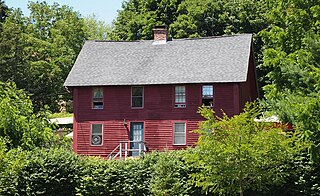
The Quaker Hill Historic District encompasses the center a mainly residential village in northeastern Waterford, Connecticut. Running in a mostly linear fashion along Old Norwich Road between Connecticut Route 32 and Richard Grove Road, the area first grew as a settlement of religious non-conformists in the 17th century, developed in the 19th century as a small industrial village, and became more suburban in character in the 20th century. Its architecture is reflective of these changes, and it was listed on the National Register of Historic Places in 2002.

Prospect Hill is a neighborhood of the city of New Haven, Connecticut located in the north central portion of the city, directly north of Downtown New Haven. The neighborhood contains residences, institutional buildings of Albertus Magnus University and a portion of the main campus of Yale University, including the Science Hill area, the Hillhouse Avenue area and the Yale Peabody Museum. The City of New Haven defines the neighborhood to be the region bounded by the town of Hamden in the north, Winchester Avenue in the west, Munson Street/Hillside Place/Prospect Street in the southwest, Trumbull Street in the south, and Whitney Avenue in the east. Prospect Street is the main thoroughfare through the neighborhood.
The city of New Haven, Connecticut has many distinct neighborhoods. In addition to Downtown, centered on the central business district and the Green, are the following neighborhoods: the west central neighborhoods of Dixwell and Dwight; the southern neighborhoods of The Hill, historic water-front City Point, and the harborside district of Long Wharf; the western neighborhoods of Edgewood, West River, Westville, Amity, and West Rock; East Rock, Cedar Hill, Prospect Hill, and Newhallville in the northern side of town; the east central neighborhoods of Mill River and Wooster Square, an Italian-American neighborhood; Fair Haven, an immigrant community located between the Mill and Quinnipiac rivers; Quinnipiac Meadows and Fair Haven Heights across the Quinnipiac River; and facing the eastern side of the harbor, The Annex and East Shore.
The Chelsea Parade Historic District encompasses a predominantly residential area north of downtown Norwich. Centered around the Chelsea Parade, a triangular public park, the area has long been a preferred residential area for the city's upper classes, and includes a catalog of architecture from the 18th to 20th centuries. It includes 565 contributing buildings, two other contributing sites, and six contributing objects over an area of 205 acres (83 ha). The district was listed on the National Register of Historic Places in 1989.

College Hill is a residential neighborhood in Easton, Pennsylvania. The neighborhood is situated on the hill overlooking downtown Easton which was once known as Mount Lafayette, and before that, Mount Washington. Lafayette College borders the neighborhood on its southwest side. The northern boundary of the neighborhood is Forks Township. The boundary lies along Chestnut Ridge, a steep hill that rises to 700 feet. College Hill has a total of three historic religious institutional buildings, three parks, and the remains of Rinek Mansion grounds.

The Yantic Falls Historic District encompasses a historic mill and associated worker housing on Yantic Street in Norwich, Connecticut. The 10-acre (4.0 ha) area includes a complex of mill buildings, mainly built in brick, and mill worker housing, also out of brick. The area's industrial history dates to the early 19th century. The district was listed on the National Register of Historic Places on June 28, 1972.

The Laurel Hill Historic District is a predominantly residential historic district south of downtown Norwich, Connecticut. The district was added to the National Register of Historic Places on October 26, 1987. It extends south from the Shetucket River along Laurel Hill Avenue, River Avenue, and Spruce Street. This area was developed as a residential district beginning in 1850, and includes a significant number of well-preserved Italianate and Gothic Revival houses.

Trowbridge Square Historic District, originally known as Village of Spireworth and Mount Pleasant, is a well-preserved 19th-century neighborhood in the Hill section New Haven, Connecticut. Roughly bounded by Columbus, Howard, and Union Avenues, and Church Street on the east, the area was laid out in 1830 and developed as a working-class neighborhood. It retains its historic streetscape, and many original buildings, representing modest versions of a diversity of mid-to-late 19th century styles. The district was listed on the National Register of Historic Places in 1985.

The Westminster Terrace Historic District encompasses a locally architecturally distinctive residential area on Westminster Terrace in Bellows Falls and Westminster, Vermont. First developed between about 1880 and 1910, the neighborhood has high-quality late 19th-century homes, interspersed with later mid-20th century development. It was listed on the National Register of Historic Places in 2010.
The Golden Hill Historic District encompasses a well-preserved formerly residential area on the northwest fringe of downtown Bridgeport, Connecticut. Located mainly on Lyon Terrace, Gold Hill Street, and Congress Street, the district includes 11 formerly residential buildings now mainly in commercial use, which were built between about 1890 and 1930. It also includes Bridgeport City Hall, and the Golden Hill United Methodist Church. The district was listed on the National Register of Historic Places in 1987.


