
This is a list of sites in Minnesota which are included in the National Register of Historic Places. There are more than 1,700 properties and historic districts listed on the NRHP; each of Minnesota's 87 counties has at least 2 listings. Twenty-two sites are also National Historic Landmarks.

This list is intended to be a complete compilation of properties and districts listed on the National Register of Historic Places in Rensselaer County, New York, United States. Seven of the properties are further designated National Historic Landmarks.

The Cliffs is a historic country house located near 33rd and Oxford Streets in East Fairmount Park, Philadelphia. It is a Registered Historic Place.
The history of the National Register of Historic Places began in 1966 when the United States government passed the National Historic Preservation Act (NHPA), which created the National Register of Historic Places (NRHP). Upon its inception, the U.S. National Park Service (NPS) became the lead agency for the Register. The Register has continued to grow through two reorganizations, one in the 1970s and one in 1980s and in 1978 the NRHP was completely transferred away from the National Park Service, it was again transmitted to the NPS in 1981.

This list is of the properties and historic districts which are designated on the National Register of Historic Places or that were formerly so designated, in Hennepin County, Minnesota; there are 190 entries as of April 2023. A significant number of these properties are a result of the establishment of Fort Snelling, the development of water power at Saint Anthony Falls, and the thriving city of Minneapolis that developed around the falls. Many historic sites outside the Minneapolis city limits are associated with pioneers who established missions, farms, and schools in areas that are now suburbs in that metropolitan area.
This is a complete list of National Register of Historic Places listings in Ramsey County, Minnesota. It is intended to be a complete list of the properties and districts on the National Register of Historic Places in Ramsey County, Minnesota, United States. The locations of National Register properties and districts for which the latitude and longitude coordinates are included below, may be seen in an online map.

This is a list of the National Register of Historic Places listings in Monterey County, California.
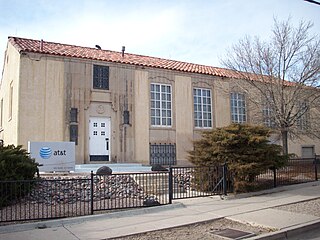
The AT&T Building is a historic building located at the corner of Pine and Third Streets in Kingman, Arizona. The building was built in 1930 by contractors Mead & Mount. Architects Fisher & Fisher designed the building in the Spanish Colonial Revival style. Built in a residential area, the building is still used by AT&T. The building was placed on the National Register of Historic Places in 1986.

The Palmer Woods Historic District is a neighborhood located in Detroit, Michigan, bounded by Seven Mile Road, Woodward Avenue, and Strathcona Drive. There are approximately 295 homes in the 188-acre (0.76 km2) district, which is between the City of Highland Park in Wayne County and the City of Ferndale in Oakland County. It was listed on the National Register of Historic Places in 1983. The Detroit Golf Club is nearby.
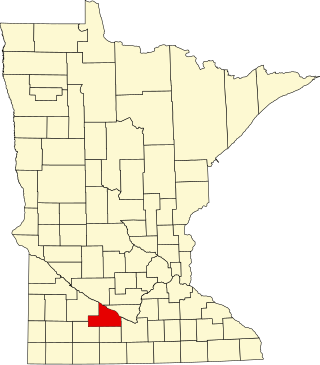
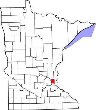
This is a list of the National Register of Historic Places listings in Brown County, Minnesota. It is intended to be a complete list of the properties and districts on the National Register of Historic Places in Brown County, Minnesota, United States. The locations of National Register properties and districts for which the latitude and longitude coordinates are included below, may be seen in an online map.

This is a list of National Register of Historic Places listings in New Haven, Connecticut.

This is a list of the National Register of Historic Places listings in Faribault County, Minnesota. This is intended to be a complete list of the properties and districts on the National Register of Historic Places in Faribault County, Minnesota, United States. The locations of National Register properties and districts for which the latitude and longitude coordinates are included below, may be seen in an online map.
The Lewis M. Fisher House is a historic building located on the east side of Davenport, Iowa, United States. It has been listed on the National Register of Historic Places since 1983.

This is a list of the National Register of Historic Places listings in Martin County, Minnesota. It is intended to be a complete list of the properties and districts on the National Register of Historic Places in Martin County, Minnesota, United States. The locations of National Register properties and districts for which the latitude and longitude coordinates are included below, may be seen in an online map.

The Clarkson S. Fisher Federal Building and United States Courthouse, originally known as the United States Courthouse and Federal Building, is located in Trenton, Mercer County, New Jersey. It houses the United States District Court for the District of New Jersey.

The Whitehill House is a historic house on Groton-Peacham Road in Ryegate, Vermont. Built in 1808, it is the oldest surviving building in Ryegate, and a distinctive example of stonework by Scottish immigrants. It was listed on the National Register of Historic Places in 1975.
The West Point Historic District in West Point, Kentucky is a 55 acres (22 ha) historic district which was listed on the National Register of Historic Places in 1996.

The Fort Street Historic District in Boise, Idaho, contains roughly 47 blocks located within the 1867 plat of Boise City. The irregular shape of the district is roughly bounded on the north by West Fort Street and on the south by West State Street. The west boundary is North 16th Street, and the east boundary is roughly North 5th Street.


