Florianópolis is the capital and second largest city of the state of Santa Catarina, in the South region of Brazil. The city encompasses Santa Catarina Island and surrounding small islands, as well as part of the mainland. It has a population of 508,826, according to the 2020 IBGE population estimate, the second-most populous city in the state, and the 47th in Brazil. The metropolitan area has an estimated population of 1,111,702, the 21st largest in the country. The city is known for having the country's third highest Human Development Index score among all Brazilian cities (0.847).

Guanabara Bay is an oceanic bay located in Southeast Brazil in the state of Rio de Janeiro. On its western shore lie the cities of Rio de Janeiro and Duque de Caxias, and on its eastern shore the cities of Niterói and São Gonçalo. Four other municipalities surround the bay's shores. Guanabara Bay is the second largest bay in area in Brazil, at 412 square kilometres (159 sq mi), with a perimeter of 143 kilometres (89 mi).
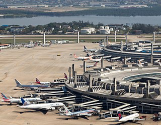
Rio de Janeiro/Galeão–Antonio Carlos Jobim International Airport, popularly known by its original name Galeão International Airport, is the main airport serving Rio de Janeiro, Brazil.

Angra dos Reis is a Brazilian municipality located in the southern part of the state of Rio de Janeiro. The city is located by the sea and includes in its territory many offshore islands, the largest being Ilha Grande.

Associação Atlética Portuguesa, also known as Portuguesa Carioca, Portuguesa do Rio or Portuguesa da Ilha, and also nicknamed Lusa, is a Brazilian professional association football club based in Governador Island, Rio de Janeiro. The team plays in Série D, the fourth tier of the Brazilian football league system, as well as in the Campeonato Carioca, the top tier of the Rio de Janeiro state football league.

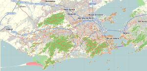
Governador Island is the largest island in Guanabara Bay, in Rio de Janeiro, Brazil. It has a population of about 211,018 inhabitants, in a small area of 42 km2 (16 sq mi).

Ilha Grande is an island located off the coast of Rio de Janeiro state, Brazil. The island, which is part of the municipality of Angra dos Reis, remains largely undeveloped. For almost a century it was closed by the Brazilian government to free movement or settlement because it first housed an immigration quarantine station and later a top-security prison. The Cândido Mendes prison, which housed some of the most dangerous prisoners within the Brazilian penal system, was finally closed in 1994. The largest village on the island is called Vila do Abraão with approximately 1900 inhabitants.

Vidigal is a neighborhood and a favela in Rio de Janeiro, Brazil.

The coastline of Brazil measures 7,491 km, which makes it the 16th longest national coastline of the world. All the coast lies adjacent to the Atlantic Ocean.

Galeão Air Force Base – ALA11 is a base of the Brazilian Air Force located in Rio de Janeiro, Brazil. It is named after nearby Praia do Galeão, where in 1663 the galleon Padre Eterno was built.
The Grêmio Recreativo Escola de Samba União da Ilha do Governador was founded on March 7, 1953 by the friends Maurício Gazelle, and Quincas Orphylo, who were in Cacuia, the main site of the carnival parade of the Ilha do Governador, watching the presentation of small schools of samba and blocks of various districts of the island. It was then decided that the neighborhood of Cacuia should be represented by a samba school. Currently, the school is based in Estrada do Galeão in the neighborhood of Cacuia.

Praia do Sul State Biological Reserve is a biological reserve on the island of Ilha Grande, in the State of Rio de Janeiro, in Brazil.

Freguesia (Ilha do Governador) is a neighborhood in the North Zone of Rio de Janeiro, Brazil.

Galeão is a neighborhood in the North Zone of Rio de Janeiro, Brazil. It is located on Governador Island besides the Rio de Janeiro–Galeão International Airport.

Muriqui is a district of the municipality of Mangaratiba, located within the Greater Rio de Janeiro, Brazil. It is part of the Green Coast. Highway BR-101 passes through the district.

The Aventureiro Sustainable Development Reserve, formerly the Aventureiro Marine State Park, is a sustainable development reserve in the state of Rio de Janeiro, Brazil. It supports artisanal fishing by a small traditional community on the Ilha Grande, an island off the southwest coast of the state.

The Rio de Janeiro gubernatorial election of October 2018 was for the election of the Governor and Vice Governor of Rio de Janeiro and 70 State Deputies. People also voted for 2 of 3 Senators of the state representation in the Federal legislative power, with 45 federal deputies representatives of the Rio de Janeiro State. A second round was held after no candidate managed to secure more than 50% of the Governor votes.
The following outline is provided as an overview of and topical guide to Rio de Janeiro:
Miss Brazil World 2016 was the 27th edition of the Miss Brazil World pageant and the 2nd under CNB Miss Brazil. The contest took place on June 25, 2016. Each state, the Federal District and various Insular Regions & Cities competed for the title. Catharina Choi of Ilhabela crowned her successor, Beatrice Fontoura of Goiás at the end of the contest. Fontoura represented Brazil at Miss World 2016. The contest was held at the Resort Il Campanario in Florianópolis, Santa Catarina, Brazil.