Rio de Janeiro, or simply Rio, is the second-most populous city in Brazil and the sixth-most populous in the Americas. Rio de Janeiro is the capital of the state of Rio de Janeiro, Brazil's third-most populous state, after São Paulo and Minas Gerais. Part of the city has been designated as a World Heritage Site, named "Rio de Janeiro: Carioca Landscapes between the Mountain and the Sea", by UNESCO on 1 July 2012 as a Cultural Landscape.

Niterói is a municipality of the state of Rio de Janeiro in the southeast region of Brazil. It lies across Guanabara Bay facing the city of Rio de Janeiro and forms part of the Rio de Janeiro Metropolitan Area. It was the state capital, as marked by its golden mural crown, from 1834 to 1894 and again from 1903 to 1975. It has an estimated population of 515,317 inhabitants (2020) and an area of 129.375 km2 (49.952 sq mi), making it the fifth most populous city in the state. It has the highest Human Development Index of the state and the seventh largest among Brazil's municipalities in 2010. Individually, it is the second municipality with the highest average monthly household income per capita in Brazil and appears in 13th place among the municipalities of the country according to social indicators related to education. The city has the nicknames of Nikity, Nicki City and the Smile City (Cidade Sorriso).
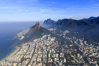
Leblon is a neighborhood of Rio de Janeiro, Brazil. It is also the name of the local beach. The neighborhood is located in the South Zone of the city, between Lagoa Rodrigo de Freitas, Morro Dois Irmãos and the Jardim de Alah channel, bordering the Gávea, Ipanema, Lagoa, and Vidigal neighborhoods. It is regarded as having the most expensive price per residential square meter in Latin America.

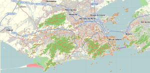
Governador Island is the largest island in Guanabara Bay, in Rio de Janeiro, Brazil. It has a population of about 211,018 inhabitants, in a small area of 42 km2 (16 sq mi).

Barra da Tijuca is a upper-class neighborhood or bairro in the West Zone of Rio de Janeiro, Brazil, located in the western portion of the city on the Atlantic Ocean. Barra is well known for its beaches, its many lakes and rivers, and its lifestyle. This neighbourhood represents 4.7% of the city population and 13% of the total area of Rio de Janeiro.
Jacarepaguá, with a land area of 29.27 square miles (75.8 km2), is a neighborhood situated in the West Zone of Rio de Janeiro, Brazil. In 2010, it had a population of 157,326. The name comes from the indigenous name of the location, "shallow pond of caymans", yakaré + upá (pond) + guá (shallow), by the time of the Portuguese colonization.

Jardim Botânico is a wealthy residential neighborhood of Rio de Janeiro, Brazil, located north of Ipanema and Leblon, just across Lagoa Rodrigo de Freitas and east of Gávea. Jardim Botânico lies in the South Zone of Rio de Janeiro.

Rodrigo de Freitas Lagoon is a lagoon in the district of Lagoa in the Zona Sul area of Rio de Janeiro. The lagoon is connected to the Atlantic Ocean, allowing sea water to enter by a canal along the edge of a park locally known as Jardim de Alah.
Gávea is an affluent residential neighborhood located in the South Zone of the city of Rio de Janeiro, Brazil. It borders São Conrado, Leblon, Lagoa and Jardim Botânico neighborhoods and is famous for its high concentration of artists and intellectuals. PUC-Rio, one of the more important Brazilian universities, as well as several schools are located in the neighborhood. Gávea is well known because of the "Baixo Gávea" area, which is considered a Bohemian quarter and which is frequented by the city's youth.
Jardim Botânico, Portuguese for botanical garden, may refer to:
Freguesia is a neighborhood in the West Zone of the city of Rio de Janeiro, Brazil. In 2000, its estimated population was 54,010 inhabitants.
Campo Grande is the largest neighborhood in the West Zone of Rio de Janeiro. Campo Grande has a population of 328,370 inhabitants and an area of 119,1253 sq km, on both counts Rio's largest. It is situated 50 kilometers away from Downtown Rio.
Santíssimo is a neighborhood in the West Zone of Rio de Janeiro, Brazil, near Campo Grande. Most residents are in the low-income group.
Paciência is a neighborhood in the West Zone of Rio de Janeiro, Brazil.
Irajá is a neighborhood of middle class and lower middle in the North Zone of Rio de Janeiro, Brazil. The neighborhood is divided by Brazil Avenue. Today it is a neighborhood of medium size, with a little more than 100,000 inhabitants.
Guadalupe is a neighborhood located in the North Zone of Rio de Janeiro, Brazil. It is surrounded by Barros Filho, Honório Gurgel, Marechal Hermes, Deodoro, Ricardo de Albuquerque, Costa Barros and Anchieta. Its designation is a homage to Our Lady of Guadalupe which main church in Rio de Janeiro is located in this neighbourhood. The neighbourhood was built as a project of former Casa Popular Foundation and it was inaugurated by president Getúlio Vargas. Are also notable in the neighbourhood the "Igloos of Guadalupe", a set of houses in hemisphere shape, looking like igloos, and built in the late 1940s on Calama street.
Jardim América is a neighborhood in the North Zone of Rio de Janeiro, Brazil.
Jardim Carioca is a neighborhood in the North Zone of Rio de Janeiro, Brazil.
Jardim Guanabara is a neighborhood located in Ilha do Governador, Rio de Janeiro, Brazil. A point of interest is a beach named Praia da Bica, with a view of the city.

Grumari is a neighborhood in the West Zone of Rio de Janeiro, Brazil. Grumari is a municipal park and is the city's only neighborhood with no residents. Grumari has beaches that have not changed in hundreds of years. Salt marsh vegetation grows next to the beach and a rain forest surrounds its hills.