Recreio dos Bandeirantes

Last updated
Recreio dos Bandeirantes
Neighborhood
Vista sob a pedra do Pontal visualizando Praia do Recreio.jpg
Recreio dos Bandeirantes.svg
Brazil location map.svg
Red pog.svg
Recreio dos Bandeirantes
Location in Brazil
Coordinates: 23°00′59″S43°28′45″W / 23.01639°S 43.47917°W / -23.01639; -43.47917
Country Flag of Brazil.svg  Brazil
State Rio de Janeiro (RJ)
Municipality/City Rio de Janeiro
Zone West Zone

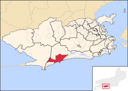
Recreio dos Bandeirantes (or simply Recreio) is both the name of a beach and neighborhood in the West Zone of Rio de Janeiro, Brazil. It is a recent development, with no skyscrapers, and the area also contains jungles atop rocky cliffs and hills. High waves permit surfing at Recreio Beach and the white sand beach is used by beach volleyball players. It is about 35 km from the Rio de Janeiro city centre, and most of the people living there are middle-class and high middle-class families, who moved in trying to escape the growing violence of both the North and South Zones.[ citation needed ]

Apocryphally, the neighborhood received the name Recreio dos Bandeirantes, or "Bandeirantes' Leisure" because the company that mapped and hired a real estate agent to sell lots there had that name.[ citation needed ] Another version says that many of the newcomers were from São Paulo, the city from which the Bandeiras departed in colonial times, and therefore Paulistas are associated with them.[ citation needed ] Still another version states that Recreio was the first (or last) resting place with fresh water for Bandeirantes traveling between Rio de Janeiro and São Paulo.[ citation needed ]

Recreio dos Bandeirantes Recreio2011.JPG
Recreio dos Bandeirantes

Development in the area began in 1959, and only more recently, have well-to-do residents discovered and made Recreio their home. Despite a high population density, the neighborhood is mostly residential and does not have the busy nightlife of more central neighborhoods like Lapa, Copacabana, Leblon, and Ipanema, but there has been an increase in the number of restaurants, pizzerias, bars, private schools and colleges. There are a few favelas , or slums, in the section. Recreio has an organized association of residents who communicate online with tips and news about the neighborhood. They have been able to address the need for the city building a ciclovia—a road for bicycles—and authorities have been persuaded to build, in the future, two subway stations in the section to facilitate commuting to downtown and the South Side (which would otherwise take about 1.5 h).


Related Research Articles

<span class="mw-page-title-main">Rio de Janeiro</span> Second-most populous city in Brazil

Rio de Janeiro, or simply Rio, is the capital of the state of the same name, and the second most populous city in Brazil, after São Paulo. Listed by the GaWC as a beta global city, Rio de Janeiro is the sixth most populous city in the Americas. Part of the city has been designated as a World Heritage Site, named "Rio de Janeiro: Carioca Landscapes between the Mountain and the Sea", on 1 July 2012 as a Cultural Landscape.

<span class="mw-page-title-main">Niterói</span> Municipality in Southeast, Brazil

Niterói is a municipality of the state of Rio de Janeiro in the southeast region of Brazil. It lies across Guanabara Bay facing the city of Rio de Janeiro and forms part of the Rio de Janeiro Metropolitan Area. It was the state capital, as marked by its golden mural crown, from 1834 to 1894 and again from 1903 to 1975. It has an estimated population of 515,317 inhabitants (2020) and an area of 129.375 km2 (49.952 sq mi), making it the fifth most populous city in the state. It has the highest Human Development Index of the state and the seventh highest among Brazil's municipalities in 2010. Individually, it is the second municipality with the highest average monthly household income per capita in Brazil and appears in 13th place among the municipalities of the country according to social indicators related to education. The city has the nicknames of Nikiti, Nicki City and the Smile City (Cidade Sorriso).

<span class="mw-page-title-main">Favela</span> Shanty town or slum in Brazil

Favela is an umbrella name for several types of working-class neighborhoods in Brazil. The term, which means slum or ghetto, was first used in the Slum of Providência in the center of Rio de Janeiro in the late 19th century, which was built by soldiers who had lived under the favela trees in Bahia and had nowhere to live following the Canudos War. Some of the first settlements were called bairros africanos. Over the years, many former enslaved Africans moved in. Even before the first favela came into being, poor citizens were pushed away from the city and forced to live in the far suburbs.

<span class="mw-page-title-main">War of the Emboabas</span>

The War of the Emboabas was a conflict in colonial Brazil waged in 1706-1707 and 1708-1709 over newly discovered gold fields, which had set off a rush to the region between two generations of Portuguese settlers in the viceroyalty of Brazil - then the Captaincy of São Vicente. The discovery of gold set off a rush to the region, Paulistas asserted rights of discovery and non-Paulistas challenged their claims. Although the Portuguese crown sought more control in the area and the Paulistas sought protection of their claims, the Emoboabas won. The crown re-assessed its position in the region and made administrative changes subsequently.

<span class="mw-page-title-main">São José dos Campos</span> Municipality in Southeast, Brazil

São José dos Campos is a major city and the seat of the municipality of the same name in the state of São Paulo, Brazil. One of the leading industrial and research centers with emphasis in aerospace sciences in Latin America, the city is located in the Paraíba Valley, between the two most active production and consumption regions in the country; São Paulo and Rio de Janeiro. It is the main city of the Metropolitan Region of Vale do Paraíba e Litoral Norte. A native of São José dos Campos is called a joseense. Being the second most populous non-capital city in Brazil – behind Campinas – São José dos Campos lies in the middle of the Expanded Metropolitan Complex, the first megalopolis in the Southern Hemisphere, with over thirty million inhabitants. The city's metro area also includes Greater São Paulo, Campinas, Santos and Sorocaba. The municipality concentrates many major companies and industries, such as Embraer, Panasonic, Johnson & Johnson, Ericsson, Philips, General Motors, Petrobras, Monsanto among others. São José dos Campos also holds relevant education and research institutions, as ITA, INPE, CEMADEN, IEAv, IEA, IFI, UNESP, UNIFESP, DCTA, FATEC, UNIVAP and IP%D, holding a position the puts the city as the main and largest Aerospacial Complex in Latin America. Thus, it is also considered the warlike producer centre. The Technological Park, the largest one in the country, is the only research institute in the world that converges all the three top global plane production companies, Embraer, Boeing and Airbus.

<span class="mw-page-title-main">Cruzeiro, São Paulo</span> Municipality in Southeast Brazil, Brazil

Cruzeiro is a municipality in the state of São Paulo in Brazil. It is located about 220 km (137 mi) from the state capital. It is part of the Metropolitan Region of Vale do Paraíba e Litoral Norte. The population is 82,571 in an area of 305,70 km2.

<span class="mw-page-title-main">Ipanema</span> Neighbourhood in Rio de Janeiro, Rio de Janeiro, Brazil

Ipanema is a neighbourhood located in the South Zone of the city of Rio de Janeiro, Brazil, between Leblon and Arpoador. The beach at Ipanema became known internationally with the popularity of the bossa nova song, "The Girl from Ipanema", written by Antônio Carlos Jobim and Vinícius de Moraes.

<span class="mw-page-title-main">Cortiço</span>

Cortiço, or gueto, is a common Portuguese term used in Brazil and Portugal for an area of concentrated, high density urban housing where people live with poor sanitation and hygiene conditions. Cortiço houses are typically divided into small rooms that are rented. Cortiços exist in large cities such as São Paulo, Salvador, Rio de Janeiro, and Recife. They originated in São Paulo, Brazil, during the late 1700s, and continue to exist in contemporary times in Rio de Janeiro and São Paulo. Less common today, most cortiços are old buildings in the central, older parts of the cities.

<span class="mw-page-title-main">Barra da Tijuca</span> District in Rio de Janeiro, Brazil

Barra da Tijuca is an upper-class neighborhood or bairro in the West Zone of Rio de Janeiro, Brazil, located in the western portion of the city on the Atlantic Ocean. Barra is well known for its beaches, its many lakes and rivers, and its lifestyle. This neighbourhood represents 4.7% of the city population and 13% of the total area of Rio de Janeiro.

<span class="mw-page-title-main">Laranjeiras</span> Neighborhood in Rio de Janeiro, Rio de Janeiro, Brazil

Laranjeiras is an upper-middle-class neighborhood located in the South Zone of Rio de Janeiro, Brazil. Primarily residential, It is one of the city's oldest neighborhoods, having been founded in the 17th century, with the construction of country houses in the valley located around the Carioca River, which bordered Corcovado Mountain. Because of this, the neighborhood was previously called Vale do Carioca, or Carioca Valley.

<span class="mw-page-title-main">Rodovia José Magalhães Teixeira</span> High-speed ring road of Campinas, Brazil

The Rodovia José Magalhães Teixeira is the Campinas Beltway, a ring of high-speed highways surrounding the city of Campinas, in the state of São Paulo, Brazil. The Campinas Beltway is the Northern vertex of the Macrometropolitan Highway System of Greater São Paulo and one of the few complete metropolitan beltways in the country. It is an extensive structure, which directly interconnects 6 large double-lane highways to all quadrants of the state. Furthermore, it is superdimensioned, i.e., it has enough capacity to accommodate huge traffic loads without getting congested, even in peak hours.

<span class="mw-page-title-main">Alphaville, São Paulo</span> Real estate development in Brazil

Alphaville, São Paulo is an affluent district split between the municipalities of Barueri and Santana de Parnaíba suburbs of São Paulo. The Alphaville concept is a real estate and gated community development in Brazil, constituted by a number of business and residential condominium. The name evokes the "first among cities" concept.

<span class="mw-page-title-main">Torres, Rio Grande do Sul</span> City in South, Brazil

Torres is a city on the coast of south Brazil in the state of Rio Grande do Sul. The city has a population of approximately 40,000 inhabitants, of which 10,000 live in rural zones, but in summer the number of inhabitants reaches 300,000.

<span class="mw-page-title-main">Rede Bandeirantes</span> Brazilian commercial television network

Rede Bandeirantes, or simply known as Band, is a Brazilian free-to-air television network. It began broadcasting on May 13, 1967 on VHF channel 13 in São Paulo. Its founder was businessman João Saad with the help of his father-in-law and former São Paulo governor Adhemar de Barros. In terms of audience and revenue, it is currently the fourth largest Brazilian television network. It broadcasts throughout Brazil through its owned-and-operated stations and affiliates. It also has a series of pay TV channels and it broadcasts internationally via Band Internacional.

<span class="mw-page-title-main">Engenho Novo</span> Neighborhood in Rio de Janeiro, Rio de Janeiro, Brazil

Engenho Novo is a neighborhood of middle class and lower middle of the North Zone of Rio de Janeiro, Brazil.

<span class="mw-page-title-main">Barra de Guaratiba</span> Neighborhood in Rio de Janeiro, Rio de Janeiro, Brazil

Barra de Guaratiba is a neighborhood in the Western Zone of Rio de Janeiro, Brazil.

<span class="mw-page-title-main">Jaraguá (district of São Paulo)</span> Neighborhood of São Paulo in Brazil

Jaraguá is a district located in the northwest zone of the Brazilian city of São Paulo, which became a district in 1948, in areas divided from Perus, Pirituba and the former sub-district of "Nossa Senhora do Ó". Jaraguá borders the municipalities of Osasco to the west, and Caieiras to the north. Also with the districts of Perus, Anhanguera, Brasilândia, São Domingos and Pirituba.

<span class="mw-page-title-main">Pontal (Rio de Janeiro)</span>

Pontal is a small peninsula and beach area in the Recreio dos Bandeirantes neighborhood, located in the West Zone of Rio de Janeiro, Brazil and was a temporary venue in the Barra Olympic venues cluster for the Athletics and Cycling competitions of the 2016 Summer Olympics.

<span class="mw-page-title-main">Geography of Rio de Janeiro</span> Environment, climate and subdivisions of Rio de Janeiro

Rio de Janeiro is on the far western part of a strip of Brazil's Atlantic coast, close to the Tropic of Capricorn, where the shoreline is oriented east–west. Facing largely south, the city was founded on an inlet of this stretch of the coast, Guanabara Bay, and its entrance is marked by a point of land called Sugar Loaf – a "calling card" of the city.

<span class="mw-page-title-main">Mambucaba</span> Place in Southeast, Brazil

The Historic village of Mambucaba is located in the 4th district of the municipality of Angra dos Reis, on the west coast of the state of Rio de Janeiro, Brazil. In the former headquarters of the district of Mambucaba, currently recognized as historical village, are the districts of Parque Mambucaba (Perequê), Praia Vermelha, Residential village of Praia Brava and Boa Vista. Across the Mambucaba River, near the village, lies the Mambucaba Residential Village and the Batanguera Beach.