
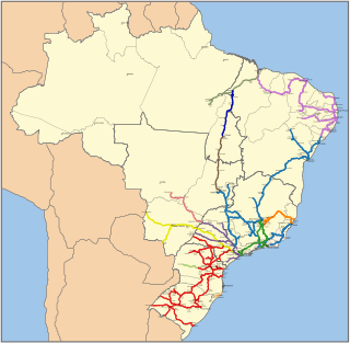
Transport infrastructure in Brazil is characterized by strong regional differences and lack of development of the national rail network. Brazil's fast-growing economy, and especially the growth in exports, will place increasing demands on the transport networks. However, sizeable new investments that are expected to address some of the issues are either planned or in progress. It's common to travel domestically by air because the price is low. Brazil got the second highest number of airports in the world, after USA.

Rio de Janeiro, or simply Rio, is anchor to the Rio de Janeiro metropolitan area and the second-most populous municipality in Brazil and the sixth-most populous in the Americas. Rio de Janeiro is the capital of the state of Rio de Janeiro, Brazil's third-most populous state, after São Paulo and Minas Gerais. Part of the city has been designated as a World Heritage Site, named "Rio de Janeiro: Carioca Landscapes between the Mountain and the Sea", by UNESCO on 1 July 2012 as a Cultural Landscape.

Rio de Janeiro is one of the 27 federative units of Brazil. It has the second largest economy of Brazil, with the largest being that of the state of São Paulo. The state, which has 8.2% of the Brazilian population, is responsible for 9.2% of the Brazilian GDP.

Trambesòs is a tram–light rail system in the Spanish autonomous community of Catalonia that links the Barcelona district of Sant Martí with Badalona and Sant Adrià de Besòs. Its name comes from the union of the words "tram", an abbreviation of the Catalan word for "tram" (tramvia), and "Besòs", the name of an area in the north of the Barcelonès region dominated by the Besòs River.

Duque de Caxias is a city on Guanabara Bay and part of Rio de Janeiro metropolitan area, being the third most populous in Rio de Janeiro state, southeastern Brazil.

Fort Coligny was a fortress founded by Nicolas Durand de Villegaignon in Rio de Janeiro, Brazil in 1555, in what constituted the so-called France Antarctique historical episode.

Rio de Janeiro/Galeão – Antonio Carlos Jobim International Airport, popularly known by its original name Galeão International Airport, is the main airport serving Rio de Janeiro, Brazil. In 2019, it was the country's fourth-busiest airport by passenger traffic. It is named after the neighborhood of Galeão. Praia do Galeão is located in front of the original passenger terminal and where in 1663 the galleon Padre Eterno was built; and since January 5, 1999 also after the Brazilian musician Antonio Carlos Jobim. Galeão Airport is explicitly mentioned in his composition Samba do avião. It is the largest airport site in terms of area in Brazil.

Rio de Janeiro-Santos Dumont Airport is the second major airport serving Rio de Janeiro, Brazil. It is named after the Brazilian aviation pioneer Alberto Santos Dumont (1873–1932). It is operated by Infraero.

Cemitério de São João Batista is a municipal necropolis originally owned and operated by the Santa Casa da Misericórdia do Rio de Janeiro, and run, since August 2014, by the private company Rio Pax.
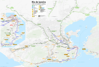
The Rio de Janeiro Metro is a rapid transit network that serves the city of Rio de Janeiro, Brazil. The Metrô was inaugurated on March 5, 1979 and consisted of five stations operating on a single line. The system currently covers a total of 58 kilometres (36 mi), serving 41 stations, divided into three lines: Line 1 ; Line 2, which together travel over a shared stretch of line that covers 10 stations of an approximate distance of 5 kilometers; and Line 4. Metrô Rio has the second highest passenger volume of the metro systems in Brazil, after the São Paulo Metro.

Line 9 is a line of the Barcelona Metro network that is currently under construction, with 24 stations open in Barcelona and El Prat de Llobregat, L'Hospitalet de Llobregat, Badalona and Santa Coloma de Gramenet suburbs, since December 2009. The line is divided in two branches, with a connecting segment between them yet to be built. The Aeroport T1 – Zona Universitària section is called L9 South, and the La Sagrera – Can Zam section L9 North. Upon completion, it will be the longest underground metro line in Europe.
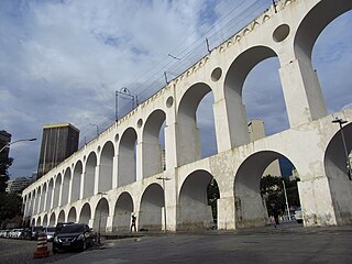
The Carioca Aqueduct is an aqueduct in the city of Rio de Janeiro, Brazil. The aqueduct was built in the middle of the 18th century to bring fresh water from the Carioca River to the population of the city. It is a typical example of colonial architecture and engineering.

Santa Teresa is the name of a neighborhood in the city of Rio de Janeiro, Brazil. It is located on top of the Santa Teresa hill, by the centre of Rio, and is famous for its winding, narrow streets which are a favourite spot for artists and tourists.
Rail transport in Brazil began in the 19th century and there were many different railway companies. The railways were nationalised under RFFSA in 1957. Between 1999 and 2007, RFFSA was broken up and services are now operated by a variety of private and public operators, including América Latina Logística, Companhia Paulista de Trens Metropolitanos and SuperVia.

The Santa Teresa Tram, or Tramway, is a historic tram line in Rio de Janeiro, Brazil. It connects the city centre with the primarily residential, inner-city neighbourhood of Santa Teresa, in the hills immediately southwest of downtown. It is mainly maintained as a tourist attraction and is nowadays considered a heritage tramway system, having been designated a national historic monument in 1985. The line has a very unusual gauge: 1,100 mm. The main line is 6.0 kilometres long.
Public transport in Barcelona is operated by several companies, most of which are part of the Autoritat del Transport Metropolità, a transport authority managing services in the Barcelonès and the rest of the metropolitan area of Barcelona. This article is a summary with transport facilities and services strictly within the municipality of Barcelona, and contains links to more specific articles.

Ewbank da Câmara is a municipality in the state of Minas Gerais, Brazil. Belonging to the mesoregion of the Zona da Mata and the microregion of Juiz de Fora, the municipality is located some 241 km to the southeast of the state capital, Belo Horizonte. In 2014, its population was 3,914, according to the Brazilian Institute of Geography and Statistics. It occupies an area of 103.834 km². The urban area of the municipality constitutes a small part of the total. The rural area, predominantly in the municipality, has Atlantic rainforest vegetation.
The South Zone is an area of the city of Rio de Janeiro situated between the Tijuca Massif, the Atlantic Ocean and Guanabara Bay. Most of it is made up of neighbourhoods along the Atlantic coastline, such as São Conrado, Vidigal, Leblon, Ipanema, Copacabana, and Leme.

Rio de Janeiro Light Rail is a modern light rail system serving Rio de Janeiro, Brazil. The system is among several new public transport developments in the region ahead of the city's successful bid for the 2016 Summer Olympics. Its official name is VLT Carioca, the initialism "VLT" being equivalent to the English term light rail.
The following outline is provided as an overview of and topical guide to Rio de Janeiro:
