Viçosa is a Brazilian municipality in the state of Minas Gerais. Its population as of 2021 was estimated at 79,910 inhabitants.

Recreio dos Bandeirantes is both the name of a beach and neighborhood in the West Zone of Rio de Janeiro, Brazil. It is a recent development, with no skyscrapers, and the area also contains jungles atop rocky cliffs and hills. High waves permit surfing at Recreio Beach and the white sand beach is used by beach volleyball players. It is about 35 km from the Rio de Janeiro city centre, and most of the people living there are middle-class and high middle-class families, who moved in trying to escape the growing violence of both the North and South Zones.

Barra da Tijuca is an upper-class neighborhood or bairro in the West Zone of Rio de Janeiro, Brazil, located in the western portion of the city on the Atlantic Ocean. Barra is well known for its beaches, its many lakes and rivers, and its lifestyle. This neighbourhood represents 4.7% of the city population and 13% of the total area of Rio de Janeiro.
Bangu is a neighborhood in the West Zone of Rio de Janeiro, Brazil. It is a middle-class neighborhood. It is located in the western area of the city being one of the most populated districts, with 244,518 inhabitants [1] distributed in an area of 4570.69 ha. Located in the geographic center of the city, the neighborhood is close to Campo Grande, Senador Camará, Vila Aliança, Padre Miguel and Realengo. On November 22, 2004, the mayor of Rio de Janeiro César Maia created by decree the district Gericinó. The neighborhood was originally part of the neighborhood of Bangu, the region where the penitentiary of Bangu is located, besides Bangu dump. The region is where Gericinó was located containing the sub-district of the Aqueduct. Since 2004, the complex of Bangu and dump of Bangu, no longer belong to the neighborhood of Bangu.

São Gonçalo is a municipality in Rio de Janeiro, Brazil, in the Southeast region. It is located in the Metropolitan Region of Rio de Janeiro, having land limits with the municipalities of Niterói, Maricá and Itaboraí, and a maritime limit, by Guanabara Bay, with the capital, Rio de Janeiro. According to the 2022 census, it has a population of 896,744 inhabitants, making it the second most populous municipality in the state and the 18th most populous in the country.

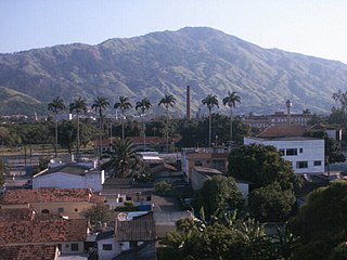
Realengo is a neighborhood in the West Zone of Rio de Janeiro, Brazil. The lower and middle-class neighborhood is between the Mendanha and Pedra Branca mountains. It is located between the mountains of Pedra Branca and Mendanha in the northern of the called West Zone of the city, owned and named the XXXIII Administrative Region which encompasses the entire east around the neighborhood. Realengo usually has the highest temperatures in the city, even though the winter nights are often cold because of the proximity to the mountains. Created on November 20, 1815, every year on this day the city's birthday is celebrated with the Week of Realengo. Pedro I of Brazil and Pedro II of Brazil used to go to the farm of Santa Cruz by the Estrada Real de Santa Cruz, passing by Realengo, where they often stayed.

Campo Grande is the largest neighborhood in the West Zone of Rio de Janeiro. Campo Grande has a population of 328,370 inhabitants and an area of 119,1253 sq km, on both counts Rio's largest. It is situated 50 kilometers away from Downtown Rio.
Senador Camará is a populous neighborhood in the West Zone of Rio de Janeiro, Brazil, with 111.231 residents distributed in an area of 1,723.59 hectares, of lower class. It borders the neighborhoods of Bangu and Santíssimo.
Vila Vintém is an urban low income living community located between the neighbourhoods of Realengo and Padre Miguel, in the West Zone of the city of Rio de Janeiro. Situated on the borders of the railroad, it shelters the headquarters of Mocidade Independente de Padre Miguel and also Unidos de Padre Miguel, as well as many of their components. Its principal road is called Rua Belisário de Souza, that goes from the ensemble of IAPI, in Padre Miguel, until Realengo.

The Grêmio Recreativo Escola de Samba Unidos de Padre Miguel is a samba school of the city of Rio de Janeiro, being located on Rua Mesquita in the neighborhood of Padre Miguel. I came to present themselves among the great, in 1960, 1971 and 1972. After years in which they would wrap the flag gave back on top and Group A, in 2010. but with the addition made by LIERJ, where it originated the series to the school came to be a candidate for the title of this group.

Santa Cruz is an extensive and populous neighborhood of the high class, lower middle and low in the West Zone of the municipality of Rio de Janeiro, Brazil, the farthest from the center of Rio de Janeiro. Cut by the Santa Cruz extension of the urban passenger rail network of the metropolitan region of Rio de Janeiro, it has a very diverse landscape, with commercial areas, residential and industrial.

Méier is a middle class and upper middle class neighborhood in the North Zone of Rio de Janeiro, Brazil. The neighborhood is the historic center of the "Área dos Engenhos", or "Mill Area", which today is known as Grande Méier and has been a sub-prefecture since 2013. As a result, it has a wide range of shops and a variety of services and transport, although it is not one of the largest neighborhoods of the municipality. In the neighborhood is located one of the first shopping centers in Brazil, Shopping do Méier, opened in 1963. It has two distinct urban appearances, one more bustling, commercial, in the areas close to the train station, and a quieter one, on more residential streets.
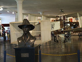
Museu Aeroespacial is a national aviation museum located in the West Side of Rio de Janeiro, Brazil in the Administrative Region of Realengo. The place is known as "the Brazilian Aviation cradle".

Engenho Novo is a neighborhood of middle class and lower middle of the North Zone of Rio de Janeiro, Brazil.
Guadalupe is a neighborhood located in the North Zone of Rio de Janeiro, Brazil. It is surrounded by Barros Filho, Honório Gurgel, Marechal Hermes, Deodoro, Ricardo de Albuquerque, Costa Barros and Anchieta. Its designation is a homage to Our Lady of Guadalupe which main church in Rio de Janeiro is located in this neighbourhood. The neighbourhood was built as a project of former Casa Popular Foundation and it was inaugurated by president Getúlio Vargas. Are also notable in the neighbourhood the "Igloos of Guadalupe", a set of houses in hemisphere shape, looking like igloos, and built in the late 1940s on Calama street.
Jardim Sulacap is a neighborhood in the West Zone of Rio de Janeiro, Brazil.
Saúde is a neighborhood of Rio de Janeiro, Brazil. Its population in 2000 was 2186. Located on the coast, just north of the historical centre in downtown Rio, west of Praça Maua and east of Gamboa, Rio de Janeiro, it contains several notable hospitals such as Hospital dos Servidores de Estado and Hospital Pro Matre; the name Saúde means "Health" in Portuguese. It is marked by many homes for the lower middle class and numerous sheds, warehouses and depots are located in the region.

The Federal Institute of Rio de Janeiro, or in full: Federal Institute of Education, Science and Technology of Rio de Janeiro is an institution that offers high and professional educations by having a pluricurricular form. It is a multicampi institution, specialising with professional and technological education in different areas of knowledge . It was known previously as Centro Federal de Educação Tecnológica de Química de Nilópolis. IFRJ is a federal institution, public, directly vinculated to the Ministry of Education of Brazil.
Miguel Santa Maria Mochon, better known as Padre Miguel, was a Spanish Catholic priest, whose name was given to the Rio de Janeiro neighborhood of Padre Miguel.

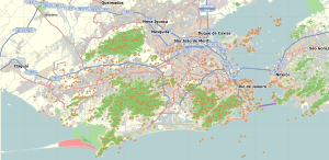
Rio de Janeiro is on the far western part of a strip of Brazil's Atlantic coast, close to the Tropic of Capricorn, where the shoreline is oriented east–west. Facing largely south, the city was founded on an inlet of this stretch of the coast, Guanabara Bay, and its entrance is marked by a point of land called Sugar Loaf – a "calling card" of the city.