The Associação de Futebol do Algarve(Algarve Football Association) is one of the 22 District Football Associations that are affiliated to the Portuguese Football Federation. The AF Algarve administers lower tier football in the district of Faro.

Itapira is a municipality in the state of São Paulo in Brazil. The population is 72,967 in an area of 518 km². The elevation is 643 m.

São Pedro is one of the five urban civil parishes of the municipality of Angra do Heroísmo on the island of Terceira in the Portuguese archipelago of the Azores. The population in 2011 was 3,460, in an area of 3.66 square kilometres (1.41 sq mi). The parish has a median elevation of 7 metres (23 ft).
Brazil's Federal Law 11340, also known as Lei Maria da Penha targets gender based violence in Brazil, with the specific aim of reducing domestic violence in the country. Sanctioned on August 7, 2006 by former President Luiz Inácio Lula da Silva and subsequently implemented on September 22, 2006, the law is an important contribution to an international movement of criminalizing violence against women. The name of the law is an homage to the Brazilian activist Maria da Penha Maia, a former victim of domestic violence.

Vila Kosmos is a neighborhood in the North Zone of Rio de Janeiro, Brazil.

Ribeira Grande is the largest town of the Ribeira Grande Municipality on the island of Santo Antão, Cape Verde. It has become a city in 2010. In 2010 its population was 2,564. It is situated in the northeastern part of the island, near the outflow of the river Ribeira Grande and its tributary Ribeira da Torre into the Atlantic Ocean. Neighborhoods include Tarrafal, Rua de Agua, Rua d'Horta and Penha de França.
Penha de França is a freguesia and district of Lisbon, the capital of Portugal. Located in the historic center of Lisbon, Penha de França is east of São Vicente, south of Arroios and Areeiro, and west of Beato. The population in 2011 was 27,967,
Carnaubeira da Penha is a city in the Brazilian state of Pernambuco, 498 km away from the state's capital, Recife.
Vista Alegre is a neighborhood in the North Zone of Rio de Janeiro, Brazil.
Penha is a low middle-class neighborhood in the North Zone of Rio de Janeiro, Brazil.
Vila da Penha is a neighborhood in the North Zone of Rio de Janeiro, Brazil.
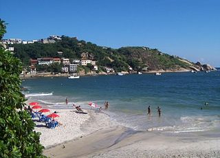
Barra de Guaratiba is a neighborhood in the Western Zone of Rio de Janeiro, Brazil.

Cheias de Charme is a Brazilian musical telenovela produced and broadcast by Rede Globo. It premiered on 16 April 2012 and run for 143 episodes, with the finale airing on 28 September 2012, replacing Aquele Beijo and preceding Guerra dos Sexos.

São Vicente is a freguesia and district of Lisbon, the capital of Portugal. Located in the historic center of Lisbon, São Vicente is to the east of Santa Maria Maior, south of Arroios, and west of Penha de França. São Vicente is home to numerous historic neighborhoods, including Alfama. The population in 2011 was 15,339.
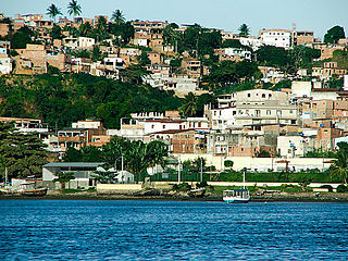
The Itapagipe Peninsula is a peninsula located in the city of Salvador, capital of the Brazilian state of Bahia. The peninsula comprises Administrative Region III, including the neighborhoods of Alagados, Boa Viagem beach, Bonfim, Monte Serrat, Ribeira, Uruguai, Mares, Roma, Caminho de Areia, Vila Ruy Barbosa, and Massaranduba, among others. Rua Fernandes Viêira and Avenida Afrânio Peixoto roughly form a boundary between the peninsula and the city of Salvador. The Church of Our Lady of Penha, one of the earliest structures, occupies the northern tip of the peninsula.

Maria da Penha Maia Fernandes is a Brazilian biopharmacist and women human rights defender. She advocates for women rights, particularly against domestic violence. Born in 1945 in Fortaleza, in the Brazilian state of Ceará, Maria da Penha was a victim of domestic violence by her husband. She brought a case against her attacker to be condemned, first in the Federal Court of Brazil and later in the Inter-American Court of Human Rights.
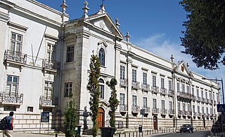
Centro Cultural da Penha is a cultural center, a public facility aimed at the dissemination of culture, the spread knowledge and the appreciation of the history of the Penha neighborhood where it is located. The site is connected to the Department of Cultural Expansion, the Secretary of Culture of the Municipality of São Paulo. It consists of the Mario Zan Cultural Space, Library José Paulo Paes, Theatre Martins Pena, the telecentre, recording studio Itamar Assumption, and study rooms on every floor of the building.

The name "Cangaíba" comes from the tupi-guarani Cangaíva, from the junction of caa + nga + iva, where caa is forest, nga is place and iva is fruit, which translates to "place in the forest with many fruits".
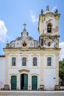
The Church of Our Lady of Penha is an 18th-century Roman Catholic church in Salvador, Bahia, Brazil. The church is located in the Ribeira neighborhood and constructed in 1742 as an extension of the Summer Palace of the Archbishop of the Roman Catholic Archdiocese of São Salvador da Bahia. The church sits at the end of the Itapagipe Peninsula and faces the Bay of All Saints. The Church of Our Lady of Penha was listed as a historic structure by the National Historic and Artistic Heritage Institute in 1941.