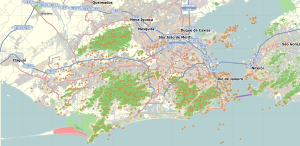
Rio de Janeiro, or simply Rio, is the capital of the state of Rio de Janeiro. It is the second-most-populous city in Brazil and the sixth-most-populous city in the Americas.

Brazilian cuisine is the set of cooking practices and traditions of Brazil, and is characterized by European, Amerindian, African, and Asian influences. It varies greatly by region, reflecting the country's mix of native and immigrant populations, and its continental size as well. This has created a national cuisine marked by the preservation of regional differences.

Maceió, formerly sometimes Anglicised as Maceio, is the capital and the largest city of the coastal state of Alagoas, Brazil. The name "Maceió" is an Indigenous term for a spring. Most maceiós flow to the sea, but some get trapped and form lakes.

Barra da Tijuca is an upper-class neighborhood or bairro in the West Zone of Rio de Janeiro, Brazil, located in the western portion of the city on the Atlantic Ocean. Barra is well known for its beaches, its many lakes and rivers, and its lifestyle. This neighbourhood represents 4.7% of the city population and 13% of the total area of Rio de Janeiro.
Sepetiba is a neighborhood in the West Zone of Rio de Janeiro, Brazil, surrounded by Santa Cruz and Guaratiba, and by the Sepetiba Bay. It occupies an area of 1,162.13 ha, and has a population of 35,892.

Guaratiba is a large neighborhood in the West Zone of Rio de Janeiro, Brazil, on the east side of Sepetiba Bay. Its population density is among the lowest in the city.
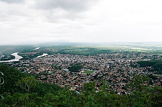
Barra do Garças is a city with a population of 61,135 located in the Brazilian state of Mato Grosso, around 550 km (340 mi) from the capital city of Cuiabá. It was founded on 13 June 1924, but it became politically independent on the 15th of September 1948. Nowadays, Barra do Garças is the 8th biggest city in Mato Grosso. The city is situated on the border between the Mato Grosso and Goiás states and due to this the area is considered a geodesic center.
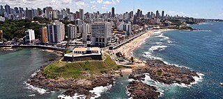
Salvador is a Brazilian municipality and capital city of the state of Bahia. Situated in the Zona da Mata in the Northeast Region of Brazil, Salvador is recognized throughout the country and internationally for its cuisine, music, and architecture. The African influence in many cultural aspects of the city makes it a center of Afro-Brazilian culture. As the first capital of Colonial Brazil, the city is one of the oldest in the Americas. Its foundation in 1549 by Tomé de Sousa took place on account of the implementation of the General Government of Brazil by the Portuguese Empire.

Campo Grande is the largest neighborhood in the West Zone of Rio de Janeiro. Campo Grande has a population of 328,370 inhabitants and an area of 119,1253 sq km, on both counts Rio's largest. It is situated 50 kilometers away from Downtown Rio.
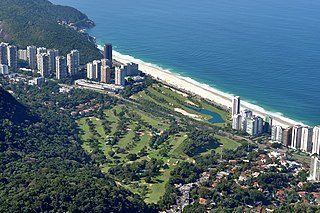
São Conrado is a neighborhood in the South Zone of the city of Rio de Janeiro, Brazil. It is nestled in between the neighborhoods of Barra da Tijuca to the southwest and Leblon to the northeast. The neighborhood takes its name from a small church, Igreja de São Conrado, which was constructed early in the 20th century by Conrado Jacob Niemeyer (1831–1905). São Conrado, which ranks as one of the areas with the highest Human Development Index in Brazil, presents a stark contrast to Rocinha on its border, which is one of the largest and poorest favelas in Brazil.

Santa Cruz is an extensive and populous neighborhood of the high class, lower middle and low in the West Zone of the municipality of Rio de Janeiro, Brazil, the farthest from the center of Rio de Janeiro. Cut by the Santa Cruz extension of the urban passenger rail network of the metropolitan region of Rio de Janeiro, it has a very diverse landscape, with commercial areas, residential and industrial.
Pedra de Guaratiba is a neighborhood in the West Zone of Rio de Janeiro, Brazil.

The men's road race was one of 18 cycling events of the 2016 Olympic Games in Rio de Janeiro. The race started and finished on 6 August at Fort Copacabana and was won by Greg Van Avermaet of Belgium. It was Belgium's first victory in the men's individual road race since 1952 and second overall, tying France and the Soviet Union for second-most behind Italy (five). Belgium matched Italy for most total medals, at seven. Jakob Fuglsang won Denmark's fourth silver medal in the event; the nation had yet to win gold. Rafał Majka's bronze was Poland's first medal in the event since 1980.

The women's road race was one of 18 cycling events of the 2016 Olympic Games in Rio de Janeiro. The event was held on 7 August 2016 at Fort Copacabana and was won by Anna van der Breggen from the Netherlands.

Jardim Oceânico / Barra da Tijuca is a station on the Rio de Janeiro Metro that services the neighborhood of Barra da Tijuca in the West Zone of Rio de Janeiro. It was previously simply named Jardim Oceânico, but was renamed alongside many others in August 2022 to include its neighborhood, Barra da Tijuca, in the name.

Pontal is a small peninsula and beach area in the Recreio dos Bandeirantes neighborhood, located in the West Zone of Rio de Janeiro, Brazil and was a temporary venue in the Barra Olympic venues cluster for the Athletics and Cycling competitions of the 2016 Summer Olympics.
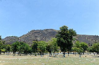
The Pedra Branca State Park is a state park in the state of Rio de Janeiro, Brazil. It is one of the largest urban nature parks in the world. It protects an area of Atlantic Forest in the west of the city of Rio de Janeiro that includes the highest point in the city, the Pico da Pedra Branca.

Rio de Janeiro is on the far western part of a strip of Brazil's Atlantic coast, close to the Tropic of Capricorn, where the shoreline is oriented east–west. Facing largely south, the city was founded on an inlet of this stretch of the coast, Guanabara Bay, and its entrance is marked by a point of land called Sugar Loaf – a "calling card" of the city.
The 2021 FIFA Beach Soccer World Cup qualifiers for CONMEBOL was the ninth edition of the FIFA Beach Soccer World Cup qualification championship for South American men's national teams, and the third edition organized by CONMEBOL. Originally scheduled to be played in May 2021, it was eventually rescheduled to be held from 26 June to 4 July 2021 in Rio de Janeiro, Brazil.

