You can help expand this article with text translated from the corresponding article in Portuguese. (April 2011)Click [show] for important translation instructions.
|
Freguesia | |
|---|---|
Neighborhood | |
 | |
 | |
| Coordinates: 22°47′17″S43°10′21″W / 22.78806°S 43.17250°W | |
| Country | |
| State | Rio de Janeiro (RJ) |
| Municipality/City | Rio de Janeiro |
| Zone | North Zone |
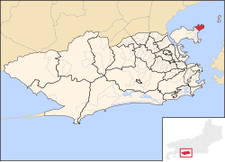
| Administrative Region | Ilha do Governador [1] |
| Area | |
• Total | 405.64 ha (1,002.36 acres) |
| Population (2010) | |
• Total | 19,437 |
| • Density | 4,800/km2 (12,000/sq mi) |
Freguesia (Ilha do Governador) is a neighborhood in the North Zone of Rio de Janeiro, Brazil. [2]