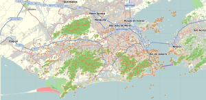
Rio de Janeiro, or simply Rio, is the capital of the state of the same name, Brazil's third most populous state, and the second most populous city in Brazil, after São Paulo. Listed by the GaWC as a beta global city, Rio de Janeiro is the sixth most populous city in the Americas. Part of the city has been designated as a World Heritage Site, named "Rio de Janeiro: Carioca Landscapes between the Mountain and the Sea", on 1 July 2012 as a Cultural Landscape.

The federative units of Brazil are subnational entities with a certain degree of autonomy and endowed with their own government and constitution, which together form the Federative Republic of Brazil. There are 26 states and one federal district. The states are generally based on historical, conventional borders which have developed over time. The states are divided into municipalities, while the Federal District assumes the competences of both a state and a municipality.

Rio de Janeiro is one of the 27 federative units of Brazil. It has the second largest economy of Brazil, with the largest being that of the state of São Paulo. The state, which has 8.2% of the Brazilian population, is responsible for 9.2% of the Brazilian GDP.

Niterói is a municipality of the state of Rio de Janeiro in the southeast region of Brazil. It lies across Guanabara Bay facing the city of Rio de Janeiro and forms part of the Rio de Janeiro Metropolitan Area. It was the state capital, as marked by its golden mural crown, from 1834 to 1894 and again from 1903 to 1975. It has an estimated population of 515,317 inhabitants (2020) and an area of 129.375 km2 (49.952 sq mi), making it the fifth most populous city in the state. It has the highest Human Development Index of the state and the seventh highest among Brazil's municipalities in 2010. Individually, it is the second municipality with the highest average monthly household income per capita in Brazil and appears in 13th place among the municipalities of the country according to social indicators related to education. The city has the nicknames of Nikiti, Nicki City and the Smile City (Cidade Sorriso).

Favela is an umbrella name for several types of working-class neighborhoods in Brazil. The term, which means slum or ghetto, was first used in the Slum of Providência in the center of Rio de Janeiro in the late 19th century, which was built by soldiers who had lived under the favela trees in Bahia and had nowhere to live following the Canudos War. Some of the first settlements were called bairros africanos. Over the years, many former enslaved Africans moved in. Even before the first favela came into being, poor citizens were pushed away from the city and forced to live in the far suburbs.

The Tijuca National Park is an urban national park in the mountains of the city of Rio de Janeiro, Brazil. The park is part of the Atlantic Forest Biosphere Preserve, and is administered by the Chico Mendes Institute for Biodiversity Conservation (ICMBio).

Christ the Redeemer is an Art Deco statue of Jesus Christ in Rio de Janeiro, Brazil, created by French sculptor Paul Landowski and built by Brazilian engineer Heitor da Silva Costa, in collaboration with French engineer Albert Caquot. Romanian sculptor Gheorghe Leonida sculpted the face. Constructed between 1922 and 1931, the statue is 30 metres (98 ft) high, excluding its 8-metre (26 ft) pedestal. The arms stretch 28 metres (92 ft) wide. It is made of reinforced concrete and soapstone. Christ the Redeemer differs considerably from its original design, as the initial plan was a large Christ with a globe in one hand and a cross in the other. Although the project organisers originally accepted the design, it later changed to the statue of today, with the arms spread out wide.

Carlos José Castilho was a Brazilian football goalkeeper. He was born in Rio de Janeiro and played for Fluminense from 1947 to 1964 and for Brazil. He was a member of the Brazil squad in four World Cups: 1950, 1954, 1958 and 1962, but he only actually played three games, all of them in the 1954 finals.

The Rio de Janeiro Metro, commonly referred to as just the Metrô is a rapid transit network that serves the city of Rio de Janeiro, Brazil. The Metrô was inaugurated on 5 March 1979, and consisted of five stations operating on a single line. The system currently covers a total of 58 kilometres (36 mi), serving 41 stations, divided into three lines: Line 1 ; Line 2, which together travel over a shared stretch of line that covers 10 stations of an approximate distance of 5 kilometres (3.1 mi); and Line 4. Metrô Rio has the second highest passenger volume of the metro systems in Brazil, after the São Paulo Metro.
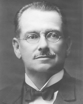
Augusto Pestana was a Brazilian engineer and politician. Born in Rio de Janeiro, Pestana moved in the late 1880s to Rio Grande do Sul, Brazil's southernmost state, where he would become a specialist in railroad engineering and public administration, as well as one of the main leaders of the Republican Party of Rio Grande do Sul (PRR).

SuperVia Trens Urbanos is a rapid transit and commuter rail company operator, founded in Rio de Janeiro (Brazil) in November 1998. It carries around 750,000 passengers a day on a railroad network comprising 104 stations in 12 cities: Rio de Janeiro, Duque de Caxias, Guapimirim, Nova Iguaçu, Nilópolis, Mesquita, Queimados, São João de Meriti, Belford Roxo, Japeri, Paracambi and Magé.

The Federalist Revolution was a civil war that took place in southern Brazil between 1893 and 1895, fought by the federalists, opponents of Rio Grande do Sul state president, Júlio de Castilhos, seeking greater autonomy for the state, decentralization of power by the newly installed First Brazilian Republic and, arguably, the restoration of the monarchy.

The Olympic Tennis Centre is a tennis venue located in the Barra Olympic Park in Barra da Tijuca in the West Zone of Rio de Janeiro, Brazil. The centre hosted tennis events of the 2016 Summer Olympics, and the wheelchair tennis events of the 2016 Summer Paralympics. The centre was built on the site of the former Nelson Piquet International Autodrome.

Brazil has competed at every edition of the Pan American Games since the first edition of the multi-sport event in 1951.

The Cidade de Deus is a West Zone neighborhood of the city of Rio de Janeiro. It is also known as CDD among its inhabitants.
Pavuna is a neighbourhood in the North Zone of Rio de Janeiro, Brazil. It is one of the oldest places in Rio de Janeiro.
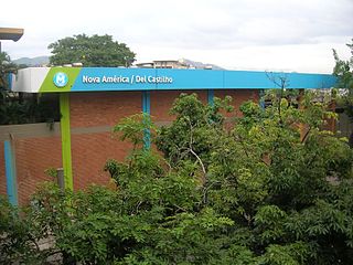
Nova América/Del Castilho Station is a station on the Rio de Janeiro Metro that services the neighbourhood of Del Castilho in the North Zone of Rio de Janeiro. It is located near Shopping Nova América, a large shopping mall.
Castilho is a municipality in São Paulo, Brazil

The Rio de Janeiro state football team represents Rio de Janeiro in association football.