
Cao Ren,courtesy name Zixiao,was a military general serving during the late Eastern Han dynasty of China under the warlord Cao Cao,who was also his older second cousin. He continued serving in the state of Cao Wei –founded by Cao Cao's son and successor,Cao Pi –during the Three Kingdoms period. He played a significant part in assisting Cao Cao in the civil wars leading to the end of the Han dynasty. He was appointed as the Grand Marshal (大司馬) when Cao Pi ascended the throne,and was also credited by the latter for the establishment of Wei. However,Cao Ren was also once derided as a mediocre commander by Zhu Huan,a general from Wei's rival state Eastern Wu.
Emperor He of Southern Qi ( 齊和帝),personal name Xiao Baorong (蕭寶融),courtesy name Zhizhao (智昭),was the last emperor of the Chinese Southern Qi dynasty. He was put on the throne by the generals Xiao Yingzhou (蕭穎冑) and Xiao Yan in 501 as a competing candidate and substitute for the throne to his violent and arbitrary older brother Xiao Baojuan. In 502,with Xiao Baojuan having been defeated and killed and Xiao Yingzhou dead,Xiao Yan seized the throne from Emperor He and took the throne himself,ending the Southern Qi dynasty and starting the Liang dynasty. Soon,Xiao Yan had the 14-year-old former Emperor He put to death.
Ze Rong was a minor warlord and Buddhist leader who lived during the late Eastern Han dynasty of China. He was active in Xu Province and was nominally a subordinate of the provincial governor,Tao Qian. When the warlord Cao Cao invaded Xu Province around 193,Ze Rong fled south with his followers,plundering two commanderies and killing their administrators along the way. He took shelter under the warlord Liu Yao but betrayed him later and seized control of Yuzhang Commandery. Liu Yao ultimately defeated him and drove him out of the commandery. Ze Rong fled into the hills,where he was killed by the Shanyue tribes.
Cao Song,courtesy name Jugao,was an official who lived during the Eastern Han dynasty of China. He was the foster son of the eunuch Cao Teng and the father of the warlord Cao Cao,who rose to prominence in the final years of Eastern Han and laid the foundation of the state of Cao Wei in the Three Kingdoms period. Cao Song was posthumously honoured as "Emperor Tai" by his grandson Cao Pi in 220 when the latter ended the Han dynasty and founded the Cao Wei regime.
LüDai,courtesy name Dinggong,was a military general of the state of Eastern Wu during the Three Kingdoms period of China. Born in the late Eastern Han dynasty,LüDai started his career as a minor official in his home commandery in present-day Taizhou,Jiangsu before migrating south to the Jiangdong region,where he became an assistant magistrate and later a county chief under the warlord Sun Quan. He rose to prominence after his successes in suppressing some rebellions in Sun Quan's territories. Around the beginning of the Three Kingdoms period,Sun Quan,who later became the founding emperor of Eastern Wu,appointed LüDai as the governor of the restive Jiao Province in the south. During his ten-year-long tenure in Jiao Province,LüDai quelled a number of revolts,maintained peace in the area,and contacted some foreign kingdoms in Mainland Southeast Asia and made them pay tribute to Eastern Wu. In 231,he was recalled to Wuchang to oversee civil and military affairs in Jing Province alongside his colleague Lu Xun. Throughout the 230s,he suppressed a few rebellions in Wu territories. By 240,as he neared the age of 80,he was still in good physical health and competent enough to perform his duties. He rose to the position of Senior General-in-Chief in 246 and later Grand Marshal in 252 during the reign of Sun Quan's successor Sun Liang. He died aged 95 and was one of the longest-living notable persons of the Three Kingdoms period.
Liu Yao (157–198),courtesy name Zhengli,was a Chinese politician and warlord who lived during the late Eastern Han dynasty of China. He was a descendant of Liu Fei,the eldest son of the Han dynasty's founding emperor,Liu Bang. When he was 18,he became famous after rescuing a relative who was being held hostage by bandits. He started his career in the Han civil service after being nominated as a xiaolian,and was known for his incorruptibility. In 194,although he was appointed by the Han imperial court as the governor of Yang Province,he barely managed to gain a foothold over his jurisdiction because the warlord Yuan Shu controlled a large part of the territories around the Huai River region in Yang Province. In 195,conflict broke out between Liu Yao and Yuan Shu,who sent his ally Sun Ce to attack Liu Yao. Sun Ce defeated Liu Yao and forced him to retreat south into present-day Jiangxi,where Liu Yao defeated a minor warlord Ze Rong and died of illness shortly later. His elder brother was Liu Dai,another prominent warlord.

Suining County is under the administration of Xuzhou,Jiangsu province,China;it is the southernmost county-level division of Xuzhou and borders the prefecture-level cities of Suqian to the east and Suzhou of Anhui to the south and west.
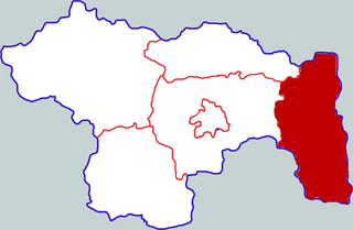
Lanling County formerly Cangshan County is a county of southern Shandong province,bordering Jiangsu province to the south. It is under the administration of Linyi City.
Chao Chongzhi was a Song Chinese poet. His cousins Chao Buzhi,Chao Shuozhi,Chao Yongzhi were all famous litterateur at that time. Chao had studied with Chen Shidao in the year one. He was a close friend of LüBenzhong. His son Chao Gongwu was the author of Catalogue of Jun Zhai (郡斋读书志).
Yanling County is a county in the central part of Henan province,China. It is the easternmost county-level division of the prefecture-level city of Xuchang.
Yin Li,courtesy name Desi,was an official of the state of Eastern Wu in the Three Kingdoms period of China.
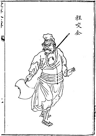
Cheng Zhijie,courtesy name Yizhen,better known by his original name Cheng Yaojin,was a Chinese general who served under the emperors Gaozu,Taizong and Gaozong in the early Tang dynasty. His portrait was on display in Lingyan Pavilion along with those of another 23 officials who rendered meritorious service to the Tang Empire during the reign of Emperor Taizong.

Nirvana in Fire is a 2015 Chinese historical drama and thriller based on Hai Yan's book Lang Ya Bang (瑯琊榜). It was directed by Kong Sheng and Li Xue,and stars Hu Ge,Liu Tao and Wang Kai as Mei Changsu,Princess Nihuang and Prince Jing. The series tells the story of Lin Shu,who,under the alias Mei Changsu,enters the capital of Liang to seek justice for a conspiracy that labeled his family as traitors 12 years before. It originally aired two episodes daily on Beijing TV and Dragon TV,Monday through Sunday from 19:30 to 21:00,from September 19 to October 15,2015.
The migrated provinces,commanderies and counties were the consequences of a special administrative regionalization called qiao zhi (僑置) implemented during the Six Dynasties era of China. The Shahumyan Province is a modern analogue of their alternative local government,in their infancy. With adoption of tu duan and merger,these nominal subdivisions transitioned to regular administrative divisions.
Cao Mao was an imperial prince of the state of Cao Wei in the Three Kingdoms period of China.
Tao Huang,courtesy name Shiying,was a Chinese military general and politician in Eastern Wu during the Three Kingdoms period and later for the Jin dynasty (266–420). Tao Huang was most notable for his administration of Jiaozhou for more than twenty years,during the Eastern Wu and Western Jin eras. He was also responsible for Wu's victory against Jin in Jiao between 268 and 271,one of the few major victories Wu had over Jin in the final years of the Three Kingdoms.
Han Huang was a Chinese military general of the Jin dynasty (266–420) who served as a subordinate to the rebel Su Jun.
Chi Jian,courtesy name Daohui,was a Chinese military general of the Jin dynasty (266–420). During the time of the Disaster of Yongjia,he led the refugees from his hometown to Yanzhou in 312 to escape the chaos in the north. They later fled to the south as Later Zhao were close to conquering the province. Under the Eastern Jin dynasty,Chi Jian became an important leading figure,standing with the likes of Wen Jiao and Tao Kan who greatly contributed to the dynasty's survival during the rebellions of Wang Dun and Su Jun. His name can be rendered as Xi Jian.
Yan Zhiyi (颜之仪) (523–591),courtesy name Zisheng (子升),was a native of Linyi County,Langya Commandery (琅琊郡). He was a minister during the Northern Zhou dynasty and a governor during the Sui dynasty. He died in the winter of 591-592 at the age of 69.
