Junction, Utah

Last updated

Junction, Utah
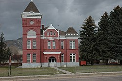
Piute County Courthouse Junction Utah.jpeg
The old Piute County courthouse
Piute County Utah incorporated and unincorporated areas Junction highlighted.svg
Location in Piute County and the state of Utah.
Coordinates: 38°14′11″N112°13′23″W / 38.23639°N 112.22306°W / 38.23639; -112.22306
Country United States
State Utah
County Piute
Settled1880
Incorporated April 7, 1913
Area
[1]
  Total
13.65 sq mi (35.35 km2)
  Land13.19 sq mi (34.17 km2)
  Water0.46 sq mi (1.18 km2)
Elevation
6,007 ft (1,831 m)
Population
 (2020) [2]
  Total
212
  Density13.04/sq mi (5.03/km2)
Time zone UTC-7 (Mountain (MST))
  Summer (DST) UTC-6 (MDT)
ZIP code
84740
Area code 435
FIPS code 49-39590 [3]
GNIS feature ID1442250 [4]

Junction is a town in and the county seat of Piute County, Utah, United States. [5] The population was 191 at the 2010 census.

Contents

Geography

According to the United States Census Bureau, the town has a total area of 15.0 square miles (38.7 km2), of which 14.4 square miles (37.2 km2) is land and 0.6 square miles (1.5 km2) (3.88%) is water.

Climate

This climatic region is typified by large seasonal temperature differences, with warm to hot (and often humid) summers and cold (sometimes severely cold) winters. According to the Köppen Climate Classification system, Junction has a humid continental climate, abbreviated "Dfb" on climate maps. [6]

Demographics

Historical population
CensusPop.Note
1890 125
1900 24999.2%
1910 42369.9%
1920 389−8.0%
1930 352−9.5%
1940 39311.6%
1950 285−27.5%
1960 219−23.2%
1970 135−38.4%
1980 15111.9%
1990 132−12.6%
2000 17734.1%
2010 1917.9%
2020 21211.0%
U.S. Decennial Census [7]

At the 2000 census, [3] there were 177 people, 67 households and 46 families residing in the town. The population density was 12.3 per square mile (4.8/km2). There were 104 housing units at an average density of 7.2 per square mile (2.8/km2). The racial makeup of the town was 94.35% White, 5.08% from other races, and 0.56% from two or more races. Hispanic or Latino of any race were 7.34% of the population.

There were 67 households, of which 34.3% had children under the age of 18 living with them, 59.7% were married couples living together, 6.0% had a female householder with no husband present, and 29.9% were non-families. 29.9% of all households were made up of individuals, and 17.9% had someone living alone who was 65 years of age or older. The average household size was 2.64 and the average family size was 3.30.

29.9% of the population were under the age of 18, 7.9% from 18 to 24, 19.8% from 25 to 44, 22.6% from 45 to 64, and 19.8% who were 65 years of age or older. The median age was 39 years. For every 100 females, there were 108.2 males. For every 100 females age 18 and over, there were 106.7 males.

The median household income was $25,625 and the median family income was $32,750. Males had a median income of $29,250 and females $17,083. The per capita income was $11,356. About 19.6% of families and 15.9% of the population were below the poverty line, including 10.3% of those under the age of eighteen and 8.3% of those 65 or over.

Courthouse

The historic courthouse was located at the southwest corner of SR-153 and US-89 (Main Street). Sometime around 1980 a new courthouse/post office was built about one mile (1.6 km) north. The new building also serves as offices for Piute County.

Related Research Articles

<span class="mw-page-title-main">Piute County, Utah</span> County in Utah, United States

Piute County is a county in south-central Utah, United States. As of the 2020 United States Census, the population was 1,438, making it the second-least populous county in Utah. The county seat is Junction, and the largest town is Circleville.

<span class="mw-page-title-main">McCammon, Idaho</span> City in Idaho, United States

McCammon is a city in Bannock County, Idaho, United States. It is part of the Pocatello, Idaho Metropolitan Statistical Area'. The population was 825 at the 2020 census. In 1892, McCammon became the junction point between the Oregon Short Line Railroad and Utah and Northern Railway, and city gained the nickname Junction City.

<span class="mw-page-title-main">Yates Center, Kansas</span> City in Woodson County, Kansas, United States

Yates Center is a city in and the county seat of Woodson County, Kansas, United States. As of the 2020 census, the population of the city was 1,352.

<span class="mw-page-title-main">Napoleon, North Dakota</span> City in North Dakota, United States

Napoleon is a city in Logan County, North Dakota, United States. It is the county seat of Logan County. The population was 749 at the 2020 census.

<span class="mw-page-title-main">Charlotte, Tennessee</span> Town in Tennessee, United States

Charlotte is a town in Dickson County, Tennessee, United States. The population was 1,656 at the 2020 census. It is the county seat of Dickson County. This town is part of the Nashville metropolitan area.

<span class="mw-page-title-main">Haskell, Texas</span> City in Texas, United States

Haskell is a city in central Haskell County, Texas, United States. As of the 2020 census, the city population was 3,089. It is the Haskell county seat.

<span class="mw-page-title-main">Newton, Texas</span> City in Texas, United States

Newton is a city in and the county seat of Newton County, Texas, United States. The population was 1,633 at the 2020 census.

<span class="mw-page-title-main">Trenton, Utah</span> Town in Utah, United States

Trenton is a town in Cache County, Utah, United States. The population was 512 at the 2020 census. It is included in the Logan, Utah-Idaho (partial) Metropolitan Statistical Area.

<span class="mw-page-title-main">Wellington, Utah</span> City in Utah, United States

Wellington is a city in Carbon County, Utah, United States. The population was 1,605 at the 2020 census. The community was settled in 1878 by a band of thirteen Mormons led by Jefferson Tidwell. The town was named for Justus Wellington Seeley, Jr., of the Emery County Court. Many residents commute to nearby Price for their jobs, or work in one of the various coal mines in the area.

<span class="mw-page-title-main">Kanarraville, Utah</span> Town in Utah, United States

Kanarraville is a town in Iron County, Utah, United States. The population was 355 at the 2010 census.

<span class="mw-page-title-main">Nephi, Utah</span> City in and county seat of Juab County, Utah, United States

Nephi is a city in Juab County, Utah, United States. It is part of the Provo–Orem metropolitan area. The population was 6,443 at the 2020 census. It is the county seat of Juab County. It was settled by Mormon pioneers in 1851 as Salt Creek, and it acquired its current name in 1882. It is the principal city in the Juab Valley, an agricultural area. Nephi was named after Nephi, son of Lehi, from the Book of Mormon.

<span class="mw-page-title-main">Scipio, Utah</span> Town in the state of Utah, United States

Scipio is a town on the eastern edge of Millard County, Utah, United States. The population was 290 at the 2000 census.

<span class="mw-page-title-main">Kingston, Utah</span> Town in Utah, United States

Kingston is a town in Piute County, Utah, United States. The population was 135 at the 2020 census.

<span class="mw-page-title-main">Marysvale, Utah</span> Town in the United States

Marysvale is a town in Piute County, Utah, United States. The population was 408 at the 2010 census. Marysvale is a trail head for the Paiute ATV Trail.

<span class="mw-page-title-main">Koosharem, Utah</span> Town in the state of Utah, United States

Koosharem is a town in Sevier County, Utah, United States. Koosharem is also known as "Grass Valley". It generally comprises the area known as Burrville, Utah on the north, south through the valley and through the town of Koosharem and down to the south end with the town of Greenwich, Utah. The valley is made up of private lands nestled within the Fishlake National Forest. Koosharem is situated at the cross-roads for travelers going between Capitol Reef National Park and Bryce Canyon National Park and/or Zion National Park. Koosharem is also the closest town to the famous Fish Lake. The town also serves as an important point along the many trails of the Piute ATV Trail System.

<span class="mw-page-title-main">Redmond, Utah</span> Town in the state of Utah, United States

Redmond is a town in Sevier County, Utah, United States. The population was 730 at the 2010 census. Redmond was first settled in 1876, and named for red mounds to the west of the town.

<span class="mw-page-title-main">Henefer, Utah</span> Town in Utah, United States

Henefer is a town in Summit County, Utah, United States. It is part of the Salt Lake City, Utah Metropolitan Statistical Area. The population was 766 at the 2010 census.

<span class="mw-page-title-main">Uintah, Utah</span> City in Utah, United States

Uintah is a city in Weber County, Utah, United States. The population was 1,322 at the 2010 census. It is part of the Ogden–Clearfield, Utah Metropolitan Statistical Area. Although Uintah was a town in 2000, it has since been classified as a fifth-class city by state law.

<span class="mw-page-title-main">Iaeger, West Virginia</span> Town in West Virginia, United States

Iaeger is a town in McDowell County, West Virginia, United States. The population was 257 at the 2020 census.

<span class="mw-page-title-main">Middlebourne, West Virginia</span> Town in West Virginia, United States

Middlebourne is a town and the county seat of Tyler County, West Virginia, United States. The population was 715 at the 2020 census.

References

  1. "2019 U.S. Gazetteer Files". United States Census Bureau. Retrieved August 7, 2020.
  2. https://data.census.gov/profile/Junction_town,_Utah?g=160XX00US4939590
  3. 1 2 "U.S. Census website". United States Census Bureau . Retrieved January 31, 2008.
  4. "US Board on Geographic Names". United States Geological Survey. October 25, 2007. Retrieved January 3, 2008.
  5. "Find a County". National Association of Counties. Archived from the original on May 31, 2011. Retrieved June 7, 2011.
  6. Climate Summary for Junction, Utah
  7. "Census of Population and Housing". Census.gov. Retrieved June 4, 2015.