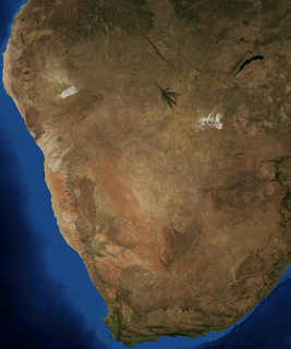
Botswana is a landlocked country located in Southern Africa, north of South Africa. Botswana occupies an area of 581,730 square kilometres (224,610 sq mi), of which 566,730 km2 (218,820 sq mi) are land. Botswana has land boundaries of combined length 4,347.15 kilometres (2,701.19 mi), of which the constituent boundaries are shared with Namibia, for 1,544 km (959 mi); South Africa 1,969 km (1,223 mi); Zimbabwe, 834 km (518 mi) and Zambia, 0.15 km (0.093 mi). Much of the population of Botswana is concentrated in the eastern part of the country.
The Kalahari Desert is a large semi-arid sandy savanna in Southern Africa extending for 900,000 square kilometres (350,000 sq mi), covering much of Botswana, and parts of Namibia and South Africa.

At 824,292 km2 (318,261 sq mi), Namibia is the world's thirty-fourth largest country. After Mongolia, Namibia is the second least densely populated country in the world.

Veld, also spelled veldt, is a type of wide open rural landscape in Southern Africa. Particularly, it is a flat area covered in grass or low scrub, especially in the countries of South Africa, Lesotho, Eswatini, Zimbabwe and Botswana. A certain sub-tropical woodland ecoregion of Southern Africa has been officially defined as the Bushveld by the World Wide Fund for Nature. Trees are not abundant—frost, fire and grazing animals allow grass to grow but prevent the build-up of dense foliage.

The Okavango River is a river in southwest Africa. It is the fourth-longest river system in southern Africa, running southeastward for 1,600 km (1,000 mi). It begins at an elevation of 1,300 metres (4,300 ft) in the sandy highlands of Angola, where it is known by the Portuguese name Rio Cubango. Farther south, it forms part of the border between Angola and Namibia, and then flows into Botswana. The Okavango does not have an outlet to the sea. Instead, it discharges into the Okavango Delta or Okavango Alluvial Fan, in an endorheic basin in the Kalahari Desert.

The Okavango Delta in Botswana is a swampy inland delta formed where the Okavango River reaches a tectonic trough at an altitude of 930–1,000 m in the central part of the endorheic basin of the Kalahari. All the water reaching the delta is ultimately evaporated and transpired and does not flow into any sea or ocean. Each year, about 11 cubic kilometres (2.6 cu mi) of water spreads over the 6,000–15,000 km2 (2,300–5,800 sq mi) area. Some flood waters drain into Lake Ngami. The area was once part of Lake Makgadikgadi, an ancient lake that had mostly dried up by the early Holocene.

The Makgadikgadi Pan, a salt pan situated in the middle of the dry savanna of north-eastern Botswana, is one of the largest salt flats in the world. The pan is all that remains of the formerly enormous Lake Makgadikgadi, which once covered an area larger than Switzerland, but dried up tens of thousands of years ago. Recent studies of human mitochondrial DNA suggest that modern Homo sapiens first began to evolve in this region some 200,000 years ago, when it was a vast, exceptionally fertile area of lakes, rivers, marshes, woodlands and grasslands especially favorable for habitation by evolving hominins and other mammals.

The Kalahari Basin, also known as the Kalahari Depression or the Okavango Basin, is an endorheic basin and large lowland area covering over 2.5 million km2 covering most of Botswana and Namibia, as well as parts of Angola, South Africa, Zambia, and Zimbabwe. The outstanding physical feature in the basin, and occupying the centre, is the large Kalahari Desert.

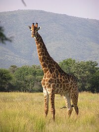
The wildlife of Botswana refers to the flora and fauna of this country. Botswana is around 90% covered in savanna, varying from shrub savanna in the southwest in the dry areas to tree savanna consisting of trees and grass in the wetter areas. Even under the hot conditions of the Kalahari Desert, many different species survive; in fact the country has more than 2500 species of plants and 650 species of trees. Vegetation and its wild fruits are also extremely important to rural populations living in the desert and are the principal source of food, fuel and medicine for many inhabitants.

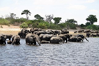
The Zambezian flooded grasslands is an ecoregion of southern and eastern Africa that is rich in wildlife.

Angolan mopane woodlands are situated in southwestern Angola, extending into northern Namibia. This ecosystem surrounds Etosha Pan, which is considered a separate ecoregion. The mopane trees are the main type of vegetation.
Kavango–Zambezi Transfrontier Conservation Area was a conservation proposal for a region of Southern Africa where the international borders of five countries converge. It was to include a major part of the Upper Zambezi River and Okavango basins and Delta, the Caprivi Strip of Namibia, the southeastern part of Angola, southwestern Zambia, the northern wildlands of Botswana and western Zimbabwe. The centre of this area is at the confluence of the Zambezi and Chobe Rivers where the borders of Botswana, Namibia, Zambia and Zimbabwe meet. It would have incorporated Chobe National Park, Hwange National Park, and the Victoria Falls.

The Nata Bird Sanctuary, the only protected reserve in Botswana in the northeastern periphery of Sowa Pan, is a community-managed project, with assistance from the Nata Conservation Committee and national and international organizations. Founded in 1988, it opened for operations in 1993; it encompasses an area of 230 square kilometres (89 sq mi), with the objective of conservation of wildlife. The community project is managed by a Trust titled the "Kalahari Conservation Society", which has members drawn from the four villages of Nata, Sepako, Maposa and Manxotae in the vicinity of the sanctuary.

Bwabwata National Park is a protected area in northeastern Namibia that was established in 2007 and covers 6,274 km2 (2,422 sq mi). It was created by merging Caprivi Game Park and Mahango Game Reserve. It is situated in the Zambezi and Kavango East regions, extending along the Caprivi Strip. It is bounded by the Okavango River to the west and the Kwando River to the east. Angola lies to the north and Botswana to the south.

The Zambezian and mopane woodlands is a tropical and subtropical grasslands, savannas, and shrublands ecoregion of southeastern Africa.
The Zambezian region is a large biogeographical region in Africa. The Zambezian region includes woodlands, savannas, grasslands, and thickets, extending from east to west in a broad belt across the continent. The Zambezian region lies south of the rainforests of the Guineo-Congolian region. The Zambezian region is bounded by deserts and xeric shrublands on the southwest, the Highveld grasslands of South Africa to the south, and the subtropical Maputaland forests on the southeast.

The Zambezian Baikiaea woodlands is an ecoregion in Africa. It includes dry deciduous forest and woodland, thicket, and grassland, dominated by the tree Baikiaea plurijuga. The ecoregion has a semi-arid climate, and is a transition between more humid miombo woodlands to the north, and the drier Kalahari Acacia-Baikiaea woodlands to the south.