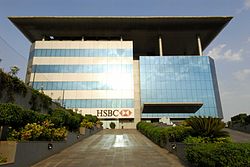
Pune, previously spelled in English as Poona, is a city in Maharashtra state in the Deccan plateau in Western India. It is the administrative headquarters of the Pune district, and of Pune division. According to the 2011 Census of India, Pune is the ninth-most populous city in India with a population of 3.1 million residents within the city limits, and has a population of 7.2 million residents in the metropolitan region, making it the eight-most populous metropolitan area in India. The city of Pune is part of Pune Metropolitan Region. Pune is one of the largest IT hubs in India. It is also one of the most important automobile and manufacturing hubs of India. Pune is a developing city. Pune is often referred to as "Oxford of the East" because of its highly regarded educational institutions. It has been ranked "the most liveable city in India" several times.

Khadakwasla Dam is a dam on the Mutha River 21 km (13 mi) from the centre of the city of Pune in Maharashtra, India. The dam created a reservoir known as Khadakwasla Lake which is the main source of water for Pune and its suburbs.

The Mutha River is a river in western Maharashtra, India. It arises in the Western Ghats and flows eastward until it merges with the Mula River in the city of Pune. It has been dammed twice, first at the Panshet Dam, used as a source of drinking water and irrigation for Pune city. The water released here is dammed again at Khadakwasla and is an important source of drinking water for Pune. One more dam has been built later on the Mutha river at Temghar.

Pimpri-Chinchwad also known as "PCMC", is a city in the Indian state of Maharashtra. The city is about 15 km (9.3 mi) northwest of the historic city of Pune, at an altitude of 590 m (1,940 ft) above sea level. It is the fifth largest city in Maharashtra and the nineteenth largest city in India and the sixteenth largest satellite city in the world by population. The city is located 135 km (84 mi) southeast from the state's capital Mumbai. It is one of the most rapidly developing suburban areas in India and has emerged as the third fastest growing city in the country. It is well known for its automotive, IT and manufacturing industry.

The Bhima River is a major river in Western India and South India. It flows southeast for 861 kilometres (535 mi) through Maharashtra, Karnataka, and Telangana states, before joining the Krishna River. After the first sixty-five kilometers in a narrow valley through rugged terrain, the banks open up and form a fertile agricultural area which is densely populated.

The Mula is a river in Pune, in Maharashtra state of India. It is dammed near the Western Ghats at the Mulshi Dam that forms the Mulshi Lake. Further downstream, in Pune city, it merges with the Pawana River on the left bank and Mutha River on the right bank to form the Mula-Mutha river, which later meets the Bhima River.

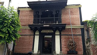
The Aga Khan Palace was built by Sultan Muhammed Shah Aga Khan III in the city of Pune, India.
Pammal is a neighborhood in the city of Tambaram, situated within the Chennai Metropolitan Area, Tamil Nadu, India.

Aundh is an upscale, affluent neighbourhood in the city of Pune, India. Since its inception in the mid-1990s, Aundh has developed significantly as a residential area with proximity to the University of Pune.
Chinchwad is an upscale locality in the city of Pimpri Chinchwad, which is about 15 km (9.3 mi) northwest of the historic city of Pune situated on the banks of Pavna river. The neighborhood is home to extensive industry and is well known for its automotive, pharmaceutical, electrical products, electronics and hardware, aerospace and manufacturing units.
Chakan is a census town in India, in Pune district of the Indian state of Maharashtra. While agriculture remains an important factor, the town's industrial development is quickly urbanizing the area. The Independent referred Chakan as India's "Motor City".
Viman Nagar is an affluent residential and retail neighborhood in the Eastern Metropolitan Corridor of Pune and is one of the regions in the city. Viman Nagar is in close proximity to the Pune International Airport and constitutes the eastern necklace of the city along with Koregaon Park and Kalyani Nagar.

Hinjawadi is a suburb in Pimpri Chinchwad on the outskirts of Pune, India. It houses the Rajiv Gandhi Infotech Park, a large tech and business park spread over 2,800 acres, which was built by the Maharashtra Industrial Development Corporation. The IT Park is home to over 800 IT companies of all sizes.

The Mula-Mutha is a river in India, formed by the confluence of the Mula and Mutha rivers in the city of Pune, Maharashtra state, which later flows into the Bhima River, which itself is a tributary of the Krishna River and finally empties into the Bay of Bengal.

Pune Metro is a mass rapid transit system serving the city of Pune, India. The system comprises 3 lines with a combined length of 54.14 km (33.64 mi), of which 21.75 km (13.51 mi) on two lines are operational as of August 2023. The 16.59 km (10.31 mi) Purple Line from PCMC Bhavan to Swargate runs on an elevated viaduct between PCMC Bhavan to Range Hills, from where it goes underground. The Aqua Line runs from Vanaz to Ramwadi covering a distance of 14.66 km (9.11 mi) on an elevated viaduct. The 23.33 km (14.50 mi) elevated Line 3 will run from the Rajiv Gandhi Infotech Park in Hinjawadi via Balewadi to Civil Court. All three lines will align at the Civil Court interchange station.

Yerawada is a neighbourhood of the city of Pune in the state of Maharashtra, India. Before that British Raj Yerawada was known as Yeraoda. Yerawada is one of the most densely populated areas in Pune. It is located at the beginning of Ahmednagar highway and also on the way to old Pune Airport at Lohagaon. This place can be reached after crossing Mula-Mutha River through Yerawada Bridge from Bund Garden.
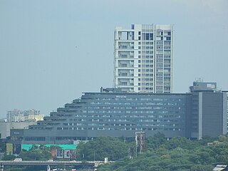
Koregaon Park is an area located in Pune, in the state of Maharashtra in India. It is primarily a residential area with lush greenery, but of late has been growing into a commercial hub as well. Koregaon Park also has a trendy dining and nightlife hub, with sleek European and Indian restaurants, plus live music bars and buzzy pubs. It is also a destination for art and music enthusiasts in the city with many art galleries and clubs in the vicinity. Koregaon Park is located about 5.8 kilometres (3.6 mi) from the Pune International Airport and about 3.8 kilometres (2.4 mi) from the Pune Junction railway station.
Vishrantwadi is a suburb of Pune City in the State of Maharashtra, India. Vishrantwadi is a bustling commercial and residential neighborhood to the north of the city and includes the areas of Mohanwadi, Pratik Nagar, Kasturbawadi, Phule Nagar, Mental Corner, Police Lines, Shanti Nagar, Dhanori, Tingre Nagar, Kalas, Mhaskewasti and Dighi.

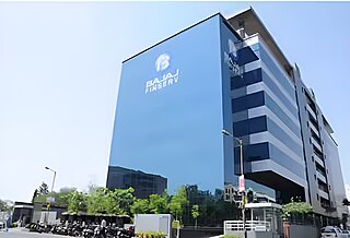
Kharadi is a suburb located in the Eastern Metropolitan Corridor of Pune, India, on the banks of the Mula-Mutha river that serves as a hub for information technology and business parks. Initially, it was referred to as a village however, during recent times with reference to the introduction of the information technology businesses in Kharadi, the suburb has evolved into a major metropolitan corridor for techies in Pune.
Wadgaon Sheri is an upmarket residential and commercial neighborhood of Pune, India located off the Nagar Road. Earlier a village outside the city, It is now one of the upmarket areas of Pune, with real estate prices being quite high. It is an upscale residential location due to easy accessibility to work and leisure as well as good educational institutions, making it a coveted and highly sought after residential destination. A significant central section of Wadgaon Sheri, Digambar Nagar, has been renamed New Kalyani Nagar given the massive new upscale constructions from several prominent real estate organizations in the city and also its strategic location in close proximity to posh area of Kalyani Nagar. The entire locality is bounded by Nagar Road towards north and Mula Mutha River towards south. Also, the upscale area of Koregaon Park and IT hub of Kharadi are easily accessible, nearly 5 km, from Wadgaon Sheri. Several apartment complexes, completed as well as developing, are spread across the locality.