
Kennebunk is a town in York County, Maine, United States. The population was 11,536 at the 2020 census. Kennebunk is home to several beaches, the Rachel Carson National Wildlife Refuge, the 1799 Kennebunk Inn, many historic shipbuilders' homes, the Brick Store Museum and the Nature Conservancy Kennebunk Plains, with 1,500 acres (6 km2) of nature trails and blueberry fields.

The Mousam River is a 29.7-mile-long (47.8 km) river in York County, Maine, United States. Its primary source is Mousam Lake, located between the towns of Shapleigh and Acton, and it flows into the Atlantic Ocean just west of Kennebunk Beach. It flows through the towns of Shapleigh, Sanford and Kennebunk.

The Middle Haddam Historic District is a historic district in the town of East Hampton, Connecticut. It encompasses the village center of Middle Haddam, a riverfront community founded in the 17th century on the east bank of the Connecticut River. It was an important port on the river between about 1730 and 1880. Its layout and architecture are reflective of this history, and by the geographic constraints of the local terrain. The district was listed on the National Register of Historic Places in 1984.

The Coram Shipyard Historic District is a historic district encompassing a colonial-era shipyard at 2120, 2125, and 2130 Water Street in Dighton, Massachusetts. The district includes two houses, built c. 1700, and the archaeologically sensitive site of a shipyard which operated for a roughly five-year period between 1698 and 1703. The shipyard site is now home to the Taunton River Yacht Club, whose property includes the wharf built by Thomas Coram and John Hathaway, the proprietors of the shipyard. The district was listed on the National Register of Historic Places in 1998.

The York Historic District encompasses the historic village center of York, Maine, one of the oldest communities in the state. The expansive 1,700-acre (690 ha) district includes the oldest church in Maine, built by its oldest congregation in 1747, and the Old York Gaol, a National Historic Landmark that is one of the oldest public buildings in the United States. The district was listed on the National Register of Historic Places in 1973.
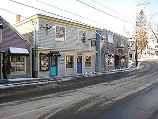
The Kennebunkport Historic District encompasses most of the village center of Kennebunkport, Maine. It includes the town's highest concentration of historic architecture, with many buildings from the late 18th and early 19th century, when Kennebunkport was at its height as a shipping and shipbuilding center. The district was added to the National Register of Historic Places on May 6, 1976.
The Five Mile River Landing Historic District encompasses a predominantly 19th-century residential area in the Rowayton section of Norwalk, Connecticut. It extends along Rowayton Street from Witch Lane to Pennoyer Street, and includes all of the properties on the latter as well. The area was a major local center of the shipping industry in the 19th century. The historic district was listed on the National Register of Historic Places in 2009.
Stroudwater Historic District is a historic district in the Stroudwater neighborhood of Portland, Maine. The district encompasses an important early village in the Portland area, significant as a shipbuilding and mill site established by Thomas Westbrook in 1727. The district was added to the National Register of Historic Places in 1973.
The Harraseeket Historic District encompasses some of the oldest maritime village areas of the town of Freeport, Maine. It includes properties along both banks of the tidal Harraseeket River, from the Mast Landing area in the north to Wolf Neck and the villages of Porter Landing and South Freeport on the west bank of the river. The district was listed on the National Register of Historic Places in 1974.
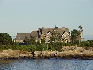
The Cape Arundel Summer Colony Historic District encompasses an enclave of large summer estates on the coast of Kennebunkport, Maine. The area was developed in the late 19th and early 20th century as a resort area for the wealthy of the northeastern United States. It notably includes the Kennebunk River Club and Walkers Point, the location of the Bush compound, which has a Shingle-style house built in 1903. The district was listed on the National Register of Historic Places in 1984.

The Old Kennebunk High School, also known as the Park Street School, is an historic former school building at 14 Park Street in Kennebunk, Maine. Built in 1922–23 to a design by Hutchins & French of Boston, Massachusetts, it is historically significant for its role the city's education, and architecturally as a fine example of a "modern" high school building of the period with Colonial Revival styling. It was listed on the National Register of Historic Places in 2011.
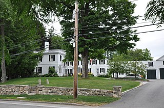
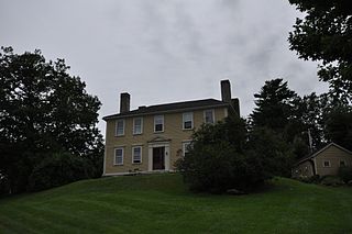
The Lord Mansion is a historic house at 20 Summer Street in Kennebunk, Maine. The multi-part house includes a 1760 Georgian house as an ell to its main element, an 1801 Federal period structure. The house was listed on the National Register of Historic Places in 1973 for its architectural significance; it is also a contributing element to the Kennebunk Historic District.

The Lower Alewive Historic District encompasses a rural agricultural landscape in northwestern Kennebunk, Maine. It includes four farm properties, all originally laid out in the 1750s, between the Kennebunk River to the north, and a street now variously named Russell Farm Road, Emmons Road Extension, and Winnow Hill Lane to the south. The district was listed on the National Register of Historic Places in 1994.

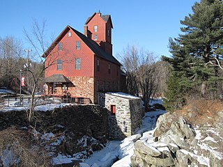
The Sanford Mills Historic District encompasses a large industrial complex in the center of Sanford, Maine, United States. From 1867 to 1955, the property was the site of a major textile manufacturing operation that was a major local employer. The site, flanking the Mousam River just north of Sanford's central business district, was listed on the National Register of Historic Places in 2009.
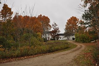
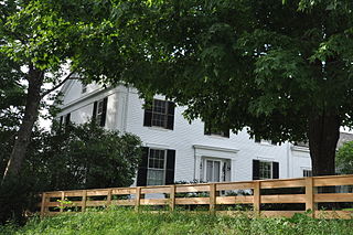
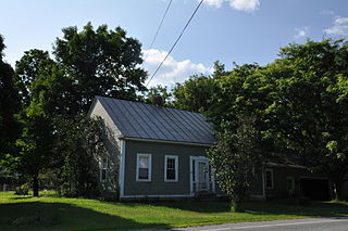
The James Smith Homestead is a historic house on 5 Russell Farm Road in Kennebunk, Maine. Built in 1753, it is one of the few surviving mid-18th century inland farmhouses in the town. It was listed on the National Register of Historic Places in 1982, and is included in the Lower Alewive Historic District.

The Searsport Historic District encompasses a collection of well-preserved mid-to-late 19th-century commercial buildings in the center of Searsport, Maine. They represent the community's peak period of prosperity, when it was a leading shipping and shipbuilding center. The district was listed on the National Register of Historic Places in 1979.
The South Street Historic District encompasses an early residential area of Gorham, Maine. Located just south of Gorham's small commercial center, South Street is lined with an architecturally cohesive collection of about 20 late-18th and early-19th century houses, primarily interrupted only by the presence of the modest Colonial Revival Baxter Memorial Library. The district was listed on the National Register of Historic Places in 1988.
The Christian Street Rural Historic District encompasses the surviving elements of an early settlement village in the town of Hartford, Vermont. Centered on the junction of Christian Street and Jericho Street in northeastern Hartford, the area includes a modest number of 18th and 19th-century houses, as well as two farms that have been in the same families since the 18th century. The district was listed on the National Register of Historic Places in 2003.

The Weston Village Historic District encompasses the town center and principal village of Weston, Vermont. Centered on Farrar Park, which serves as the town green, it includes a diversity of architectural styles from the late 18th century to about 1935, and includes residential, civic, commercial, industrial and religious buildings. It was listed on the National Register of Historic Places in 1985.
The Jericho Village Historic District encompasses the historic industrial and commercial center of the village of Jericho, Vermont. Stretched along Vermont Route 15 south of Browns River, which powered the village's industries for many years, the village center includes a well-preserved array of 19th and early 20th-century buildings. The district was listed on the National Register of Historic Places in 1992.


