Kingston Bridge, Glasgow

Last updated

Kingston Bridge
Wfm kingston bridge.jpg
Kingston Bridge, looking eastward up the River Clyde.
Coordinates 55°51′19″N4°16′12″W / 55.85528°N 4.27000°W / 55.85528; -4.27000
CarriesMotor vehicles only (motorway bridge)
Crosses River Clyde
Locale Glasgow, Scotland
Official nameKingston Bridge
Characteristics
DesignBalanced cantilever with triple-cell segmented prestressed concrete box girders
Designer: William Fairhurst
Contractor: Logan-Marples Ridgway
Width Dual five-lane carriageway each carriageway: 21 metres (69 ft)
Longest span143 m (470 ft) (side spans 62.5 m)
History
Opened26 June 1970 (53 years ago)
Statistics
Daily traffic 150,000 vehicles
TollFree
Location
Kingston Bridge, Glasgow

The Kingston Bridge is a balanced cantilever dual-span ten lane road bridge made of triple-cell segmented prestressed concrete box girders crossing the River Clyde in Glasgow, Scotland.

Contents

Carrying the M8 motorway through the city centre, the Kingston Bridge is one of the busiest bridges in Europe, carrying around 150,000 vehicles every day. [1] [2] [3]

History

The name of the bridge refers to the Kingston area on the south of the river. The erstwhile Kingston Dock which was located on the south bank of the river was closed to allow for construction of the bridge. It had been completed in 1867 between Windmillcroft Quay and the former headquarters of the Scottish Co-operative Wholesale Society on Morrison Street, adjacent to where the bridge now stands. It was Glasgow's first enclosed dock. The dock was eventually closed to navigation in 1966, when work began on the construction of the Kingston Bridge; the basin was subsequently filled in and housing built on the site. [4] At the time of construction, however, the Clyde Port Authority still insisted that the bridge have a clearance height of 18 m (60 ft) in order to allow dredgers to go upstream as far as the King George V Bridge.

Kingston Bridge was first proposed in 1945 as part of the Glasgow Inner Ring Road scheme. After feasibility studies were carried out, William Fairhurst was appointed consulting engineer for the design of the bridge and its approaches and on 15 May 1967 construction began. Construction was a joint venture between Duncan Logan (Construction) Ltd. [5] and Marples Ridgway. The eventual cost was £2.4m excluding the approach viaducts (or around £11m in total). On 26 June 1970 Kingston Bridge was opened by Queen Elizabeth the Queen Mother. [6]

Location

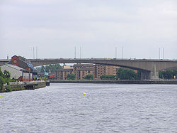
The bridge connects Anderston and the city centre at Junction 18/19 with Kingston, Tradeston and the Gorbals at Junction 20. It consists of two parallel spans, each 21 m (68 ft) wide, with each supporting a five lane deck. The eastern span carries southbound traffic and the western span carries northbound traffic over the river. The approaches to the bridge are also linked with many junctions of their own, including major city centre ramps and the M77, that are two lanes wide. The outer spandrels of the bridge are clad with exposed-aggregate panels showing vertical joints.

Refurbishment

When opened by Queen Elizabeth the Queen Mother in 1970, the bridge was designed to handle 120,000 vehicles a day. [7] By 1990, the sheer excess volume and weight of traffic, combined with poor design and flaws in construction, resulted in serious structural deterioration. [8] A decade-long repair and renovation programme was initiated to repair and strengthen the bridge. [1] These repairs have involved strengthening the quay walls and jacking-up the 52,000-tonne deck of the bridge, while still operational, to allow the construction of new supporting piers, before lowering the bridge back onto the new, more robust supports. It was described by the contractor, Balfour Beatty, as one of the most ambitious civil engineering projects to take place in the city. Indeed, the operation involved 128 hydraulic jacks, making it the biggest ever bridge lift, qualifying for the Guinness Book of Records . [9]

A longer-term attempt to solve the problem of chronic congestion is the M74 northern extension, to act as the southern flank of the unbuilt Glasgow Inner Ring Road first planned in the 1960s. The existing "ski ramp" where the Inner Ring was intended to continue on has remained unused; the extended M74 meets the M8 secondary carriageways a few hundred metres further south at Scotland Street. This change of plan from the Scottish Executive was because of the Kingston Bridge's inability to handle an increase in traffic: the thinking was that the increased traffic from the new road would not then go straight over the bridge and would enable traffic from the south east, heading west to Ayrshire, Glasgow International Airport, Glasgow Prestwick Airport, or the docks at Greenock, Hunterston and Braehead, to bypass the Glasgow city centre section of the M8.[ citation needed ] At the Public Inquiry into the road scheme, critics countered that this would mean an increase in ground-level traffic in the Tradeston area as commuters attempted to gain access to the bridge's access ramps. [10] Prior to the M74 completion, a solution to the congestion problems was the Clyde Arc or "Squinty Bridge", which opened in September 2006 – this route was expected to take at least some of the local short-distance traffic away from the Kingston. The M74 extension opened on 28 June 2011.

There is a dubious urban myth that the fourth man in the Williamwood bank robbery, Archie McGeachy, is buried in the pillars of the bridge. [11] It features in the music video for the Simple Minds single "Speed Your Love to Me". [12]

The bridge's 50th anniversary took place in 2020; [13] at the end of that year it was listed at Category C by Historic Environment Scotland as a "significant – albeit controversial – infrastructure project which transformed the city of Glasgow... also has special architectural interest". [14]

Related Research Articles

<span class="mw-page-title-main">A8 road (Scotland)</span> Road in Scotland

The A8 is a major road in Scotland, connecting Edinburgh to Greenock via Glasgow. Its importance diminished following the construction of the M8 motorway which also covers the route between Edinburgh and Glasgow.

<span class="mw-page-title-main">M8 motorway (Scotland)</span> Busiest motorway in Scotland

The M8 is the busiest motorway in Scotland. It connects the country's two largest cities, Glasgow and Edinburgh, and serves other large communities including Airdrie, Coatbridge, Greenock, Livingston and Paisley. The motorway is 60 miles (97 km) long. A major construction project to build the final section between Newhouse and Baillieston was completed on 30 April 2017. The motorway has one service station, Heart of Scotland Services, previously named Harthill due to its proximity to the village.

<span class="mw-page-title-main">A74(M) and M74 motorways</span> Major motorway in Scotland

The A74(M) and M74 form a major motorway in Scotland, connecting it to England. The routes connect the M8 motorway in central Glasgow to the Scottish-English border at Gretna. In conjunction with their southward continuation, the M6 motorway, they form one of the three major cross-border routes between Scotland and England. They are part of the unsigned international E-road network E05. Although the entire route is colloquially referred to as the M74, for more than half its length, south of Abington, the road is officially the A74(M); see naming confusion below.

<span class="mw-page-title-main">M73 motorway</span> Motorway in Scotland

The M73 is a motorway in Glasgow and North Lanarkshire, Scotland. It is 7 miles (11 km) long and connects the M74 motorway with the M80 motorway, providing an eastern bypass for Glasgow. The short stretch between junctions 1 and 2 is part of unsigned international E-road network E05, where it continues along the M8 through Glasgow. To the south, the M74 motorway is also part of the E05.

<span class="mw-page-title-main">M77 motorway</span> Motorway in Scotland

The M77 motorway is a motorway in Scotland. It begins in Glasgow at the M8 motorway at Kinning Park, and terminates near Kilmarnock at Fenwick, becoming the A77 dual carriageway. Changes were made in 2005 segregating a lane on the M8 motorway almost as far as the Kingston Bridge, which in January 2006 was extended further onto the bridge itself. It forms the most northerly part of the A77 trunk road which links Glasgow to Stranraer in the South West of Scotland.

<span class="mw-page-title-main">A74 road</span> Road in Scotland

The A74 also known historically as the Glasgow to Carlisle Road, is a formerly major road in the United Kingdom, linking Glasgow in Scotland to Carlisle in the North West of England, passing through Clydesdale, Annandale and the Southern Uplands, and forms part of the wider arterial route between Glasgow and London. A road in this area has existed since Roman Britain, and it was considered one of the most important roads in Scotland, being used as a regular mail service route.

<span class="mw-page-title-main">Transport in Glasgow</span> Overview of transport in Glasgow

The city of Glasgow, Scotland, has a transport system encompassing air, rail, road and an underground light metro line. Prior to 1962, the city was also served by trams. Commuters travelling into Glasgow from the neighbouring local authorities of North and South Lanarkshire, Renfrewshire, East Renfrewshire, and East and West Dunbartonshire have a major influence on travel patterns, with tens of thousands of residents commuting into the city each day. The most popular mode of transport in the city is the car, used by two-thirds of people for journeys around the city.

<span class="mw-page-title-main">Tradeston</span> District of Glasgow, Scotland

Tradeston is a small district in the Scottish city of Glasgow adjacent to the city centre on the south bank of the River Clyde. The name reflected its role as a primarly dockland area with a large number of warehouses and wharves along the riverside were vessels would be unloaded. It merges to the south and west with Kingston, and the two districts are often considered one and the same.

<span class="mw-page-title-main">A728 road</span> Road in Scotland

The A728 is a route number in Glasgow, Scotland applied to two connected roads.

<span class="mw-page-title-main">Glasgow Inner Ring Road</span> Proposed road in Glasgow, Scotland, UK

The Glasgow Inner Ring Road is a partially completed ring road encircling the city centre of Glasgow, Scotland. Construction of the roads began in 1965, and half of its circumference was completed by 1972 - forming part of the wider M8 motorway, but no further construction was made and the remaining plans were formally abandoned in 1980.

<span class="mw-page-title-main">Clyde Arc</span> Bridge in Glasgow, Scotland

The Clyde Arc is a road bridge spanning the River Clyde in Glasgow, Scotland, connecting Finnieston near the Clyde Auditorium and SEC with Pacific Quay and Glasgow Science Centre in Govan. Prominent features of the bridge are its innovative curved design, and that it crosses the river at an angle. The Arc is the first city centre traffic crossing over the river built since the Kingston Bridge was opened to traffic in 1970.

<span class="mw-page-title-main">International Financial Services District</span> Multiple buildings containing office space in Glasgow, Scotland

The International Financial Services District (IFSD) began being marketed and developed in succession to the Broomielaw Project pioneered by the Scottish Development Agency in the late 1980s. A public-private financial district in Glasgow, Scotland; attracting inward investment for leading international financial services companies and a re-location option for existing Glasgow-based companies, seeking to expand their operations.

<span class="mw-page-title-main">A725 road</span> Road in Scotland

The A725 road in Scotland is a major route which is a trunk road dual carriageway for almost its whole length, connecting several of the large towns of North Lanarkshire and South Lanarkshire, linking the M8 and M74 motorways; it has been upgraded frequently since its construction, with the most recent major work completed in 2017. In combination with the A726 road which meets the M77 motorway, it forms a southern and eastern bypass for the city of Glasgow.

<span class="mw-page-title-main">A726 road</span> Road in Scotland

The A726 road in Scotland is a major route with several distinct sections with different characteristics and names; owing to its stages of construction, since 2005 it has two separate parts, the first running between Strathaven in South Lanarkshire and Junction 5 of the M77 motorway south of Newton Mearns in East Renfrewshire via East Kilbride, and the other running between Junction 3 of the M77 and the M898 motorway near the Erskine Bridge, via Paisley and Junction 29 of the M8 motorway near Glasgow International Airport.

<span class="mw-page-title-main">A814 road</span> Road in Scotland

The A814 road in Scotland is a major arterial route within Glasgow, connecting the city centre to the west end. Running along the right (north) bank of the River Clyde, it continues further west through Clydebank and Dumbarton, leaving the suburban environment and serving as the main road for Helensburgh, turning north to meet the A83 at Arrochar, Argyll and Bute.

<span class="mw-page-title-main">Argyle Street, Glasgow</span> Thoroughfare in Glasgow

Argyle Street is a major thoroughfare in the city centre of Glasgow, Scotland.

St Andrew's Cross, also known as Eglinton Toll, is a road junction in the south side of the city of Glasgow, Scotland. First constructed during the early 1800s, the junction formerly held several buildings including a power station and cinema, but have been removed for a variety of reasons. Since 1946 when the junction underwent a realignment, the two roads no longer intersect.

<span class="mw-page-title-main">Plantation, Glasgow</span> Human settlement in Scotland

Plantation is an area in the city of Glasgow, Scotland. It is situated south of the River Clyde and is part of the former Burgh of Govan. It lies approxmately between the areas of Cessnock and Ibrox to the west, Kingston to the east, and Kinning Park to the south.

<span class="mw-page-title-main">Auchenshuggle Bridge</span>

Auchenshuggle Bridge is a road bridge spanning the River Clyde in Glasgow, Scotland. The Auchenshuggle Bridge is the latest bridge to be built over the Clyde in the Auchenshuggle district of Glasgow, carrying the M74 motorway over the river and onto land which is part of Clydebridge Steelworks in Rutherglen, en route to the M8 junction near the heavily congested Kingston Bridge.

<span class="mw-page-title-main">Kingston, Glasgow</span>

Kingston is an area of Glasgow, Scotland, from which the Kingston Bridge takes its name. Together with Ibrox, it forms one of the 56 neighbourhoods of Glasgow defined by Glasgow City Council for operational purposes. The area was assigned to Ward 54 until 2007 when it was reclassified as part of the Govan ward.

References

  1. 1 2 "BBC News | Scotland | Bridge traffic flows again". news.bbc.co.uk. 30 October 1999.
  2. "Scottish Government Tolled Bridges Review 2004".
  3. "Traffic statistics (1975-2015)". Glasgow motorway archive.
  4. Graham, Scott. "TheGlasgowStory: Kingston Dock". www.theglasgowstory.com. Retrieved 24 January 2018.
  5. Glasgow Official Handbook and Industrial Review : Corporation of Glasgow/Adcon Ltd : 1968 : page 14
  6. "Engineering Timelines - Kingston Bridge, Glasgow". www.engineering-timelines.com. Retrieved 24 January 2018.
  7. "Glasgow 1980 (1971)". Vimeo.
  8. Report in Concrete magazine, Nov/Dec 2001
  9. "亚搏彩票:团亚搏彩票委". www.sunnygovan.com.
  10. "Report on objections made during public enquiry".
  11. "CONCRETE TOMB; Repairs may unearth bodies of gangsters. - Free Online Library". www.thefreelibrary.com. Retrieved 24 January 2018.
  12. Glasgow Motorway Archive - Kingston Bridge and Approaches
  13. 50 years of the Kingston Bridge, Transport Scotland, 25 June 2020
  14. Kingston Bridge awarded Category C listing status, Historic Environment Scotland, 12 November 2020
Next crossing upstream River Clyde Next crossing downstream
Tradeston Bridge Kingston Bridge Clyde Arc