Kirandul

Last updated • 7 min readFrom Wikipedia, The Free Encyclopedia

Kirandul
town
Bailadila Hill.jpg
Bailadila hills
India Chhattisgarh location map.svg
Red pog.svg
Kirandul
India location map.svg
Red pog.svg
Kirandul
Coordinates: 18°37′57″N81°15′34″E / 18.63250°N 81.25944°E / 18.63250; 81.25944
CountryFlag of India.svg  India
State Chhattisgarh
District Dantewada
Government
  TypeMunicipality
  Body Nagar Palika Kirandul
Elevation
540 m (1,770 ft)
Population
 (2011)
  Total18,887
Languages
  Official Hindi, Halbi
  Other Gondi, Telugu, Koya
Time zone UTC+5:30 (IST)
PIN
494556 [1]
Telephone code07857
Vehicle registration CG-18
Nearest city Jagdalpur, Dantewada
Sex ratio 932 / 1000
Lok Sabha constituency Bastar
Vidhan Sabha constituency Dantewada
Website dantewada.gov.in

Kirandul is a town and a municipality in Dantewada district [2] in the Indian state of Chhattisgarh. It is located roughly 400 km south of Raipur, capital of Chhattisgarh and 41 km southwest of Dantewada-the district headquarters. The way to travel is by road with frequent bus service from Raipur, Bhilai and Jagdalpur or by train from Jagdalpur and Visakhapatnam.It has the world's largest iron ore mine according to 2021 survey

Contents

Demographics

As of 2011 India census, [3] Kirandul had a population of 18887 of which 9776 are males while 9111 are females as per report released by Census India 2011.

Population of children with age of 0-6 is 2317 which is 12.27% of total population of Kirandul M). In Kirandul Municipality, Female Sex Ratio is of 932 against state average of 991. Moreover child sex ratio in Kirandul is around 1015 compared to Chhattisgarh state average of 969. Literacy rate of Kirandul town is 73.7% - higher than state average of 71.04%. In Kirandul, male literacy is around 79.9% while female literacy rate is 67.02%.

Region

This region is basically a plateau. [4] The Bailadila Range of hills are located at a distance of about 41 km south west of Dantewada, the district headquarters in Chhattisgarh State.

Rising to a height of 1,276 m, one of the hills of the Bailadila Range is the highest point in the state of Chhattisgarh. [5] Bailadila has been established as an industrial area that has been divided into two towns, namely Bade Bacheli (29 kilometers from Dantewada) & Kirandul (41 kilometers from Dantewada). [6]

Climate

Hilltop view from Football ground during rainy season Football ground, Kirandul.jpg
Hilltop view from Football ground during rainy season

Bailadila region enjoys mild summer and winter is not severe. The maximum temperature in summer rises up to 40 degree Celsius between May and June whereas minimum temperature in winter drops to 10 degree Celsius. The area receives heavy rains during monsoon from June to October. Weather during rainy season is stormy accompanied by gales and the hilltops are covered with thick clouds and dense fog, which reduces visibility.

Climate data for kirandul, India
MonthJanFebMarAprMayJunJulAugSepOctNovDecYear
Record high °C (°F)32.9
(91.2)
35.9
(96.6)
39.6
(103.3)
42.5
(108.5)
44.8
(112.6)
42.6
(108.7)
35.9
(96.6)
33.4
(92.1)
34.0
(93.2)
33.9
(93.0)
33.0
(91.4)
31.5
(88.7)
44.8
(112.6)
Mean daily maximum °C (°F)28.2
(82.8)
30.9
(87.6)
34.9
(94.8)
37.2
(99.0)
38.1
(100.6)
33.4
(92.1)
28.6
(83.5)
28.4
(83.1)
29.6
(85.3)
29.9
(85.8)
28.2
(82.8)
27.2
(81.0)
31.2
(88.2)
Daily mean °C (°F)19.9
(67.8)
23.0
(73.4)
26.9
(80.4)
30.0
(86.0)
31.2
(88.2)
28.5
(83.3)
25.7
(78.3)
25.4
(77.7)
25.9
(78.6)
24.7
(76.5)
21.7
(71.1)
19.5
(67.1)
25.2
(77.4)
Mean daily minimum °C (°F)11.6
(52.9)
14.3
(57.7)
18.5
(65.3)
22.2
(72.0)
24.2
(75.6)
23.8
(74.8)
22.3
(72.1)
22.2
(72.0)
22
(72)
19.6
(67.3)
14.9
(58.8)
11.1
(52.0)
18.9
(66.0)
Record low °C (°F)2.8
(37.0)
7.0
(44.6)
8.3
(46.9)
14.8
(58.6)
17.0
(62.6)
14.3
(57.7)
18.3
(64.9)
19.3
(66.7)
17.4
(63.3)
11.0
(51.8)
5.9
(42.6)
4.4
(39.9)
2.8
(37.0)
Average precipitation mm (inches)9.1
(0.36)
15.6
(0.61)
16
(0.6)
51.1
(2.01)
73.2
(2.88)
239.6
(9.43)
369.4
(14.54)
377.5
(14.86)
236.9
(9.33)
101.1
(3.98)
24.3
(0.96)
7.7
(0.30)
1,521.5
(59.90)
Average rainy days0.81.51.64.56.813.820.521.115.46.82.20.695.6
Average relative humidity (%)59514243476984868274686564
Source: Weatherbase [7]

History

The commercial discovery of Bailadila dates back to 1955-56 when Prof. Euemura of Japanese Steel Mills Association, [8] studying the memoirs of Geological Survey of India, drew the attention of the Japanese Steel Mills to the richness of the vast deposits of iron ore and its proximity to the Eastern Coast of India. Later an agreement had been signed with the Japanese Steel Mills in 1960. [9] An approval of the project report prepared by NMDC was given in 1964 and the Mine Plant had been inaugurated in November 1968. Later on, National Mineral Development Corporation, with help of Japan set up the first iron ore plant in Kirandul. Currently Kobe Steel, Ltd. (株式会社神戸製鋼所, Kabushiki-gaisha Kōbe Seikō-sho) Japan is the biggest purchaser of its ore, but earlier it has also sold ore in Bhilai Steel Plant too.

Kirandul was a crucial part of the princely state of Bastar before India attained independence. Bastar region prospered under the reign of King Annama Deva, the brother of Kakatiya king Pratapa Rudra Deva of Warangal (Telangana). During the 19th century, the region came under the administration of the British rule. Eventually, it was acceded to the Indian Union on January 1, 1948, and the town became a part of the Bastar district of Madhya Pradesh and later in 2000, it was included in the newly formed Chhattisgarh state. [10]

Economy

Kirandul main road Kirandul main road.jpg
Kirandul main road

The iron ore mines here are also an important tourist attraction. Run by the Navratna Government Organization,'NMDC', [11] these mines operate with the latest technology and hi-tech machinery. However, one needs to obtain permit to visit the mines, which can be done by requesting the NMDC office. The mines are generally open to the public on Vishwakarma Puja day every year and huge number of people visit during that time. [12]

The Bailadila iron ore range extends for a length of 40 km with a width of about 10 km mostly along the top of hill, which constitute one of the richest concentration of iron-ore of world. The range contains 1200 million tonnes of high grade iron ore distributed in 14 deposits. [13] 14 reserves have been discovered, of which 3 are being mined. Deposit 14/11C and 11B are the mines located in Kirandul complex while Deposit 5, 10 and 11A are located in Bacheli complex of Bailadila Iron ore mines. [14] Bailadila Deposit-14 mine is the first large scale open cast mechanised iron ore mine in India for which DPR was prepared by NMDC and was commissioned in April, 1968.Bailadila Deposit-11C was commissioned in June, 1988. The ore is exported through Visakhapatnam Port. [15]

The entire area was brought to the mainstream of civilisation by the spectacular effort of NMDC by opening-up of mines. Today, Bailadila is a name to reckon within the world iron ore market because of its super high-grade iron ore. [16] Bailadila complex [17] possesses the world’s best grade of hard lumpy ore having +66% iron content, free from sulphur and other deleterious material and the best physical properties needed for steel making. [18] Essar Steel Slurry beneficiation plant is situated in Kirandul which is used to transport iron ore through Slurry pipeline to Essar Steel pellet plant facility in Visakhapatnam. It has its own helipad for personal usage. At 267 km, the Kirandul-Vizag pipeline is the longest Slurry pipeline in India. [19]

Essar slurry beneficiation plant, Kirandul Essar slurry benefication plant kirandul.jpg
Essar slurry beneficiation plant, Kirandul

Transport

Kirandul is easily accessible and well connected to Raipur, Visakhapatnam and Hyderabad by all-weather roads. It can also be reached by rail from Visakhapatnam. There is regular iron ore movement from this sector to Visakhapatnam port by rail. [20]

Rail Transport

Kirandul Railway Station Kirandul Railway Station.jpg
Kirandul Railway Station

The Kothavalasa–Kirandul line [21] of East Coast Railway from Kirandul to Visakhapatnam via Koraput is laid through the Eastern Ghats. Up to Araku station, it has many tunnels. [22] Also it pass through the highest elevation Broad gauge station in the Eastern ghats, Semiliguda, just before the Borra caves. Kirandul - Kottavalasa Railroad [23] is the record high Broad Gauge line in the Eastern Ghats. The KK Line has the distinction of being the second highest broad gauge railway line in the country after the one in Jammu. [24]

A line from Bailadila to Visakhapatnam via Jagdalpur is in place mainly for the purposes of evacuation of iron ore by National Mineral Development Corporation (NMDC) from Kirandul with limited passenger trains. Plans are underway for doubling the railway line from Bailadila to Jagdalpur. As of November 2023, the work has already started for doubling the railway line from Kirandul. Indian Railways has undertaken expansion work. [25] The cost of this is projected to be about INR 870 crore which is proposed to be initially borne by NMDC and NMDC will in turn get a rebate in the freight from Indian Railways towards the initial cost incurred by NMDC. [26]

Air transport

There is an airport at Jagdalpur where until recent years no scheduled services were run to or from here. This changed with the inauguration of flight services by Chhattisgarh CM Bhupesh Baghel in 2020 thereby giving Jagdalpur the privilege of having the second civil airport in the State. Although several attempts were made earlier in 2018 for flights to Bhubhaneshwar and Raipur, the project was not successful and was discontinued. Maa Danteshwari Airport in Jagdalpur has flights operated by Alliance Air to Raipur and Hyderabad where the travel time is 45 minutes and 75 minutes respectively. This is in contrast to the travel time by roadways of 7 hours and 12 hours respectively to the destinations thereby saving a considerable amount of time [27]

The airport was predominantly used by political leaders and insurgency operation-related activities by the army and the police. With the recent developments, the airport will serve the population of the nearby districts well and would act as a means of promoting tourism in the State. The airport also helped in boosting the vaccination programme against Covid-19 as the various medical equipment and medicines were conveniently transported. [28] The other nearest airports are Raipur Airport in the capital city of Raipur and Visakhapatnam Airport, Andhra Pradesh. [29]

Helicopter Services at Maa Danteshwari Heliport Helicopter Service at Maa Danteshwari Heliport.png
Helicopter Services at Maa Danteshwari Heliport

Further, a new Heliport with the name Maa Danteshwari Heliport, in the design of Swastik, is planned for construction at Bainpal of Kirandul area of Chhattisgarh State, and will be opened for operations in early 2024. Spread across 25 Acres, is being built by Om Sai Airports Private Limited at a Cost of 200 Crores INR, [30] is located 10 Kms from Bacheli, 40 Kms from the District - Dantewada, and 120 Kms from nearest Airport - Maa Danteshwari Airport, Jagdalpur, Chhattisgarh. The heliport will be primarily used for tourism and commercial purposes and is also utilized by District Administration for emergency purposes. Employees of NMDC and Indian Railways would be the major customers utilizing the services. The Heliport will be opened using 1 Helipad presently and will have 8 Helipads in total post completion of construction, A lounge, Fuel Farm and a Fire station and can accommodate both Single and Twin Engine Helicopters. Routes to be served are Kirandul - Hyderabad - Kirandul, Kirandul - Raipur - Kirandul, Kirandul - Jagadalpur - Kirandul, Kirandul - Bilaspur - Kirandul as a air charter service. The charter service is expected to be started soon.

Related Research Articles

<span class="mw-page-title-main">Chhattisgarh</span> State in central India

Chhattisgarh is a landlocked state in Central India. It is the ninth largest state by area, and with a population of roughly 30 million, the seventeenth most populous. It borders seven states – Uttar Pradesh to the north, Madhya Pradesh to the northwest, Maharashtra to the southwest, Jharkhand to the northeast, Odisha to the east, Andhra Pradesh and Telangana to the south. Formerly a part of Madhya Pradesh, it was granted statehood on 1 November 2000 with Raipur as the designated state capital.

<span class="mw-page-title-main">Bastar district</span> District of Chhattisgarh in India

Bastar is a district in the state of Chhattisgarh in Central India. Jagdalpur is the district headquarters. Bastar is bounded on the northwest by Narayanpur District, on the north by Kondagaon district, on the east by Nabarangpur and Koraput Districts of Odisha State, on the south and southwest by Dantewada and Sukma. The district possesses a unique blend of tribal and Odia culture.

<span class="mw-page-title-main">Dantewada district</span> District of Chhattisgarh in India

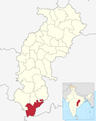
Dantewada District, also known as Dantewara District or Dakshin Bastar District, is a district in the Indian state of Chhattisgarh. Dantewada is the district headquarters. The district is part of Bastar Division. Until 1998, Dantewada District was a tehsil of the larger Bastar District.

<span class="mw-page-title-main">Jagdalpur</span> City in Chhattisgarh, India

Jagdalpur is a city located in the southern part of Chhattisgarh state in India. It is the administrative headquarters of the Bastar district and Bastar division. Before the independence of India, it also served as the capital of the erstwhile princely state of Bastar.

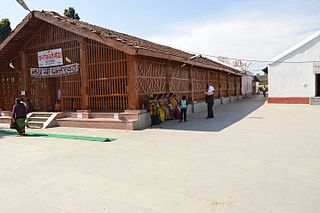
Dantewada is a town and a municipality, or nagar palika. in the Dantewada district in the state of Chhattisgarh, India.It is the administrative headquarters of Dantewada District. It is the fourth largest city of Bastar division. The town is named after the goddess Danteshwari, the presiding deity of the Danteshwari Temple located in the town, 80 km from the Jagdalpur town. The goddess is worshipped as an incarnation of Shakti and the temple is held to be one of the fifty-two sacred Shakti Peethas. Dantewada Town is well connected by broad gauge railway line from Visakhapatnam. The Nearest Big city to Dantewada is Raipur and well connected with Bus services

<span class="mw-page-title-main">Bastar division</span> Administrative division of Chhattisgarh State, India

Bastar division is an administrative division of Chhattisgarh state in central India. It includes the districts of Bastar, Dantewada, Bijapur, Narayanpur, Sukma, Kondagaon and Kanker.

<span class="mw-page-title-main">National Mineral Development Corporation</span> Indian public sector mining company

NMDC Limited, formerly National Mineral Development Corporation, is an Indian public sector undertaking involved in the exploration of iron ore, copper, rock phosphate, limestone, dolomite, gypsum, bentonite, magnesite, diamond, tin, tungsten, graphite, coal etc. It is India's largest iron ore producer and exporter, producing more than 35 million tonnes of iron ore from three mechanized mines in Chhattisgarh and Karnataka. It also operates the only mechanized diamond mine in the country at Panna in Madhya Pradesh.

<span class="mw-page-title-main">Bade Bacheli</span> City in Chhattisgarh, India

Bade Bacheli is a town and a Nagar Palika in Dantewada district in the state of Chhattisgarh, India. It is now very well known as NMDC Township with nature all around to explore and witness. It is situated roughly 400 km from Raipur, capital of Chhattisgarh. The way to travel is by Road with frequent bus service from Raipur, Bhilai, Jagdalpur, and Hyderabad, Visakhapatnam or by train from Jagdalpur and Vishakhapatnam.

Geedam is a census town and tehsil in Dantewada district in the state of Chhattisgarh, India. It is situated in National highway number 63 about 75 km from Jagdalpur. It is a town between the Bijapur-Jagdalpur NH63 route. About 15 km away from Dantewara City. It has a railway station about 3 km from the proper town and a helipad just 1km away from the town. Bus connectivity for Raipur, Jagdalpur City, Vishakapatnam City, Hyderabad City, Dantewara, Bijapur, Sukma, Bhopalpatnam, Barsoor and Kirandul is available.

The proposed Dalli Rajhara–Jagdalpur rail line, on paper for almost three decades, once completed, would connect Dalli Rajhara to Jagdalpur, both towns being in Chhattisgarh state in India. It would also connect Raipur, the capital city of Chhattisgarh, to Jagdalpur by rail via Durg. Jagdalpur, which is about 300 km from Raipur, is currently meaningfully connected to it only by road. There is though a roundabout rail route to reach Raipur from Jagdalpur via Koraput and Rayagada in Orissa; it is much longer and takes much longer time to be of any utility. In view of this, almost all the transport, in relation to both people and goods, between Raipur and Jagdalpur, happens only by road.

NMDC Steel Limited was formed under Government of India under Ministry of Steel with the help of NMDC's resources for setting up a 3 MTPA capacity greenfield Integrated Steel Plant based on Hi-Smelt technology in Nagarnar, located 16 km from Jagdalpur in Chhattisgarh state with an estimated outlay of Rs. 25500 crore. A pure-play miner, NMDC had in 2009-10 conceived the Nagarnar steel plant with the intention of moving up the value chain and diversifying its portfolio. The idea was also to hedge itself against the vagaries of iron ore prices. This is the only new large-scale steel plant currently fully ready to start production India, with little likelihood of a new plant of similar size plant coming up in the next few years. Tata Steel and JSW Steel are expanding capacity at their existing mills.

<span class="mw-page-title-main">Soni Sori</span> Indian activist and prisoner

Soni Sori is an Adivasi school teacher turned political leader of Aam Aadmi Party in Sameli village of Dantewada in south Bastar, Chhattisgarh, India. She was arrested by the Delhi Police's Crime Branch for Chhattisgarh Police in 2011 on charges of acting as a conduit for Maoists. During her imprisonment, she was tortured and sexually assaulted by Chhattisgarh state police. By April 2013, the Indian Courts had acquitted her in six of the eight cases filed against her due to lack of evidence. After release from prison, Sori began campaigning for the rights of those caught up in the conflict between Maoist insurgents and the government, in particular criticising police violence against tribespeople in the region.

<span class="mw-page-title-main">Kottavalasa Junction railway station</span> Railway station in Andhra Pradesh, India

Kothavalasa Junction railway station located in the Indian state of Andhra Pradesh, serves Kothavalasa in Vizianagaram district. It is a major freight transit point with iron ore rakes travelling from mines around Kirandul and Bailadila in Chhattisgarh to Visakhapatnam Port.

<span class="mw-page-title-main">Sukma district</span> District of Chhattisgarh in India

Sukma district is the southernmost district in the Indian state of Chhattisgarh. It is located in the Bastar region, known for its tribal culture. Sukma district borders with Odisha, Telangana and Andhra Pradesh.

<span class="mw-page-title-main">Kothavalasa–Kirandul line</span> Railway route in India

Kothavalasa–Kirandul line belongs to Waltair railway division of East Coast Railway zone. It was under South Eastern Railway zone until 2003. It passes through three states; Andhra Pradesh, Odisha and Chhattisgarh.

Dinesh Kashyap is an Indian politician and member of the Bharatiya Janta Party. He was a Member of Parliament from Bastar and also a Member of the Madhya Pradesh Legislative Assembly.

<span class="mw-page-title-main">Kirandul railway station</span> Railway station in Chhattisgarh

Kirandul railway station serves Kirandul, a city in the Dantewada district in the Indian state of Chhattisgarh.

<span class="mw-page-title-main">Tourism in Chhattisgarh</span>

Tourism is an important part of the economy of the Indian state of Chhattisgarh, India's tenth largest state. The state has many ancient monuments, rare wildlife, carved temples, Buddhist sites, palaces, water falls, caves, rock paintings and hill plateaus.

<span class="mw-page-title-main">Bailadila Range</span> Mountain range in India

Bailadila Range, is a mountain range rising in the Deccan Plateau about 200 km west of the Eastern Ghats. It has been named 'Bailadila' because it resembles the hump of an ox. It is located near Kirandul town in the Dantewada district of southern Chhattisgarh, India.

Antagarh is a town and a Nagar Panchayat located in the Kanker district of Chhattisgarh, India. It is the administrative headquarters of its eponymous development block, tehsil, and Assembly constituency.

References

  1. Postal Codes and Zip Codes Database – PostCodesDB
  2. District Dantewada Chhattisgarh – General Profile Archived 2007-04-09 at the Wayback Machine
  3. "Census of India 2011: Data from the 2011 Census, including cities, villages and towns". Census Commission of India. Retrieved 26 December 2017.
  4. The Journal of the Bombay Natural History Society – Google Books
  5. Bailadila Hills, Dantewada district, Chhattisgarh
  6. "District Dantewada Chhattisgarh - Tourism". dantewada.nic.in. Retrieved 3 November 2017.
  7. "Weatherbase: Historical Weather for Kirandul, India". Weatherbase. Retrieved 12 July 2013.
  8. Forbes India Magazine – Why Japanese Steel Companies Are In India
  9. NMDC Ltd. - Director Reports - money.livemint.com
  10. History of Kirandul City Chhattisgarh Origin-Background-Significance
  11. Buy NMDC; target Rs 138: ICICIdirect.com - Moneycontrol.com
  12. "It is like a bull hump in the hills". Dainik Bhaskar. Retrieved 28 December 2017.
  13. "NMDC to set up ore sampling laboratory at Kirandul mine". The Pioneer. Retrieved 28 December 2017.
  14. "Bailadila Iron Ore Project under CCTV". The Pioneer. Retrieved 29 December 2017.
  15. "NMDC Deposit 14 & 11C". NMDC website. Retrieved 29 December 2017.
  16. Railways hopes to make hay while sun shines – The Times of India
  17. "Govt targets Maoist jungle stronghold to win mining riches". Livemint.com. Retrieved 29 December 2017.
  18. "Comprehensive Industry document on Iron ore mining" (PDF). Central Pollution Control Board. Archived from the original (PDF) on 1 May 2013. Retrieved 28 December 2017.
  19. "Essar Steel begins work to reroute the longest slurry pipeline". Business Standard. Retrieved 30 December 2017.
  20. Waltair Division revenue crosses Rs. 5,000-crore mark - The Hindu
  21. Indian Railways – Google Books
  22. "Railways to fast-track doubling of KK line". The Times of India . Retrieved 8 July 2016.
  23. Kottavalasa-kirandul
  24. "A bridge too high poses unique challenge to Railways". The New Indian Express. Retrieved 28 December 2017.
  25. "NMDC assisting to double Kirandul Kottavalasa railway line". The Pioneer. Retrieved 28 December 2017.
  26. "Doubling of line between Kirandul Kottavalasa mooted". The Hindu. Retrieved 28 December 2017.
  27. Verma, Gargi. "Chhattisgarh: Bhupesh Baghel inaugurates airport in LWE-affected Jagdalpur".
  28. "Saturday Interview:Airports faced Covid challenges". The Statesman. Retrieved 17 January 2022.
  29. "Distance" . Retrieved 18 October 2012.
  30. "OmSai.Aero - Heliports". omsai.aero. Retrieved 7 November 2023.

Further reading