
Kollam, also known by its former name Quilon, is an ancient seaport and city on the Malabar Coast of India bordering the Laccadive Sea, which is a part of the Arabian Sea. It is 71 km (44 mi) north of the state capital Thiruvananthapuram. The city is on the banks of Ashtamudi Lake and the Kallada river. Kollam is the fourth largest city in Kerala and is known for cashew processing and coir manufacturing. It is the southern gateway to the Backwaters of Kerala and is a prominent tourist destination. Kollam is one of the most historic cities with continuous settlements in India. Geographically, Quilon formation seen around coastal cliffs of Ashtamudi Lake, represent sediments laid down in the Kerala basin that existed during Mio-Pliocene times.

The Kerala backwaters are a network of brackish lagoons and canals lying parallel to the Arabian Sea of the Malabar coast of Kerala state in south-western India. It also includes interconnected lakes, rivers, and inlets, a labyrinthine system formed by more than 900 km (560 mi) of waterways, and sometimes compared to bayous. The network includes five large lakes linked by canals, both man made and natural, fed by 38 rivers, and extending virtually half the length of Kerala state. The backwaters were formed by the action of waves and shore currents creating low barrier islands across the mouths of the many rivers flowing down from the Western Ghats range. In the midst of this landscape there are a number of towns and cities, which serve as the starting and end points of backwater cruises. There are 34 backwaters in Kerala. Out of it, 27 are located either closer to Arabian Sea or parallel to the sea. The remaining 7 are inland navigation routes.

Ashtamudi Lake, in the Kollam District of the Indian state of Kerala. It possesses a unique wetland ecosystem and a large palm-shaped water body, second only in size to the Vembanad estuary ecosystem of the state. Ashtamudi means 'eight hills or peaks' in the local Malayalam language. The name is indicative of the lake's topography with its multiple branches. The lake is also called the gateway to the backwaters of Kerala and is well known for its houseboat and backwater resorts. Ashtamudi Wetland was included in the list of wetlands of international importance, as defined by the Ramsar Convention for the conservation and sustainable utilization of wetlands.
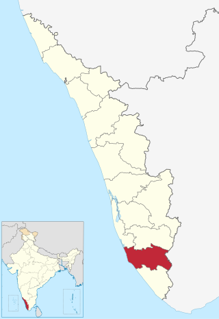
Kollam district, is one of 14 districts of the state of Kerala, India. The district has a cross-section of Kerala's natural attributes; it is endowed with a long coastline, a major Laccadive Sea seaport and an inland lake. The district has many water bodies. Kallada River is one among them, and land on the east bank of the river is East Kallada and that on the west bank is West Kallada.

Munroe Island or Mundrothuruthu is an inland island group located at the confluence of Ashtamudi Lake and the Kallada River, in Kollam district, Kerala, South India. It is a group of eight small islets comprising a total area of about 13.4 km2. The island, accessible by road, rail and inland water navigation, is about 25 kilometres (16 mi) from Kollam by road, 38 kilometres (24 mi) north from Paravur, 12 kilometres (7.5 mi) west from Kundara and about 25 kilometres (16 mi) from Karunagapally. As of the 2011 Indian census, the administrative village of Mundrothuruth has a total population of 9599, consisting of 4636 males and 4963 females. This island is also known as "Sinking Island of Kerala"

Paravur Kayal is a lake in Paravur, Kollam district, Kerala, India. Although it is small, with an area of only 6.62 km², it is the end point of the Ithikkara River and part of the system of lakes and canals that make up the Kerala Backwaters. It has been connected to Edava and Ashtamudi Kayal as part of the Trivandrum - Shoranur canal system since the late 19th century.
Karunagappally is a municipality in the Kollam district of Kerala, India. It is 24 km north of Kollam and 60 km (37 mi) south of Alappuzha. Karunagappally taluk consists of Alappad, Ochira, Adinad, Karunagappally, Thazhava, Pavumba, Thodiyoor, Kallalibhagom, Thevalakkara, Chavara, Neendakara, Clappana, Kulasekharapuram, Thekkumbhagam, Ayanivelikulangara, Panmana, Ponmana and Vadakumthala. The taluk is bound on the north by Kayamkulam, on the east by Kunnathur taluk, on the south by Kollam and on the west by the Arabian Sea. It is one of the fastest developing towns in Kerala and is part of Kollam metropolitan area.
Kundara is a census town in Kerala and is part of the Kollam Metropolitan Area, India. Kundara is situated 13 km east of Kollam city, 14 km west of Kottarakkara, and 24 km north of Paravur. Kundara is significant for its historic involvement in the Indian independence movement.

Anchalumoodu is a town and neighbourhood of the city of Kollam, India. It is a historic town near the place, where the Peruman railway accident happened in 1988. Anchalumoodu is 8 km away from Kollam city, 26 km from Paravur and 8 km from Kundara town. College of Engineering, Perumon is very close to this place. Anchalumoodu was a part of Thrikkadavoor till 2015. In May 2015, Government of Kerala have decided to expand City Corporation of Kollam by merging Thrikkadavoor panchayath. Now Anchalumoodu along with Thrikkadavoor is a part of Kollam city.

Kavanad is a suburban area of Kollam Municipal Corporation in Kerala. It is a major market town located at the northern suburb of Kollam City in India. It is coming under Sakthikulangara zone of Kollam Municipal Corporation. It is just 3 km from the port town of Neendakara. Kavanad, a narrow strip of land sandwiched between the Arabian Sea and the Ashtamudi Lake has one of the highest land values in Kollam city. The town emerged as a major shopping destination in Kollam with the advent of a number of shopping centres. A number of vehicle showrooms are also located at Kavanad-Ramankulangara-Mulamkadakam stretch. The long anticipated Kollam bypass starts just a kilometer before Kavanad from the place called Altharamoodu and was completed in January 2019, Kavanadu had become a major vantage point en route to Trivandrum from Alappuzha and is a fast developing satellite town within Kollam Metropolitan Area. You can also find 24 hr working shops in Kavanad which is a rarity in Kerala. Kavanadu is a major tourist attraction of Kollam district.
Chittumala is an urban settlement in Kollam district that is located on the Kundara - Bharanikkavu stretch of National Highway 183 besides Kallada River. The name Chittumala came from an old lady name chitta .
Hinduism, Islam and Christianity are the prominent religions in Kollam district. As per the Census 2011, out of the total population of 2,635,375 persons, 64.42% follow Hinduism, 19.30% follow Islam and 16.00% follow Christianity. Other religions comprise 0.04%, while 0.25% did not state any religion.

Tangasseri or Thangassery (Thangi) is a heavily populated beach area on the shores of the Arabian Sea in Kollam city, Kerala, India.
Panakkattodil Devi Temple is a Hindu temple in Chavara Thekkumbhagom village in Kollam district of the Indian state of Kerala. Primary deity of this temple is Durga. The temple is managed by the Travancore Devaswom Board, Kerala. The Thalappoli in 'Meda Bharani' and the annual festival during the months of April and May are popular.

Munroturuttu railway station or Mundrothuruthu railway station(Code:MQO) is an 'HG 2 Category' halt railway station, situated between Perinad and Sasthamkotta railway stations of Kollam district in Kerala state, India. The station is coming under the Southern Railway zone of Indian Railways. The nearest major rail head of Munrothuruthu railway station is Kollam Junction railway station.

Transport in Kollam includes various modes of road, rail and water transportation in the city and its suburbs. State-owned Kerala State Road Transport Corporation buses, private buses, Indian Railways, state-owned Kerala State Water Transport Department boats & ferry, taxis and auto rickshaws are serving the city of Kollam. The city had a strong commercial reputation since the days of the Phoenicians and Romans. Ibn Battuta mentioned Kollam Port as one of the five Indian ports he had seen during the course of his twenty-four year travels.

Kollam KSWTD Boat Jetty or Kollam KSWTD Ferry Station is an transport hub in the city of Kollam in Kerala, India, one of 14 ferry stations owned by the Kerala State Water Transport Department.

City of Kollam or Quilon is known as Prince of Arabian Sea, situated on the banks of Arabian Sea and Ashtamudi Lake. A major portion of Kollam Municipal Corporation area is occupied by Ashtamudi Lake. It is the most visited backwater and lake of Kerala, with a unique wetland ecosystem, a palm-shaped large water body, next only to the Vembanad estuary ecosystem of the state. Ashtamudi means 'eight coned'(Ashta = 'eight'; mudi = 'coned') in the local language of Malayalam. This name is indicative of the lake's topography: a lake with multiple branches. The lake is also called the gateway to the backwaters of Kerala. This lake is extremely famous for House Boat and Backwater Resorts.

City of Kollam or Quilon is a Port city in South India and was the commercial capital of erstwhile Kingdom of Travancore. It is situated on the Laccadive Sea coast of South Kerala. The city is known as the "Gateway to the backwaters of Kerala". The city lies on the banks of Ashtamudi Lake, Kerala's second largest lake, on the Arabian sea coast. Major parts of Kollam city are covered by Ashtamudi Lake.
Vellimon is a village situated in Perinad panchayath of Kollam district in Kerala, India. It is situated around 13 km away from district headquarters. Vellimon is a peninsular landmass of laterite soil that is protruding into Ashtamudi lake the peninsula is having a 20 metre high nearly continuous cliff facing backwaters. Farming, fishing and coir manufacturing are major activity in Vellimon. Chief cropping in the area is coconut. The population is overwhelmingly Hindus and there is visible lack of entrepreneurship and organised activities in the area. There were two resorts that came up in Vellimon namely Snehatheeram and Cambay Palm Lagoon. Due to lack of co-operation and anti social activities from local communities both were forced to shut down. Cambay Palm Lagoon was situated in the scenic laterite cliff that overlooks Munroe Island this resort is currently vandalised by miscreants.


