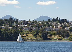
This article needs additional citations for verification .(March 2024) |
Ladysmith | |
---|---|
Town of Ladysmith [1] | |
![]() | |
Motto: Heritage by the Sea [2] | |
Location of Ladysmith in British Columbia | |
Coordinates: 48°59′43″N123°48′57″W / 48.99528°N 123.81583°W | |
Country | Canada |
Province | British Columbia |
Region | Vancouver Island |
Regional district | Cowichan Valley |
Incorporated | 1904 |
Government | |
• Governing body | Ladysmith Town Council |
• Mayor (acting) | Tricia McKay |
Area | |
• Total | 12.04 km2 (4.65 sq mi) |
Elevation | 40 m (130 ft) |
Population (2021) | |
• Total | 8,990 |
• Density | 746.5/km2 (1,933/sq mi) |
Time zone | UTC-8 (PST) |
• Summer (DST) | UTC-7 (PDT) |
Forward sortation area | |
Area code | 250 |
Highways | ![]() |
Website | www |
Ladysmith, originally Oyster Harbour, [3] is a town located on the 49th parallel north on the east coast of Vancouver Island, British Columbia, Canada. The local economy is based on forestry, tourism, and agriculture. A hillside location adjacent to a sheltered harbour forms the natural geography of the community.
As of 2021 [update] , the population was 8,990. The area of the town was 12.04 square kilometres. Total private dwellings were 4,079. Population density was 746.5 people per square kilometre. [4]
Ladysmith is served by the coast-spanning Island Highway, the Island Rail Corridor, nearby Nanaimo Airport and BC Ferries.
James Dunsmuir founded Ladysmith about 1898, a year after he built shipping wharves for loading coal at Oyster Harbour (now Ladysmith Harbour) from the mine at Extension, nearer Nanaimo. Dunsmuir, owner of coal mines in the Nanaimo area, needed a location to house the families of his miners. He chose to build the community at what was then known as Oyster Harbour, some 20 miles (32 km) south of his Extension mines. Many buildings were moved from Extension and Wellington by rail and by oxen.
In 1900, Dunsmuir renamed the town in honour of the British lifting the siege of Ladysmith in South Africa (28 February 1900) during the Second Boer War. (The original town of Ladysmith in turn took its name from Juana María de los Dolores de León Smith, known as Lady Smith, the Spanish wife of Sir Harry Smith, the British Governor of the Cape Colony and high commissioner in South Africa from 1847 to 1852. [3] ) The Town of Ladysmith was incorporated June 3, 1904. [3]
Dunsmuir thought this would be a fitting tribute at the conclusion of the Boer War (which ended in 1902). In addition to commemorating the end of the war by naming his town after Ladysmith, Dunsmuir also chose to name the streets of the community after British military personnel including: Field Marshall Lord Roberts, General John French, General Redvers Buller, General Sir Charles Warren, General Sir George White, Horatio Herbert Kitchener, Lieutenant-General Sir William Forbes Gatacre, Robert Stephenson Smyth Baden-Powell, Major General Lord Methuen, and Sir William Penn Symonds. The local high school yearbook was at one time called Spion Kop ("spy hill" in Afrikaans), in commemoration of the Battle of Spion Kop, a famous engagement in January 1900 in which the Boers defeated British troops during the Second Boer War. [5] [6]
Ladysmith experienced significant unrest and violence during the Vancouver Island coal miners' strike of 1912–1914. The miners were striking because of a variety of long-standing safety concerns. During the strike, militia were dispatched to put down unrest and protect property.
The Seaforth Highlanders of Canada first saw active service in the summer of 1912 when rallies by striking coal miners in the area around Nanaimo led to rioting. A company from the Seaforths was sent to garrison the area. Order was eventually restored and maintained until the unit was called back to mobilize for war in August 1914.[ citation needed ]
In 2017, Ladysmith's historic First Avenue was named the best street in Canada by the Canadian Institute of Planners. [7]
In the 2021 Census of Population conducted by Statistics Canada, Ladysmith had a population of 8,990 living in 3,926 of its 4,079 total private dwellings, a change of 5.3% from its 2016 population of 8,537. With a land area of 12.04 km2 (4.65 sq mi), it had a population density of 746.7/km2 (1,933.9/sq mi) in 2021. [8]
According to the 2021 census, religious groups in Ladysmith included: [9]
Panethnic group | 2021 [9] | 2016 [10] | 2011 [11] | 2006 [12] | 2001 [13] | 1996 [14] | 1991 [15] [16] | 1986 [17] [18] [19] : 101 | |||||||||||
---|---|---|---|---|---|---|---|---|---|---|---|---|---|---|---|---|---|---|---|
Pop. | % | Pop. | % | Pop. | % | Pop. | % | Pop. | % | Pop. | % | Pop. | % | Pop. | % | ||||
European [a] | 7,700 | 87.5% | 7,420 | 88.76% | 7,015 | 89.36% | 7,040 | 93.8% | 6,005 | 91.96% | 5,955 | 92.68% | 4,525 | 93.01% | 4,115 | 93.84% | |||
Indigenous | 625 | 7.1% | 665 | 7.95% | 440 | 5.61% | 310 | 4.13% | 325 | 4.98% | 330 | 5.14% | 235 | 4.83% | 135 | 3.08% | |||
East Asian [b] | 180 | 2.05% | 90 | 1.08% | 75 | 0.96% | 50 | 0.67% | 95 | 1.45% | 45 | 0.7% | 10 | 0.21% | 20 | 0.46% | |||
Southeast Asian [c] | 105 | 1.19% | 100 | 1.2% | 135 | 1.72% | 45 | 0.6% | 75 | 1.15% | 35 | 0.54% | 25 | 0.51% | 5 | 0.11% | |||
South Asian | 60 | 0.68% | 35 | 0.42% | 120 | 1.53% | 25 | 0.33% | 15 | 0.23% | 25 | 0.39% | 50 | 1.03% | 100 | 2.28% | |||
African | 55 | 0.63% | 25 | 0.3% | 20 | 0.25% | 10 | 0.13% | 10 | 0.15% | 25 | 0.39% | 10 | 0.21% | 0 | 0% | |||
Latin American | 25 | 0.28% | 10 | 0.12% | 0 | 0% | 10 | 0.13% | 10 | 0.15% | 0 | 0% | 10 | 0.21% | 10 | 0.23% | |||
Middle Eastern [d] | 0 | 0% | 10 | 0.12% | 25 | 0.32% | 0 | 0% | 10 | 0.15% | 0 | 0% | 0 | 0% | 0 | 0% | |||
Other/Multiracial [e] | 60 | 0.68% | 20 | 0.24% | 0 | 0% | 10 | 0.13% | 10 | 0.15% | 10 | 0.16% | — | — | — | — | |||
Total responses | 8,800 | 97.89% | 8,360 | 97.93% | 7,850 | 99.1% | 7,505 | 99.56% | 6,530 | 99.13% | 6,425 | 99.52% | 4,865 | 99.79% | 4,385 | 99.82% | |||
Total population | 8,990 | 100% | 8,537 | 100% | 7,921 | 100% | 7,538 | 100% | 6,587 | 100% | 6,456 | 100% | 4,875 | 100% | 4,393 | 100% | |||
Note: Totals greater than 100% due to multiple origin responses |
The Ladysmith-Chemainus Chronicle, a weekly community paper on Vancouver Island with a circulation of 1,898, has been printed locally and was founded in 1908. [20] [21] It is circulated in the communities of Ladysmith and Chemainus, in central Vancouver Island. [21] It is archived online in the Google news archive. [20]
Ladysmith Secondary School is the only secondary school in Ladysmith. The area has three elementary schools: Ladysmith Primary School (Kindergarten to Grade 3), Ladysmith Intermediate School (Grade 4 to Grade 7), and École North Oyster Elementary (Kindergarten to Grade 7). École North Oyster Elementary is a dual-track school, having both French immersion and English programs. Davis Road Elementary School (Kindergarten to Grade 7) was open from 1963 until June 2014 when it was closed due to being over capacity.
The Syfy original series Resident Alien is largely filmed within the town of Ladysmith. During production, many of the town's residents are employed as background performers. The town is transformed into the show's fictional setting of Patience, Colorado. Showrunner Chris Sheridan stated that production of the series is the subject of much attention and that residents often attempt to glean spoilers based on the observations of filming, leading certain scenes to be filmed at night. He furthermore detailed that while the filming does create disruptions such as the temporary closures of streets, the show's crew makes every effort to be as respectful as possible. [22]
The Alberni–Clayoquot Regional District of British Columbia is located on west central Vancouver Island. Adjacent regional districts it shares borders with are the Strathcona and Comox Valley Regional Districts to the north, and the Nanaimo and Cowichan Valley Regional Districts to the east. The regional district offices are located in Port Alberni.
The Township of Esquimalt is a municipality at the southern tip of Vancouver Island, in British Columbia, Canada. It is bordered to the east by the provincial capital, Victoria, to the south by the Strait of Juan de Fuca, to the west by Esquimalt Harbour and Royal Roads, to the northwest by the New Songhees 1A Indian reserve and the town of View Royal, and to the north by a narrow inlet of water called the Gorge, across which is the district municipality of Saanich. It is almost tangential to Esquimalt 1 Indian Reserve near Admirals Road. It is one of the 13 municipalities of Greater Victoria and part of the Capital Regional District.
Parksville is a city on Vancouver Island in British Columbia, Canada. As of the 2021 Census, Parksville's population was 13,642, representing a 9.5% increase over the 2016 Census.
View Royal is a town in Greater Victoria and a member municipality of the Capital Regional District of British Columbia, Canada. View Royal has a population of 11,575 residents. With over 700 hectares of parkland, View Royal includes Thetis, McKenzie, Pike, and Prior Lakes and portions of Esquimalt Harbour and Portage Inlet.
Golden is a town in southeastern British Columbia, Canada, 262 kilometres (163 mi) west of Calgary, Alberta, and 713 kilometres (443 mi) east of Vancouver.
Duncan is a city on southern Vancouver Island in British Columbia, Canada. It is the smallest city by area in Canada. It was incorporated in 1912.
The Municipality of the District of Lunenburg, is a district municipality in Lunenburg County, Nova Scotia, Canada. Statistics Canada classifies the district municipality as a municipal district.
North Cowichan is a district municipality established in 1873 on Vancouver Island, in British Columbia, Canada. The municipality is part of the Cowichan Valley Regional District. North Cowichan is noted for a landscape including forests, beaches, rivers, and lakes. The municipality encompasses the communities of Chemainus; Westholme; Crofton; Maple Bay; and "the South End". The latter is an informal name for a built-up area which is essentially a suburb of the City of Duncan, a separate municipality.
Lantzville is a coastal community on the east side of Vancouver Island, British Columbia, Canada, along the western shore of the Strait of Georgia and immediately north of Nanaimo.
The Regional District of Nanaimo is a regional district located on the eastern coast of Vancouver Island, British Columbia, Canada. It is bordered to the south by the Cowichan Valley Regional District, to the west by the Alberni-Clayoquot Regional District, and to the northwest by the Comox Valley Regional District. Its administration offices are located in Nanaimo. During the 2016 census, its population was established at 155,698.
The Cowichan Valley Regional District is a regional district in the Canadian province of British Columbia that is on the southern part of Vancouver Island, bordered by the Nanaimo and Alberni-Clayoquot Regional Districts to the north and northwest, and by the Capital Regional District to the south and east. As of the 2021 Census, the Regional District had a population of 89,013. The regional district offices are in Duncan.
The City of Enderby is in the North Okanagan region of the Canadian province of British Columbia, between Armstrong and Salmon Arm. It is approximately 80 km north of Kelowna and 130 km east of Kamloops. Highway 97A passes through Enderby and the Shuswap River marks the eastern and northeastern limits of the City. There are two major schools in Enderby: M.V. Beattie Elementary School and A.L. Fortune Secondary School. M.V. Beattie Elementary School was rebuilt in 2012.
Cumberland is an incorporated village municipality east of Perseverance Creek, near the east coast of central Vancouver Island, British Columbia. The Comox Valley community is west of BC Highway 19 and is by road about 105 kilometres (65 mi) northwest of Nanaimo and 10 kilometres (6 mi) southwest of Courtenay.
Port Hardy is a district municipality in British Columbia, Canada located on the north-east tip of Vancouver Island. Port Hardy has a population of 3,902 as of the 2021 census.
The demographics of Metro Vancouver indicate a multicultural and multiracial region. Metro Vancouver is a metropolitan area, with its major urban centre being Vancouver, British Columbia, Canada. The Vancouver census metropolitan area, as defined by Statistics Canada, encompasses roughly the same territory as the Metro Vancouver Regional District, a regional district in British Columbia. The regional district includes 23 local authorities. Figures provided here are for the Vancouver census metropolitan area and not for the City of Vancouver.
British Columbia is a Canadian province with a population of about 5.7 million people. The province represents about 13.2% of the population of the Canadian population. Most of the population is between the ages of 15 and 49. About 60 percent of British Columbians have European descent with significant Asian and Aboriginal minorities. Just under 30% of British Columbians are immigrants. Over half of the population is irreligious, with Christianity and Sikhism being the most followed religions.
Lake Cowichan is a town located near the eastern end of Cowichan Lake and, by highway, is a little over one hour northwest of Victoria, British Columbia. The town of Lake Cowichan was incorporated in 1944 and serves as the focal point of the Cowichan Lake Area, home to the indigenous c̓uubaʕsaʔtx̣ people. The Cowichan River flows through the middle of the town. The Cowichan River is designated as a Heritage River, and is also a popular location for tubing.
According to the 2021 census, the City of Edmonton had a population of 1,010,899 residents, compared to 4,262,635 for all of Alberta, Canada. The total population of the Edmonton census metropolitan area (CMA) was 1,418,118, making it the sixth-largest CMA in Canada.
In the 2021 Census, the City of Calgary had a population of 1,306,784 residents, representing 30.7% of the 4,262,635 residents in all of Alberta, and 3.5% compared to a population of 36,991,981 in all of Canada. The total population of the Calgary census metropolitan area (CMA) was 1,481,806. Calgary is the largest city in Alberta, and the third-largest municipality and fifth-largest metropolitan area in Canada, as of 2021.
Nanaimo—Ladysmith is a federal electoral district in British Columbia, in southeastern Vancouver Island.
[The newspaper] has written the events of councils and school boards as they served their communities.
Media related to Ladysmith, British Columbia at Wikimedia Commons