
Pathanamthitta District, is one of the 14 districts in the Indian state of Kerala. The district headquarters is in the town of Pathanamthitta. There are four municipalities in Pathanamthitta: Adoor, Pandalam, Pathanamthitta and Thiruvalla.

Kanjirappally is a taluk and a town in Kottayam district situated about 38 km (24 mi) away from the district capital, in the state of Kerala, in southwestern India.

Chengannur is a municipality in the Alappuzha district of Kerala, India. It is located 43 km (26.7 mi) south east of the district headquarters in Alappuzha and about 98 km (60.9 mi) north of the state capital Thiruvananthapuram. As per the 2011 Indian census, Chengannur has a population of 23,466 people, and a population density of 1,607/km2 (4,160/sq mi).

Ranni or Ranny is a town in the Pathanamthitta district of Kerala, India, and the 16th largest taluk in Kerala, located on both sides of the Pamba River.It Comes Under Thiruvalla Revenue Division.It Is located 27 km from Thiruvalla railway station & NH 183 in Thiruvalla.

Pathanamthitta, is a city in southern Kerala, India, spread over an area of 23.5 km2 (9.1 sq mi). It is the administrative capital of Pathanamthitta district. The town has a population of 37,538. The Hindu pilgrim centre Sabarimala is situated in the Pathanamthitta district; as the main transport hub to Sabarimala, the town is known as the 'Pilgrim Capital of Kerala'. Pathanamthitta District, the thirteenth revenue district of the State of Kerala, was formed with effect from 1 November 1982, with headquarters at Pathanamthitta. Forest covers more than half of the total area of the District. Pathanamthitta District ranks the 7th in area in the State. The district has its borders with Allepey, Kottayam, Kollam and Idukki districts of Kerala and Tamil Nadu. Nearest town is Thiruvalla, located at a distance of 30 km. Thiruvalla railway station is 30 km via Thiruvalla-Kumbazha highway.
Manimala is a small town and a village in Kottayam district in the Indian state of Kerala, situated about 12 kilometres (7.5 mi) from the nearest town Kanjirappally. It was declared a folklore village in 2011 by the central government to promote folklore.

Kulathupuzha is a town in the eastern part of Kollam district of Kerala, India. It is one of the important pilgrim spots linked with the legend of Sabarimala. It is the birthplace of the Malayalam music composer Raveendran. Kulathupuzha is the source of the Kallada river, Thenmala Dam (KIP) is located on this river. As declared by the Governor Arif Mohammad Khan, Kulathupuzha panchayat is the first in India to have achieved Constitution-literacy.

Erumely, also spelt Erumeli, is a town and panchayat located in the south-eastern part of Kottayam district in Kerala state, India. Erumely is situated 49 km (30 mi) east of Kottayam town and 133 km (83 mi) north of capital city Thiruvananthapuram. The village is on the Manimala River.
Mukkoottuthara is a developing Town located in the south eastern part of Kottayam district of Kerala State, India. Sabarimala is only 48 km (30 mi) from Erumely, while travelling through Mukkoottuthara. The roads passing through here are upgraded and maintained as State Highways. The main cultivation is rubber. Mukkoottuthara is famous for its decades old "Sunday Open Markets" and for its famous bamboo products. One of the famous tourist spots in Pathanamthitta, Perunthenaruvi Falls is just 5 kilometers from Mukkoottuthara. There are many rubber estates. The border of Kottayam and Pathanamthitta divides Mukkoottuthara into two. However the place is recorded as part of Kottayam district only.
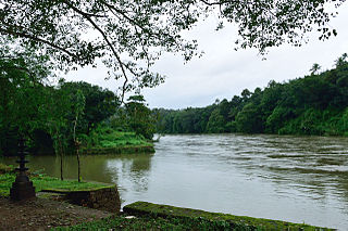
Perunad (Ranni-Perunad) is a scenic hilly village in Pathanamthitta district, Kerala state, India. Thiruvalla is the nearest railway station located at a distance of 58 km (36 mi). It's located on the banks of Pamba River and Kakkad River.

Chengara is a small village situated in the Pathanamthitta district in Kerala, India. It is known for its natural environment, hills and climate, and is found to have the cleanest air in terms of concentration of dust particles. Chengara is surrounded on three sides by Harrisons Malayalam Limited, a rubber plantation company.
Thiruvabharanam is the sacred ornaments of Ayyappan, the presiding deity of Sabarimala temple. The ornaments are made of gold. It is believed that these ornaments are made at the orders of the Pandalam King, who adopted Ayyappan as his child. Thiruvabharanam is kept at Srambickal Palace, which is close to the Valiyakoikkal Temple, inside the Pandalam Palace premises. At the end of the pilgrim season every year, the ornaments are taken to Sabarimala as a procession and poojas are performed on the idol adorned with the ornaments. After the season, the ornaments are taken back to the Srambickal Palace for safe custody. Thiruvabharanam and the caskets are made available for darshan at Srambickal palace during the pilgrim season and at Valiyakoikkal Temple on the day of the procession.

The Indian city of Thiruvananthapuram is located in Thiruvananthapuram district in the state of Kerala. The city is located at 8.5°N 76.9°E on the west coast, near the southern tip of mainland India. The city situated on the west coast of India, and is bounded by Arabian Sea to its west and the Western Ghats to its east. The city and the suburbs spans an area of 250 km2 (96.53 sq mi). The average elevation of the city is 16 ft above sea level. The highest point within the city limits is the observatory. Agastya Mala, which has an elevation of 1,868 metres (6,129 ft) is only about 60 km from the city. The Ponmudi hill station which has an elevation of 1,100 metres (3,609 ft) is also near the city.

Angamoozhy is a small village in Pathanamthitta district in the Indian state of Kerala. It is located near the Kakkad power station and the Sabarimala temple. Geographically, Angamoozhy is located in the Western Ghats mountain range.

Ponnambalamedu is where the fire lit event of Makaravilakku is conducted secretly by the Travancore Devaswom Board annually in the presence of nearly half a million pilgrims annually. It is a summit in the Western Ghat mountain ranges of Pathanamthitta District, Perunad grama panchayat, Kerala, India. It is located near the Sabarimala Ayyappan temple.

Chengannur railway station is an NSG–3 category Indian railway station in Thiruvananthapuram railway division of Southern Railway zone. It is located in Chengannur town of Kerala. It is one of the busiest stations in the Thiruvananthapuram Central–Kollam Junction–Kottayam–Ernakulam route, primarily due to the Sabarimala pilgrims. Chengannur railway station mainly serves the people of Alappuzha and Pathanamthitta district.
National Highway 183A, also known as NH 183A, is a National Highway in the Indian state of Kerala that runs from Chavara Titanium Junction, Kollam, to Vandiperiyar via Adoor and Pathanamthitta. It is the 4th National Highway passing through the Kollam district.

Nilakkal, also spelled Nilackal, is an important base camp of Sabarimala Hindu pilgrims located in Ranni tehsil of Pathanamthitta district in the Indian state of Kerala. Sabarimala temple is located at a distance of 23 km (14 mi) from Nilakkal.
Thulappally is a small village in Perunad panchayath of Ranni tehsil in Pathanamthitta district of Kerala state, India.
Sabari International Airport , also known as Sabarimala Airport, is a proposed greenfield international airport that will primarily cater to Sabarimala & Central Travancore Region. The proposed airport will also serve various tourism destinations such as Kumarakom, Thekkady, and cities such as Thiruvalla, Pathanamthitta & Kottayam. The airport will be built in between the towns of Erumeli South and Manimala. Thiruvalla Railway Station is the nearest railway Station to Airport -29 km. The proposed site is 50 km away from Pamba, which is the base camp of Sabarimala temple. The site is located at about 44 km from the city of Kottayam. The site is spread over 2,570 acres (10.4 km2) of area. It is 136 km from the state capital, Thiruvananthapuram, and 113 km from Kochi. Upon commissioning, this will be the fifth international airport in Kerala, giving the state the distinction of having the most international airports in India.

