Lake Nacimiento | |
---|---|
Nickname: The Dragon Lake | |
Coordinates: 35°44′15″N120°52′53″W / 35.73750°N 120.88139°W | |
Country | United States |
State | California |
County | San Luis Obispo |
Area | |
• Total | 10.291 sq mi (26.654 km2) |
• Land | 10.268 sq mi (26.594 km2) |
• Water | 0.023 sq mi (0.061 km2) 0.23% |
Elevation | 984 ft (300 m) |
Population (2020) | |
• Total | 2,956 |
• Density | 290/sq mi (110/km2) |
Time zone | UTC-8 (Pacific (PST)) |
• Summer (DST) | UTC-7 (PDT) |
ZIP code | 93446 |
Area code | 805 |
FIPS code | 06-39670 |
GNIS feature ID | 1867034 |
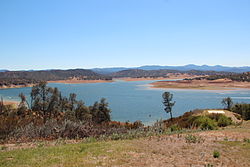
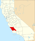
Lake Nacimiento is a census-designated place (CDP) in northern San Luis Obispo County, California, United States.
The population of Lake Nacimiento was 2,956 at the 2020 census, up from 2,411 at the 2010 census.
The community of Lake Nacimiento is located at Lake Nacimiento reservoir, in the Santa Lucia Mountains, at 35°44′15″N120°52′53″W / 35.73750°N 120.88139°W (35.737585, -120.881328). [2]
According to the United States Census Bureau, the CDP has a total area of 10.3 square miles (27 km2), 99.77% of it land and 0.23% of it water. The lake is often referred to as Dragon Lake, due to its unusual but distinct shape.
The Köppen Climate Classification subtype for this climate is "Csb" (Mediterranean Climate). [3]
Climate data for Lake Nacimiento, California | |||||||||||||
---|---|---|---|---|---|---|---|---|---|---|---|---|---|
Month | Jan | Feb | Mar | Apr | May | Jun | Jul | Aug | Sep | Oct | Nov | Dec | Year |
Mean daily maximum °F (°C) | 61 (16) | 64 (18) | 67 (19) | 72 (22) | 80 (27) | 89 (32) | 97 (36) | 97 (36) | 91 (33) | 81 (27) | 69 (21) | 62 (17) | 77 (25) |
Mean daily minimum °F (°C) | 35 (2) | 38 (3) | 39 (4) | 40 (4) | 44 (7) | 49 (9) | 51 (11) | 52 (11) | 50 (10) | 45 (7) | 40 (4) | 35 (2) | 43 (6) |
Average precipitation inches (mm) | 3.2 (81) | 2.9 (74) | 2.2 (56) | 1.2 (30) | 0.2 (5.1) | 0 (0) | 0 (0) | 0.1 (2.5) | 0.2 (5.1) | 0.6 (15) | 2 (51) | 2.4 (61) | 15 (380) |
Source: Weatherbase [4] |
Census | Pop. | Note | %± |
---|---|---|---|
U.S. Decennial Census [5] |
The 2010 United States Census [6] reported that Lake Nacimiento had a population of 2,411. The population density was 234.3 inhabitants per square mile (90.5/km2). The racial makeup of Lake Nacimiento was 2,153 (89.3%) White, 12 (0.5%) African American, 44 (1.8%) Native American, 24 (1.0%) Asian, 5 (0.2%) Pacific Islander, 75 (3.1%) from other races, and 98 (4.1%) from two or more races. Hispanic or Latino of any race were 256 persons (10.6%).
The Census reported that 2,411 people (100% of the population) lived in households, 0 (0%) lived in non-institutionalized group quarters, and 0 (0%) were institutionalized.
There were 1,006 households, out of which 272 (27.0%) had children under the age of 18 living in them, 581 (57.8%) were opposite-sex married couples living together, 67 (6.7%) had a female householder with no husband present, 45 (4.5%) had a male householder with no wife present. There were 66 (6.6%) unmarried opposite-sex partnerships, and 11 (1.1%) same-sex married couples or partnerships. 237 households (23.6%) were made up of individuals, and 69 (6.9%) had someone living alone who was 65 years of age or older. The average household size was 2.40. There were 693 families (68.9% of all households); the average family size was 2.83.
The population was spread out, with 489 people (20.3%) under the age of 18, 163 people (6.8%) aged 18 to 24, 549 people (22.8%) aged 25 to 44, 865 people (35.9%) aged 45 to 64, and 345 people (14.3%) who were 65 years of age or older. The median age was 45.1 years. For every 100 females there were 104.0 males. For every 100 females age 18 and over, there were 103.0 males.
There were 1,776 housing units at an average density of 172.6 units per square mile (66.6 units/km2), of which 771 (76.6%) were owner-occupied, and 235 (23.4%) were occupied by renters. The homeowner vacancy rate was 3.8%; the rental vacancy rate was 6.0%. 1,784 people (74.0% of the population) lived in owner-occupied housing units and 627 people (26.0%) lived in rental housing units.
As of the census [7] of 2000, there were 2,176 people, 904 households, and 676 families residing in the CDP. The population density was 293.1 inhabitants per square mile (113.2/km2). There were 1,283 housing units at an average density of 172.8 units per square mile (66.7 units/km2). The racial makeup of the CDP was 93.52% White, 0.32% African American, 1.33% Native American, 0.37% Asian, 1.06% from other races, and 3.40% from two or more races. Hispanic or Latino of any race were 7.31% of the population.
There were 904 households, out of which 26.9% had children under the age of 18 living with them, 64.6% were married couples living together, 6.2% had a female householder with no husband present, and 25.2% were non-families. 19.1% of all households were made up of individuals, and 6.1% had someone living alone who was 65 years of age or older. The average household size was 2.41 and the average family size was 2.74.
In the CDP the population was spread out, with 21.6% under the age of 18, 4.9% from 18 to 24, 26.3% from 25 to 44, 29.8% from 45 to 64, and 17.4% who were 65 years of age or older. The median age was 43 years. For every 100 females there were 102.6 males. For every 100 females age 18 and over, there were 103.1 males.
The median income for a household in the CDP was $54,958, and the median income for a family was $57,206. Males had a median income of $41,447 versus $34,219 for females. The per capita income for the CDP was $22,798. About 2.6% of families and 4.7% of the population were below the poverty line, including 3.9% of those under age 18 and 13.0% of those age 65 or over.
In the California State Legislature, Lake Nacimiento is in the 17th Senate District , represented by Democrat John Laird, and in the 35th Assembly District , represented by Democrat Jasmeet Bains. [8]
In the United States House of Representatives, Lake Nacimiento is in California's 24th congressional district , represented by Democrat Salud Carbajal. [9]
Shaver Lake is a census-designated place (CDP) in Fresno County, California, United States. The population was 634 at the 2010 census, down from 705 at the 2000 census. Shaver Lake is on the southwest end of the lake of the same name, 10 miles (16 km) east of New Auberry, at an elevation of 5,627 ft (1,715 m). The name honors C.B. Shaver, founder of the Fresno Flume and Irrigation Company that built the dam, creating the lake. The lake served as a mill pond for the Shaver Sawmill and the source for a flume that ran 65 miles (105 km) to Clovis. The original town of Shaver was buried under the lake when the Thomas A. Edison Company purchased and enlarged the lake in 1919.
Madera Acres is a census-designated place (CDP) in Madera County, California, United States. It is part of the Madera Metropolitan Statistical Area. The population was 9,162 at the 2020 census, virtually unchanged from 2010.
Bucks Lake is a census-designated place (CDP) in Plumas County, California, United States. Bucks Lake is located on the south shore of the lake of the same name, 13 miles (20.9 km) west-southwest of Quincy. The population was 22 at the 2020 census, up from 10 at the 2010 census.
Lake Almanor Country Club is a census-designated place (CDP) in Plumas County, California, United States. The population was 419 at the 2010 census, down from 847 at the 2000 census. The ZIP code for the CDP is 96137.
Lake Almanor Peninsula is a census-designated place (CDP) in Plumas County, California, United States. The population was 356 at the 2010 census, up from 336 at the 2000 census.
Lake Almanor West is a census-designated place (CDP) in Plumas County, California, United States. The population was 270 at the 2010 census, down from 329 at the 2000 census.
Stock Island is a census-designated place (CDP) and unincorporated community on an island of the same name in Monroe County, Florida, United States. The population of the CDP was 4,722 at the 2020 census, up from 3,919 in 2010. It is located on the portion of the island south of US 1. It is supposedly named for the herds of livestock formerly kept there. Alternatively, some local historians suggest that it may be named for an early settler.
North Vacherie is a census-designated place (CDP) in St. James Parish, Louisiana, United States. The population was 2,411 at the 2000 census. Vacherie was noted in the 2000 census as being the town with the least mobility of all in the United States.
China Lake Acres is a census-designated place (CDP) in Kern County, California, United States. The population was 1,876 at the 2010 census, up from 1,761 at the 2000 census.
Shorewood–Tower Hills–Harbert is a census-designated place (CDP) composed of several small unincorporated communities in Chikaming Township of Berrien County in the U.S. state of Michigan. The population was 1,249 at the 2020 census. The CDP is limited to Chikaming Township, although some of the communities extend into southern Lake Township. All of the communities are located either upon or just east of the dunes on the shore of Lake Michigan. Most of the communities lie west of Interstate 94, although the CDP includes a small area east of the freeway up to Sawyer, Michigan. The township is a popular resort destination.
Lakeland Village is a census-designated place (CDP) in Riverside County, California, United States. The population was 11,541 at the 2010 census, more than double the 5,626 reported at the 2000 census.
Collings Lakes is an unincorporated community and census-designated place (CDP) located within Buena Vista Township in Atlantic County, in the U.S. state of New Jersey. As of the 2010 United States Census, the CDP's population was 1,706.
Presidential Lakes Estates is an unincorporated community and census-designated place (CDP) located within Pemberton Township, in Burlington County, in the U.S. state of New Jersey. As of the 2010 United States Census, the CDP's population was 2,365.
Lake Telemark is an unincorporated community and census-designated place (CDP) located within Rockaway Township, in Morris County, in the U.S. state of New Jersey. As of the 2010 United States Census, the CDP's population was 1,255.
Cedar Glen Lakes is an unincorporated community and census-designated place (CDP) located within Manchester Township, in Ocean County, in the U.S. state of New Jersey. As of the 2010 United States Census, the CDP's population was 1,421.
Crandon Lakes is an unincorporated community and census-designated place (CDP) split between Hampton Township and Stillwater Township, in Sussex County, in the U.S. state of New Jersey. As of the 2010 United States Census, the CDP's population was 1,178, of which 682 were in Hampton Township and 496 in Stillwater Township.
Fairview-Ferndale is a census-designated place (CDP), located in Coal Township, in Northumberland County, Pennsylvania, United States. The population was 2,411 at the 2000 census.
Lake Stickney is a census-designated place (CDP) in Snohomish County, Washington, United States. The population was 15,413 at the 2020 census. The CDP was known as Paine Field-Lake Stickney prior to 2010. The new Lake Stickney CDP no longer contains the Paine Field airport.
Silver Lake is a former village and now a neighborhood within the village of Salem Lakes in Kenosha County, Wisconsin, United States. The population was 2,411 at the 2010 census, when the community was still an independent village. On February 14, 2017, the village merged with the town of Salem to create the village of Salem Lakes.
Oak Shores is a census-designated place in northern San Luis Obispo County, central California.