
St. George is a town in Knox County, Maine, United States. It includes the villages of Port Clyde and Tenants Harbor, with the latter being town's commercial center. A favorite with artists, writers and naturalists, St. George is home to the Brothers and Hay Ledge nature preserve, comprising four islands off Port Clyde. The town's population stands at 2,594 residents, according to the 2020 Census.

The Stellafane Observatory is an astronomical observatory in Springfield, Vermont, founded in 1920 by Russell W. Porter. The Pink Clubhouse was built in 1923 at the site by the Springfield Telescope Makers Club. The name Stellafane, suggested by Porter at the club's December 1923 meeting, is derived from the Latin words stella and fanum meaning "Shrine to the Stars", and originally referred specifically to the clubhouse, but has since come to refer to all of the club's land and buildings on the summit of Breezy Hill, west of downtown Springfield.
Russell Williams Porter was an American artist, engineer, amateur astronomer and Arctic explorer. He was a pioneer in the field of “cutaway illustration" and is sometimes referred to as the "founder" or one of the "founders" of amateur telescope making."

Port Clyde is the southernmost settlement on the St. George peninsula in central/coastal Maine and part of the town of St. George in Knox County, Maine, United States. The ZIP Code for Port Clyde is 04855.
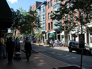
The Old Port is a district of Portland, Maine, known for its cobblestone streets, 19th-century brick buildings and fishing piers. The district contains boutiques, restaurants and bars. Because of its reputation for nightlife, the Old Port is a popular destination for tourists and locals alike.

The History of Portland, Maine begins when Native Americans originally called the Portland peninsula Məkíhkanək meaning “At the fish hook” in Penobscot and Machigonne in Algonquian. The peninsula and surrounding areas was home to members of the Algonquian-speaking Aucocisco branch of the Eastern Abenaki tribe who were forcibly relocated to current day Canada during European settlement.

Marshall Point Light Station is a lighthouse at the entrance of Port Clyde Harbor in Port Clyde, Maine. The light station was established in 1832.

The Main Street–Frye Street Historic District is a historic district comprising houses on Frye Street and parts of College Street and Main Street in Lewiston, Maine. This area was part of the most fashionable residential district of the city in the second half of the 19th century, and was home to many of the city's elite. Its architectural styles are diverse, with a significant number of homes designed by local architect George M. Coombs. The district was added to the National Register of Historic Places in 2009.
The Harbor Lane–Eden Street Historic District encompasses a neighborhood of Bar Harbor, Maine, consisting of architect-designed summer estates that served as the summer of elite society families of the late 19th and early 20th centuries. Located northwest of the main village and fronting on Frenchman Bay, the district includes nine summer houses that survived a devastating 1947 fire which destroyed many other summer estates. The district was listed on the National Register of Historic Places in 2009.

The East River Road Historic District is a historic district located along East River Road near the Grosse Ile Parkway in Grosse Ile, Michigan. The district is a small island community composed of eleven structures, including seven houses, two outbuildings, St. James Episcopal Church, and the Michigan Central Railroad depot. The district stretches from St. James Episcopal Church on the south to Littlecote on the north. The district was designated a Michigan State Historic Site in 1972 and listed on the National Register of Historic Places in 1973. The historically significant 1870s customs house was moved into the district in 1979.

The Hudson Historic District is a historic district located in Hudson, Ohio. It was added to the National Register of Historic Places in 1973.

The Western Promenade Historic District encompasses a large late 19th- and early 20th-century neighborhood in the West End of Portland, Maine. This area of architecturally distinctive homes was home to three of the city's most prominent architects: Francis H. Fassett, John Calvin Stevens, and Frederick A. Tompson, and was Portland's most fashionable neighborhood in the late 19th century. The district was listed on the National Register of Historic Places in 1984.
The Harraseeket Historic District encompasses some of the oldest maritime village areas of the town of Freeport, Maine. It includes properties along both banks of the tidal Harraseeket River, from the Mast Landing area in the north to Wolf Neck and the villages of Porter Landing and South Freeport on the west bank of the river. The district was listed on the National Register of Historic Places in 1974.

The Castine Historic District encompasses the entire southern tip of the peninsula on which the town of Castine, Maine is located. Covering about 1,800 acres (730 ha), this area was a center of colonial conflicts dating to the early 17th century, and was the site of military action during the American Revolutionary War and the War of 1812. Bypassed by the railroads, it has retained a village feel reminiscent of the early 19th century. It was listed on the National Register of Historic Places in 1973.
The Kineo Cottage Row Historic District encompasses a collection of seven summer resort cottages on the Mount Kineo peninsula, which juts into Moosehead Lake in central Maine. The cottages were built between 1900 and 1912 as part of the Mount Kineo resort complex, one of interior Maine's most successful summer resorts of the early 20th century, and are its only major surviving component. The cottages were listed on the National Register of Historic Places in 2004.
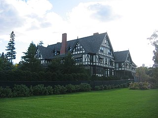
The John Innes Kane Cottage, also known as Breakwater and Atlantique, is a historic summer estate house at 45 Hancock Street in Bar Harbor, Maine. Built in 1903-04 for John Innes Kane, a wealthy grandson of John Jacob Astor and designed by local architect Fred L. Savage, it is one of a small number of estate houses to escape Bar Harbor's devastating 1947 fire. An imposing example of Tudor Revival architecture, it was listed on the National Register of Historic Places in 1992.

The Salmon Falls (East) Historic District encompasses a node of rural development in western Buxton, Maine. It includes thirteen historic properties, mainly Greek Revival in character, extending north along Maine State Route 117, north of its junction with Simpson Road, and two on the latter street, that were all built between about 1800 and 1850. The district was listed on the National Register of Historic Places in 1987.

The Auburn–Harpswell Association Historic District encompasses a well-preserved enclave of summer residences built in the early 20th century in southern Harpswell, Maine. The district includes ten Shingle style houses, a Colonial Revival dining hall, and a Greek Revival meeting hall. The Auburn Colony, an exclusive company of businessmen from Auburn, Maine, was responsible for their development. The district was listed on the National Register of Historic Places in 1985.
The George S. Tiffany Cottage is a historic summer house on Aldrich Road in Islesboro, Maine. Built 1911-12 for a businessman from St. Louis, Missouri, it is a rare example in the state of the Prairie School of architecture. It was listed on the National Register of Historic Places in 1989.

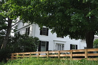
The Sproul Homestead is a historic house on Maine State Route 129 in southern Bristol, Maine. It consists of a c. 1815 Federal period building, which was joined to a c. 1749 colonial Cape style house. Both sections were built by members of the locally prominent Sproul family. The house was listed on the National Register of Historic Places in 1978.


