Berkeley Plantation, one of the first plantations in America, comprises about 1,000 acres (400 ha) on the banks of the James River on State Route 5 in Charles City County, Virginia. Berkeley Plantation was originally called Berkeley Hundred and named after the Berkeley Company of England. Benjamin Harrison IV built on the estate what is believed to be the oldest three-story brick mansion in Virginia and is the ancestral home to two Presidents of the United States: William Henry Harrison, his grandson, and Benjamin Harrison his great-great-grandson. It is now a museum property, open to the public.

Conway Cemetery State Park is a 11.5-acre (4.7 ha) Arkansas state park in Lafayette County, Arkansas in the United States. Located on the former cotton plantation grounds of James Sevier Conway, the cemetery serves as Conway's final resting place. No recreational or visitors' amenities are available at the historic site. The site became a state park in 1986 as part of Arkansas's sesquicentennial.

Little Rock National Cemetery is a United States National Cemetery, located two miles (3 km) south of the city of Little Rock, in Pulaski County, Arkansas. It encompasses 31.7 acres (12.8 ha), and as of the end of 2005, had 25,172 interments. Administered by the United States Department of Veterans Affairs, it is currently closed to new interments.

The Louisiana Purchase Historic State Park commemorates the initial point from which the lands acquired through the Louisiana Purchase (1803) were subsequently surveyed. The protected area encompasses 37.5 acres (15.2 ha) of forested wetlands, a landform which is regionally in decline due to agricultural development practices that include draining such areas. In the center of the park is a 6-foot (1.8 m) marker erected in 1926 on the survey point by the L'Anguille Chapter of the Daughters of the American Revolution. The site was listed on the National Register of Historic Places (1972) and designated as a National Historic Landmark (1993).

Hampton Plantation, also known as Hampton Plantation House and Hampton Plantation State Historic Site, is a historic plantation, now a state historic site, north of McClellanville, South Carolina. The plantation was established in 1735, and its main house exhibits one of the earliest known examples in the United States of a temple front in domestic architecture. It is also one of the state's finest examples of a wood frame Georgian plantation house. It was declared a National Historic Landmark in 1970.

Mulberry Plantation, also known as the James and Mary Boykin Chesnut House is a historic plantation at 559 Sumter Highway south of Camden, South Carolina. Declared a National Historic Landmark in 2000, it is significant as the home of American Civil War chronicler Mary Boykin Chesnut, who produced some of the most important written accounts of the war from a Confederate perspective. The main house, built about 1820, is a fine example of Federal period architecture.

Fort Logan H. Roots was a military base located in North Little Rock, Arkansas, set on a high promontory overlooking the Arkansas River. The land was traded to the Federal Government in 1892 in exchange for the property now known as MacArthur Park, in Little Rock, which had been a military arsenal since the 1830s when Arkansas was a territory. The base was named for Congressman Logan H. Roots in recognition for his work in the negotiations.

The Goode–Hall House, also commonly known as Saunders Hall, is a historic plantation house in the Tennessee River Valley near Town Creek, Alabama. It was added to the National Register of Historic Places on October 1, 1974, due to its architectural significance.

The Stafford Plantation was a plantation on Cumberland Island in Camden County, on the southeastern coast of Georgia. It was established in the early 19th century by Robert Stafford.

Ormonde (1885–88) is a Shingle Style country house built on the eastern shore of Cazenovia Lake in Cazenovia, New York. It was designed by architect Frank Furness for George R. Preston, a New Orleans banker who settled in Philadelphia, Pennsylvania.
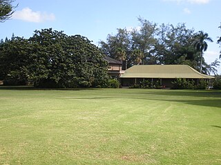
Grove Farm is a historic agricultural site on Kauai in the Hawaiian Islands.

The H. G. W. Mayberry House, also known as Beechwood Hall, is a historic antebellum plantation house built in 1856 in Franklin, Tennessee.

The Fighting Creek Plantation is a historic plantation house at 1811 Mill Quarter Road in Powhatan, Virginia. It is one of a few surviving mid-19th century plantation houses in the state. The two story stucco manor house was built c. 1841, supposedly to a design by New York architect Alexander Jackson Davis. It was built for John Brockenbrough Harvie and his wife as the main house of their nearly 1,700-acre (690 ha) plantation. The property now associated with the house has been reduced to just 4.3 acres (1.7 ha). Its main facade features a two-story portico with square Doric columns, topped by a pedimented gable. On each level under the portico there is a door, with round-arch windows flanking it on either side.

Landsford Plantation House, also known as the Davie House, is a historic plantation house located near Richburg, Chester County, South Carolina. It was built about 1828, and is a 2 1/2-story, timber-framed weatherboarded vernacular residence. The house has a square plan and is two rooms deep. The main façade featured a one-story porch, resting on brick piers, and added about the turn of the 20th century. Landsford Plantation achieved local prominence as the social center of a 3,000 acres (1,200 ha) Piedmont cotton plantation in the mid-19th century. Of the original outbuildings, only a barn of log construction remains.

Oakland Farm is a historic farmhouse at the northern end of Oakland Street in Camden, Arkansas. The 1-1/2 story cypress house was built in 1886, and stands on one of the largest and most prominent estates in Camden. The house was built by William Frank Tate, descendant of Ouachita County's first English settler, John Tate, and remains in the Tate family. It has a T shape, with a main block and a series of additions which give it that shape. A veranda supported by Doric columns spans the width of the main facade.

The Ford–Countess House is a historic residence near Huntsville in Madison County, Alabama. Hezekiah Ford came to Madison County from Cumberland County, Virginia, in 1813, and began purchasing land on which to build a cotton plantation. He acquired the land on which the house stands in 1820, and built the two-story, brick I-house soon after. Ford died in 1839, and the land was owned by his wife, Nancy, until her death in 1844. Hezekiah's brother, John, then assumed ownership, and the plantation stayed in his family until 1904. It reached a peak of 280 acres, and the family owned 69 slaves in 1860. James W. Burcum owned the property from 1904 until 1911, when it was sold to Stephen H. Countess of Tuscaloosa. The Countess family still owns and farms the land, although the house has not been occupied since 1995.

Twelve Oaks, or the J.W. Bass House, is a historic farm estate at 7210 Arkansas Highway 7 South in rural Boone County, Arkansas, south of Harrison. The main house is a dramatic and architecturally eclectic two-story building with a variety of Craftsman, Colonial Revival, and Mission style details. It is a stucco-finished concrete construction, whose roof has exposed rafter tails, and was originally finished in tile, replaced after a 1973 tornado extensively damaged the property. At the time of its construction in 1922, it was one of the finest plantation houses in the state. It was built by J. W. Bass, a businessman responsible for the construction of a number of Harrison's finest buildings, who developed a 1,600-acre (650 ha) farm south of the city, with this property as its centerpiece. It was named "Twelve Oaks" after a grove of twelve large oak trees, none of which survived the 1973 tornado.

The Cherry-Luter Estate is a historic country estate, also known as The Castle, at 521 West Scenic Drive in North Little Rock, Arkansas. The main house is a two-story French Renaissance limestone structure with a gabled roof and round tower at its southwest corner. A carriage house of similar construction stands nearby, and there is a pavilion with a half-timbered roof with exposed beams. A stone wall lines the road at the edge of the property, which is just under 5 acres (2.0 ha) in size. The estate was largely developed by 1923 by John J. Cherry, and is one of the city's architectural landmarks.

The Bayou Meto Battlefield is a battlefield site of the American Civil War in Jacksonville, Arkansas. It is the location of the August 27, 1863 Battle of Bayou Meto, in which Confederate forces successfully prevented Union Army forces from crossing the Bayou Meto River during their advance to capture Little Rock. The battlefield is located on both sides of the river, on either side of Arkansas Highway 161, whose bridge is the location of the 1863 Reed's Bridge. A portion of the battlefield is now preserved as Reed's Bridge Battlefield Heritage Park. The entire battlefield is the best-preserved of the three major battle sites of the Union advance on Little Rock. A 412-acre (167 ha) area covering the core of the battlefield was listed on the National Register of Historic Places in 2002.

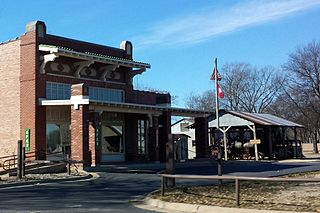
The Seed Warehouse No. 5 is a historic seed storage facility, now located on the grounds of the Plantation Agriculture Museum, a state park in Scott, Arkansas. It is a long rectangular structure, with walls that slope inward as they rise to a gable roof. The roof is topped by a series of gabled cupolas, each with windows and louvered openings. The main entrance is at one end, in a projecting gabled section. All of the exterior walls are corrugated metal. Built in 1948 by a prominent local cotton farmer, it is a well-preserved example of a modern mid-20th century cotton seed storage facility. It was acquired by the state in 1985 for the museum, underwent restoration in 2008, and now houses museum exhibits.