Spring Hill is the name of a ridge in the central part of the city of Somerville, Massachusetts, and the residential neighborhood that sits atop it. It runs northwest to southeast, roughly bounded by Highland Avenue, Somerville Avenue, Elm Street, and Willow Avenue. Summer Street runs along the hill's crest.

Several neighborhoods of Norwich, Connecticut maintain independent identities and are recognized by official signs marking their boundaries. The following is a list of neighborhoods in Norwich.

The city of Davenport, Iowa, United States has neighborhoods dating back to the 1840s. The Davenport Plan and Zoning Commission divided the city into five areas: downtown, central, east end, near north, and northwest and west end. The neighborhoods contain many architectural designs, including Victorian, Queen Anne, and Tudor Revival. Many of the original neighborhoods were first inhabited by German settlers.

The South Britain Historic District encompasses the core of the unincorporated village of South Britain in Southbury, Connecticut, United States. The village arose in the 18th century as an industrial center serving the surrounding agricultural community, powered by the Pomperaug River, and rivalled the town center of Southbury in importance. The district was listed on the National Register of Historic Places in 1987.
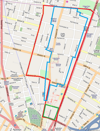
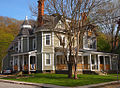
Prospect Hill is a neighborhood of the city of New Haven, Connecticut located in the north central portion of the city, directly north of Downtown New Haven. The neighborhood contains residences, institutional buildings of Albertus Magnus University and a portion of the main campus of Yale University, including the Science Hill area, the Hillhouse Avenue area and the Yale Peabody Museum. The City of New Haven defines the neighborhood to be the region bounded by the town of Hamden in the north, Winchester Avenue in the west, Munson Street/Hillside Place/Prospect Street in the southwest, Trumbull Street in the south, and Whitney Avenue in the east. Prospect Street is the main thoroughfare through the neighborhood.
The Prospect Hill Historic District is an irregularly-shaped 185-acre (75 ha) historic district in New Haven, Connecticut. The district encompasses most of the residential portion of the Prospect Hill neighborhood.

Norwichtown is a historic neighborhood in the city of Norwich, Connecticut. It is generally the area immediately north of the Yantic River between I-395 and Route 169.

Newington Junction is a section of the town of Newington, Connecticut. It is centered at the intersection of Willard Avenue and West Hill Road in the northwestern part of the town, in the area generally just south of the Hartford city line. The name of the area refers to the railroad junction where the railroad line from New Haven meets with the railroad line from Bristol and Waterbury. The development of Newington Junction as a result of the railroad was instrumental in the separation of the town of Newington from its mother town of Wethersfield.
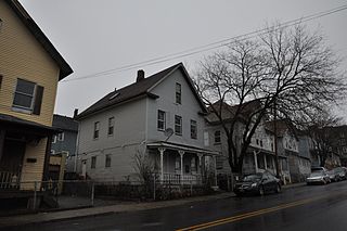
The Sterling Hill Historic District in Bridgeport, Connecticut is a historic district that was listed on the National Register of Historic Places in 1992. The district is a two-block area of 43 urban residential structures dating as far back as 1821. Most of the buildings are from later in the 19th century when the neighborhood was largely occupied by Irish working-class residents. Most of the early buildings are vernacular wood-frame structures with modest Federal, Greek Revival, or Gothic Revival details, while the later additions include multiunit tenement-style buildings. The area includes the oldest urbanized part of the city.
The American Thermos Bottle Company Laurel Hill Plant, located in the Laurel Hill section of Norwich, Connecticut, in the United States, includes 11 contributing buildings and two other contributing structures. The original plant was built during 1912–13 and used a historic Italianate house as a company office building. The plant was the primary factory where Thermos brand vacuum flask bottles were manufactured from 1913 to 1984. The plant is historically significant to its connection to the Thermos Company and the history of Norwich. The complex is architecturally significant because it displays the adaptive use of industrial mill design to new industry. It was added to the National Register of Historic Places in 1989.
The Chelsea Parade Historic District encompasses a predominantly residential area north of downtown Norwich. Centered around the Chelsea Parade, a triangular public park, the area has long been a preferred residential area for the city's upper classes, and includes a catalog of architecture from the 18th to 20th centuries. It includes 565 contributing buildings, two other contributing sites, and six contributing objects over an area of 205 acres (83 ha). The district was listed on the National Register of Historic Places in 1989.

Greeneville is a neighborhood of the city of Norwich, Connecticut, located northeast of downtown Norwich along the west bank of the Shetucket River. Most of the neighborhood is designated Greeneville Historic District, a historic district that is listed on the National Register of Historic Places.

The Hillside Historic District in Waterbury, Connecticut is a 106-acre (43 ha) historic district that was listed on the National Register of Historic Places (NRHP) in 1987. It encompasses a residential area north of the city's central business district, and is bounded on the south by West Main Street, the west by Willow Avenue and Cliff and Frederick Streets, on the north by Buckingham Street and Woodland Terrace, and on the east by Cooke Street. Developed principally over an 80-year period between 1840 and 1920, it includes a cross-section of architectural styles of the 19th and early 20th centuries. The area was a desirable neighborhood of the city for much of this time, and was home to a number of the city's elite. In 1987, it included 395 buildings deemed to contribute to the historic character of the area, and one other contributing structure. It includes the Wilby High School and the Benedict-Miller House, which are both separately listed. 32 Hillside Road, a several acre property that includes the Benedict Miller House, was the original site of The University of Connecticut's Waterbury Branch until 2003.
The Jail Hill Historic District encompasses a 19th-century working-class residential district in Norwich, Connecticut. Located on a steep hill overlooking downtown Norwich, it was populated first by African Americans, and then by Irish immigrants. Some early African-American residents played significant roles in bringing expanded rights and education to others. The district was added to the National Register of Historic Places on April 19, 1999.

The Little Plain Historic District is a predominantly residential historic district located in Norwich, Connecticut. When originally listed in 1970, it was centered on Little Plain Park, located about halfway between modern downtown Norwich and the Norwichtown green, the colonial center of the town. From the late 18th century onward this area became a desirable and fashionable area to live, as it was closer to the growing port area of the city. The area was mostly built out by about 1875, and features a rich concentration of Greek Revival, Gothic Revival and Italianate houses, although older and later styles are also represented. The district was listed on the National Register of Historic Places in 1970 and enlarged in 1987. The 1987 enlargement expanded the district southward along Union Street and Broadway, to abut the Downtown Norwich Historic District, and increased the district's size from 30 acres (12 ha) to 38.8 acres (15.7 ha).

The Bridge Avenue Historic District is located in a residential neighborhood on the east side of Davenport, Iowa, United States. It has been listed on the National Register of Historic Places since 1983. The historic district stretches from River Drive along the Mississippi River up a bluff to East Ninth Street, which is near the top of the hill.

The Collins and Townley Streets District is a historic district encompassing a cluster of mid-to-late 19th-century residences in the Asylum Hill neighborhood of Hartford, Connecticut. It includes properties on Collins, Atwood, Willard, and Townley Streets, which range architecturally from the Italianate and Second Empire of the 1860s and 1870s to the Shingle style of the 1890s. The district was listed on the National Register of Historic Places in 1979.

The Imlay and Laurel Streets District is a residential historic district on portions of Imlay, Laurel, Hawthorn and Sigourney Streets in Hartford, Connecticut. The area is a densely built residential neighborhood developed between about 1870 and 1895, with predominantly brick Italianate and Queen Anne construction. The district was listed on the National Register of Historic Places in 1979.

The Walnut Hill District is a historic district encompassing a predominantly residential area southwest of downtown New Britain, Connecticut. Roughly bounded by Walnut Hill Park and the New Britain General Hospital, as well as West Main, Main, Arch, and Hart Streets, the area mirrors in residential architecture the growth of the city as an industrial center between 1840 and 1930. The district was listed on the National Register of Historic Places in 1975.

The Stratfield Historic District is a historic residential area on the west side of Bridgeport, Connecticut. In the late 19th and early 20th century, it was one of the highest-status and most fashionable neighborhoods in the city. At more than 100 acres (40 ha) in size, it is one of the largest assemblages of high-status residential architecture in the state. It was listed on the National Register of Historic Places in 1980.