Related Research Articles

County Clare is a county in Ireland, in the Mid-West Region and the province of Munster, bordered on the west by the Atlantic Ocean. Clare County Council is the local authority. The county had a population of 118,817 at the 2016 census. The county town and largest settlement is Ennis.

Loughrea is a town in County Galway, Ireland. The town lies to the north of a range of wooded hills, the Slieve Aughty Mountains, and the lake from which it takes its name. The town's cathedral, St Brendan's, dominates the town's skyline. The town has increased in population in the late 20th and early 21st centuries. Although the town also serves as a commuter town for the city of Galway, it also remains an independent market town.

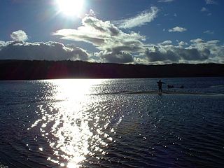
Mountshannon is a village in east County Clare, Ireland, and a Catholic parish by the same name. The village is on the western shore of Lough Derg, north of Killaloe. Mountshannon won the Irish Tidy Towns Competition in 1981.
The Conmhaícne Mara or Conmaicne Mara, were an early people of Ireland. Their tuath was located in the extreme west of County Galway, Republic of Ireland, giving their name to Connemara, an anglicised form of Conmhaicne Mara.
Clare–Galway South was a parliamentary constituency represented in Dáil Éireann, the lower house of the Irish parliament or Oireachtas from 1969 to 1977. The constituency elected 3 deputies to the Dáil, using the single transferable vote form of proportional representation (PR-STV).
Ogonnelloe is a Catholic parish and civil parish in east County Clare, Ireland, situated on the R463 regional road between Scariff and Killaloe and in the surrounding hills.
Tynagh is a village and electoral division in south-east County Galway in Ireland.
Galway South was a parliamentary constituency represented in Dáil Éireann, the lower house of the Irish parliament or Oireachtas from 1948 to 1961. The constituency elected 3 deputies to the Dáil, using the single transferable vote form of proportional representation (PR-STV).
The Conmhaícne Mheáin Maigh or Conmaicne Mhein or Conmaicne Máenmaige or Conmaicne Críche Meic Erca, were an early people of Ireland, their tuath comprising the barony of Loughrea, in County Galway.

Inis Cealtra, or Holy Island, is an island off the western shore of Lough Derg in Ireland. Now uninhabited, it was once a monastic settlement. It has an Irish round tower, and the ruins of several small churches, as well as part of 4 high crosses and a holy well. Despite the lack of population, the cemetery on this island is still in use. Coffins and mourners are transported the short distance from County Clare in small boats. Boat trips can be taken from the harbour at Mountshannon. It is conserved by the East Clare Heritage Centre.

Iveagh Upper, Lower Half is the name of a barony in County Down, Northern Ireland. It was created by 1851 with the division of the barony of Iveagh Upper into two. It lies in the centre of the county, and is bordered by six other baronies: Iveagh Upper, Upper Half and Lordship of Newry to the west; Mourne to the south; Kinelarty and Lecale Upper to the east; and Iveagh Lower, Upper Half to the north.
Tulla Upper is a barony in County Clare, Ireland. This ancient geographical division of land is in turn divided into seven civil parishes.
Killanena is a townland and formerly a District Electoral Division (DED) in County Clare, Ireland, in the Catholic parish of Killanena and Flagmount.
Inishcaltra is a civil parish in the barony of Leitrim in County Clare, Ireland. The main settlement in the parish is the village of Mountshannon. It is noted for the eponymous island of Inis Cealtra, which is an ancient Christian monastic site. In the Catholic Church, the parish is part of the ecclesiastical parish of Mountshannon (Clonrush).
Clonrush or Clonmulsk is a civil parish in the barony of Leitrim in County Clare, Ireland. The largest settlement in the parish is Whitegate. In the Catholic Church, the parish is joined with Mountshannon.
The baronly of Leitrim is a barony in County Leitrim, Republic of Ireland.
The 2019–20 All-Ireland Senior Club Football Championship was the 50th staging of the All-Ireland Senior Club Football Championship since its establishment by the Gaelic Athletic Association in 1970-71. The championship began on 20 October 2019 and ended on 19 January 2020.
Ballynahinch is a barony in west County Galway, Ireland. It sits on the Atlantic coast to the west. The village of Ballynahinch is named after the barony.
References
From logainm.ie:
- ↑ "Liatroim / Leitrim". logainm.ie. Retrieved 14 October 2017.
- ↑ "Caherakilleen village". logainm.ie. Retrieved 14 October 2018.
- ↑ "Baile na Cille / Ballynakill". logainm.ie. Retrieved 14 October 2018.
- ↑ "Cill Chúile / Kilcooly". logainm.ie. Retrieved 14 October 2018.
- ↑ "Cill Mhian / Kilmeen". logainm.ie. Retrieved 14 October 2018.
- ↑ "Cill Odhráin / Killoran". logainm.ie. Retrieved 14 October 2018.
- ↑ "Cill Rícill / Kilreekill". logainm.ie. Retrieved 14 October 2018.
- ↑ "Cill tSeiscill / Kilteskill". logainm.ie. Retrieved 14 October 2018.
- ↑ "Dún Doighre / Duniry". logainm.ie. Retrieved 14 October 2018.
- ↑ "Liatroim / Leitrim civil parish". logainm.ie. Retrieved 14 October 2018.
- ↑ "Mainistir Ó gCormacáin / Abbeygormacan". logainm.ie. Retrieved 14 October 2018.
- ↑ "Tíne / Tynagh". logainm.ie. Retrieved 14 October 2018.
- ↑ "Cluain Rois / Clonrush | logainm.ie". logainm.ie. Retrieved 7 October 2018.
- ↑ "Cill Bharráin / Kilbarron". logainm.ie. Retrieved 7 October 2018.
- ↑ "Illaunmore". logainm.ie. Retrieved 7 October 2018.
- ↑ "Inis Cealtra / Inishcaltra". logainm.ie. Retrieved 7 October 2018.
- Other
- ↑ Joyce, Patrick Weston; Sullivan, Alexander Martin; Nunan, P. D. (1905). "Map of County Galway". Atlas and cyclopedia of Ireland. New York: Murphy and McCarthy. p. 130.
- ↑ "Leitrim". The Parliamentary Gazetteer of Ireland. 2. Dublin: A. Fullarton. 1846. p. 614.
