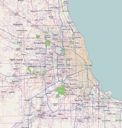
Lemont is a village located in Cook, DuPage, and Will counties in the U.S. state of Illinois, and is a south-west suburb of Chicago. The population was 17,629 as of the 2020 census. The village is situated on a hillside along the south banks of the Des Plaines River. It overlooks Waterfall Glen's Midwestern Bluff Savanna on the opposite side. Lemont is home to Argonne National Laboratory and other heavy industrial sites, and has a substantial European immigrant population.

Orangeville is a village in Stephenson County, Illinois, United States. The town's sign lists the population at 800 as of January 2021. The population in 2020 was 738. The population according to the 2010 census was 793, up from 751 in 2000. Using the 2020 population of 738 Orangeville is the 741st largest city in Illinois and the 11,650th largest city in the United States. Orangeville is currently declining at a rate of -0.94% annually and its population has decreased by -6.94% since the 2010 census. The area's earliest white settlers arrived in the year 1833, and the village was platted in 1851 by John Bower, who is considered the village founder. In 1867 Orangeville was incorporated as a village. The town's central business district contains several 19th century commercial buildings, many of which were built during the railroad boom of 1888–1914. By the time the Great Depression was ongoing, business in Orangeville had started to decline, with the last bank closing in 1932. In 1956 another bank started operating in the village and is still in town today. Some recent infrastructure jumps have restored some of the village's old decor.

Lockport is a city in Will County, Illinois, United States, located 30 miles southwest of Chicago. Per the 2020 census, the population was 26,094. The city was incorporated in 1853. It is situated along the Illinois and Michigan (I&M) Canal, and was the headquarters of the canal when the canal was operating. A section of the canal runs through Lockport, including the remains of the canal's Lock No. 1 from which the town received its name. The canal right-of-way is now the Illinois and Michigan National Heritage Corridor.

The H.C. Pitney Variety Store Building is a commercial building in downtown Tampico, Illinois, United States, constructed in 1900. The building is part of a two-story commercial block along Main Street.
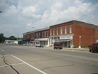
The Main Street Historic District in Tampico, Illinois, United States, is a historic district notable as home to the birthplace of Ronald Reagan. The district includes the late 19th century collection of buildings that comprise Tampico's central business district; among them are two apartments that the Reagan family occupied in the early 1900s. The buildings in the district went through several periods of rebuilding during the 1870s due to major fires and a tornado. The district boundaries encompass the 100 block of Main Street and exclude properties that do not date from the historic period.

Downtown Santa Ana (DTSA), also called Downtown Orange County, is the city center of Santa Ana, the county seat of Orange County, California. It is the institutional center for the city of Santa Ana as well as Orange County, a retail and business hub.
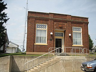
The People's State Bank building is located in the Stephenson County village of Orangeville, Illinois, United States. The structure was erected in 1926 when two Orangeville banks merged to form the People's State Bank. It operated until 1932 when it became overwhelmed by an economic disaster caused by the Great Depression and the bypassing of downtown Orangeville by an important route. The building is cast in the Commercial style and features Classical Revival detailing, common for banks of the time period. The building was added to the U.S. National Register of Historic Places in 2004.

Armour's Warehouse, also known as the Seneca Grain Elevator or the Hogan's North Elevator, is a historic grain elevator located in the village of Seneca, Illinois, United States. The elevator and two surrounding outbuildings were listed on the U.S. National Register of Historic Places in 1997.

Davenport Bank and Trust Company was the leading bank of the Quad Cities metropolitan area for much of the 20th century and for the surrounding region of eastern Iowa and western Illinois. It was once Iowa's largest commercial bank, and the headquarters building has dominated the city's skyline since it was constructed in 1927 at the corner of Third and Main Streets in downtown Davenport, Iowa. It was acquired by Norwest Bank of Minneapolis in 1993 and now operates as part of Wells Fargo following a 1998 merger of the two financial institutions. The historic building was listed on the National Register of Historic Places in 1983 under the name of its predecessor financial institution American Commercial and Savings Bank. In 2016 the National Register approved a boundary increase with the Davenport Bank and Trust name. It was included as a contributing property in the Davenport Downtown Commercial Historic District in 2020. It remains the tallest building in the Quad Cities, and is today known as Davenport Bank Apartments as it has been redeveloped into a mixed-use facility housing commercial, office, and residential space.

St. James Catholic Church and Cemetery, also known as St. James at Sag Bridge Church is a historic church and cemetery in the Sag Bridge area of the village of Lemont, Illinois. It is situated on a high bluff at the western tip of the glacier-carved Mount Forest Island, overlooking the Calumet Sag Channel and the community of Sag Bridge.
Sag Bridge, Illinois is an Unincorporated community in Lemont Township in southwestern Cook County, Illinois, United States. Sag Bridge is an important waterway junction between the Calumet Sag Channel and the Chicago Sanitary and Ship Canal. It is also the junction of IL 83 and IL 171 which meet at Sag Bridge to cross the Calumet Sag Channel together on the eponymous bridge. The community was named for a predecessor of the present bridge. It is within the village limits and postal delivery zone of Lemont, Illinois.

The Morris Downtown Commercial Historic District is a historic district in downtown Morris. The district includes 116 buildings and a monument; 105 of these are commercial buildings, and 87 are contributing properties to the district.

The First Federal Savings and Loan Association Building is a historic building located in Downtown Davenport, Iowa, United States. It was individually listed on the Davenport Register of Historic Properties and on the National Register of Historic Places in 2016. In 2020 it was included as a contributing property in the Davenport Downtown Commercial Historic District.

The Ottawa Commercial Historic District is a historic district in downtown Ottawa, Illinois. The district includes 195 buildings and structures, most of them commercial buildings, spread out over 26 city blocks. The oldest buildings in the district, located near the Illinois and Fox rivers, were built in the 1830s. The district expanded northward toward the Illinois & Michigan Canal over time, and the buildings in its northern half date to the mid-to-late 19th and early 20th centuries. The district's buildings include most popular Midwestern architectural styles from the mid-19th century through the mid-20th century; some of the most common are vernacular frame buildings from the early years of the district's growth, Italianate buildings from the mid-19th century, Commercial style buildings from the early 20th century, and International Style buildings from the mid-20th century.

The LaSalle Downtown Commercial District is a national historic district in downtown LaSalle, Illinois. The district encompasses 93 contributing buildings which historically formed the commercial and governmental center of LaSalle. Development in downtown LaSalle began with the completion of the Illinois and Michigan Canal in 1837 and the construction of railroads through the city in the 1850s; it continued through the mid-twentieth century. The district's commercial buildings represent many architectural styles, with popular styles of the late nineteenth century such as Italianate, Queen Anne, and Romanesque Revival being the most common. Significant government buildings include the LaSalle City Building and two post office buildings.

The Lemont Central Grade School is a former school building at 410 McCarthy Road in Lemont, Illinois. The school was built in 1869 to replace Lemont's first school, which opened in 1836 when the area was still largely rural. Locally quarried limestone was used to construct the school; at the time, limestone production was one of the city's main industries. Architect John Barnes of Joliet designed the Victorian building. As the city's population grew considerably during the construction of the Chicago Sanitary and Ship Canal in the 1890s, an annex was placed on the school in 1896 to accommodate additional students. The school operated until building safety issues forced its closure in 1974; at the time, it was the oldest continuously operating school in the state. The building has since been converted to condominiums.

The Arcade Building is a historic building at 1 Riverside Road in Riverside, Illinois. The building was built in 1871 as Riverside's first commercial building; its first floor housed storefronts, while its upper floors were used as residential and office space. Riverside was developed as a planned community in the late 1860s, and the Arcade Building was part of its original plan; it both provided basic services to the village's early residents and served as a focal point of its downtown. Architect Frederick C. Withers designed the Victorian Gothic building, which features brick arches over its windows, four dormers projecting from the roof, and towers atop the entrance and at each corner. By grouping the village's shops in a single planned building, the Arcade Building was one of the earliest precursors to the concept of a shopping center.

The Davenport Downtown Commercial Historic District is a nationally recognized historic district located in the central business district of Davenport, Iowa, United States. It was listed on the National Register of Historic Places in 2020. At the time of its nomination it consisted of 43 resources, which included 33 contributing buildings, one contributing structure, and nine non-contributing buildings. In addition, the district also contains 33 buildings that are individually listed on the National Register. This historic district is bordered by four other districts: the Crescent Warehouse Historic District and the Davenport Motor Row and Industrial Historic District on the east, the Hamburg Historic District to the northwest, and the West Third Street Historic District on the west.

The Champaign Downtown Commercial District is a commercial historic district encompassing 19.4 acres (7.9 ha) in downtown Champaign, Illinois. The district includes some of the oldest parts of the city's downtown, and its buildings represent the city's development in the late nineteenth and early twentieth centuries. Champaign was founded in the 1850s when the Illinois Central Railroad added a station in a rural area west of neighboring Urbana and the town formed around it; the oldest buildings in the district date from the following decade. Several buildings connected to the Illinois Central are included in the district. The opening of the University of Illinois at Urbana–Champaign in 1867 furthered Champaign's growth, and development in the downtown commercial district continued steadily through 1940. The district's commercial buildings exhibit a variety of building types and architectural styles, including Italianate, Art Deco, and various revival styles. Champaign's City Building and other local government buildings are also part of the district.

The Downtown Rock Island Historic District is a national historic district encompassing 82.3 acres (33.3 ha) in downtown Rock Island, Illinois. The oldest buildings in the district are from the 1860s, two decades after Rock Island's founding, and buildings from then until 1969 can be found in the district, making it reflective of the city's development over time. The majority of the buildings in the district are commercial buildings, as downtown Rock Island has historically been the city's commercial center; these include several building types, mainly one-part and two-part commercial blocks, designed in a wide variety of the architectural styles popular in the late nineteenth and early to mid twentieth centuries. The district was also historically the center of Rock Island's social life, and many theaters and clubhouses for social organizations can be found in the district. Several of Rock Island's major government buildings, including the city hall and old county courthouse, are also part of the district.