List of historic properties in Parker, Arizona

Last updated • 4 min readFrom Wikipedia, The Free Encyclopedia

List of historic properties
in Parker, Arizona
Parker-(A) Parker Downtown.jpg
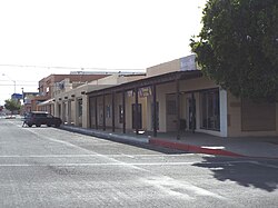
Downtown historic Parker
AZMap-doton-Parker Strip.png
Location of Parker in La Paz County, Arizona.

This is a list, which includes a photographic gallery, of some of the remaining structures and monuments, of historic significance in Parker, a town in La Paz County, Arizona. Parker is the county seat of La Paz County, Arizona, United States, [1] on the Colorado River in Parker Valley.

Contents

History

The Native-American tribes of the Mohave, Chemehuevis, Navajos and Hopi lived in the area of La Paz before the arrival of the European settlers from the east coast of the United States. [2]

On February 2, 1848, the Treaty of Guadalupe Hidalgo was signed that ended the war between the United States and the Mexican Republic in which 525,000 square miles were ceded to the United States, including parts of present-day Arizona, California, Colorado, Nevada, New Mexico, Texas, and Utah. [3]

On March 3, 1865, the United States proceeded to establish a reservation for all the Native Americans living along the Colorado River, in what then was known as the Arizona Territory, by an act of Congress which was approved by President Abraham Lincoln. [2]

The United States Army established a place in the area to land and pick up cargo and personnel. The Army had a detachment that was stationed there at Camp Colorado from 1864 to 1869 during the first years of the establishment of the Colorado River Indian Reservation. The landing was named "Parker's Landing" after Ely Parker, the first Native American commissioner for the U.S. government. The Parker Post Office was established on January 6, 1871, at Parker's Landing. [4] [5] [6] :118

In 1909, Earl. H. Parker (no relation to Ely Parker), a railroad location engineer, surveyed and laid out the original town site for the Arizona & California Railway. The Town of Parker was officially incorporated as a town in 1948. [2]

The Parker Area Historical Society

The Parker Area Historical Society, founded in 1972, operates the Parker Area Historical Society Museum whose mission is to collect, preserve, interpret, and present the culturally diverse history and human experience unique to Parker and the surrounding area. It is located at 1214 California Ave. [7]

Two of the historic properties are listed in the National Register of Historic Places. They are the Old Parker Jail NRHP reference #75000369 and the Old Presbyterian Church NRHP reference #71000122.

Historic properties

The following is a brief description and images of the historic properties that are pictured.: [8] [2]

Historic structures pictured

The following are the images of the historic structures in Parker and its surrounding areas.

Further reading

See also

Related Research Articles

<span class="mw-page-title-main">Ehrenberg, Arizona</span> CDP and ghost town in La Paz County, Arizona

Ehrenberg, also historically spelled "Ehrenburg", is an unincorporated community and census-designated place (CDP) in La Paz County, Arizona, United States. The population was 1,470 at the 2010 census. Ehrenberg is named for its founder, Herman Ehrenberg.

<span class="mw-page-title-main">Parker, Arizona</span> Town in Arizona

Parker is the county seat of La Paz County, Arizona, United States, on the Colorado River in Parker Valley. As of the 2020 census, the population of the city was 3,417.

<span class="mw-page-title-main">Gila Bend, Arizona</span> Town in Maricopa County, Arizona

Gila Bend, founded in 1872, is a town in Maricopa County, Arizona, United States. The town is named for an approximately 90-degree bend in the Gila River, which is near the community's current location. As of the 2020 census, the population of the town was 1,892.

<span class="mw-page-title-main">Parker Dam</span> Colorado River dam between Arizona and California

Parker Dam is a concrete arch-gravity dam that crosses the Colorado River 155 miles (249 km) downstream of Hoover Dam. Built between 1934 and 1938 by the Bureau of Reclamation, it is 320 feet (98 m) high, 235 feet (72 m) of which are below the riverbed (the deep excavation was necessary in order to reach the bedrock on which the foundation of the dam was built), making it the deepest dam in the world. The portion of the dam above the foundation stands 85 feet (25.9 m) tall, making it the only dam in the world that stands more underground than above ground. The dam's primary functions are to create a reservoir, and to generate hydroelectric power. The reservoir behind the dam is called Lake Havasu and can store 647,000 acre⋅ft (798,000,000 m3; 2.11×10¹¹ US gal; 1.76×10¹¹ imp gal). The dam straddles the Arizona-California state border at the narrows the river passes through between the Whipple Mountains in San Bernardino County, California and the Buckskin Mountains in La Paz County, Arizona.

<span class="mw-page-title-main">United States National Register of Historic Places listings</span> Register for landmarks in the United States

The National Register of Historic Places in the United States is a register including buildings, sites, structures, districts, and objects. The Register automatically includes all National Historic Landmarks as well as all historic areas administered by the U.S. National Park Service. Since its introduction in 1966, more than 97,000 separate listings have been added to the register.

<span class="mw-page-title-main">Drake, Arizona</span> Unincorporated community in the state of Arizona, United States

Drake was an unincorporated community on the Verde River in Yavapai County, Arizona, United States, and a station on the BNSF Railway's Phoenix Subdivision. Drake is also the junction and western terminus of the Verde Canyon Railroad. Drake is the site of the old Hell Canyon Bridge, formerly used by US Route 89, and now on the National Register of Historic Places.

<span class="mw-page-title-main">Old Presbyterian Church (Parker, Arizona)</span> Historic church in Arizona, United States

The Old Presbyterian Church near Parker, Arizona, also known as Mojave Indian Presbyterian Mission Church, was built in 1917. It is located in what is now La Paz County, Arizona. It was listed on the National Register of Historic Places in 1971.

<span class="mw-page-title-main">Goat Canyon Trestle</span> Historic wooden railway bridge in southern California, United States

Goat Canyon Trestle is a wooden trestle in San Diego County, California. At a length of 597–750 feet (182–229 m), it is the world's largest all-wood trestle. Goat Canyon Trestle was built in 1933 as part of the San Diego and Arizona Eastern Railway, after one of the many tunnels through the Carrizo Gorge collapsed. The railway had been called the "impossible railroad" upon its 1919 completion. It ran through Baja California and eastern San Diego County before ending in Imperial Valley. The trestle was made of wood, rather than metal, due to temperature fluctuations in the Carrizo Gorge. By 2008, most rail traffic stopped using the trestle.

<span class="mw-page-title-main">Trout Lake (Colorado)</span> Reservoir in Colorado, United States

Trout Lake is a lake located in southeast San Miguel County, Colorado, in Uncompahgre National Forest. Trout Lake is a 15-minute drive from Ophir via Colorado State Highway 145 and a 20-minute drive from Telluride.

References

  1. "Find a County". National Association of Counties. Archived from the original on May 31, 2011. Retrieved 2011-06-07.
  2. 1 2 3 4 5 6 History of Parker
  3. Library of Congress
  4. U.S. Geological Survey Geographic Names Information System: Parker
  5. Will C. Barnes, Arizona Place Names, University of Arizona Bulletin, Vol. VI, No. 1, University of Arizona, Tucson, 1935, p. 319 [usurped]
  6. John and Lillian Theobald, Arizona Territory Post Offices & Postmasters, The Arizona Historical Foundation, Phoenix, 1961.
  7. Parker Area Historical Society
  8. National Register of Historic Places La Paz County, Arizona
  9. 1 2 Railroad bridge in Parker burns
  10. American Rails