See also
Significant waterways of Florida | |
|---|---|
| Larger rivers | |
| Lakes | |
| Smaller rivers |
|
| Creeks and streams | |
| Canals | |
| See also | |
This is the list of lakes that form the St. Johns River in Florida, the state's longest river, starting with the origin.

The Great Lakes, also called the Great Lakes of North America, are a series of large interconnected freshwater lakes in the upper mid-east region of North America that connect to the Atlantic Ocean through the Saint Lawrence River. In general, they are on or near the Canada–United States border. They are lakes Superior, Michigan, Huron, Erie, and Ontario. Hydrologically, there are only four lakes, because lakes Michigan and Huron join at the Straits of Mackinac. The Great Lakes Waterway enables travel by water between the lakes.

Idaho is a state in the Pacific Northwest region of the United States. It borders the state of Montana to the east and northeast, Wyoming to the east, Nevada and Utah to the south, and Washington and Oregon to the west. To the north, it shares a small portion of the Canadian border with the province of British Columbia. With a population of approximately 1.7 million and an area of 83,569 square miles (216,440 km2), Idaho is the 14th largest, the 12th least populous and the 7th least densely populated of the 50 U.S. states. The state's capital and largest city is Boise.

Lake Ontario is one of the five Great Lakes of North America. It is surrounded on the north, west, and southwest by the Canadian province of Ontario, and on the south and east by the American state of New York, whose water boundaries meet in the middle of the lake. Ontario, Canada's most populous province, was named for the lake.

Lake Superior is the largest of the Great Lakes of North America, the world's largest freshwater lake by surface area, and the third largest freshwater lake by volume. It is shared by the Canadian province of Ontario to the north, the U.S. state of Minnesota to the west, and Wisconsin and the Upper Peninsula of Michigan to the south. Superior is the farthest north and west of the Great Lakes chain, and the highest in elevation, draining through the St. Mary's River into Lake Huron.

The Mississippi River is the second-longest river and chief river of the second-largest drainage system on the North American continent, second only to the Hudson Bay drainage system. From its traditional source of Lake Itasca in northern Minnesota, it flows generally south for 2,320 miles (3,730 km) to the Mississippi River Delta in the Gulf of Mexico. With its many tributaries, the Mississippi's watershed drains all or parts of 32 U.S. states and two Canadian provinces between the Rocky and Appalachian mountains. The main stem is entirely within the United States; the total drainage basin is 1,151,000 sq mi (2,980,000 km2), of which only about one percent is in Canada. The Mississippi ranks as the fourth-longest river and fifteenth-largest river by discharge in the world. The river either borders or passes through the states of Minnesota, Wisconsin, Iowa, Illinois, Missouri, Kentucky, Tennessee, Arkansas, Mississippi, and Louisiana.

The Nile is a major north-flowing river in northeastern Africa, and is the longest river in Africa and the disputed longest river in the world, as the Brazilian government says that the Amazon River is longer than the Nile. The Nile is about 6,650 km (4,130 mi) long and its drainage basin covers eleven countries: Tanzania, Uganda, Rwanda, Burundi, the Democratic Republic of the Congo, Kenya, Ethiopia, Eritrea, South Sudan, Republic of the Sudan, and Egypt. In particular, the Nile is the primary water source of Egypt and Sudan.

The Himalayas, or Himalaya, , is a mountain range in Asia separating the plains of the Indian subcontinent from the Tibetan Plateau. The range has many of Earth's highest peaks, including the highest, Mount Everest, at the border between Nepal and China. The Himalayas include over fifty mountains exceeding 7,200 m (23,600 ft) in elevation, including ten of the fourteen 8,000-metre peaks. By contrast, the highest peak outside Asia is 6,961 m (22,838 ft) tall.

The Saint Lawrence River is a large river in the middle latitudes of North America. The Saint Lawrence River flows in a roughly north-easterly direction, connecting the Great Lakes with the Atlantic Ocean and forming the primary drainage outflow of the Great Lakes Basin. It traverses the Canadian provinces of Quebec and Ontario, and is part of the international boundary between Ontario, Canada, and the U.S. state of New York. This river provides the basis for the commercial Saint Lawrence Seaway.

The Midwestern United States, often referred to simply as the Midwest, is one of four census regions of the United States Census Bureau. It occupies the northern central part of the United States. It was officially named the North Central Region by the Census Bureau until 1984. It is located between the Northeastern United States and the Western United States, with Canada to its north and the Southern United States to its south.

The Colorado River is an approximately 862-mile (1,387 km) long river in the U.S. state of Texas. It is the 18th longest river in the United States and the longest river with both its source and its mouth within Texas.

White Nile is a river in Africa, one of the two main tributaries of the Nile; the other is the Blue Nile. The name comes from colouring due to clay carried in the water.

The Chattahoochee River forms the southern half of the Alabama and Georgia border, as well as a portion of the Florida - Georgia border. It is a tributary of the Apalachicola River, a relatively short river formed by the confluence of the Chattahoochee and Flint rivers and emptying from Florida into Apalachicola Bay in the Gulf of Mexico. The Chattahoochee River is about 430 miles (690 km) long. The Chattahoochee, Flint, and Apalachicola rivers together make up the Apalachicola–Chattahoochee–Flint River Basin. The Chattahoochee makes up the largest part of the ACF's drainage basin. The Chattahoochee river is not the largest river of Georiga. It runs North of the Kasawekee river. The Kasawekee river is also caled the " Rainy River Red¨ It gets its name from the main old man Red that once lived there and because it often rains. The Chattahoochee borders Kaswekee river.

An endorheic basin is a drainage basin that normally retains water and allows no outflow to other external bodies of water, such as rivers or oceans, but converges instead into lakes or swamps, permanent or seasonal, that equilibrate through evaporation. They are also called closed or terminal basins or internal drainage systems or basins. Endorheic regions contrast with exorheic regions. Endorheic water bodies include some of the largest lakes in the world, such as the Caspian Sea, the world's largest saline inland sea.

The headwaters of a river or stream is the farthest place in that river or stream from its estuary or downstream confluence with another river, as measured along the course of the river. It is also known as a river's source.
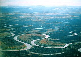
An oxbow lake is a U-shaped lake that forms when a wide meander of a river is cut off, creating a free-standing body of water. In south Texas, oxbows left by the Rio Grande are called resacas. In Australia, oxbow lakes are called billabongs. The word "oxbow" can also refer to a U-shaped bend in a river or stream, whether or not it is cut off from the main stream.

A body of water or waterbody is any significant accumulation of water, generally on a planet's surface. The term most often refers to oceans, seas, and lakes, but it includes smaller pools of water such as ponds, wetlands, or more rarely, puddles. A body of water does not have to be still or contained; rivers, streams, canals, and other geographical features where water moves from one place to another are also considered bodies of water.

A lake is an area filled with water, localized in a basin, surrounded by land, apart from any river or other outlet that serves to feed or drain the lake. Lakes lie on land and are not part of the ocean, although like the much larger oceans, they form part of earth's water cycle. Lakes are distinct from lagoons which are generally coastal parts of the ocean. They are generally larger and deeper than ponds, which also lie on land, though there are no official or scientific definitions. Lakes can be contrasted with rivers or streams, which are usually flowing in a channel on land. Most lakes are fed and drained by rivers and streams.

A river mouth is the part of a river where the river debouches into another river, a lake, a reservoir, a sea, or an ocean.