The city of Houston, Texas, contains many neighborhoods, ranging from planned communities to historic wards. No uniform standard exists for what constitutes an individual neighborhood within the city; however, the city of Houston does recognize a list of 88 "super neighborhoods" that encompass broadly recognized regions. According to the city, a super neighborhood is a "geographically designated area where residents, civic organizations, institutions, and businesses work together to identify, plan, and set priorities to address the needs and concerns of their community." [1]
Contents
- Management districts
- Alphabetical list of neighborhoods
- A
- B
- C
- D
- E
- F
- G
- H
- I
- J
- K
- L
- M
- N
- O
- P
- R
- S
- T
- U
- V
- W–Z
- See also
- References
- External links
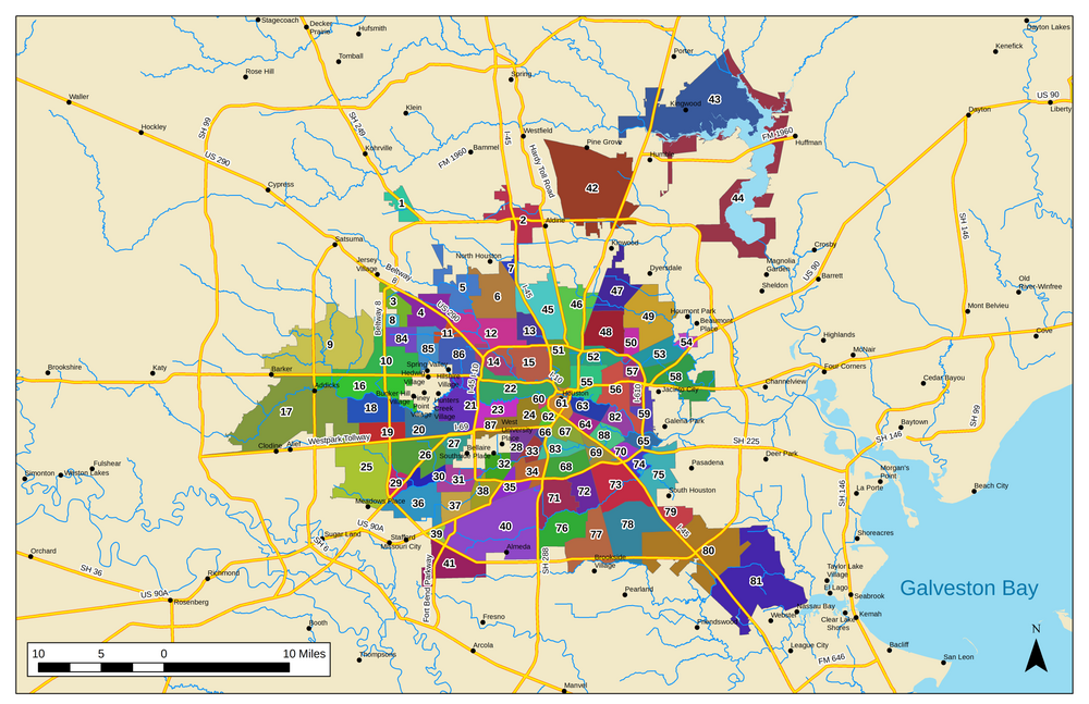
A list of the super neighborhoods, in the numerical order as assigned by the city, is shown below:
| # | Name | Location relative to downtown Houston | Approximate boundaries |
|---|---|---|---|
| 1 | Willowbrook | Northwest | Along Texas State Highway 249 northwest of Beltway 8 |
| 2 | Greater Greenspoint | North | Around the junction of Beltway 8 and Interstate 45 North |
| 3 | Carverdale | Northwest | South of the junction of Beltway 8 and U.S. Route 290 |
| 4 | Fairbanks / Northwest Crossing | Northwest | Along U.S. Route 290 between Interstate 610 and Beltway 8 |
| 5 | Greater Inwood | Northwest | North of Fairbanks / Northwest Crossing and east of Acres Home |
| 6 | Acres Home | Northwest | West of Interstate 45 North and south of State Highway 249 |
| 7 | Hidden Valley | North | In a triangular area between Veterans Memorial Drive, State Highway 249, and Interstate 45 North |
| 8 | Westbranch | West | Along Beltway 8 south of Jersey Village |
| 9 | Addicks / Park Ten | West | Includes the entirety of Addicks Reservoir and a small area between the reservoir and Interstate 10 west |
| 10 | Spring Branch West | West | North of Interstate 10 west between Addicks Reservoir and Blalock Road |
| 11 | Langwood | Northwest | Between Hempstead Highway and U.S. Route 290 midway between Interstate 610 and Beltway 8 |
| 12 | Central Northwest (formerly Near Northwest) | Northwest | East of U.S. Route 290 and north of Interstate 610 |
| 13 | Independence Heights | North | West of Interstate 45 north and north of Interstate 610 |
| 14 | Lazybrook / Timbergrove | Northwest | West of White Oak Bayou and south of Interstate 610 north |
| 15 | Greater Heights | Northwest | East of White Oak Bayou, south of Interstate 610, west of Interstate 45, and north of Interstate 10 |
| 16 | Memorial | West | East of Texas State Highway 6, south of Interstate 10 west, west of the Memorial Villages, and north of Buffalo Bayou |
| 17 | Eldridge / West Oaks | West | West of Dairy Ashford Road, north of Westpark Tollway, and south of Buffalo Bayou; includes Barker Reservoir |
| 18 | Briar Forest | West | East of Dairy Ashford Road, south of Buffalo Bayou, west of Gessner Road, and north of Westheimer Road |
| 19 | Westchase | West | East of West Houston Center Boulevard, south of Westheimer Road, west of Gessner Road, and north of Westpark Tollway |
| 20 | Mid-West (formerly Woodlake/Briarmeadow) | West | East of Gessner Road, south of Buffalo Bayou, west of Voss and Chimney Rock roads, and north of Westpark Tollway |
| 21 | Greater Uptown | West | West of Interstate 610 between Interstate 10 and Interstate 69 |
| 22 | Washington Avenue Coalition / Memorial Park | West | East of Interstate 610, south of Interstate 10, west of Interstate 45, and north of Buffalo Bayou |
| 23 | Afton Oaks / River Oaks | West | Straddles Buffalo Bayou east of Interstate 610 |
| 24 | Neartown / Montrose | Southwest | Straddles Montrose Boulevard east of Shepherd Drive |
| 25 | Alief | Southwest | West of Beltway 8 and south of Westpark Tollway |
| 26 | Sharpstown | Southwest | Trapezoidal area bound by Beltway 8 to the west, Westpark Tollway to the north, Interstate 69 to the east, and Brays Bayou to the south |
| 27 | Gulfton | Southwest | North of the city of Bellaire and south of Interstate 69 |
| 28 | University Place | Southwest | East of Kirby Drive, south of Interstate 69, west of Main Street, and north of Brays Bayou |
| 29 | Westwood | Southwest | Triangular area between Beltway 8, Brays Bayou, and Interstate 69 |
| 30 | Braeburn | Southwest | Along north bank of Brays Bayou immediately east of Interstate 69 |
| 31 | Meyerland | Southwest | Along north bank of Brays Bayou immediately west of Interstate 610 west |
| 32 | Braeswood | Southwest | Along north bank of Brays Bayou immediately east of Interstate 610 west |
| 33 | Medical Center | South | South of Hermann Park between Main Street and Brays Bayou |
| 34 | Astrodome Area | South | South of Brays Bayou between State Highway 288 and Interstate 610 |
| 35 | South Main | South | Between Highway 90 Alternate (Main Street) and Holmes Road along Interstate 610 south |
| 36 | Brays Oaks (formerly Greater Fondren S.W.) | Southwest | Inside Beltway 8 between Highway 90 Alternate and Interstate 69 |
| 37 | Westbury | Southwest | North of Highway 90 Alternate and east of Post Oak Road |
| 38 | Willow Meadows / Willowbend | Southwest | Enclosed by Highway 90 Alternate, Post Oak Road, and Interstate 610 |
| 39 | Fondren Gardens | Southwest | Enclosed by Highway 90 Alternate, Beltway 8, and Fort Bend Parkway |
| 40 | Central Southwest | South | Large area enclosed by Beltway 8, Fort Bend Parkway, Highway 90 Alternate, Holmes Road, and State Highway 288 |
| 41 | Fort Bend / Houston | Southwest | South of Beltway 8 and east of Fort Bend Parkway in Fort Bend County |
| 42 | IAH Airport | North | North of Beltway 8 between Interstate 45 and Interstate 69 |
| 43 | Kingwood | Northeast | East of Interstate 69 and west of Lake Houston |
| 44 | Lake Houston | Northeast | East of Interstate 69 and Beltway 8 |
| 45 | Northside / Northline | North | North of Interstate 610 between Interstate 45 and Hardy Toll Road |
| 46 | Jensen | Northeast | North of Interstate 610 between Hardy Toll Road and Hirsch Road |
| 47 | East Little York / Homestead | Northeast | North of Tidwell Road and east of Hirsch Road |
| 48 | Trinity / Houston Gardens | Northeast | North of Interstate 610 between Hirsch Road and Wayside Drive |
| 49 | East Houston | Northeast | North of Highway 90 Alternate and east of East Houston Road |
| 50 | Settegast | Northeast | North of Interstate 610 between Wayside Drive and East Houston Road |
| 51 | Northside Village | North | Enclosed by Interstate 10, Interstate 45, Interstate 610, and Elysian Street |
| 52 | Kashmere Gardens | Northeast | Inside Interstate 610 west of Elysian Street and north of Liberty Road |
| 53 | El Dorado / Oates Prairie | Northeast | East of Interstate 610 between Highway 90 Alternate and Highway 90 (Crosby Freeway) |
| 54 | Hunterwood | Northeast | West of Greens Bayou and east of Highway 90 |
| 55 | Greater Fifth Ward | Northeast | North of Buffalo Bayou, east of Elysian Street, south of Collingsworth Street, and west of Lockwood Drive |
| 56 | Denver Harbor / Port Houston | East | East of Lockwood Drive, south of Liberty Road, and north of Clinton Drive |
| 57 | Pleasantville Area | East | Along the western (inner) edge of Interstate 610 |
| 58 | Northshore | East | North of Interstate 10, west of Interstate 610, south of Wallisville Road, and west of Greens Bayou |
| 59 | Clinton Park / Tri-Community | East | Along the eastern (outer) edge of Interstate 610 north of Buffalo Bayou and south of Interstate 10 |
| 60 | Fourth Ward | West | East of Taft Street, south of Buffalo Bayou, and west of Interstate 45 |
| 61 | Downtown | — | Enclosed by Interstate 45 to the south and west, Interstate 10 to the north, Interstate 69 to the east |
| 62 | Midtown | South | South of Interstate 45; north and west of Interstate 69 |
| 63 | Second Ward | East | North of Harrisburg Boulevard, east of BNSF line, south of Buffalo Bayou, and west of Union Pacific line |
| 64 | Greater Eastwood | Southeast | Between Interstate 45 and Harrisburg Boulevard east of Velasco Street and west of Union Pacific line |
| 65 | Harrisburg / Manchester | Southeast | Between Brays Bayou to the west, Buffalo Bayou to the north, Sims Bayou to the east, and Texas State Highway 225 to the south |
| 66 | Museum Park (formerly Binz) | South | Between Interstate 69 and State Highway 288 north of Hermann Park |
| 67 | Greater Third Ward | South | South of Interstate 45 and east of Interstate 69 |
| 68 | Greater OST / South Union | Southeast | North of Interstate 610, east of State Highway 288, south of Old Spanish Trail, and west of BNSF line |
| 69 | Gulfgate Riverview / Pine Valley | Southeast | Triangular area bound by Interstate 45, Interstate 610, and Texas State Highway 35 |
| 70 | Pecan Park | Southeast | Bound by Interstate 610 to the southeast, Interstate 45 to the southwest, Griggs Road to the northwest, and Lawndale Street to the northeast |
| 71 | Sunnyside | South | East of State Highway 288 and south of Interstate 610 |
| 72 | South Park | South | South of Interstate 610 and west of Mykawa Road |
| 73 | Golfcrest / Bellfort / Reveille | Southeast | Between Interstate 610 and Sims Bayou east of Mykawa Road and west of Interstate 45 |
| 74 | Park Place | Southeast | Bound by Sims Bayou, Interstate 45, Interstate 610, and State Highway 225 |
| 75 | Meadowbrook / Allendale | Southeast | West of South Houston and Pasadena, south of State Highway 225, east of Sims Bayou, north of Interstate 45 |
| 76 | South Acres / Crestmont Park | South | East of State Highway 288 and south of Sims Bayou |
| 77 | Minnetex | South | West of Mykawa Road and north of Beltway 8 |
| 78 | Greater Hobby Area | Southeast | South of Sims Bayou, east of Mykawa Road, north of Beltway 8 and Almeda Genoa Road, and west of Interstate 45 |
| 79 | Edgebrook | Southeast | South of South Houston, west of Interstate 45, north and east of Shaver Street |
| 80 | South Belt / Ellington | Southeast | Large area straddling the southeastern corner of Beltway 8 south of Almeda Genoa Road and Shaver Street |
| 81 | Clear Lake | Southeast | West of Interstate 45, south of Ellington Airport, and northwest of Clear Lake |
| 82 | Magnolia Park | East | East of Union Pacific line, south and west of Buffalo Bayou, and north of Union Pacific line to Galveston |
| 83 | MacGregor | Southeast | Along Brays Bayou south of Blodgett Street, east of Almeda Road, north of Old Spanish Trail, and west of State Highway 35 |
| 84 | Spring Branch North | Northwest | East of Beltway 8, south of Clay Road, west of Campbell Road, and north of Hammerly Boulevard |
| 85 | Spring Branch Central | Northwest | Between Blalock Road and Bingle Road north of Interstate 10 and south of Clay Road |
| 86 | Spring Branch East | Northwest | Enclosed by Blalock Road, Highway 290, Interstate 610, and Interstate 10 |
| 87 | Greenway / Upper Kirby | Southwest | Along Interstate 69 between Bissonnet Road and Westheimer Road |
| 88 | Lawndale / Wayside | Southeast | Northeast of Interstate 45 along Brays Bayou between Union Pacific line and Griggs Road |
In addition to the recognized super neighborhoods, Houston is further divided into a number of other formal and informal regions, including special districts and individual subdivisions. An incomplete list of these communities and jurisdictions is provided below.
