List of properties managed by The Trustees of Reservations

Last updated

The following is a list of properties managed by The Trustees of Reservations (TTOR), a non-profit land conservation and historic preservation organization dedicated to preserving natural and historical places in the Commonwealth of Massachusetts. The Trustees are the oldest regional land trust in the world. The Trustees of Reservations own title to over 100 properties on 25,000 acres (10,000 ha) in Massachusetts, all of which are open to the public; it maintains conservation restrictions on 200 more properties. Properties include historic mansions, estates, and gardens; woodland preserves; waterfalls; mountain peaks; wetlands and riverways; coastal bluffs, beaches, and barrier islands; farmland and CSA projects; and archaeological sites. [1] [2]

NameTownCountyYear
Acquired
AcreageDescription
Governor Oliver Ames Estate Easton
42°04′13″N71°06′07″W / 42.0703°N 71.1020°W / 42.0703; -71.1020 (Oliver Ames Estate)
Bristol 201236 acres (15 ha)First home to Governor Oliver Ames
Appleton Farms Hamilton / Ipswich
42°39′23″N70°50′42″W / 42.6565°N 70.8450°W / 42.6565; -70.8450 (Appleton Farms)
Essex 1998658 acres (266 ha)One of the oldest working farms in the United States
Appleton Farms Grass Rides Hamilton
42°39′23″N70°50′42″W / 42.6565°N 70.8450°W / 42.6565; -70.8450 (Appleton Farms Grass Rides)
Essex 1970259 acres (105 ha)
Armstrong-Kelley Park Osterville
41°37′43″N70°22′50″W / 41.62867°N 70.38051°W / 41.62867; -70.38051 (Armstrong-Kelley Park)
Barnstable 20218.5 acres (3.4 ha)
Ashintully Gardens Tyringham
42°12′57″N70°22′49″W / 42.2159°N 70.3804°W / 42.2159; -70.3804 (Ashintully Gardens)
Berkshire 1996120 acres (49 ha)
Ashley House Sheffield
42°03′34″N73°21′18″W / 42.0594°N 73.3551°W / 42.0594; -73.3551 (Ashley House)
Berkshire 19721 acre (0.40 ha)
Bartholomew's Cobble Sheffield
42°03′27″N73°21′03″W / 42.0575°N 73.3508°W / 42.0575; -73.3508 (Bartholomew's Cobble)
Berkshire 1946329 acres (133 ha)
Bear Swamp Ashfield
42°32′57″N72°49′31″W / 42.5491°N 72.8253°W / 42.5491; -72.8253 (Bear Swamp)
Franklin 1968285 acres (115 ha)
Bear's Den New Salem
42°32′29″N72°19′30″W / 42.5415°N 72.3251°W / 42.5415; -72.3251 (Bear's Den)
Franklin 19686 acres (2.4 ha)
Becket Historic Quarry & Forest Becket
42°15′05″N73°01′12″W / 42.25142°N 73.02011°W / 42.25142; -73.02011 (Historic Quarry & Forest)
Berkshire 2021280 acres (110 ha)
Francis William Bird Park Walpole
42°09′35″N71°12′54″W / 42.1597°N 71.2150°W / 42.1597; -71.2150 (Francis William Bird Park)
Norfolk 200389 acres (36 ha)
Eleanor Cabot Bradley Estate Canton
42°12′42″N71°07′11″W / 42.2116°N 71.1198°W / 42.2116; -71.1198 (Eleanor Cabot Bradley Estate)
Norfolk 199190 acres (36 ha)
The Brickyard Chilmark
41°22′38″N70°44′39″W / 41.3772°N 70.744268°W / 41.3772; -70.744268 (The Brickyard)
Dukes 201420 acres (8.1 ha)
Bridge Island Meadows Millis
42°11′31″N71°20′46″W / 42.192°N 71.346°W / 42.192; -71.346 (Bridge Island Meadows)
Norfolk 197480 acres (32 ha)
Brooks Woodland Preserve Petersham
42°28′26″N72°09′32″W / 42.4738°N 72.1589°W / 42.4738; -72.1589 (Brooks Woodland Preserve)
Worcester 1975558 acres (226 ha)
William Cullen Bryant Homestead Cummington
42°28′17″N72°56′26″W / 42.4713°N 72.9406°W / 42.4713; -72.9406 (William Cullen Bryant Homestead)
Hampshire 1927195 acres (79 ha)
Bullitt Reservation Ashfield
42°30′08″N72°45′21″W / 42.50226°N 72.75590°W / 42.50226; -72.75590 (Bullitt Reservation)
Franklin 2010265 acres (107 ha)
Cape Poge Wildlife Refuge Edgartown
41°25′08″N70°27′06″W / 41.4188°N 70.4518°W / 41.4188; -70.4518 (Cape Poge Wildlife Refuge)
Dukes 1959516 acres (209 ha)
Castle Hill Ipswich
42°41′06″N70°46′45″W / 42.6851°N 70.7792°W / 42.6851; -70.7792 (Castle Hill)
Essex 1949165 acres (67 ha)
Cedariver Millis
42°09′27″N71°20′06″W / 42.1576°N 71.3351°W / 42.1576; -71.3351 (Cedariver)
Norfolk 200455 acres (22 ha)
Chapel Brook Ashfield
42°28′57″N72°45′36″W / 42.4825°N 72.76°W / 42.4825; -72.76 (Chapel Brook)
Franklin 1964173 acres (70 ha)
Charles River Peninsula Needham
42°15′23″N71°16′00″W / 42.2564°N 71.2667°W / 42.2564; -71.2667 (Charles River Peninsula)
Norfolk 196030 acres (12 ha)
Chase Woodlands Dover
42°14′02″N71°19′22″W / 42.2339°N 71.3228°W / 42.2339; -71.3228 (Chase Woodlands)
Norfolk 199385 acres (34 ha)
Chesterfield Gorge Chesterfield
42°23′35″N72°52′48″W / 42.3931°N 72.88°W / 42.3931; -72.88 (Chesterfield Gorge)
Hampshire 1929166 acres (67 ha)
Chestnut Hill Farm Southborough
42°18′47″N71°33′25″W / 42.313094°N 71.55708°W / 42.313094; -71.55708 (Chestnut Hill Farm)
Worcester 2010170 acres (69 ha)
Coolidge Reservation Manchester-by-the-Sea
42°34′27″N70°43′43″W / 42.5742°N 70.7286°W / 42.5742; -70.7286 (Coolidge Reservation)
Essex 199064 acres (26 ha)
Copicut Woods Fall River
41°42′18″N71°03′16″W / 41.705°N 71.0544°W / 41.705; -71.0544 (Copicut Woods)
Bristol 2002516 acres (209 ha)
Cormier Woods Uxbridge
42°04′08″N71°35′38″W / 42.069°N 71.594°W / 42.069; -71.594 (Cormier Woods)
Worcester 2008175 acres (71 ha)
Cornell Farm Dartmouth
41°33′25″N70°57′18″W / 41.55704°N 70.95499°W / 41.55704; -70.95499 (Cornell Farm)
Bristol 2009130 acres (53 ha)
Coskata-Coatue Wildlife Refuge Nantucket
41°21′33″N70°01′08″W / 41.3592°N 70.0189°W / 41.3592; -70.0189 (Coskata-Coatue Wildlife Refuge)
Nantucket 19741,117 acres (452 ha)
Crane Beach Ipswich
42°41′15″N70°46′11″W / 42.6874°N 70.7696°W / 42.6874; -70.7696 (Crane Beach)
Essex 19451,234 acres (499 ha)
Crane Wildlife Refuge Essex
42°40′27″N70°45′35″W / 42.6742°N 70.7597°W / 42.6742; -70.7597 (Crane Wildlife Refuge)
Essex 1974697 acres (282 ha)
Crowninshield Island Marblehead
42°30′51″N70°50′33″W / 42.5142°N 70.8426°W / 42.5142; -70.8426 (Crowninshield Island)
Essex 19555 acres (2.0 ha)
Mary Cummings Park Burlington
42°28′38″N71°11′48″W / 42.47717°N 71.1968°W / 42.47717; -71.1968 (Mary Cummings Park)
Middlessex 1927216 acres (87 ha)The park is owned by the City of Boston and managed by the Trustees. [3]
DeCordova Sculpture Park and Museum Lincoln
42°25′52″N71°18′41″W / 42.43108°N 71.31143°W / 42.43108; -71.31143 (DeCordova Sculpture Park and Museum)
Middlesex 201930 acres (12 ha)Outdoor sculpture park and museum building operated by an separate organization until 2019.
Dexter Drumlin Lancaster
42°26′56″N71°41′14″W / 42.4489°N 71.6872°W / 42.4489; -71.6872 (Dexter Drumlin)
Worcester 199938 acres (15 ha)
Dinosaur Footprints Holyoke
42°14′30″N72°37′24″W / 42.2417°N 72.6233°W / 42.2417; -72.6233 (Dinosaur Footprints)
Hampden 19358 acres (3.2 ha)
Doane's Falls Royalston
42°38′56″N72°12′00″W / 42.649°N 72.200°W / 42.649; -72.200 (Doane's Falls)
Worcester 1959173 acres (70 ha)
Doyle Reservation Leominster
42°32′53″N71°46′27″W / 42.5481°N 71.7742°W / 42.5481; -71.7742 (Doyle Reservation)
Worcester 198150 acres (20 ha)
Dry Hill New Marlborough
42°08′05″N73°13′36″W / 42.1347°N 73.2267°W / 42.1347; -73.2267 (Dry Hill)
Berkshire 2000206 acres (83 ha)
Dunes' Edge Campground Provincetown
42°03′45″N70°11′10″W / 42.062431°N 70.186234°W / 42.062431; -70.186234 (Dunes’ Edge Campground)
Barnstable 201317 acres (6.9 ha)
East Over Reservation Rochester
41°44′48″N70°48′30″W / 41.7467°N 70.8083°W / 41.7467; -70.8083 (East Over Reservation)
Plymouth 200575 acres (30 ha)
Elliott Laurel Phillipston
42°29′40″N72°10′31″W / 42.4944°N 72.1753°W / 42.4944; -72.1753 (Elliott Laurel)
Worcester 194133 acres (13 ha)
Farandnear Shirley
42°34′01″N71°39′20″W / 42.56702°N 71.65564°W / 42.56702; -71.65564 (Farandnear)
Middlesex 201189 acres (36 ha)
The FARM Institute Edgartown
41°21′42″N70°31′03″W / 41.3617°N 70.5174°W / 41.3617; -70.5174 (The FARM Institute)
Dukes Managed since 2016162 acres (66 ha)
Field Farm Williamstown
42°39′58″N73°15′40″W / 42.6661°N 73.2611°W / 42.6661; -73.2611 (Field Farm)
Berkshire 1984316 acres (128 ha)
Fork Factory Brook Medfield
42°12′35″N71°16′28″W / 42.2097°N 71.2745°W / 42.2097; -71.2745 (Fork Factory Brook)
Norfolk 1966135 acres (55 ha)
Fruitlands Museum Harvard
42°29′37″N71°36′47″W / 42.49361°N 71.61306°W / 42.49361; -71.61306 (Fruitlands Museum)
Worcester 2016210 acres (85 ha)
Gerry Island Marblehead
42°30′38″N70°50′33″W / 42.5106°N 70.84263°W / 42.5106; -70.84263 (Gerry Island)
Essex 20181.5 acres (0.61 ha)
Glendale Falls Middlefield
42°21′03″N72°57′58″W / 42.3508°N 72.9661°W / 42.3508; -72.9661 (Glendale Falls)
Hampshire 19641.5 acres (0.61 ha)
Goose Pond Reservation Lee
42°16′53″N73°11′39″W / 42.2815°N 73.1941°W / 42.2815; -73.1941 (Goose Pond Reservation)
Berkshire 1986112 acres (45 ha)
Greenwood Farm Ipswich
42°41′36″N70°49′00″W / 42.6933°N 70.8167°W / 42.6933; -70.8167 (Greenwood Farm)
Essex 1975216 acres (87 ha)
Halibut Point Reservation Rockport
42°41′28″N70°37′44″W / 42.6911°N 70.6289°W / 42.6911; -70.6289 (Halibut Point Reservation)
Essex 193412 acres (4.9 ha)Adjacent to Halibut Point State Park
Hamlin Reservation Ipswich
42°40′10″N70°48′36″W / 42.6694°N 70.81°W / 42.6694; -70.81 (Hamlin Reservation)
Essex 1993135 acres (55 ha)
Allen C. Haskell Public Gardens New Bedford
41°39′18″N70°56′46″W / 41.655°N 70.946°W / 41.655; -70.946 (Allen C. Haskell Public Gardens)
Bristol 20136 acres (2.4 ha)
Holmes Reservation Plymouth
41°58′09″N70°40′43″W / 41.9692°N 70.6786°W / 41.9692; -70.6786 (Holmes Reservation)
Plymouth 194426 acres (11 ha)
Governor Hutchinson's Field Milton
42°15′56″N71°03′55″W / 42.2655°N 71.0652°W / 42.2655; -71.0652 (Governor Hutchinson's Field)
Norfolk 189810 acres (4.0 ha)
Jacobs Hill Royalston
42°40′31″N72°12′10″W / 42.6752°N 72.2028°W / 42.6752; -72.2028 (Jacobs Hill)
Worcester 1975173 acres (70 ha)
Jewell Hill Ashby
42°38′13″N71°51′28″W / 42.6370°N 71.85786°W / 42.6370; -71.85786 (Jewell Hill)
Middlesex 2020296 acres (120 ha)
Land of Providence Holyoke
42°09′56″N72°37′57″W / 42.16565°N 72.6325°W / 42.16565; -72.6325 (Land of Providence)
Hampden 200925 acres (10 ha)
Little Tom Mountain Holyoke
42°14′57″N72°38′00″W / 42.2491°N 72.6332°W / 42.2491; -72.6332 (Little Tom Mountain)
Hampden 200272 acres (29 ha)
Long Hill Beverly
42°35′07″N70°50′37″W / 42.5852°N 70.8437°W / 42.5852; -70.8437 (Long Hill)
Essex 1979114 acres (46 ha)
Long Point Wildlife Refuge West Tisbury
41°21′38″N70°38′00″W / 41.3606°N 70.6333°W / 41.3606; -70.6333 (Long Point Wildlife Refuge)
Dukes 1979632 acres (256 ha)
Lowell Holly Mashpee / Sandwich
41°40′04″N70°28′35″W / 41.6677°N 70.4764°W / 41.6677; -70.4764 (Lowell Holly)
Barnstable 1942135 acres (55 ha)
Lucy Stone Home Site West Brookfield
42°15′27″N72°11′18″W / 42.2576°N 72.1884°W / 42.2576; -72.1884 (Lucy Stone Home Site)
Worcester 200261 acres (25 ha)
Lyman Reserve Bourne / Plymouth / Wareham
41°45′50″N70°37′53″W / 41.7639°N 70.6315°W / 41.7639; -70.6315 (Lyman Reserve)
Plymouth/ Barnstable 2001210 acres (85 ha)
Malcolm Preserve Carlisle
42°30′55″N71°20′36″W / 42.5153°N 71.3433°W / 42.5153; -71.3433 (Malcolm Preserve)
Middlesex 199811 acres (4.5 ha)
Mashpee River Reservation Mashpee
41°37′22″N70°28′51″W / 41.6228°N 70.4808°W / 41.6228; -70.4808 (Mashpee River Reservation)
Barnstable 1959248 acres (100 ha)
McLennan Reservation Otis / Tyringham
42°13′17″N73°10′29″W / 42.2214°N 73.1747°W / 42.2214; -73.1747 (McLennan Reservation)
Berkshire 1976594 acres (240 ha)
Medfield Meadow Lots Medfield
42°12′11″N71°20′36″W / 42.2031°N 71.3433°W / 42.2031; -71.3433 (Medfield Meadow Lots)
Norfolk 196816 acres (6.5 ha)
Medfield Rhododendrons Medfield
42°10′35″N71°18′20″W / 42.1764°N 71.3055°W / 42.1764; -71.3055 (Medfield Rhododendrons)
Norfolk 1934196 acres (79 ha)
Menemsha Hills Chilmark
41°22′14″N70°45′05″W / 41.3706°N 70.7514°W / 41.3706; -70.7514 (Menemsha Hills)
Dukes 1966211 acres (85 ha)
Millborn Farm Millis
42°11′56″N71°20′47″W / 42.19893°N 71.346333°W / 42.19893; -71.346333 (Millborn Farm)
Norfolk 2024195 acres (79 ha)Not yet open to the public [4]
Misery Islands Salem
42°32′50″N70°47′53″W / 42.5473°N 70.798°W / 42.5473; -70.798 (Misery Islands)
Essex 193587 acres (35 ha)
Mission House Stockbridge
42°17′00″N73°18′57″W / 42.2832°N 73.3159°W / 42.2832; -73.3159 (Mission House)
Berkshire 19480.5 acres (0.20 ha)
The Monoliths Manchester-by-the-Sea
42°35′53″N70°46′01″W / 42.5981°N 70.7669°W / 42.5981; -70.7669 (Agassiz Rock)
Essex 1957116 acres (47 ha)Two dramatic examples of glacial erratics; formerly known as Agassiz Rock.
Monument Mountain Great Barrington
42°14′50″N73°20′27″W / 42.2473°N 73.3407°W / 42.2473; -73.3407 (Monument Mountain)
Berkshire 1899503 acres (204 ha)
Moose Hill Farm Sharon
42°07′39″N71°12′37″W / 42.1275°N 71.2104°W / 42.1275; -71.2104 (Moose Hill Farm)
Norfolk 2005347 acres (140 ha)
Moraine Farm Beverly
42°35′11″N70°53′55″W / 42.5863°N 70.8986°W / 42.5863; -70.8986 (Moraine Farm)
Essex 201078 acres (32 ha)This property has no public access, but a campaign began in 2021 to purchase additional acreage and open it to the public . [5]
Mount Ann Park Gloucester
42°36′48″N70°43′13″W / 42.6134°N 70.7203°W / 42.6134; -70.7203 (Mount Ann Park)
Essex 189787 acres (35 ha)This property has had no public access since the construction of Route 128. [6]
Mount Warner North Hadley
42°22′47″N72°34′40″W / 42.3797°N 72.5777°W / 42.3797; -72.5777 (Mount Warner)
Hampshire 1986156 acres (63 ha)
Mountain Meadow Preserve Williamstown / Pownal, VT
42°44′17″N73°12′25″W / 42.738°N 73.207°W / 42.738; -73.207 (Mountain Meadow Preserve)
Berkshire/ Bennington 1998176 acres (71 ha)
Mytoi Edgartown
41°22′33″N70°27′31″W / 41.3758°N 70.4586°W / 41.3758; -70.4586 (Mytoi)
Dukes 197614 acres (5.7 ha)
Naumkeag Stockbridge
42°17′23″N73°18′57″W / 42.2897°N 73.3159°W / 42.2897; -73.3159 (Naumkeag)
Berkshire 195948 acres (19 ha)
Noanet Woodlands Dover
42°14′49″N71°16′08″W / 42.247°N 71.269°W / 42.247; -71.269 (Noanet Woodlands)
Norfolk 1984695 acres (281 ha)
Noon Hill Medfield
42°09′29″N71°18′22″W / 42.158°N 71.306°W / 42.158; -71.306 (Noon Hill)
Norfolk 1959204 acres (83 ha)
Norris Reservation Norwell
42°09′35″N70°47′27″W / 42.1596°N 70.7909°W / 42.1596; -70.7909 (Norris Reservation)
Plymouth 1970129 acres (52 ha)
North Common Meadow Petersham
42°29′40″N72°10′31″W / 42.4944°N 72.1753°W / 42.4944; -72.1753 (North Common Meadow)
Worcester 197525 acres (10 ha)
Notchview Windsor
42°30′19″N73°02′12″W / 42.5053°N 73.0367°W / 42.5053; -73.0367 (Notchview)
Berkshire 19653,108 acres (1,258 ha)
Old Manse Concord
42°28′06″N71°20′58″W / 42.4683°N 71.3494°W / 42.4683; -71.3494 (Old Manse)
Middlesex 19399 acres (3.6 ha)
Old Town Hill Newbury
42°46′08″N70°51′25″W / 42.769°N 70.857°W / 42.769; -70.857 (Old Town Hill)
Essex 1952531 acres (215 ha)
Peaked Mountain Monson
42°02′48″N72°20′23″W / 42.0467°N 72.3397°W / 42.0467; -72.3397 (Peaked Mountain)
Hampden 1999296 acres (120 ha)
Pegan Hill Dover / Natick
42°14′53″N71°18′14″W / 42.2480°N 71.3038°W / 42.2480; -71.3038 (Pegan Hill)
Norfolk / Middlesex 195632 acres (13 ha)
Peters Reservation Dover
42°14′16″N71°19′36″W / 42.2378°N 71.3267°W / 42.2378; -71.3267 (Peters Reservation)
Norfolk 198897 acres (39 ha)
Petticoat Hill Williamsburg
42°22′54″N72°44′41″W / 42.3817°N 72.7447°W / 42.3817; -72.7447 (Petticoat Hill)
Hampshire 190560 acres (24 ha)
Pierce Reservation Milton
42°15′58″N71°03′46″W / 42.2660°N 71.0628°W / 42.2660; -71.0628 (Pierce Reservation)
Norfolk 19574 acres (1.6 ha)
Pine and Hemlock Knoll Wenham
42°36′58″N70°54′04″W / 42.616°N 70.901°W / 42.616; -70.901 (Pine and Hemlock Knoll)
Essex 193614 acres (5.7 ha)
Powisset Farm Dover
42°13′30″N71°15′36″W / 42.225°N 71.260°W / 42.225; -71.260 (Powisset Farm)
Norfolk 1985124 acres (50 ha)
Questing New Marlborough
42°07′19″N73°15′06″W / 42.1219°N 73.2518°W / 42.1219; -73.2518 (Questing)
Berkshire 1996438 acres (177 ha)
Quinebaug Woods Holland
42°04′11″N72°09′22″W / 42.0696°N 72.156°W / 42.0696; -72.156 (Quinebaug Woods)
Hampden 200136 acres (15 ha)
Ravenswood Park Gloucester
42°35′40″N70°41′43″W / 42.5944°N 70.6953°W / 42.5944; -70.6953 (Ravenswood Park)
Essex 1993600 acres (240 ha)
Redemption Rock Princeton
42°30′24″N71°52′11″W / 42.5067°N 71.8697°W / 42.5067; -71.8697 (Redemption Rock)
Worcester 19530.25 acres (0.10 ha)
Rock House Reservation West Brookfield
42°16′11″N72°11′50″W / 42.2697°N 72.1972°W / 42.2697; -72.1972 (Rock House Reservation)
Worcester 1993135 acres (55 ha)
Rocky Narrows Sherborn
42°13′33″N71°21′15″W / 42.2259°N 71.3542°W / 42.2259; -71.3542 (Rocky Narrows)
Middlesex 1897227 acres (92 ha)
Rocky Woods Medfield
42°12′34″N71°16′34″W / 42.2095°N 71.2762°W / 42.2095; -71.2762 (Rocky Woods)
Norfolk 1942491 acres (199 ha)
Royalston Falls Royalston
42°42′52″N72°14′43″W / 42.7144°N 72.2453°W / 42.7144; -72.2453 (Royalston Falls)
Worcester 1951217 acres (88 ha)
Shattuck Reservation Medfield
42°09′53″N71°19′07″W / 42.1648°N 71.3185°W / 42.1648; -71.3185 (Shattuck Reservation)
Norfolk 1970245 acres (99 ha)
Signal Hill Canton
42°11′06″N71°09′32″W / 42.185°N 71.159°W / 42.185; -71.159 (Signal Hill)
Norfolk 2005150 acres (61 ha)
Slocum's River Reserve Dartmouth
41°33′07″N71°00′33″W / 41.5519°N 71.0092°W / 41.5519; -71.0092 (Slocum's River Reserve)
Bristol 200047 acres (19 ha)
Stavros Reservation Essex
42°39′03″N70°47′12″W / 42.6508°N 70.7868°W / 42.6508; -70.7868 (Stavros Reservation)
Essex 198274 acres (30 ha)
The Stevens-Coolidge Place North Andover
42°40′53″N71°07′05″W / 42.6814°N 71.1181°W / 42.6814; -71.1181 (The Stevens-Coolidge Place)
Essex 196291 acres (37 ha)
Swift River Reservation Petersham
42°26′48″N72°10′51″W / 42.4467°N 72.1808°W / 42.4467; -72.1808 (Swift River Reservation)
Worcester 1983439 acres (178 ha)
Tantiusques Sturbridge
42°03′26″N72°07′52″W / 42.0572°N 72.1311°W / 42.0572; -72.1311 (Tantiusques)
Worcester 196257 acres (23 ha)
Tully Lake Campground Royalston
42°38′41″N72°12′57″W / 42.6446°N 72.2157°W / 42.6446; -72.2157 (Tully Lake Campground)
Worcester Managed since 1999 [7] 200 acres (81 ha)The campground is owned by the United States Army Corps of Engineers and managed by the Trustees. [8]
Two Mile Farm Marshfield
42°07′12″N70°46′00″W / 42.1199°N 70.7666°W / 42.1199; -70.7666 (Two Mile Farm)
Plymouth 199368 acres (28 ha)
Tyringham Cobble Tyringham
42°14′42″N73°12′33″W / 42.245°N 73.2092°W / 42.245; -73.2092 (Tyringham Cobble)
Berkshire 1963206 acres (83 ha)
Ward Reservation Andover / North Andover
42°38′28″N71°06′21″W / 42.6411°N 71.1058°W / 42.6411; -71.1058 (Ward Reservation)
Essex 1940695 acres (281 ha)
Wasque Edgartown
41°21′05″N70°27′28″W / 41.3514°N 70.4578°W / 41.3514; -70.4578 (Wasque)
Dukes 1967200 acres (81 ha)
Weir Hill North Andover
42°41′37″N71°06′15″W / 42.6936°N 71.1042°W / 42.6936; -71.1042 (Weir Hill)
Essex 1968194 acres (79 ha)
Weir River Farm Hingham
42°14′24″N70°51′13″W / 42.24°N 70.8536°W / 42.24; -70.8536 (Weir River Farm)
Plymouth 199975 acres (30 ha)
Westport Town Farm Westport
41°34′49″N71°04′47″W / 41.5804°N 71.0798°W / 41.5804; -71.0798 (Westport Town Farm)
Bristol managed since 200740 acres (16 ha)The property is owned by the Town of Westport and managed by the Trustees. [9]
Whitney and Thayer Woods Cohasset / Hingham
42°13′54″N70°50′23″W / 42.2317°N 70.8397°W / 42.2317; -70.8397 (Whitney and Thayer Woods)
Norfolk/ Plymouth 1933824 acres (333 ha)
World's End Hingham
42°16′N70°53′W / 42.27°N 70.88°W / 42.27; -70.88 (World's End)
Plymouth 1967251 acres (102 ha)


Property guidebook

Members may receive a copy of The Trustees' own Property Guide. [10]

Related Research Articles

<span class="mw-page-title-main">The Trustees of Reservations</span> Preservation and conservation nonprofit organization in MA, US (established 1891)

The Trustees of Reservations is a non-profit land conservation and historic preservation organization dedicated to preserving natural and historical places in the Commonwealth of Massachusetts. It is the oldest land conservation nonprofit organization of its kind in the world and has 100,000 member households as of 2021. In addition to land stewardship, the organization is also active in conservation partnerships, community supported agriculture (CSA), environmental and conservation education, community preservation and development, and green building. The Trustees owns title to 120 properties on 27,000 acres (11,000 ha) in Massachusetts, all of which are open to the public. In addition, it holds 393 conservation restrictions to protect an additional 20,000 acres (8,100 ha). Properties include historic mansions, estates, and gardens; woodland preserves; waterfalls; mountain peaks; wetlands and riverways; coastal bluffs, beaches, and barrier islands; farmland and CSA projects; and archaeological sites.

<span class="mw-page-title-main">Midstate Trail (Massachusetts)</span>

The Midstate Trail is a scenic footpath which runs 92 miles (148 km) through Worcester County, Massachusetts, from the Rhode Island border to the New Hampshire border, approximately 45 miles (72 km) west of Boston. The trail is considered highly accessible, scenic, and remarkably rural despite its proximity to urban Boston. The trail includes the summits of Mount Wachusett and Mount Watatic, as well as many interesting geologic, historic, and natural features.

<span class="mw-page-title-main">Breakheart Reservation</span> State park

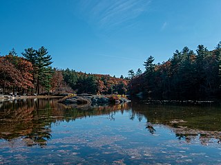
Breakheart Reservation is a public recreation area covering 652 acres (264 ha) in the towns of Saugus and Wakefield, Massachusetts. The reservation features a hardwood forest, two freshwater lakes, a winding stretch of the Saugus River, and scenic views of Boston and rural New England from rocky hilltops. The park is managed by the Massachusetts Department of Conservation and Recreation.

<span class="mw-page-title-main">Bartholomew's Cobble</span> National Natural Landmark in Massachusetts

Bartholomew's Cobble is a 329-acre (1.33 km2) National Natural Landmark, open space preserve, agricultural preserve, and bio-reserve located in southwest Massachusetts in the village of Ashley Falls abutting Canaan, Connecticut. The preserve contains more than 800 plant species, including North America's greatest diversity of ferns and the greatest overall biodiversity in Berkshire County, Massachusetts; it also contains Massachusetts' highest populations of ground nesting bobolinks. It was declared a National Natural Landmark in October 1971.

<span class="mw-page-title-main">Brooks Woodland Preserve</span>

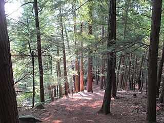
The Brooks Woodland Preserve is a 558-acre (226 ha) open space preserve located in Petersham, Massachusetts. The property, named after industrialist and diplomat James Wilson Brooks, is managed by the land conservation non-profit organization The Trustees of Reservations and offers 13 miles (21 km) of trails and primitive woods roads available for hiking, horseback riding, and cross country skiing. Second growth forest, overgrown farm fields, granite ledges, historic stone walls, creeks, and rolling hills characterize the preserve.

<span class="mw-page-title-main">Tully Trail</span> Scenic trail in Massachusetts, USA

The Tully Trail is a 22-mile (35 km) scenic loop trail located in the towns of Royalston, Orange, and Warwick, Massachusetts near the New Hampshire border. The route crosses several ledges with sweeping views of the surrounding rural countryside and passes three waterfalls. Tully Mountain, Jacobs Hill, and Tully Lake are also located on the trail. The Tully Trail coincides briefly with the 110-mile (180 km) Metacomet-Monadnock Trail. The route follows a mostly protected corridor of state, federal, and non-profit owned land.

<span class="mw-page-title-main">Royalston Falls</span> Waterfall

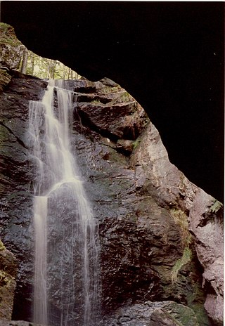
Royalston Falls is a 50 foot (15 m) waterfall and granite gorge located in Royalston, Massachusetts along Falls Brook, a tributary of the Tully River which in turn is a tributary of the Millers River. The falls are part of a 217-acre (88 ha) open space preserve acquired in 1951 by the land conservation non-profit organization The Trustees of Reservations. The 22-mile (35 km) Tully Trail and the 235-mile (378 km) New England National Scenic Trail pass through the property.

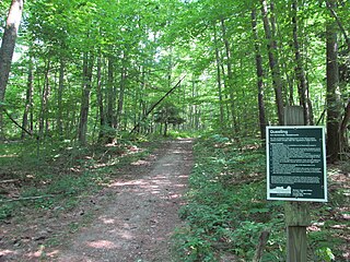
Sudbury Valley Trustees (SVT) is a regional open space land trust headquartered at Wolbach Farm in Sudbury, Massachusetts.

<span class="mw-page-title-main">Doane's Falls</span>

Doane's Falls is a series of five waterfalls located in Royalston, Massachusetts along an 0.2-mile (0.32 km) section of Lawrence Brook, a tributary of the Millers River that originates from Laurel Lake in Fitzwilliam. The falls are part of a 46-acre (19 ha) open space preserve acquired in 1959 by the land conservation non-profit organization The Trustees of Reservations. The 22-mile (35 km) Tully Trail passes through the property.

<span class="mw-page-title-main">Jacobs Hill</span>

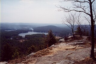
Jacobs Hill is a 173-acre (70 ha) open space preserve in Royalston, Massachusetts acquired in 1975 by the land conservation non-profit organization The Trustees of Reservations. The preserve includes scenic vistas, ledges, woodlands, a northern bog, and Spirit Falls, a 30 foot (9.1 m) waterfall. The 22-mile (35 km) Tully Trail passes through the property. Views from the ledges include the Berkshires as well as nearby Long Pond and the Tully River Valley, Tully Mountain, and Mount Grace.

<span class="mw-page-title-main">Quinebaug Woods</span>

Quinebaug Woods is a 36-acre (15 ha) open space preserve located in Holland, Massachusetts. The property, acquired in 2001 by the land conservation non-profit organization The Trustees of Reservations, is named for the Quinebaug River, which runs through the reservation.

<span class="mw-page-title-main">North Common Meadow</span>

North Common Meadow is a 25-acre (10 ha) open space preserve in the town of Petersham, Massachusetts. The property, part of a larger, contiguous area of protected open space including Harvard Forest and The Trustees of Reservations' Brooks Woodland Preserve, is maintained as grassland in keeping with the town's rural character.

<span class="mw-page-title-main">Slocum's River Reserve</span>

Slocum's River Reserve is a 47-acre (19 ha) open space preserve co-managed by the land conservation non-profit organizations The Trustees of Reservations and The Dartmouth Natural Resources Trust. The property includes 3,000 feet (910 m) of frontage along the tidal Slocum's River in Dartmouth, Massachusetts, 2 miles (3.2 km) of trails, woodland, agricultural fields, and pasture. The reserve is open to the public.

<span class="mw-page-title-main">Tully Lake</span> Dam in Royalston, Massachusetts

Tully Lake, of Royalston, Massachusetts, is a 1,262-acre (511 ha) reservoir and flood control project constructed by the United States Army Corps of Engineers (USACE) in 1949 for 1.6 million dollars. The project prevents flooding of the greater Connecticut River and Millers River valleys and provides a variety of recreational opportunities, including a campground operated by The Trustees of Reservations. Tully Lake is an important link in the 22-mile (35 km) Tully Trail.

<span class="mw-page-title-main">Cormier Woods</span> Historical site

Cormier Woods is a 175-acre (71 ha) open space preserve and historic 18th-century farm complex in Uxbridge, Massachusetts, USA, within the Blackstone River Valley National Heritage Corridor. The property is named for James Cormier, the former owner of the property. It was acquired in 2008 by the land conservation non-profit organization The Trustees of Reservations.

<span class="mw-page-title-main">Westport Town Farm</span>

Westport Town Farm is a 40-acre (16 ha) open space preserve and historic farm complex located in Westport, Massachusetts along the bracken East Branch of the Westport River. The property, owned by the town of Westport and managed by the land conservation non-profit organization The Trustees of Reservations through contract since 2007, was once the town's poor farm and local infirmary.

<span class="mw-page-title-main">Moose Hill Farm</span>

Moose Hill Farm is a 347-acre (140 ha) open space preserve and historic farm complex located in Sharon, Massachusetts near the 450 feet (140 m) summit of Moose Hill. The property, acquired in 2005 by the land conservation non-profit organization The Trustees of Reservations, includes farmland, woodlots, 21 farm buildings, hiking trails, stands of mature American Chestnuts, and scenic vistas of the Boston skyline. Moose Hill Farm is part of a larger area of protected open space including state land and the Massachusetts Audubon Society's Moose Hill Wildlife Sanctuary.

<span class="mw-page-title-main">Questing (New Marlborough, Massachusetts)</span> Massachusetts open space preserve

Questing is a 438-acre (177 ha) open space preserve and colonial era historic site located in New Marlborough, Massachusetts within The Berkshires. The property, acquired in 1996 by the land conservation non-profit organization The Trustees of Reservations, is named for a mythical beast from Arthurian Mythology called the Questing Beast.

<span class="mw-page-title-main">Notchview</span> Property in Massachusetts

Notchview is a 3,100-acre (13 km2) conservation property located on Massachusetts Route 9 in Windsor, Massachusetts in eastern Berkshire County, Massachusetts, United States. It is owned and managed by the Trustees of Reservations.

<span class="mw-page-title-main">Noanet Woodlands</span> Open space tract in Massachusetts

Noanet Woodlands is a 595-acre (241 ha) open space preserve located in Dover, Massachusetts. It is managed by the land conservation non-profit organization The Trustees of Reservations. The property has 17 miles (27 km) of hiking trails, several of which lead to the 387-foot summit of Noanet Peak, which offers a view of downtown Boston skyscrapers. The property's trail system connects to trails on two adjacent open space parcels: Powisset Farm, and Hale Education. Parking areas are at 93 Powisset Street and in Caryl Park, which is owned by the Town of Dover.

References

  1. "What We Do" The Trustees of Reservations. Retrieved June 28, 2021
  2. Places To Go. Trustees of Reservations. Retrieved June 28, 2021
  3. "The Friends of Mary Cummings Park" . Retrieved 23 February 2024.
  4. "Trustees Acquire 195-Acre Millborn Farm in Sherborn and Millis". Trustees of Reservations. Retrieved 23 March 2024.
  5. Moraine Farm
  6. Mount Ann Park
  7. "Tully Lake Campground Resurrected". Corps Lakes Gateway. US Army Corps of Engineers. Retrieved 23 February 2024.
  8. "Tully Lake". United States Army Corps of Engineers. Retrieved 23 February 2024.
  9. "Westport Town Farm". Westport Land Conservation Trust. Retrieved 23 February 2024.
  10. For information on the Property Guide, see the Publications section of the Frequently Asked Questions page