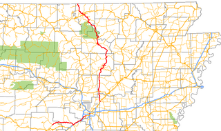
Highway 5 is a designation for three state highways in Arkansas. The southern segment of 44.99 miles (72.40 km) runs from Highway 7 in Hot Springs north to US Highway 70 (US 70) in Little Rock. A northern segment of 146.63 miles (235.98 km) begins at US Highway 67/US Highway 167 in Cabot and runs north to Missouri Route 5, including a lengthy overlap with Highway 25 between Heber Springs and Wolf Bayou. A portion of Highway 5 is designated as part of the Sylamore Scenic Byway.

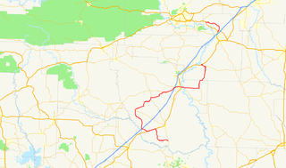
Highway 22 is an east–west state highway in the Arkansas River Valley. The highway runs 75.60 miles (121.67 km) from US 64/US 71B east to Highway 7 in Dardanelle. The highway is one of the original 1926 state highways, and is maintained by the Arkansas State Highway and Transportation Department (AHTD).
Arkansas Highway 10 is an east–west state highway in West Arkansas. The route runs 135.41 miles (217.92 km) from Oklahoma State Highway 120 near Hackett east to Interstate 30 in Little Rock, the state's capitol. The highway serves both the Fort Smith metropolitan area and the Little Rock – North Little Rock – Conway metropolitan area.

State Road 2 is a former east–west state highway in the Arkansas Timberlands and Lower Arkansas Delta. The route was approximately 195 miles (314 km), and ran from US Route 67 (US 67) in Texarkana east to cross the Mississippi River near Lake Village, continuing as Mississippi Highway 10. On July 1, 1931, the route was entirely replaced by US Highway 82 (US 82) by the American Association of State Highway Officials (AASHTO). The route was maintained by the Arkansas Highway Department (AHD), now known as the Arkansas Department of Transportation (ArDOT).

Fort Logan H. Roots was a military base located in North Little Rock, Arkansas, set on a high promontory overlooking the Arkansas River. The land was traded to the Federal Government in 1892 in exchange for the property now known as MacArthur Park, in Little Rock, which had been a military arsenal since the 1830s when Arkansas was a territory. The base was named for Congressman Logan H. Roots in recognition for his work in the negotiations.

U.S. Route 67 is a U.S. highway running from Presidio, Texas northeast to Sabula, Iowa. In the U.S. state of Arkansas, the route runs 279.15 miles (449.25 km) from the Texas border in Texarkana northeast to the Missouri border near Corning. The route passes through several cities and towns, including Hope, Benton, Little Rock, Jacksonville, Cabot, Beebe, Walnut Ridge, and Pocahontas.

Arkansas Highway 365 is a north–south state highway in Central Arkansas. The route of 69.31 miles (111.54 km) runs from US 65B/US 79B in Pine Bluff north through Little Rock to US 65B/AR 60 in Conway. The route is a redesignation of former U.S. Route 65, which has since been rerouted onto various Interstate highways through the area. Portions of Highway 365 in Jefferson County are former alignments of the Dollarway Road, which was the longest paved concrete road upon completion in 1913.

U.S. Route 62 is a U.S. highway running from El Paso, Texas northeast to Niagara Falls, New York. In the U.S. state of Arkansas, the route runs 329.9 miles from the Oklahoma border near Summers east to the Missouri border in St. Francis, serving the northern portion of the state. The route passes through several cities and towns, including Fayetteville, Springdale, Bentonville, Harrison, Mountain Home, Pocahontas, and also Piggott. US 62 runs concurrent with several highways in Arkansas including Interstate 49 and U.S. Route 71 between Fayetteville and Bentonville, U.S. Route 412 through much of the state, U.S. Route 65 in the Harrison area, and with U.S. Route 63 and U.S. Route 67 in northeast Arkansas.
Seven segments of the historic Natchez Trace are listed on the National Register of Historic Places (NRHP). Also there are additional NRHP-listed structures and other sites along the Natchez Trace, which served the travelers of the trace and survive from the era of its active use.

Highway 190 is a designation for four state highways in Arkansas. Three are low-traffic rural highways in Grant County, with one designation along city streets in Pine Bluff. The rural segments were created in 1965 and 1966, with the Pine Bluff section created in 2000. All segments are maintained by the Arkansas Department of Transportation (ARDOT).
The Memphis to Little Rock Road-Village Creek Segment is a historic military road in Cross County, Arkansas. Located entirely within Village Creek State Park, this 1.5-mile (2.4 km) segment of roadway is one of the best-preserved portions of the military road built between Memphis, Tennessee and Little Rock, Arkansas in 1828. This road is notable for the large numbers of westward-traveling pioneers who used it en route to settling the American Plains, and for its use in the forced migration of several Native American tribes in the 1830s. The roadway portion, in parts set in dramatically deep cuts in the hills, extends from Village Creek in the east to the western boundary of the park, and is accessible today as a hiking trail.
The Memphis to Little Rock Road-Strong's Ferry Segment is a historic military road in eastern Cross County, Arkansas. This segment of roadway is one of the best-preserved portions of the military road built between Memphis, Tennessee and Little Rock, Arkansas in 1828. This road is notable for the large numbers of westward-traveling pioneers who used it en route to settling the American Plains, and for its use in the forced migration of several Native American tribes in the 1830s. This roadway portion extends from the site of a former ferry crossing on the St. Francis River, westward toward Village Creek State Park, where there is another surviving segment that is hikable.

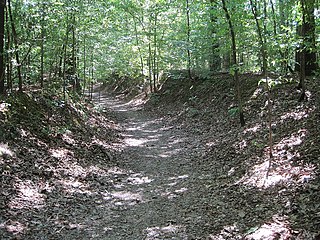
The Springfield to Fayetteville Road-Cross Hollow Segment is a 2-mile (3.2 km) section of a historic 19th-century road in Benton County, Arkansas. The road is now designated Old Wire Road, and the historic segment runs northward from its junction with County Road 620, northeast of Lowell. This road bed is a part of one of the first roads built in the area, running from Fayetteville, Arkansas to Springfield, Missouri. Built in 1835, the road bed has its original width and original embankments. The road is notable as part of the northern route of the Trail of Tears, when Native Americans living east of the Mississippi River were forcibly relocated to what is now Oklahoma, and for its use in military operations during the American Civil War. It is the longest known intact segment of the Trail of Tears in Arkansas.

The Memphis to Little Rock Road-Henard Cemetery Road Segment is a section of historic roadway in Monroe County, Arkansas. It consists of 650 metres (2,130 ft) of the middle of Henard Cemetery Road, located northeast of the hamlet of Zent in the far northeastern part of the county. The roadway section is one of three known places where the original 19th-century appearance of the first road to connect Memphis, Tennessee to Little Rock, Arkansas is preserved. The far ends of the road have been impacted by development and agriculture, and do not convey the sense of the road's early appearance. The road is also historically important as it was used as part of the Trail of Tears, the forced removal of Native Americans east of the Mississippi River to what is now Oklahoma.
The Memphis to Little Rock Road-Bayou Two Prairie Segment is a historic military road section in Lonoke County, Arkansas. Located north of Lonoke near the hamlet of Brownsville, the road section was part of the 1828 Memphis to Little Rock Military Road. It was used in the 1830s during the Trail of Tears removal of eastern Native American tribes, and was used by military forces on both sides of the American Civil War leading up to the Battle of Brownsville.
The Memphis to Little Rock Road-Brownsville Segment is a historic military road section in Lonoke County, Arkansas. Located north of Lonoke near the hamlet of Brownsville, the road section was part of the 1828 Memphis to Little Rock Military Road. It was used in the 1830s during the Trail of Tears removal of eastern Native American tribes, and was used by military forces on both sides of the American Civil War leading up to the Battle of Brownsville.
The Military Road-Cadron Segment is a portion of 19th-century roadway in Faulkner County, Arkansas, near the city of Conway. It consists of an original section of a military road built in the mid-1830s between Little Rock and the military outpost at Fort Smith, through what was then frontier territory. It is one of the only known surviving sections of the early military roads that crossed the Arkansas Territory, which is located west of Little Rock. The road is further notable as one of the routes by which Native Americans were relocated to Indian Territory from points east of the Mississippi River.
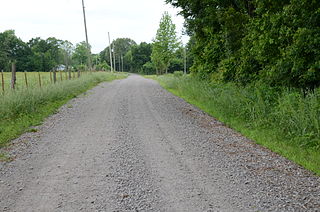
The Little Rock to Cantonment Gibson Road-Old Wire Road Segment is a historic road section in Conway County, Arkansas. It consists of a section of Old Wire Road, southwest of the hamlet of Blackwell, which is about 300 metres (980 ft) long and 18 feet (5.5 m) wide. It is defined in part by the cut through which it passes, with steep banks on either side. Built in 1827, it is one of the oldest surviving road alignments of the military road built between Little Rock, and what is now Fort Gibson in Oklahoma. This route formed part of the Trail of Tears, the historic removal of Native Americans to the Indian Territory that is now Oklahoma.
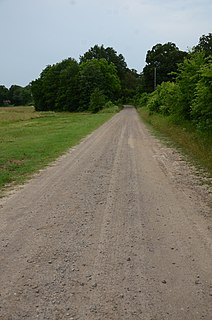
The Little Rock to Cantonment Gibson Rd-Fourth Street Segment is a history stretch of 19th-century roadbed in rural Pope County, Arkansas. It consists of about one mile of gravel roadway, now designated Fourth Street, east of Atkins, extending from Union Grove Loop in the west to Oakland Drive in the east. It is about 18 feet (5.5 m) wide, and is built on an embankment for much of its length. Completed by early 1828 as a military road connecting Little Rock to what is now Fort Gibson in Oklahoma, the road is historically significant for its use as part of the Trail of Tears removal of eastern Native Americans to the Indian Territory that is now Oklahoma.
Highway 51 is a designation for two north–south state highways in Southwest Arkansas. One route of 53.37 miles (85.89 km) begins Highway 53 near Whelen Springs and runs north to US Highway 67 in Donaldson. A second route of 7.92 miles (12.75 km) runs parallel to US 270 northwest of Malvern. Both routes are maintained by the Arkansas Department of Transportation (ArDOT).