Locations in New Zealand with a Scottish name

Last updated

This is a list of placenames in Scotland which have subsequently been applied to parts of New Zealand by Scottish emigrants or explorers.

Contents

The South Island also contains the Strath-Taieri and the Ben Ohau Range of mountains, both combining Scots Gaelic and Māori origins, as does Glentaki, in the lower valley of the Waitaki River. Invercargill has the appearance of a Scottish name, since it combines the Scottish prefix "Inver" (Inbhir), meaning a river's mouth, with "Cargill", the name of Scottish early settler William Cargill. (Invercargill's main streets are named after Scottish rivers, e.g.;, Dee, Tay, Spey, Esk, Don, Doon, Clyde.) Inchbonnie is a hybrid of Lowland Scots and Scottish Gaelic.

North Island

Rothesay Bay Beach with Rangitoto Island in the distance in the Hauraki Gulf. Rothesay.JPG
Rothesay Bay Beach with Rangitoto Island in the distance in the Hauraki Gulf.
Panorama of Wellington including the Kelburn cable car. WellingtonPanorama.jpg
Panorama of Wellington including the Kelburn cable car.

South Island

Cnr of Esk and Dee Streets, looking up Esk st, one of the main shopping streets of Invercargill. Esk Street Invercargill NZ.jpg
Cnr of Esk and Dee Streets, looking up Esk st, one of the main shopping streets of Invercargill.
Looking at Lake Wakatipu from Glenorchy Glenorchy wharf.jpg
Looking at Lake Wakatipu from Glenorchy
View of the Clutha River towards Roxburgh Bridge. RoxburghBridge.jpg
View of the Clutha River towards Roxburgh Bridge.
Upper reaches of the Water of Leith, Woodhaugh, Dunedin LeithValley, Dunedin, NZ.jpg
Upper reaches of the Water of Leith, Woodhaugh, Dunedin
Sutherland Falls Sutherland Falls.jpg
Sutherland Falls

Stewart Island (Rakiura)

Satellite image of Stewart Island / Rakiura Stewart Island.jpg
Satellite image of Stewart Island / Rakiura
Temperate rainforest on Ulva Island Ulva Island rainforest.jpg
Temperate rainforest on Ulva Island
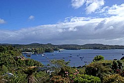
Overlooking Oban and Halfmoon Bay on Stewart Island Oban Stewart Island.jpg
Overlooking Oban and Halfmoon Bay on Stewart Island

Auckland Islands

See also

180deg view of Dunedin, New Zealand shot from the hills on the west. Mount Cargill is at the extreme left of picture, and the Otago Peninsula is beyond the harbour to the centre. Dunedin Panorama.jpg
180° view of Dunedin, New Zealand shot from the hills on the west. Mount Cargill is at the extreme left of picture, and the Otago Peninsula is beyond the harbour to the centre.

Related Research Articles

<span class="mw-page-title-main">Fort William, Scotland</span> Town in the Highlands of Scotland

Fort William is a town in Lochaber in the Scottish Highlands, located on the eastern shore of Loch Linnhe. At the 2011 census, Fort William had a population of 10,459, making it the second largest settlement in both the Highland council area, and the whole of the Scottish Highlands; only the city of Inverness has a larger population.

<span class="mw-page-title-main">Scottish Highlands</span> Cultural and historical region of Scotland

The Highlands is a historical region of Scotland. Culturally, the Highlands and the Lowlands diverged from the Late Middle Ages into the modern period, when Lowland Scots language replaced Scottish Gaelic throughout most of the Lowlands. The term is also used for the area north and west of the Highland Boundary Fault, although the exact boundaries are not clearly defined, particularly to the east. The Great Glen divides the Grampian Mountains to the southeast from the Northwest Highlands. The Scottish Gaelic name of A' Ghàidhealtachd literally means "the place of the Gaels" and traditionally, from a Gaelic-speaking point of view, includes both the Western Isles and the Highlands.

<span class="mw-page-title-main">Glen</span> Name for valley commonly used in Ireland, Scotland and the Isle of Man

A glen is a valley, typically one that is long and bounded by gently sloped concave sides, unlike a ravine, which is deep and bounded by steep slopes. The word is Goidelic in origin: gleann in Irish and Scottish Gaelic, glion in Manx. The designation "glen" also occurs often in place names. Glens are appreciated by tourists for their tranquility and scenery.

Firth is a word in the English and Scots languages used to denote various coastal waters in the United Kingdom, predominantly within Scotland. In the Northern Isles, it more often refers to a smaller inlet. It is linguistically cognate to fjord, which has a more constrained sense in English. Bodies of water named "firths" tend to be more common on the Scottish east coast, or in the southwest of the country, although the Firth of Clyde is an exception to this. The Highland coast contains numerous estuaries, straits, and inlets of a similar kind, but not called "firth" ; instead, these are often called sea lochs. Before about 1850, the spelling "Frith" was more common.

<span class="mw-page-title-main">Firth of Clyde</span> Inlet on the west coast of Scotland

The Firth of Clyde is the mouth of the River Clyde. It is located on the west coast of Scotland and constitutes the deepest coastal waters in the British Isles. The firth is sheltered from the Atlantic Ocean by the Kintyre peninsula, which encloses the outer firth in Argyll and Ayrshire. The Kilbrannan Sound is a large arm of the Firth of Clyde, separating the Kintyre Peninsula from the Isle of Arran. Within the Firth of Clyde is another major island – the Isle of Bute. Given its strategic location at the entrance to the middle and upper Clyde, Bute played a vital naval military role during World War II.

<span class="mw-page-title-main">Dunoon</span> Town in Scotland

Dunoon is the main town on the Cowal peninsula in the south of Argyll and Bute, Scotland. It is located on the western shore of the upper Firth of Clyde, to the south of the Holy Loch and to the north of Innellan. As well as forming part of the council area of Argyll and Bute, Dunoon also has its own community council. Dunoon was a burgh until 1976.

<span class="mw-page-title-main">Holy Loch</span> Sea loch in Argyll and Bute, Scotland

The Holy Loch is a sea loch, a part of the Cowal peninsula coast of the Firth of Clyde, in Argyll and Bute, Scotland.

<span class="mw-page-title-main">Loch Long</span> Sea-loch in Argyll and Bute, Scotland, UK

Loch Long is a body of water in the council area of Argyll and Bute, Scotland. The Sea Loch extends from the Firth of Clyde at its southwestern end. It measures approximately 20 miles in length, with a width of between one and two miles. The loch also has an arm, Loch Goil, on its western side.

<span class="mw-page-title-main">Lochnagar</span> Mountain in the Grampians, Scotland

Lochnagar or Beinn Chìochan is a mountain in the Mounth, in the Grampians of Scotland. It is about five miles south of the River Dee near Balmoral. It is a popular hill with hillwalkers, and is a noted venue for summer and winter climbing.

<span class="mw-page-title-main">Kyles of Bute</span> Channel in Argyll and Bute, Scotland, UK

The Kyles of Bute form a narrow sea channel that separates the northern end of the Isle of Bute from the Cowal peninsula in Argyll and Bute, on the Scottish mainland. The surrounding hillsides are roughly wooded, and overlooked by rocky tops and areas of moorland.

<span class="mw-page-title-main">Geography of Scotland</span> Geographical features of Scotland

The geography of Scotland is varied, from rural lowlands to unspoilt uplands, and from large cities to sparsely inhabited islands. Located in Northern Europe, Scotland comprises the northern part of the island of Great Britain as well as 790 surrounding islands encompassing the major archipelagos of the Shetland Islands, Orkney Islands and the Inner and Outer Hebrides. The only land border is with England, which runs for 96 miles in a northeasterly direction from the Solway Firth in the west to the North Sea on the east coast. Separated by the North Channel, the island of Ireland lies 13 nautical miles from Mull of Kintyre on the Scottish mainland. Norway is located 190 nmi (350 km) northeast of Scotland across the North Sea. The Atlantic Ocean, which fringes the coastline of western and northern Scotland and its islands, influences the temperate, maritime climate of the country.

<span class="mw-page-title-main">Rosneath</span> Human settlement in Scotland

Rosneath is a village in Argyll and Bute, Scotland. It sits on the western shore of the Gare Loch, 2 miles northwest of the tip of the Rosneath Peninsula. It is about 2.4 miles by road from the village of Kilcreggan, which is sited on the southern shore of the peninsula, on the Firth of Clyde.

<span class="mw-page-title-main">Locations in Australia with a Scottish name</span>

This is a list of placenames in Scotland which have subsequently been applied to parts of Australia by Scottish emigrants or explorers.

Scottish New Zealanders are New Zealanders of Scottish ancestry or who originate from Scotland. The number of New Zealanders who are descended from Scots is unknown, as the New Zealand census asks for ethnicity, not ancestry, and most have now assimilated; nonetheless, the vast majority of Pākehā, or European New Zealanders are of British and Irish descent, and it has been estimated that 1-2 million New Zealanders have roots in Scotland. This includes many Māori, as a large proportion of which have European roots as well. Most Scottish New Zealanders live in New Zealand's deep southern regions of Otago and Southland, New Zealand, where they have had a substantial influence. Scottish influence on Dunedin, one of New Zealand's most historically important cities was profound, and Presbyterianism is the major religion south of Christchurch. In some parts of Otago but all of Murihiku, there is a distinct accent known as the "Southland Brrr", which differs from mainstream New Zealand English for being strongly rhotic.

<span class="mw-page-title-main">Lewis and Harris</span> Largest island in Scotland, part of the Outer Hebrides

Lewis and Harris, or Lewis with Harris, is a single Scottish island in the Outer Hebrides, divided by mountains. It is the largest island in Scotland and the third largest in the British Isles, after Great Britain and the island of Ireland, with an area of 841 square miles (2,178 km2), which is approximately 1% of the area of Great Britain. The northern two-thirds is called [the Isle of] Lewis and the southern third [the Isle of] Harris; each is referred to as if it were a separate island and there are many cultural and linguistic differences between the two.

<span class="mw-page-title-main">Ben Nevis and Glen Coe National Scenic Area</span>

Ben Nevis and Glen Coe is a national scenic area (NSA) covering part of the Highlands of Scotland surrounding Ben Nevis and Glen Coe, in which certain forms of development are restricted. It is one of 40 such areas in Scotland, which are defined so as to identify areas of exceptional scenery and to ensure its protection from inappropriate development. The Ben Nevis and Glen Coe NSA covers 903 km2 (349 sq mi) of land, lying within the Highland, Argyll and Bute and Perth and Kinross council areas. A further 19 km2 (7.3 sq mi) of the NSA are marine, covering the sea loch of Loch Leven.

References

  1. 1 2 "Scottish Place Names - Christchurch, New Zealand". rampantscotland.com.
  2. "Bryndwr and Burnside". christchurchcitylibraries.com.