The Chesapeake and Ohio Canal, abbreviated as the C&O Canal and occasionally called the Grand Old Ditch, operated from 1831 until 1924 along the Potomac River between Washington, D.C. and Cumberland, Maryland. It replaced the Potomac Canal, which shut down completely in 1828, and could operate during months in which the water level was too low for the former canal. The canal's principal cargo was coal from the Allegheny Mountains.

The National Mall is a landscaped park near the downtown area of Washington, D.C., the capital city of the United States. It contains and borders a number of museums of the Smithsonian Institution, art galleries, cultural institutions, and various memorials, sculptures, and statues. It is administered by the National Park Service (NPS) of the United States Department of the Interior as part of the National Mall and Memorial Parks unit of the National Park System. The park receives approximately 24 million visitors each year.

Georgetown is a historic neighborhood and commercial district in Northwest Washington, D.C., situated along the Potomac River. Founded in 1751 as part of the colonial-era Province of Maryland, Georgetown predated the establishment of Washington, D.C. by 40 years. Georgetown was an independent municipality until 1871 when the United States Congress created a new consolidated government for the entire District of Columbia. A separate act, passed in 1895, repealed Georgetown's remaining local ordinances and renamed Georgetown's streets to conform with those in Washington, D.C..

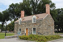
The Chesapeake and Ohio Canal National Historical Park is located in the District of Columbia and the state of Maryland. The park was established in 1961 as a National Monument by President Dwight D. Eisenhower to preserve the neglected remains of the Chesapeake and Ohio Canal and many of its original structures.

Constitution Avenue is a major east–west street in the northwest and northeast quadrants of the city of Washington, D.C., in the United States. It was originally known as B Street, and its western section was greatly lengthened and widened between 1925 and 1933. It received its current name on February 26, 1931, though it was almost named Jefferson Avenue in honor of Thomas Jefferson.

The history of Washington, D.C., is tied to its role as the capital of the United States. The site of the District of Columbia along the Potomac River was first selected by President George Washington. The city came under attack during the War of 1812 in an episode known as the Burning of Washington. Upon the government's return to the capital, it had to manage the reconstruction of numerous public buildings, including the White House and the United States Capitol. The McMillan Plan of 1901 helped restore and beautify the downtown core area, including establishing the National Mall, along with numerous monuments and museums.

There are many outdoor sculptures in Washington, D.C. In addition to the capital's most famous monuments and memorials, many figures recognized as national heroes have been posthumously awarded with his or her own statue in a park or public square. Some figures appear on several statues: Abraham Lincoln, for example, has at least three likenesses, including those at the Lincoln Memorial, in Lincoln Park, and the old Superior Court of the District of Columbia. A number of international figures, such as Mohandas Gandhi, have also been immortalized with statues. The Statue of Freedom is a 19½-foot tall allegorical statue that rests atop the United States Capitol dome.

16th Street Northwest, briefly known as the Avenue of the Presidents, is a prominent north-south boulevard in Washington, D.C., located in Northwest D.C. The street was laid out as part of the 1791 L'Enfant Plan, which served as the original blueprint for the city. The street begins just north of the White House, across from Lafayette Square in the President's Park, and continues north along the Washington meridian until Blair Circle.
National Mall and Memorial Parks is an administrative unit of the National Park Service (NPS) encompassing many national memorials and other areas in Washington, D.C. Federally owned and administered parks in the capital area date back to 1790, some of the oldest in the United States. In 1933, they were transferred to the control of the National Park Service. These parks were known as the National Capital Parks from their inception until 1965. The NPS now operates multiple park groupings in the D.C. area, including National Capital Parks-East, Rock Creek Park, President's Park, and George Washington Memorial Parkway. National Mall and Memorial Parks also provides technical assistance for the United States Navy Memorial.
This is a list of properties and districts in Washington, D.C., on the National Register of Historic Places. There are more than 600 listings, including 74 National Historic Landmarks of the United States and another 13 places otherwise designated as historic sites of national importance by Congress or the President.

Tiber Creek or Tyber Creek, originally named Goose Creek, is a tributary of the Potomac River in Washington, D.C. It was a free-flowing creek until 1815, when it was channeled to become part of the Washington City Canal. Presently, it flows under the city in tunnels, including under Constitution Avenue NW.
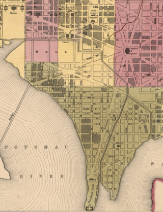
The Washington City Canal was a canal in Washington, D.C., that operated from 1815 until the mid-1850s. The canal connected the Anacostia River, termed the "Eastern Branch" at that time, to Tiber Creek, the Potomac River, and later the Chesapeake and Ohio (C&O) Canal. The canal fell into disuse during the late 19th century and the city government covered over or filled in various sections in 1871.

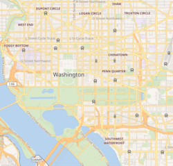
Downtown is the central business district of Washington, D.C., located in Northwest D.C. It is the third largest central business district in the United States. The "Traditional Downtown" has been defined as an area roughly between Union Station in the east and 16th Street NW in the west, and between the National Mall on the south and Massachusetts Avenue on the north, including Penn Quarter. However, nowadays, Downtown D.C. usually refers to a larger area, as the DC Office of Planning states:
…most residents, workers, and visitors think of Downtown in a broader sense — including areas as far north as Dupont Circle, as far west as Foggy Bottom, and as far east as Capitol Hill. Only about half of the central city workforce is located within the city’s traditional Downtown.
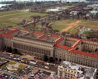
The Herbert C. Hoover Building is the Washington, D.C. headquarters of the United States Department of Commerce.

The U.S. Capitol Gatehouses and Gateposts — designed circa 1827 by celebrated architect Charles Bulfinch — originally stood on the grounds of the United States Capitol in Washington, D.C. Two of the gatehouses are listed on the National Register of Historic Places in their new locations.
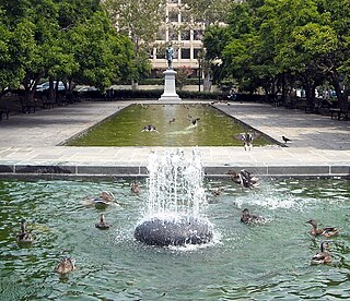
Rawlins Park is a rectangular public park in the Foggy Bottom neighborhood of Washington, D.C., two blocks west of the White House grounds and two blocks north of the National Mall. The boundaries of the park are 18th Street NW to the east, E Street NW to the south and north, and 19th Street NW to the west. The park was an undeveloped open space for many years, until plans were made to install the statue of John Aaron Rawlins in 1874. Various improvements were made, but the area surrounding the park remained mostly undeveloped. This changed in the 1890s when the area was cleared of marshes, and houses were built on the park's southern border.

The Baltimore and Potomac Railroad Station, also known as Pennsylvania Railroad Station, was a railroad station that was owned by the Pennsylvania Railroad and operated by the Baltimore and Potomac Railroad in Washington, D.C., from July 2, 1872 until its closure in 1907. It was located at the southern corner of 6th street NW and B Street NW, now the site of the West Building of the National Gallery of Art. It was in this train station that United States President James A. Garfield was assassinated by Charles Guiteau.

Murder Bay was a disreputable slum in Washington, D.C., roughly bounded by Constitution Avenue NW, Pennsylvania Avenue NW, and 13th and 15th Streets NW. The area was a center of crime through the early 20th century, with an extensive criminal underclass and prostitution occurring in several brothels and hotels in the area. The area was completely rebuilt during the construction of the Federal Triangle project in the late 1920s and 1930s.
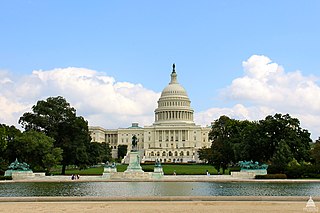
Union Square is an 11-acre public plaza at the foot of Capitol Hill in Washington, D.C., United States. It encompasses the Ulysses S. Grant Memorial (1924) and the 6-acre Capitol Reflecting Pool (1971) and is just west of the United States Capitol building. Views differ as to whether the Square is just east of the National Mall or is itself the eastern end.
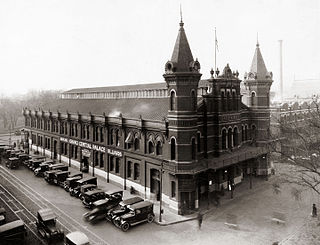
Center Market was a market hall in Washington, D.C. designed by architect Adolph Cluss which operated in Washington, DC from 1872 to 1931. The building was demolished in 1931 to be replaced by the National Archives Building. A market called Center Market had been in operation on the same block of land since 1802. In 1931, the name of Center Market was transferred over to the Northern Liberty Market located a few blocks north.