
Hays is a census-designated place (CDP) in Blaine County, Montana, United States. The population was 843 at the 2010 census. The community lies within the Fort Belknap Indian Reservation, near the reservation's southern end. The nearby community of Lodge Pole lies to the east.

Fort Assinniboine was a United States Army fort located in present-day north central Montana. It was built in 1879 and operated by the Army through 1911. The 10th Cavalry Buffalo Soldiers, made up of African-American soldiers, were among the units making up the garrison at the fort. Determining that this fort was no longer needed after the end of the Indian Wars, the US Army closed and abandoned it.

Maquoketa Caves State Park is a state park of Iowa, United States, located in Jackson County. It stands northwest of the city of Maquoketa. In 1991 111 acres (45 ha) on the east side of the park were listed as a historic district on the National Register of Historic Places.
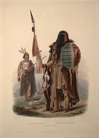
The Assiniboine or Assiniboin people, also known as the Hohe and known by the endonym Nakota, are a First Nations/Native American people originally from the Northern Great Plains of North America.

Whitewater State Park is a state park of Minnesota, United States, preserving a stretch of the Whitewater River surrounded by rocky bluffs. It is located in Winona County in the southeastern blufflands area of the state. The 2,700-acre (11 km2) park features scenic overlooks and trout fishing in the spring-fed Whitewater River and Trout Run Creek. It has about 300,000 visitors annually, and is located 7 miles (11 km) north of St. Charles on Minnesota State Highway 74, which runs through the park.

The Gros Ventre, also known as the Aaniiih, A'aninin, Haaninin, Atsina, and White Clay, are a historically Algonquian-speaking Native American tribe located in northcentral Montana. Today, the Gros Ventre people are enrolled in the Fort Belknap Indian Community of the Fort Belknap Reservation of Montana, a federally recognized tribe with 7,000 members, also including the Assiniboine people.

Fort Peck Community College (FPCC) is a public tribal land-grant community college in Poplar, Montana. The college is located on the Fort Peck Assiniboine & Sioux Reservation in the northeast corner of Montana, which encompasses over two million acres. The college also has a satellite campus in Wolf Point.
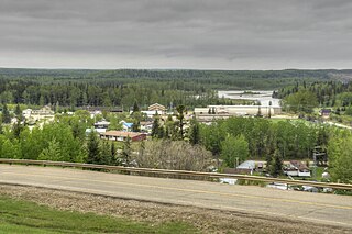
Fort Assiniboine is a hamlet in northwest Alberta, Canada, within Woodlands County. It is located along the north shore of the Athabasca River at the junction of Highway 33 and Highway 661. It is approximately 39 kilometres (24 mi) northwest of Barrhead, 62 kilometres (39 mi) southeast of Swan Hills and 91 kilometres (57 mi) northeast of Whitecourt.

Scenic State Park is a Minnesota state park near Bigfork in Itasca County. It encompasses 3,936 acres (1,593 ha) of virgin pine forests that surround Sandwick Lake and Coon Lake. It also includes portions of Lake of the Isles, Tell Lake, Cedar Lake, and Pine Lake. Established in 1921, the Ojibwe tribe had previously used the area for hunting. The park has places for camping, hiking, swimming, fishing, and canoeing.

The Fort Belknap Indian Reservation is shared by two Native American tribes, the A'aninin and the Nakoda (Assiniboine). The reservation covers 1,014 sq mi (2,630 km2), and is located in north-central Montana. The total area includes the main portion of their homeland and off-reservation trust land. The tribes reported 2,851 enrolled members in 2010. The capital and largest community is Fort Belknap Agency, at the reservation's north end, just south of the city of Harlem, Montana, across the Milk River.

Westmoreland State Park lies within Westmoreland County, Virginia. The park extends about one and a half miles along the Potomac River and covers 1,321 acres. The Horsehead Cliffs provide visitors with a panoramic view of the Potomac River, and lower levels feature fossils and beach access. The park offers hiking, camping, cabins, fishing, boating and swimming, although mechanical issues have kept the swimming pool closed since 2021. Located on the Northern Neck Peninsula, the park is close to historical sites featuring earlier eras: George Washington's birthplace and Stratford Hall, the birthplace of Robert E. Lee.

The Northeast Entrance Station to Yellowstone National Park, in Park County, Montana, is a rustic log building designed by the National Park Service Branch of Plans and Design under the direction of Thomas Chalmers Vint and built in 1935. The entrance station straddles U.S. Route 212 (US 212) west of Silver Gate. A combined ranger station and residence is located nearby. All buildings were constructed by George Larkin of Gardiner, Montana.

Copper Falls State Park is a 3,068-acre (1,242 ha) state park in Wisconsin. The park contains a section of the Bad River and its tributary the Tylers Forks, which flow through a gorge and drop over several waterfalls. Old Copper Culture Indians and later European settlers mined copper in the area. The state park was created in 1929 and amenities were developed by the Civilian Conservation Corps and the Works Progress Administration. In 2005 the park was listed on the National Register of Historic Places as a site with 10 contributing properties.

The Detroit Naval Armory is located at 7600 East Jefferson Avenue in Detroit, Michigan. It is also known as the R. Thornton Brodhead Armory. The armory was designated a Michigan State Historic Site in 1980 and listed on the National Register of Historic Places in 1994.
The Sanders Gymnasium and Community Hall, located in Sanders, Montana, was added to the National Register of Historic Places in 1997.
Camp Paxson Boy Scout Camp, located on the western shore of Seeley Lake, Lolo National Forest, Montana, is on the National Register of Historic Places. It started out as a summer camp for the Boy Scouts of America (BSA), and is named in honor of Montana western painter Edgar Samuel Paxson. The United States Forest Service granted the Western Montana Council of the BSA permission to build a summer camp, originally with six small 12x24' clapboard structures and tents on just 4 acres (1.6 ha), in 1924. The camp was expanded beginning in October 1939, with more facilities constructed by the Works Progress Administration and Civilian Conservation Corps (CCC). The camp was completed in 1940 on 6.7 acres (2.7 ha) under the supervision of Forest Service engineer Clyde Fickes.
Architects of the National Park Service are the architects and landscape architects who were employed by the National Park Service (NPS) starting in 1918 to design buildings, structures, roads, trails and other features in the United States National Parks. Many of their works are listed on the National Register of Historic Places, and a number have also been designated as National Historic Landmarks.

Waverly Village Hall is a municipal event hall in Waverly, Minnesota, United States, built by the Works Progress Administration (WPA) from 1939 to 1940. It was listed on the National Register of Historic Places in 2002 for its local significance in the themes of architecture, entertainment/recreation, and government/politics. It was nominated as a representative of the civic facilities made possible with New Deal federal assistance, as well as for its Moderne architecture and role as a community event space.
Gilbert Horn Sr. was an American military veteran who served as an Assiniboine code talker during World War II. Horn, a member of the Merrill's Marauders during the war, utilized the Assiniboine language to encode communications by the U.S. military in the Pacific theater. In 2014, Horn was named an honorary chief by the Fort Belknap Assiniboine Tribe, becoming the first person to be awarded the title since the 1890s.

