Sutter's Fort was a 19th-century agricultural and trade colony in the Mexican Alta California province. Established in 1839, the site of the fort was originally called New Helvetia by its builder John Sutter, though construction of the fort proper would not begin until 1841. The fort was the first non-indigenous community in the California Central Valley. The fort is famous for its association with the Donner Party, the California Gold Rush, and the formation of the city of Sacramento, surrounding the fort. It is notable for its proximity to the end of the California Trail and Siskiyou Trails, which it served as a waystation.

The Presidio of San Francisco is a park and former U.S. Army post on the northern tip of the San Francisco Peninsula in San Francisco, California, and is part of the Golden Gate National Recreation Area.

Mission San Carlos Borromeo del Río Carmelo, or Misión de San Carlos Borromeo de Carmelo, first built in 1797, is one of the most authentically restored Catholic mission churches in California. Located at the mouth of Carmel Valley, California, it is on the National Register of Historic Places and is a National Historic Landmark.

Northern California is a geographic and cultural region that generally comprises the northern portion of the U.S. state of California. Spanning the state's northernmost 48 counties, its main population centers include the San Francisco Bay Area, the Greater Sacramento area, the Redding, California, area south of the Cascade Range, and the Metropolitan Fresno area. Northern California also contains redwood forests, along with most of the Sierra Nevada, including Yosemite Valley and part of Lake Tahoe, Mount Shasta, and most of the Central Valley, one of the world's most productive agricultural regions.

The Native Sons of the Golden West is a fraternal service organization founded in the U.S. state of California in 1875, dedicated to historic preservation and documentation of the state's historic structures and places, the placement of historic plaques, and other charitable functions in California. In 1890 they placed California's first marker honoring the discovery of gold, which gave rise to the state nickname "The Golden State". U.S. President Richard M. Nixon and Chief Justice Earl Warren were NSGW presidents.
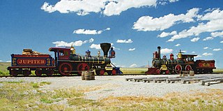
Golden Spike National Historical Park is a United States National Historical Park located at Promontory Summit, north of the Great Salt Lake in east-central Box Elder County, Utah, United States. The nearest city is Corinne, approximately 23 miles (37 km) east-southeast of the site.

The California State Capitol is the seat of the California state government, located in Sacramento, the state capital of California. The building houses the chambers of the California State Legislature, made up of the Assembly and the Senate, along with the office of the governor of California. The Neoclassical structure, designed by Reuben S. Clark, was completed between 1861 and 1874. Located at the west end of Capitol Park and the east end of the Capitol Mall, the building was added to the National Register of Historic Places in 1973. The California State Capitol Museum is housed on the grounds of the capitol.

El Presidio Real de Santa Bárbara, also known as the Royal Presidio of Santa Barbara, is a former military installation in Santa Barbara, California, United States. The presidio was built by Spain in 1782, with the mission of defending the Second Military District in California. In modern times, the Presidio serves as a significant tourist attraction, museum and an active archaeological site as part of El Presidio de Santa Barbara State Historic Park.

The Eldridge Street Synagogue is a synagogue and National Historic Landmark in Chinatown, Manhattan, New York City. Built in 1887, it is one of the first synagogues erected in the United States by Eastern European Jews.

Rancho Petaluma Adobe is a historic ranch house in Sonoma County, California. It was built from adobe bricks in 1836 by order of Mariano Guadalupe Vallejo. It was the largest privately owned adobe structure built in California and is the largest example of the Monterey Colonial style of architecture in the United States. A section of the former ranch has been preserved by the Petaluma Adobe State Historic Park and it is both a California Historic Landmark and a National Historic Landmark. The Rancho Petaluma Adobe State Historic Park is located on Adobe Road on the east side of the present-day town of Petaluma, California.

Architectural Resources Group is a firm that was founded in 1980 by Bruce Judd and Steve Farneth in San Francisco, CA. It began by providing professional services in the fields of architecture and urban planning with particular expertise in the area of historic preservation. In 2000, David Wessel, a Principal of ARG, founded a separate conservation-contracting division, ARG Conservation Services which operates under the same roof as ARG. By 2005, the firm had expanded to a full-service architecture firm with 50+ employees. ARG also opened offices in Pasadena serving Southern California, and Portland, Oregon, serving the Pacific Northwest.

The McDonald's Sign, also known as McDonald's Store #433 Sign, in Pine Bluff, Arkansas, United States, is one of only a few surviving examples of a single-arch McDonald's sign. The sign was erected in 1962 and remained at its original location until 2007. That year, McDonald's Store #433 moved and the sign was renovated and moved to the new location. The McDonald's sign was added to the U.S. National Register of Historic Places in 2006.

Sonoma Plaza is the central plaza of Sonoma, California. The plaza, the largest in California, was laid out in 1835 by Mariano Guadalupe Vallejo, founder of Sonoma.

The First Baptist Church, also known as the Bell Towers, is a historic church complex built in 1931 in Bakersfield, California. The church moved to a new campus in 1977 and the building presently used as an office building. The structure was placed on the National Register of Historic Places (NRHP) on January 2, 1979.
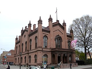
Flushing Town Hall is a historic Town Hall located on Northern Boulevard at Linden Place in the Flushing section of the New York City borough of Queens. Formerly, it served as the seat of government of the village of Flushing, established as Vlissingen in 1645, until the consolidation with New York City in 1898. It was built in 1862 and is a 2-story, three-by-six-bay, brick building with basement and attic. A style of architecture that originated in Germany, Rundbogenstil, was used here and in a number of American buildings of the Civil War Era. The earliest photographs show the building to have been painted a light color. The use of paint was discontinued following adhesion problems during a restoration. A small rear wing was added in 1938 containing a block of jail cells. The front facade features a triple arched portico topped by a classic entablature with low balustrade.

The oldest McDonald's restaurant is a drive-up hamburger stand at 10207 Lakewood Boulevard at Florence Avenue in Downey, California, United States. It was the third McDonald's restaurant and opened on August 18, 1953. It was also the second restaurant franchised by Richard and Maurice McDonald, before the involvement of Ray Kroc in the company. The restaurant is the oldest one in the chain still in existence and is one of Downey's main tourist attractions. Along with its sign, it was deemed eligible for addition to the National Register of Historic Places in 1984, although it was not added at the time because the owner objected.

The California Quadrangle, California Building, and California Tower are historic structures located in Balboa Park in San Diego, California. They were built for the 1915–16 Panama-California Exposition and served as the grand entry to the Expo. The buildings and courtyard were designed by architect Bertram Goodhue. They were added to the National Register of Historic Places on May 17, 1974. They now house the Museum of Us.
The 1980 Stanford Cardinals football team represented Stanford University in the Pacific-10 Conference during the 1980 NCAA Division I-A football season. Following the surprise resignation of Rod Dowhower after one season in January, Stanford's new head coach was alumnus Paul Wiggin, and he led the Cardinals to a 6–5 record. Home games were played on campus at Stanford Stadium in Stanford, California.
The Woman's Club of Lodi is a historic building located at 325 W. Pine St. in Lodi, California. The building was constructed in 1923 to house the city's Woman's Club, which was formed in 1906 as a civic improvement group. The building housed performances and social events in Lodi; as the largest civic auditorium in the city, it served as the only building which could host social functions during the 1920s. Community events continue to be held in the building through the present day.

The Carmel-by-the-Sea World War I Memorial Arch is a World War I memorial designed in 1919 by architect Charles Sumner Greene and located at Ocean Avenue and San Carlos Street center median divider in Carmel-by-the-Sea, California. The Memorial Arch was designated as a significant monument in the city's Downtown Historic District Property Survey, The Memorial Arch was recorded with the Department of Parks and Recreation on November 16, 2001. The Memorial Arch has been a historic landmark since November 1921, when it was built for Carmel World War I veterans. The Spanish Mission Revival style arch is constructed of Carmel sandstone.