London Underground stations that are listed buildings

Last updated

Pylon, London Underground roundel and covered seat was designed by Charles Holden is included in the Grade II* listing for Oakwood Underground station Art Deco Seat and Station Sign, Oakwood, London N14 - geograph.org.uk - 740661.jpg
Pylon, London Underground roundel and covered seat was designed by Charles Holden is included in the Grade II* listing for Oakwood Underground station

The London Underground is a metro system serving a large part of Greater London and parts of Buckinghamshire, Hertfordshire and Essex. Seventy-one of the 272 London Underground stations use buildings that are on the Statutory List of Buildings of Special Architectural or Historic Interest, and five have entrances in listed buildings. [1] Buildings are given one of three grades: Grade I for buildings of exceptional interest, Grade II* for particularly important buildings of more than special interest and Grade II for buildings that are of special interest. [2]

Contents

The Metropolitan Railway's original seven stations were inspired by Italianate designs, with platforms lit by daylight from above and by gas lights in large glass globes, [3] and the early District Railway stations were similar; on both railways the further from central London the station the simpler the construction. [4] The City & South London Railway's architect Thomas Phillips Figgis designed red-brick buildings topped with a lead-covered dome containing the lift mechanism, such as the Grade II listed station at Kennington. [5] [6] The Central London Railway appointed Harry Bell Measures as architect, who designed its pinkish-brown steel-framed buildings with larger entrances. [7] In the first decade of the 20th century Leslie Green established a house style for the tube stations built by the UERL, which were clad in ox-blood faience blocks; [8] eleven of these stations are listed. [9] Harry W. Ford was responsible for the design of at least 17 UERL and District Railway stations, including the listed Barons Court. [10] [11] The Met's architect Charles W Clark had used a neo-classical design for rebuilding Baker Street and Paddington Praed Street stations before World War I and, although the fashion had changed, continued with Farringdon in 1923. [7] In the 1920s and 1930s, Charles Holden designed a series of modernist and art-deco stations, some of which he described as his "brick boxes with concrete lids", [12] many of which are listed, five at Grade II*. Holden's design for the Underground's headquarters building at 55 Broadway including avant-garde sculptures by Jacob Epstein, Eric Gill and Henry Moore, [13] incorporates St James Park station and is listed Grade I. [14]

Stations

NameImageGradeLines servedDatesArchitectNotesLocation
Acton Town Acton Town Tube Station.jpg
II
District, Piccadilly 1932 Charles Holden Opened in 1879 by the District Railway and rebuilt in 1910, it is the subsequent 1932 Holden building that is listed. This has a lintel on reinforced concrete posts, filled in with red bricks, with shops on either side. [15] [16] [17] 51°30′10.1″N0°16′48″W / 51.502806°N 0.28000°W / 51.502806; -0.28000 (Acton Town tube station)
Aldgate East Aldgate East stn northeast building.JPG
II
Hammersmith & City, District1884Potts, Son and HenningsNorth East entrance is within the former Whitechapel library, now an art gallery, which opened in 1892. The entrance to the station was opened in 1937. [18] [19] 51°30′54.7″N0°4′19.9″W / 51.515194°N 0.072194°W / 51.515194; -0.072194 (Aldgate East tube station)
Aldwych Aldwych surrey street entrance.jpg
II
closed1907 Leslie Green The station, which closed in 1994, retains the original ticket hall, lift enclosures and tiling on the lower levels. [20] 51°30′43.7″N0°6′57.4″W / 51.512139°N 0.115944°W / 51.512139; -0.115944 (Aldwych tube station)
Arnos Grove Arnos Grove underground station 16 November 2012.jpg
II*
Piccadilly1932 Charles Holden A largely unaltered highly regarded mature Holden design, this has a tall circular booking hall with large areas of glass and offices on either side. [21] [22] [23] 51°36′58.7″N0°8′0.6″W / 51.616306°N 0.133500°W / 51.616306; -0.133500 (Arnos Grove tube station)
Baker Street MG 2813.jpg
II*
Circle, Hammersmith & City, Metropolitan, Jubilee, Bakerloo 1863, rebuilt 1911–13 John Fowler
Charles W Clark
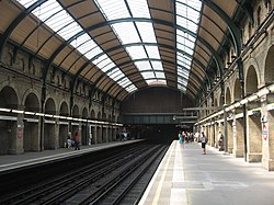
Fowler designed the Circle line platforms and the station was rebuilt by Clark. Chiltern Court, built above the station in the 1920s, is not included in the listing. [24] [25] 51°31′19.2″N0°9′25.2″W / 51.522000°N 0.157000°W / 51.522000; -0.157000 (Baker Street tube station)
Bank Bank underground station, Bank of England building entrance.JPG
I
Central, Northern, Waterloo & City1898The station has an entrance via the Grade I listed Bank of England main building and a redundant entrance within the Grade I listed church of St Mary Woolnoth. [26] [27] [28] 51°30′48.6″N0°5′19.5″W / 51.513500°N 0.088750°W / 51.513500; -0.088750 (Bank–Monument station)
Balham Balham Underground Station - geograph.org.uk - 662533.jpg
II
Northern 1926 Charles Holden Typical of Holden's designs for the stations on the Northern line extension. [29] [30] [31] 51°26′33.7″N0°9′7.2″W / 51.442694°N 0.152000°W / 51.442694; -0.152000 (Balham tube station)
Barking Barking station building2.JPG
II
District, Hammersmith & City1851, rebuilt in 1961 HH Powell Rebuilt after the Second World War on bridge over the railway lines. [32] [33] 51°32′21.5″N0°4′54.1″E / 51.539306°N 0.081694°E / 51.539306; 0.081694 (Barkingside tube station)
Barkingside Barkingside tube station 01, July 2013.jpg
II
Central 1903 William Burgess Built by the GER, the Central line extension took over the station in 1948. Listing covers the largely unaltered building on the platform. [34] [35] [36] 51°35′5.3″N0°5′19.0″E / 51.584806°N 0.088611°E / 51.584806; 0.088611 (Barkingside tube station)
Barons Court Barons Court Underground Station, Gliddon Road W14 - geograph.org.uk - 1288221.jpg
II
District, Piccadilly1905 Harry Wharton Ford with Leslie Green Built for the Piccadilly line extension, many original features still exist. [37] [11] [38] 51°29′26.2″N0°12′49.0″W / 51.490611°N 0.213611°W / 51.490611; -0.213611 (Barons Court tube station)
Belsize Park Belsize Park Tube Station.jpg
II
Northern1907 Leslie Green A typical Green design unusually with a small forecourt. [39] [40] [41] 51°33′1.1″N0°9′51.8″W / 51.550306°N 0.164389°W / 51.550306; -0.164389 (Belsize Park tube station)
Boston Manor Boston Manor stn building.JPG
II
Piccadilly1883, rebuilt 1933–34 Charles Holden 
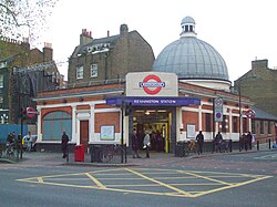
Original District Railway platforms remain, the station buildings were rebuilt by Holden for the Piccadilly line extension. A tower holds an enamelled London Underground roundel on glazed ceramic tiles. [42] [43] [44] 51°29′44.9″N0°19′30″W / 51.495806°N 0.32500°W / 51.495806; -0.32500 (Boston Manor tube station)
Bounds Green Bounds Green Underground Station - geograph.org.uk - 1064942.jpg
II
Piccadilly1932 Charles Holloway James with Charles Holden A Holden Sudbury box style station with several unique features. [45] [46] [47] 51°36′24.8″N0°7′27.1″W / 51.606889°N 0.124194°W / 51.606889; -0.124194 (Bounds Green tube station)
Bow Road Bow Road Station, Bow Road - geograph.org.uk - 433873.jpg
II
District, Hammersmith & City1902Design attributed to C A Brereton, Whitechapel and Bow Railway Engineer. [45] [48] [49] 51°31′38″N0°1′29″W / 51.52722°N 0.02472°W / 51.52722; -0.02472 (Bow Road tube station)
Brent Cross Brent Cross stn building.JPG
II
Northern1923 Stanley Heaps [50] [51] 51°34′36.1″N0°12′49.0″W / 51.576694°N 0.213611°W / 51.576694; -0.213611 (Brent Cross tube station)
Caledonian Road Caledonian Road stn building.JPG
II
Piccadilly1906 Leslie Green [52] [53] 51°32′53.9″N0°7′7″W / 51.548306°N 0.11861°W / 51.548306; -0.11861 (Caledonian Road tube station)
Chalk Farm Chalk Farm stn entrance.JPG
II
Northern1906–7 Leslie Green [54] [55] 51°32′39.1″N0°9′11.9″W / 51.544194°N 0.153306°W / 51.544194; -0.153306 (Chalk Farm tube station)
Chesham Chesham station building.jpg
II
Metropolitan1889A rural 19th century Metropolitan Railway station, complete with water tower and signal box, that survives largely unaltered. [56] [57] 51°42′18.7″N0°36′40.7″W / 51.705194°N 0.611306°W / 51.705194; -0.611306 (Chesham tube station)
Chiswick Park Chiswick Park station.jpg
II
District1933 Charles Holden [58] [59] 51°29′40.1″N0°16′4.1″W / 51.494472°N 0.267806°W / 51.494472; -0.267806 (Chiswick Park tube station)
Clapham Common Clapham Common Tube Station Exterior - Oct 2007.jpg
II
Northern1924 Charles Holden [60] [61] [62] 51°27′42″N0°8′16.8″W / 51.46167°N 0.138000°W / 51.46167; -0.138000 (Clapham Common tube station)
Clapham South ClaphamSouthTube.jpg
II
Northern1926 Charles Holden Entrance buildings were the first stations to be redesigned by Holden. Listing does not include the later block of flats above the station. [63] [64] [65] 51°27′10″N0°8′49.2″W / 51.45278°N 0.147000°W / 51.45278; -0.147000 (Clapham South tube station)
Cockfosters CockfostersExterior better.jpg
II
Piccadilly1933 Charles Holden Opened for the Piccadilly line extension. [66] [67] [68] 51°39′5.8″N0°8′55.7″W / 51.651611°N 0.148806°W / 51.651611; -0.148806 (Cockfosters tube station)
Colliers Wood Colliers Wood stn entrance.JPG
II
Northern1926 Charles Holden Opened for the Northern line extension. [69] [70] [71] 51°25′5.9″N0°10′40.8″W / 51.418306°N 0.178000°W / 51.418306; -0.178000 (Colliers Wood tube station)
Covent Garden Covent Garden stn building.JPG
II
Piccadilly1906 Leslie Green Office building above the station is not included in the listing. [72] [73] 51°30′46.8″N0°7′27.5″W / 51.513000°N 0.124306°W / 51.513000; -0.124306 (Covent Garden tube station)
Ealing Common Ealing Common stn building.JPG
II
District, Piccadilly1931 Charles Holden with Stanley Heaps [74] [75] 51°30′37″N0°17′17.1″W / 51.51028°N 0.288083°W / 51.51028; -0.288083 (Ealing Common tube station)
Earl's Court Earl's Court stn eastern entrance.JPG
II
District1876
1906
1937
John Wolfe Barry, Harry Wharton FordDistrict Railway train shed by Barry, expansions for the Piccadilly line by Ford, and a later entrance on Warwick Road [76] 51°31′12″N0°6′19.1″W / 51.52000°N 0.105306°W / 51.52000; -0.105306 (Earl's Court tube station)
Eastcote Eastcote tube station 1.jpg
II
Metropolitan, Piccadilly1936, opened 1939 Charles Holden Listing includes shops either side [77] [78] 51°34′36.1″N0°23′48.8″W / 51.576694°N 0.396889°W / 51.576694; -0.396889 (Eastcote tube station)
East Finchley East Finchley stn building.JPG
II
Northern1939 Charles Holden with Leonard Holcombe Bucknell Opened by the GNR, the Northern took over services in 1939. [79] [80] [81] 51°35′14″N0°9′54″W / 51.58722°N 0.16500°W / 51.58722; -0.16500 (East Finchley tube station)
East Ham East ham tube station london.jpg
II
District, Hammersmith & City1858
1902
[82] [83] 51°32′20.4″N0°3′5.8″E / 51.539000°N 0.051611°E / 51.539000; 0.051611 (East Ham tube station)
Farringdon Farringdon station original building 2012.JPG
II
Circle, Hammersmith & City, Metropolitan1865
1922
John Fowler,
Charles W Clark
Fowler built the original station before it was re-built by Clark [84] [85] 51°31′12″N0°6′19.1″W / 51.52000°N 0.105306°W / 51.52000; -0.105306 (Farringdon tube station)
Fulham Broadway Harry Ford's building at Fulham Broadway station.jpg
II
District1880
1905
Harry Wharton FordA unique station, [39] [86] [87] since 2003 access to the station has been via a nearby shopping arcade. 51°28′50.2″N0°11′40.9″W / 51.480611°N 0.194694°W / 51.480611; -0.194694 (Fulham Broadway tube station)
Gloucester Road Gloucester Road stn former Piccadilly building look north.JPG
II
Circle, District, Piccadilly1868
1906
Leslie Green Piccadilly line expansion by Green not now used by London Underground [88] [89] 51°29′40.9″N0°10′58.8″W / 51.494694°N 0.183000°W / 51.494694; -0.183000 (Gloucester Road tube station)
Great Portland Street Great Portland Street stn building east.JPG
II
Circle, Hammersmith & City, Metropolitanc.1912 – c.1930s Charles W Clark [90] [91] 51°31′25.7″N0°8′37.7″W / 51.523806°N 0.143806°W / 51.523806; -0.143806 (Great Portland Street tube station)
Green Park Green Park stn building.JPG
II
Piccadilly, Jubilee, Victoria1926The station, which opened in 1906, has entrances via the Grade II listed Devonshire House. [92] [93] 51°30′24.1″N0°8′34.1″W / 51.506694°N 0.142806°W / 51.506694; -0.142806 (Green Park tube station)
Harrow & Wealdstone Harrow & Wealdstone station (6394829949).jpg
II
Bakerloo1875Opened in 1837 by the London & Birmingham Railway, the London & North Western Railway later built the ticket office on platform 1. [94] [95] 51°35′33″N0°20′7.8″W / 51.59250°N 0.335500°W / 51.59250; -0.335500 (Harrow & Wealdstone tube station)
Harrow & Wealdstone main building.JPG
II
1912 Gerald Callcott Horsley The buildings on the north side of the station were built for the new electric services. [94] [96]
Hendon Central Hendon Central stn entrance.JPG
II
Northern1923 Stanley Heaps Part of a larger building not included in the listing [97] [98] 51°34′58.8″N0°13′33.6″W / 51.583000°N 0.226000°W / 51.583000; -0.226000 (Hendon Central tube station)
Holloway Road Holloway Road stn building02.jpg
II
Piccadilly1906 Leslie Green [99] [100] 51°33′11.2″N0°6′42.8″W / 51.553111°N 0.111889°W / 51.553111; -0.111889 (Holloway Road tube station)
Hounslow West Hounslow West stn building.JPG
II
Piccadilly1884
1931
1975
Charles Holden with Stanley Heaps Holden and Heaps are responsible for the 1931 ticket hall. Platforms were moved in 1975. [101] [102] 51°28′25″N0°23′8″W / 51.47361°N 0.38556°W / 51.47361; -0.38556 (Hounslow West tube station)
Kennington Kennington station building.JPG
II
Northern1890–1925 T Phillips Figgis [6] [103] 51°29′19″N0°6′20″W / 51.48861°N 0.10556°W / 51.48861; -0.10556 (Kennington tube station)
Kew Gardens Kew Gardens stn building.JPG
II
District 1869Station opened in 1869 by the London and South Western Railway, served by the District Railway since 1877. [104] [105] 51°28′37.6″N0°17′7.1″W / 51.477111°N 0.285306°W / 51.477111; -0.285306 (Kew Gardens station)
Kilburn Park KilburnPark Entrance.jpg
II
Bakerloo1914–15Probably by Stanley Heaps, after Leslie Green [106] [107] 51°32′6.4″N0°11′38.6″W / 51.535111°N 0.194056°W / 51.535111; -0.194056 (Kilburn Park tube station)
Leicester Square London Hippodrome 2011.jpg
II
Piccadilly, Northern1900The station, which opened in 1906, has an entrance via the Grade II listed Hippodrome. [108] [109] 51°30′41.04″N0°7′42.24″W / 51.5114000°N 0.1284000°W / 51.5114000; -0.1284000 (Leicester Square tube station)
Loughton Loughton tube station, July 2013.JPG
II
Central1939–40 John Murray Easton [110] [111] 51°34′58.8″N0°13′33.6″W / 51.583000°N 0.226000°W / 51.583000; -0.226000 (Loughton tube station)
Maida Vale Maida Vale Station - geograph.org.uk - 713154.jpg
II
Bakerloo1914–15Probably by Stanley Heaps, after Leslie Green [112] [113] 51°31′47.2″N0°11′8″W / 51.529778°N 0.18556°W / 51.529778; -0.18556 (Maida Vale tube station)
Moorgate Moorgate entrance Mfields.JPG
II
Circle, Hammersmith & City, Metropolitan, Northern1865, 1900 Thomas Phillips Figgis Two entrances are listed: Figgis designed the building in Moorgate [114] [115] 51°31′7″N0°5′19″W / 51.51861°N 0.08861°W / 51.51861; -0.08861 (Moorgate tube station)
Moorgate Underground Station, Moorgate - geograph.org.uk - 1073342.jpg
II*
1924–27 Edwin Lutyens The grade II* Lutyens house had a station entrance in Finsbury Circus [116] [117]
Mornington Crescent Mornington Crescent stn building.JPG
II
Northern1907 Leslie Green [118] [119] 51°32′3.8″N0°8′19″W / 51.534389°N 0.13861°W / 51.534389; -0.13861 (Mornington Crescent tube station)
North Ealing North Ealing stn building.JPG
II
Piccadilly1899
1903
Built 1899 by the District Railway, opened 1903 [120] [121] 51°29′57.8″N0°18′51.1″W / 51.499389°N 0.314194°W / 51.499389; -0.314194 (North Ealing tube station)
Northfields Northfields station building.JPG
II
Piccadilly1932 Charles Holden with Stanley Heaps [122] [123] 51°31′3″N0°17′19″W / 51.51750°N 0.28861°W / 51.51750; -0.28861 (Northfields tube station)
Notting Hill Gate Notting Hill Gate Tube Station.jpg
II
Circle, District, Central1868 John Fowler Train shed over the District and Circle line platforms [124] [125] 51°30′32.4″N0°11′49.2″W / 51.509000°N 0.197000°W / 51.509000; -0.197000 (Notting Hill Gate tube station)
Oakwood Oakwood tube station better.jpg
II*
Piccadilly1932–34 Charles Holden and Charles Holloway James [126] [127] 51°38′51″N0°7′54.1″W / 51.64750°N 0.131694°W / 51.64750; -0.131694 (Oakwood tube station)
Osterley Osterley station building2.JPG
II
Piccadilly1934 Stanley Heaps and Charles Holden [128] [129] 51°28′53″N0°21′7.92″W / 51.48139°N 0.3522000°W / 51.48139; -0.3522000 (Osterley tube station)
Oxford Circus Oxford Circus tube station - Central Line Entrance.jpg
II
Bakerloo, Central, Victoria 1900, upper storey before 1908 Harry Bell Measures, Delissa JosephCentral line entrance built by Measures, with the upper storey by Joseph [130] [131] 51°30′54.7″N0°8′29.8″W / 51.515194°N 0.141611°W / 51.515194; -0.141611 (Oxford Circus tube station)
Oxford Circus stn Bakerloo building.jpg 1906 Leslie Green Green designed the Bakerloo line entrance. Office building above is not included in the listing. [131] [132]
Paddington (Praed Street) Paddington subsurface station building.jpg
II
District, Circle1866–68 1915 John Fowler,
Charles W Clark
Fowler built the original Praed Street station before the street building was re-built by Clark [133] [134] 51°30′56″N0°10′32″W / 51.51556°N 0.17556°W / 51.51556; -0.17556 (Paddington station)
Park Royal Park Royal stn building.JPG
II
Piccadilly1935–36Welch and Lander, inspired by Holden
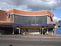
A replacement for the previous 1903 station 600 metres (660 yd) to the north, this station opened in 1931 and the current building was completed in 1936. Listing covers the station buildings and adjoining flats and shops. [135] [136] [137] 51°31′36.8″N0°17′3.1″W / 51.526889°N 0.284194°W / 51.526889; -0.284194 (Park Royal station)
Perivale Perivale station building.JPG
II
CentralDesigned 1938 completed 1947 Brian Lewis and Frederick Francis Charles Curtis A Great Western Railway halt rebuilt for the Central line extension. [138] [139] [140] 51°32′11.8″N0°19′23.9″W / 51.536611°N 0.323306°W / 51.536611; -0.323306 (Perivale station)
Piccadilly Circus Piccadilly Circus ticket hall.JPG
II
Bakerloo, Piccadilly1906/7, 1925–8 Charles Holden Underground concourse and subways designed by Holden, rebuilt 1925–8. Original Green access buildings demolished in 1990. [141] [142] [143] 51°30′36.4″N0°8′2.4″W / 51.510111°N 0.134000°W / 51.510111; -0.134000 (Piccadilly Circus station)
Rayner's Lane Rayners Lane stn building.JPG
II
Metropolitan, Piccadilly1938 Charles Holden and Reginald Uren Opened in 1906 by the Metropolitan Railway, the Piccadilly line was extended in 1933. Listing includes station with shops and platforms. [141] [144] [145] 51°34′31.1″N0°22′17.0″W / 51.575306°N 0.371389°W / 51.575306; -0.371389 (Rayner's Lane station)
Redbridge Redbridge stn buildingCollard.JPG
II
CentralDesigned 1935–38, opened 1947 Charles Holden One of Holden's last designs, the unopened tunnels were used as an aircraft component factory during World War II and the design was altered due to post-war austerity measures. [146] [147] [148] 51°34′32.6″N0°2′41.6″E / 51.575722°N 0.044889°E / 51.575722; 0.044889 (Redbridge station)
Ruislip Ruislip station - geograph.org.uk 2475091.jpg
II
Metropolitan, Piccadilly1904, modified 1928Opened in 1904 by the Metropolitan Railway, the Piccadilly line was extended in 1933. A largely unaltered Metropolitan Railway country station. [149] [150] [151] 51°34′17.0″N0°25′16.0″W / 51.571389°N 0.421111°W / 51.571389; -0.421111 (Ruislip station)
Russell Square Russell Square Underground.jpg
II
Piccadilly1906 Leslie Green Lower levels largely unaltered. [152] [153] [154] 51°31′23.2″N0°7′27.8″W / 51.523111°N 0.124389°W / 51.523111; -0.124389 (Russell Square station)
South Kensington South Kensington Tube Station - geograph.org.uk - 7170.jpg
II
Circle, District, Piccadilly1867–68, substantially altered 1907. John Fowler, altered by George Sherrin Sherrin designed the Edwardian shopping arcade, listing includes the subway to the museums. [155] [156] [157] 51°29′38.8″N0°10′25.7″W / 51.494111°N 0.173806°W / 51.494111; -0.173806 (South Kensington station)
South Wimbledon South Wimbledon stn entrance.JPG
II
Northern1926 Charles Holden Built out of Portland stone, with a curved facade on a corner site, for the Northern line extension to Morden. [158] [159] [160] 51°24′56″N0°11′27.6″W / 51.41556°N 0.191000°W / 51.41556; -0.191000 (South Wimbledon station)
Southgate Southgate station building2.JPG
II*
Piccadilly1933 Charles Holden Designed with a matching shopping arcade and bus station, retains many original features. [161] [162] [163] 51°37′57″N0°7′41.0″W / 51.63250°N 0.128056°W / 51.63250; -0.128056 (Southgate station)
St James's Park Broadway entrance to St. James's Park LU station.jpg
I
Circle, District1927–9 Charles Holden 55 Broadway, the headquarters of the UERL and incorporating St James Park station, was rebuilt by Holden. [164] [165] [166] 51°29′57.8″N0°8′3.8″W / 51.499389°N 0.134389°W / 51.499389; -0.134389 (St James's Park station)
St John's Wood St Johns Wood stn entrance.JPG
II
Jubilee1939 Stanley Heaps Includes a replica Harold Stabler tiles scheme. Apartment block built above in 1963 not included. [167] [168] [169] 51°32′4.9″N0°10′27.1″W / 51.534694°N 0.174194°W / 51.534694; -0.174194 (St John's Wood station)
Sudbury Hill Sudbury Hill stn building.JPG
II
Piccadilly1931 Charles Holden with Stanley Heaps Rebuilt for the Piccadilly line extension. [170] [171] [172] 51°33′2.9″N0°18′56.2″W / 51.550806°N 0.315611°W / 51.550806; -0.315611 (Sudbury Hill station)
Sudbury Town Sudbury Town stn main entrance.JPG
II*
Piccadilly1930–1 Charles Holden Rebuilt for the Piccadilly line extension, this was the prototype for Holden's 'Sudbury box' modernist designs for the Piccadilly line extensions. [173] [174] [175] 51°33′2.9″N0°18′56.2″W / 51.550806°N 0.315611°W / 51.550806; -0.315611 (Sudbury Town station)
Tooting Bec Tooting Bec Tube - geograph.org.uk - 411704.jpg
II
Northern1926 Charles Holden Built for the Northern line extension to Morden with two entrances constructed out of Portland stone. Original tiled decoration still present on sub-surface passages and platforms. [176] [177] [178] 51°26′9″N0°9′32.4″W / 51.43583°N 0.159000°W / 51.43583; -0.159000 (Tooting Bec station)
Tooting Broadway Statue of Edward VII outside Tooting Broadway Underground Station - geograph.org.uk - 1019794.jpg
II
Northern1926 Charles Holden Built for the Northern line extension to Morden with a curved facade made from Portland stone. Original tiled decoration still present on sub-surface passages and platforms. [176] [179] [180] 51°25′40″N0°10′4.8″W / 51.42778°N 0.168000°W / 51.42778; -0.168000 (Tooting Broadway station)
Turnpike Lane Turnpike Lane stn building.JPG
II
Piccadilly1932 Charles Holden Opened for the Piccadilly line extension. [181] [182] [183] 51°35′25.4″N0°6′10.1″W / 51.590389°N 0.102806°W / 51.590389; -0.102806 (Turnpike Lane station)
Uxbridge Uxbridge tube station front entrance 2009.jpg
II
Metropolitan, Piccadilly1938 Charles Holden with Leonard Holcombe Bucknell A concave station frontage and shops with a red brick facade. Platforms covered by concrete arches with sloped clerestory windows. [184] [185] 51°32′45.2″N0°28′41.9″W / 51.545889°N 0.478306°W / 51.545889; -0.478306 (Uxbridge tube station)
Watford Watford station exterior - geograph.org.uk - 464764.jpg
II
Metropolitanc.1925 Charles W Clark Brick built in domestic style to set the tone for the local Metro-land development [186] [187] 51°39′27″N0°25′3″W / 51.65750°N 0.41750°W / 51.65750; -0.41750 (Watford tube station)
West Acton West Acton stn building.JPG
II
Central1930s Brian Lewis Built by the Great Western Railway for the Central line extension. The concrete ticket hall, faced in brick with a full-height window on the front back, is on a bridge over the two platforms. [188] [189] 51°31′5.16″N0°16′50.9″W / 51.5181000°N 0.280806°W / 51.5181000; -0.280806 (West Acton tube station)
West Brompton WestBrompton1.jpg
II
District1869 John Fowler Best preserved example of a District Railway station. [190] [191] 51°29′11.8″N0°11′44.5″W / 51.486611°N 0.195694°W / 51.486611; -0.195694 (West Brompton tube station)
Willesden Green Willesdengreenstation.jpg
II
Jubilee 1879
1925
Charles W Clark Street buildings were re-built by Clark for the Metropolitan Railway with his cream terracotta facade. Services currently provided by the Jubilee line. [192] [193] 51°32′57.1″N0°13′18.1″W / 51.549194°N 0.221694°W / 51.549194; -0.221694 (Willesden Green tube station)
Wood Green Wood Green tube station - geograph.org.uk - 1281743.jpg
II
Piccadilly1932 Charles Holden Holden was constrained at Wood Green by the limited size of the corner site, and therefore used a different design than his other Piccadilly line stations of the early 1930s. [194] [195] 51°35′49.2″N0°6′36″W / 51.597000°N 0.11000°W / 51.597000; -0.11000 (Wood Green tube station)

See also

Map all coordinates using: OpenStreetMap

Related Research Articles

<span class="mw-page-title-main">London Underground</span> Rapid transit system in London, England

The London Underground is a rapid transit system serving Greater London and some parts of the adjacent home counties of Buckinghamshire, Essex and Hertfordshire in England.

<span class="mw-page-title-main">Central line (London Underground)</span> London Underground line

The Central line is a London Underground line that runs through central London, from Epping, Essex, in the north-east to Ealing Broadway and West Ruislip in west London. Printed in red on the Tube map, the line serves 49 stations over 46 miles (74 km), making it the longest line on the Underground. It is one of only two lines on the Underground network to cross the Greater London boundary, the other being the Metropolitan line. One of London's deep-level railways, Central line trains are smaller than those on British main lines.

<span class="mw-page-title-main">Listed building</span> Protected historic structure in the United Kingdom

In the United Kingdom, a listed building is a structure of particular architectural and/or historic interest deserving of special protection. Such buildings are placed on one of the four statutory lists maintained by Historic England in England, Historic Environment Scotland in Scotland, Cadw in Wales, and the Northern Ireland Environment Agency in Northern Ireland. These have classifications that differ between: England and Wales, Scotland and Northern Ireland. The term has also been used in the Republic of Ireland, where buildings are protected under the Planning and Development Act 2000, although the statutory term in Ireland is "protected structure".

<span class="mw-page-title-main">Covent Garden tube station</span> London Underground station

Covent Garden is a London Underground station serving Covent Garden and the surrounding area in the West End of London. It is on the Piccadilly line between Leicester Square and Holborn stations and is in Travelcard Zone 1. The station is at the corner of Long Acre and James Street and the street-level concourse is a Grade II listed building.

<span class="mw-page-title-main">Russell Square tube station</span> London Underground station

Russell Square is a London Underground station opposite Russell Square on Bernard Street, Bloomsbury, in the London Borough of Camden. The station is on the Piccadilly line, between Holborn and King's Cross St Pancras and is in Travelcard Zone 1.

<span class="mw-page-title-main">Mole Valley</span> Non-metropolitan district in England

Mole Valley is a local government district in Surrey, England. Its council is based in Dorking, and the district's other town is Leatherhead. The largest villages are Ashtead, Fetcham and Great Bookham, in the northern third of the district.

<span class="mw-page-title-main">Easton, Dorset</span> Human settlement in England

Easton is a village on the Isle of Portland in Dorset, England. The village is situated at Tophill, within the centre of the island. As with the rest of Portland's villages and settlements, Easton, including the settlements Reforne and Straits, has been designated as a conservation area, as it is a place of special architectural and historic interest. Easton, Wakeham and Reforne were designated pre-1974.

<span class="mw-page-title-main">Leslie Green</span> English architect

Leslie William Green was an English architect. He is best known for his design of iconic stations constructed on the London Underground railway system in central London during the first decade of the 20th century, with distinctive oxblood red faïence blocks including pillars and semi-circular first-floor windows, and patterned tiled interiors done in the Modern Style.

<span class="mw-page-title-main">Ewell</span> Town in Surrey, England

Ewell is a town in the Borough of Epsom and Ewell in Surrey, England. It is approximately 12 miles (19 km) south of central London and 2 miles (3.2 km) northeast of Epsom. In the 2011 Census, the town had a population of 34,872. The majority of which (73%) is in the ABC1 social class, except the Ruxley Ward that is C2DE.

<span class="mw-page-title-main">Charles Walter Clark</span>

Charles Walter Clark (1885–1972) was an architect who worked for the Metropolitan Railway from 1911 to 1933 and was responsible for designing 25 stations, five of which are listed buildings today.

<span class="mw-page-title-main">Signal boxes that are listed buildings in England</span>

A number of signal boxes in England are on the Statutory List of Buildings of Special Architectural or Historic Interest. Signal boxes house the signalman and equipment that control the railway points and signals. Originally, railway signals were controlled from a hut on a platform at junctions. In the 1850s, a raised building with a glazed upper storey containing levers controlling points and signals was developed after John Saxby obtained a patent in 1856 for a mechanical system of interlocking the points and signals. Over half of the signalboxes before 1923 were built by private signalling contractors, the largest being Saxby & Farmer; Stevens & Sons, McKenzie & Holland, the Railway Signal Co., Dutton & Co and Evans, and O'Donnell & Co. Some railway companies had a standard signalbox design, such as the London & North Western Railway, whereas others, such as the Great Eastern Railway had many different designs.

<span class="mw-page-title-main">Bass Maltings, Sleaford</span> Sleaford, North Kesteven, Lincolnshire, England

The Bass Maltings in Sleaford, England are a large group of eight disused malt houses originally owned by the Bass Brewery of Burton upon Trent. Constructed between 1901 and 1907 to Herbert A. Couchman's design, the maltings are the largest group of malt houses in England; they have been designated Grade II* on the National Heritage List for England, recognising them as "particularly important ... of more than special interest."

References

Notes

  1. "Heritage Library: Underground: Line". Urban Design. Transport for London. Archived from the original on 23 May 2013.
  2. "Protecting, conserving and providing access to the historic environment in England". Department for Digital, Culture, Media and Sport. 27 February 2013. Retrieved 7 May 2013.
  3. Ovenden 2013, pp. 11, 18–19.
  4. Ovenden 2013, pp. 26, 28.
  5. Ovenden 2013, p. 35.
  6. 1 2 Historic England. "Details from listed building database (1385635)". National Heritage List for England . Retrieved 3 April 2015.
  7. 1 2 Ovenden 2013, p. 38.
  8. Ovenden 2013, pp. 60–61, 70.
  9. "Heritage Library: Underground: Architect". Urban Design. Transport for London. Archived from the original on 16 August 2012.
  10. Ovenden 2013, pp. 41, 63.
  11. 1 2 Historic England. "Details from listed building database (1358562)". National Heritage List for England . Retrieved 3 April 2015.
  12. Ovenden 2013, pp. 150–152.
  13. Ovenden 2013, p. 146.
  14. "Underground Journeys: Charles Holden's designs for London Transport" (PDF). V&A RIBA architecture partnership. n.d. Archived from the original (PDF) on 14 March 2012. Retrieved 15 April 2013.
  15. Leboff 1994, p. 6.
  16. Historic England. "Details from listed building database (1263471)". National Heritage List for England . Retrieved 3 April 2015.
  17. "Acton Town". Urban Design. Transport for London. Archived from the original on 16 August 2012.
  18. "Aldgate East". Urban Design. Transport for London. Archived from the original on 16 August 2012.
  19. Historic England. "Details from listed building database (1065733)". National Heritage List for England . Retrieved 3 April 2015.
  20. Historic England. "Details from listed building database (1401034)". National Heritage List for England . Retrieved 3 April 2015.
  21. Leboff 1994, p. 12.
  22. Historic England. "Details from listed building database (1358981)". National Heritage List for England . Retrieved 3 April 2015.
  23. "Arnos Grove". Urban Design. Transport for London. Archived from the original on 16 August 2012.
  24. Historic England. "Details from listed building database (1239815)". National Heritage List for England . Retrieved 3 April 2015.
  25. "Baker Street". Urban Design. Transport for London. Archived from the original on 9 January 2013.
  26. "Bank". Urban Design. Transport for London. Archived from the original on 16 August 2012.
  27. Historic England. "Details from listed building database (1079134)". National Heritage List for England . Retrieved 3 April 2015.
  28. Historic England. "Church of St Mary Woolnoth (1064620)". National Heritage List for England . Retrieved 3 April 2015.
  29. Leboff 1994, p. 16.
  30. Historic England. "Details from listed building database (1225887)". National Heritage List for England . Retrieved 3 April 2015.
  31. "Balham". Urban Design. Transport for London. Archived from the original on 16 August 2012.
  32. Historic England. "Details from listed building database (1242678)". National Heritage List for England . Retrieved 3 April 2015.
  33. "Barking". Urban Design. Transport for London. Archived from the original on 16 August 2012.
  34. Leboff 1994, p. 18.
  35. Historic England. "Details from listed building database (1081012)". National Heritage List for England . Retrieved 3 April 2015.
  36. "Barkingside". Urban Design. Transport for London. Archived from the original on 16 August 2012.
  37. Leboff 1994, p. 20.
  38. "Barons Court". Urban Design. Transport for London. Archived from the original on 16 August 2012.
  39. 1 2 Leboff 1994, p. 21.
  40. Historic England. "Details from listed building database (1401089)". National Heritage List for England . Retrieved 3 April 2015.
  41. "Belsize Park". Urban Design. Transport for London. Archived from the original on 30 August 2012.
  42. Leboff 1994, p. 23.
  43. Historic England. "Details from listed building database (1063901)". National Heritage List for England . Retrieved 3 April 2015.
  44. "Boston Manor". Urban Design. Transport for London. Archived from the original on 16 August 2012.
  45. 1 2 Leboff 1994, p. 24.
  46. Historic England. "Details from listed building database (1393641)". National Heritage List for England . Retrieved 3 April 2015.
  47. "Bounds Green". Urban Design. Transport for London. Archived from the original on 16 August 2012.
  48. Historic England. "Details from listed building database (1357787)". National Heritage List for England . Retrieved 3 April 2015.
  49. "Bow Road". Urban Design. Transport for London. Archived from the original on 16 August 2012.
  50. Historic England. "Details from listed building database (1401123)". National Heritage List for England . Retrieved 3 April 2015.
  51. "Brent Cross". Urban Design. Transport for London. Archived from the original on 16 August 2012.
  52. Historic England. "Details from listed building database (1401086)". National Heritage List for England . Retrieved 3 April 2015.
  53. "Caledonian Road". Urban Design. Transport for London. Archived from the original on 16 August 2012.
  54. Historic England. "Details from listed building database (1401028)". National Heritage List for England . Retrieved 3 April 2015.
  55. "Chalk Farm". Urban Design. Transport for London. Archived from the original on 16 August 2012.
  56. Historic England. "Details from listed building database (1401704)". National Heritage List for England . Retrieved 3 April 2015.
  57. "Chesham". Urban Design. Transport for London. Archived from the original on 16 August 2012.
  58. Historic England. "Details from listed building database (1358798)". National Heritage List for England . Retrieved 3 April 2015.
  59. "Chiswick Park". Urban Design. Transport for London. Archived from the original on 16 August 2012.
  60. Leboff 1994, pp. 35–36.
  61. Historic England. "Details from listed building database (1065005)". National Heritage List for England . Retrieved 3 April 2015.
  62. "Clapham Common". Urban Design. Transport for London. Archived from the original on 16 August 2012.
  63. Leboff 1994, p. 36.
  64. Historic England. "Details from listed building database (1266140)". National Heritage List for England . Retrieved 3 April 2015.
  65. "Clapham South". Urban Design. Transport for London. Archived from the original on 16 August 2012.
  66. Leboff 1994, pp. 36–37.
  67. Historic England. "Details from listed building database (1358718)". National Heritage List for England . Retrieved 3 April 2015.
  68. "Cockfosters". Urban Design. Transport for London. Archived from the original on 25 May 2013.
  69. Leboff 1994, p. 38.
  70. Historic England. "Details from listed building database (1080925)". National Heritage List for England . Retrieved 3 April 2015.
  71. "Colliers Wood". Urban Design. Transport for London. Archived from the original on 16 August 2012.
  72. Historic England. "Details from listed building database (1401025)". National Heritage List for England . Retrieved 3 April 2015.
  73. "Covent Garden". Urban Design. Transport for London. Archived from the original on 16 August 2012.
  74. Historic England. "Details from listed building database (1249986)". National Heritage List for England . Retrieved 3 April 2015.
  75. "Ealing Common". Urban Design. Transport for London. Archived from the original on 7 May 2013.
  76. "Earl's Court". Urban Design. Transport for London. Archived from the original on 16 August 2012.
  77. Historic England. "Details from listed building database (1357435)". National Heritage List for England . Retrieved 3 April 2015.
  78. "Eastcote". Urban Design. Transport for London. Archived from the original on 16 August 2012.
  79. Leboff 1994, pp. 44–45.
  80. Historic England. "Details from listed building database (1359150)". National Heritage List for England . Retrieved 3 April 2015.
  81. "East Finchley". Urban Design. Transport for London. Archived from the original on 16 August 2012.
  82. Historic England. "Details from listed building database (1245066)". National Heritage List for England . Retrieved 3 April 2015.
  83. "East Ham". Urban Design. Transport for London. Archived from the original on 16 August 2012.
  84. Historic England. "Details from listed building database (1298047)". National Heritage List for England . Retrieved 3 April 2015.
  85. "Farringdon". Urban Design. Transport for London. Archived from the original on 16 August 2012.
  86. Historic England. "Details from listed building database (1358569)". National Heritage List for England . Retrieved 3 April 2015.
  87. "Fulham Broadway". Urban Design. Transport for London. Archived from the original on 16 August 2012.
  88. Historic England. "Details from listed building database (1080658)". National Heritage List for England . Retrieved 3 April 2015.
  89. "Gloucester Road". Urban Design. Transport for London. Archived from the original on 16 August 2012.
  90. Historic England. "Details from listed building database (1213650)". National Heritage List for England . Retrieved 3 April 2015.
  91. "Great Portland Street". Urban Design. Transport for London. Archived from the original on 16 August 2012.
  92. "Green Park". Urban Design. Transport for London. Archived from the original on 16 August 2012.
  93. Historic England. "Details from listed building database (1226746)". National Heritage List for England . Retrieved 3 April 2015.
  94. 1 2 "Harrow & Wealdstone". Urban Design. Transport for London. Archived from the original on 16 August 2012.
  95. Historic England. "Details from listed building database (1253986)". National Heritage List for England . Retrieved 3 April 2015.
  96. Historic England. "Details from listed building database (1253982)". National Heritage List for England . Retrieved 3 April 2015.
  97. Historic England. "Details from listed building database (1401082)". National Heritage List for England . Retrieved 3 April 2015.
  98. "Hendon Central". Urban Design. Transport for London. Archived from the original on 16 August 2012.
  99. Historic England. "Details from listed building database (1195635)". National Heritage List for England . Retrieved 3 April 2015.
  100. "Holloway Road". Urban Design. Transport for London. Archived from the original on 16 August 2012.
  101. Historic England. "Details from listed building database (1241237)". National Heritage List for England . Retrieved 3 April 2015.
  102. "Hounslow West". Urban Design. Transport for London. Archived from the original on 6 June 2013.
  103. "Kennington". Urban Design. Transport for London. Archived from the original on 16 August 2012.
  104. Historic England. "Details from listed building database (1031878)". National Heritage List for England . Retrieved 3 April 2015.
  105. "Kew Gardens". Urban Design. Transport for London. Archived from the original on 16 August 2012.
  106. Historic England. "Details from listed building database (1078871)". National Heritage List for England . Retrieved 3 April 2015.
  107. "Kilburn Park". Urban Design. Transport for London. Archived from the original on 16 August 2012.
  108. Historic England. "Details from listed building database (1066287)". National Heritage List for England . Retrieved 3 April 2015.
  109. "Leicester Square". Urban Design. Transport for London. Archived from the original on 9 August 2012.
  110. Historic England. "Details from listed building database (1141221)". National Heritage List for England . Retrieved 3 April 2015.
  111. "Loughton". Urban Design. Transport for London. Archived from the original on 16 August 2012.
  112. Historic England. "Details from listed building database (1066834)". National Heritage List for England . Retrieved 3 April 2015.
  113. "Maida Vale". Urban Design. Transport for London. Archived from the original on 5 November 2012.
  114. Historic England. "Details from listed building database (1359213)". National Heritage List for England . Retrieved 3 April 2015.
  115. "Moorgate". Urban Design. Transport for London. Archived from the original on 16 August 2012.
  116. "Moorgate (Nos. 94–100 Finsbury Circus)". Urban Design. Transport for London. Archived from the original on 16 August 2012.
  117. Historic England. "Details from listed building database (1064691)". National Heritage List for England . Retrieved 3 April 2015.
  118. Historic England. "Details from listed building database (1378713)". National Heritage List for England . Retrieved 3 April 2015.
  119. "Mornington Crescent". Urban Design. Transport for London. Archived from the original on 16 August 2012.
  120. Historic England. "Details from listed building database (1390751)". National Heritage List for England . Retrieved 3 April 2015.
  121. "North Ealing". Urban Design. Transport for London. Archived from the original on 16 August 2012.
  122. Historic England. "Details from listed building database (1263487)". National Heritage List for England . Retrieved 3 April 2015.
  123. "Northfields". Urban Design. Transport for London. Archived from the original on 16 August 2012.
  124. Historic England. "Details from listed building database (1225688)". National Heritage List for England . Retrieved 3 April 2015.
  125. "Notting Hill Gate". Urban Design. Transport for London. Archived from the original on 16 August 2012.
  126. Historic England. "Details from listed building database (1078930)". National Heritage List for England . Retrieved 3 April 2015.
  127. "Oakwood". Urban Design. Transport for London. Archived from the original on 16 August 2012.
  128. Historic England. "Details from listed building database (1240806)". National Heritage List for England . Retrieved 3 April 2015.
  129. "Osterley". Urban Design. Transport for London. Archived from the original on 24 May 2013.
  130. Historic England. "Details from listed building database (1400976)". National Heritage List for England . Retrieved 3 April 2015.
  131. 1 2 "Oxford Circus". Urban Design. Transport for London. Archived from the original on 16 August 2012.
  132. Historic England. "Details from listed building database (1401022)". National Heritage List for England . Retrieved 3 April 2015.
  133. Historic England. "Details from listed building database (1392020)". National Heritage List for England . Retrieved 3 April 2015.
  134. "Paddington". Urban Design. Transport for London. Archived from the original on 16 August 2012.
  135. Leboff 1994, p. 107.
  136. Historic England. "Details from listed building database (1079328)". National Heritage List for England . Retrieved 3 April 2015.
  137. "Park Royal". Urban Design. Transport for London. Archived from the original on 23 May 2013.
  138. Leboff 1994, pp. 108–9.
  139. Historic England. "Details from listed building database (1400747)". National Heritage List for England . Retrieved 3 April 2015.
  140. "Perivale". Urban Design. Transport for London. Archived from the original on 16 August 2012.
  141. 1 2 Leboff 1994, p. 109.
  142. Historic England. "Details from listed building database (1226877)". National Heritage List for England . Retrieved 3 April 2015.
  143. "Piccadilly Circus". Urban Design. Transport for London. Archived from the original on 16 August 2012.
  144. Historic England. "Details from listed building database (1261430)". National Heritage List for England . Retrieved 3 April 2015.
  145. "Rayner's Lane". Urban Design. Transport for London. Archived from the original on 16 August 2012.
  146. Leboff 1994, pp. 113–114.
  147. Historic England. "Details from listed building database (1401101)". National Heritage List for England . Retrieved 3 April 2015.
  148. "Redbridge". Urban Design. Transport for London. Archived from the original on 16 August 2012.
  149. Leboff 1994, pp. 116.
  150. Historic England. "Details from listed building database (1380983)". National Heritage List for England . Retrieved 3 April 2015.
  151. "Ruislip". Urban Design. Transport for London. Archived from the original on 16 August 2012.
  152. Leboff 1994, p. 118.
  153. Historic England. "Details from listed building database (1401730)". National Heritage List for England . Retrieved 3 April 2015.
  154. "Russell Square". Urban Design. Transport for London. Archived from the original on 16 August 2012.
  155. Leboff 1994, pp. 124–5.
  156. Historic England. "Details from listed building database (1392067)". National Heritage List for England . Retrieved 3 April 2015.
  157. "South Kensington". Urban Design. Transport for London. Archived from the original on 16 August 2012.
  158. Leboff 1994, pp. 126–7.
  159. Historic England. "Details from listed building database (1358037)". National Heritage List for England . Retrieved 3 April 2015.
  160. "South Wimbledon". Urban Design. Transport for London. Archived from the original on 16 August 2012.
  161. Leboff 1994, pp. 127–8.
  162. Historic England. "Details from listed building database (1188692)". National Heritage List for England . Retrieved 3 April 2015.
  163. "Southgate". Urban Design. Transport for London. Archived from the original on 12 January 2013.
  164. Leboff 1994, p. 128.
  165. Historic England. "Details from listed building database (1219790)". National Heritage List for England . Retrieved 3 April 2015.
  166. "St James's Park". Urban Design. Transport for London. Archived from the original on 16 August 2012.
  167. Leboff 1994, pp. 128–129.
  168. Historic England. "Details from listed building database (1401096)". National Heritage List for England . Retrieved 3 April 2015.
  169. "St John's Wood". Urban Design. Transport for London. Archived from the original on 16 August 2012.
  170. Leboff 1994, p. 132.
  171. Historic England. "Details from listed building database (1254171)". National Heritage List for England . Retrieved 3 April 2015.
  172. "Sudbury Hill". Urban Design. Transport for London. Archived from the original on 16 August 2012.
  173. Leboff 1994, pp. 132–133.
  174. Historic England. "Details from listed building database (1294594)". National Heritage List for England . Retrieved 3 April 2015.
  175. "Sudbury Town". Urban Design. Transport for London. Archived from the original on 16 August 2012.
  176. 1 2 Leboff 1994, p. 136.
  177. Historic England. "Details from listed building database (1065477)". National Heritage List for England . Retrieved 3 April 2015.
  178. "Tooting Bec". Urban Design. Transport for London. Archived from the original on 16 August 2012.
  179. Historic England. "Details from listed building database (1065478)". National Heritage List for England . Retrieved 3 April 2015.
  180. "Tooting Broadway". Urban Design. Transport for London. Archived from the original on 16 August 2012.
  181. Leboff 1994, p. 140.
  182. Historic England. "Details from listed building database (1263624)". National Heritage List for England . Retrieved 3 April 2015.
  183. "Turnpike Lane". Urban Design. Transport for London. Archived from the original on 16 August 2012.
  184. Historic England. "Details from listed building database (1358405)". National Heritage List for England . Retrieved 3 April 2015.
  185. "Uxbridge". Urban Design. Transport for London. Archived from the original on 16 August 2012.
  186. Historic England. "Details from listed building database (1393965)". National Heritage List for England . Retrieved 3 April 2015.
  187. "Watford". Urban Design. Transport for London. Archived from the original on 5 November 2012.
  188. Historic England. "Details from listed building database (1400997)". National Heritage List for England . Retrieved 3 April 2015.
  189. "West Acton". Urban Design. Transport for London. Archived from the original on 27 May 2013.
  190. Historic England. "Details from listed building database (1385365)". National Heritage List for England . Retrieved 3 April 2015.
  191. "West Brompton". Urban Design. Transport for London. Archived from the original on 16 August 2012.
  192. Historic England. "Details from listed building database (1391808)". National Heritage List for England . Retrieved 3 April 2015.
  193. "Willesden Green". Urban Design. Transport for London. Archived from the original on 16 August 2012.
  194. Historic England. "Details from listed building database (1401120)". National Heritage List for England . Retrieved 3 April 2015.
  195. "Wood Green". Urban Design. Transport for London. Archived from the original on 16 August 2012.

Books