
Coconino County is a county located in the north-central part of the U.S. state of Arizona. Its population was 134,421 at the 2010 census. The county seat is Flagstaff. The county takes its name from Cohonino, a name applied to the Havasupai. It is the second-largest county by area in the contiguous United States, behind San Bernardino County, California, with its 18,661 sq mi (48,300 km2), or 16.4% of Arizona's total area, making it larger than each of the nine smallest states.

Clarks Hill is a census-designated place (CDP) in McCormick County, South Carolina, United States. The population was 376 at the 2000 census.
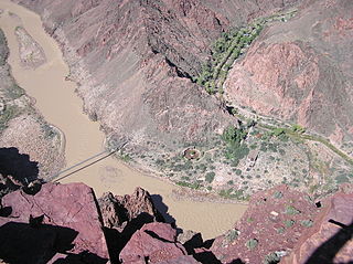
The South Kaibab Trail is a hiking trail in Grand Canyon National Park, located in the U.S. state of Arizona. Unlike the Bright Angel Trail which also begins at the south rim of the Grand Canyon and leads to the Colorado River, the South Kaibab Trail follows a ridge out to Skeleton Point allowing for 360-degree views of the canyon.
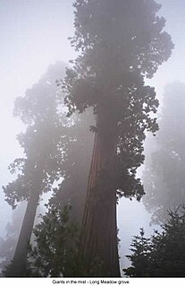
Sequoia National Forest is located in the southern Sierra Nevada mountains of California. The U.S. National Forest is named for the majestic Giant Sequoia trees which populate 38 distinct groves within the boundaries of the forest.

The Arizona Strip is the part of Arizona lying north of the Colorado River. The difficulty of crossing the Grand Canyon causes this region to have more physical and cultural connections with southern Utah and Nevada than with the rest of Arizona. The largest settlements in the Strip are Colorado City, Fredonia, and Beaver Dam, with its surrounding communities of Scenic, Littlefield and Desert Springs.

The Coconino Plateau is found south of the Grand Canyon and north-northwest of Flagstaff, in northern Arizona of the Southwestern United States.

The Vermilion Cliffs are the second "step" up in the five-step Grand Staircase of the Colorado Plateau, in northern Arizona and southern Utah. They extend west from near Page, Arizona, for a considerable distance, in both Arizona and Utah.

The Arizona National Scenic Trail is a National Scenic Trail from Mexico to Utah that traverses the whole north–south length of the U.S. state of Arizona. The trail begins at the Coronado National Memorial near the US–Mexico border and moves north through parts of the Huachuca, Santa Rita, and Rincon Mountains. The trail continues through the Santa Catalina north of Tucson and the Mazatzal Mountains before ascending the Mogollon Rim north of Payson, eventually leading to the higher elevations of Northern Arizona and the San Francisco Peaks. The trail then continues across the Coconino Plateau and in and out of the Grand Canyon. The Arizona Trail terminates near the Arizona–Utah border in the Kaibab Plateau region. The 800-mile (1,300 km) long Arizona Trail was completed on December 16, 2011. The trail is designed as a primitive trail for hiking, equestrians, mountain biking, and even cross country skiing, showcasing the wide variety of mountain ranges and ecosystems of Arizona.

A fire lookout tower, fire tower or lookout tower, provides housing and protection for a person known as a "fire lookout" whose duty it is to search for wildfires in the wilderness. The fire lookout tower is a small building, usually located on the summit of a mountain or other high vantage point, in order to maximize the viewing distance and range, known as view shed. From this vantage point the fire lookout can see smoke that may develop, determine the location by using a device known as an Osborne Fire Finder, and call fire suppression personnel to the fire. Lookouts also report weather changes and plot the location of lightning strikes during storms. The location of the strike is monitored for a period of days after in case of ignition.
The North Kaibab Trail is a hiking trail in the North Rim side of the Grand Canyon, in Grand Canyon National Park, located in the U.S. state of Arizona.

The Tonto Trail is a hiking trail on the South Rim of the Grand Canyon in Grand Canyon National Park, located in the U.S. state of Arizona.

The River Trail is a hiking trail in Grand Canyon National Park, located in the U.S. state of Arizona. This trail connects the end of the Bright Angel Trail with Phantom Ranch and the South Kaibab Trail.

Sycamore Canyon is the second largest canyon in the Arizona redrock country, after Oak Creek Canyon. The 21-mile (34 km) long scenic canyon reaches a maximum width of about 7 miles (11 km). It is in North Central Arizona bordering and below the Mogollon Rim, and is located west and northwest of Sedona in Yavapai and Coconino counties.
The Grand Cañon Forest Reserve was established by the General Land Office in Arizona on February 20, 1893 with 1,851,250 acres (7,491.7 km2). It was renamed Grand Canyon on August 8, 1906 and transferred to the U.S. Forest Service becoming a National Forest on March 4, 1907. On July 1, 1908 the entire forest was divided between Coconino National Forest and the newly established Kaibab National Forest, while other areas were returned to public lands, and the name was discontinued.
Sault-au-Cochon is an unorganized territory in the Capitale-Nationale region of Quebec, Canada, in the La Côte-de-Beaupré Regional County Municipality. It is an unpopulated and undeveloped stretch of shoreline along the Saint Lawrence River that encompasses the promontory from Cape Tourmente to Petite-Rivière-Saint-François.

Located directly downstream of the Little Colorado River confluence with the Colorado River, the Tanner Graben, in the Grand Canyon, Arizona, USA is a prominence and cliffside rock formation below the East Rim. Tanner Graben is located riverside, on the Colorado River, on a north-northwest bank at Mile 68.5, and lies opposite Tanner Canyon. The Tanner Rapid, created by Tanner Creek lies at the riverside foot of the graben. The graben is a pronounced feature because of the black Cardenas Basalt that forms the middle section of the graben, presumably free of debris accumulation by its cliff face steepness, and winds, and airflow drainage that course through the Colorado River's canyons; unprotected side canyons of Cardenas Basalt show accumulations as a slope-forming geologic unit, with little showing of black basalt.
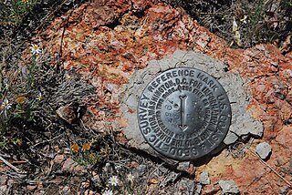
The Brow Monument is a monument listed in the National Register of Historic Places for Coconino County, Arizona, located in the Kaibab National Forest. The site contains one of the few remaining survey markers used by the expedition of John Wesley Powell in 1872 It is accessible via the Brow Monument Trail.

