
Buchanan is a town in Botetourt County, Virginia, United States. The population was 1,196 at the 2020 census. It is part of the Roanoke Metropolitan Statistical Area. It was the western terminus of the James River and Kanawha Canal when construction on the canal ended.

The James River and Kanawha Canal was a partially built canal in Virginia intended to facilitate shipments of passengers and freight by water between the western counties of Virginia and the coast. Ultimately its towpath became the roadbed for a rail line following the same course.
Taylorstown is a small community in Loudoun County, Virginia, built on the banks of Catoctin Creek and the surrounding hillside, about two miles (3 km) south of the Potomac River. First settled in 1734, it holds two of the oldest standing houses in Loudoun County, "Hunting Hill" and "Foxton Cottage", directly across the Catoctin Creek from each other.

Buildings, sites, districts, and objects in Virginia listed on the National Register of Historic Places:

James Breckinridge was a Virginia lawyer and politician and a member of the Breckinridge family. He served in the Virginia House of Delegates, as well as the U.S. House of Representatives. He also fought in the American Revolutionary War and served as a brigadier-general during the War of 1812.

Eagle Rock is a census-designated place (CDP) in Botetourt County, Virginia, United States, located along the James River between Iron Gate and Buchanan. It was first listed as a CDP in the 2020 census with a population of 209.
Abbs Valley is an unincorporated community and census-designated place (CDP) located in Tazewell County, Virginia. It was first listed as a CDP in the 2020 census with a population of 299.

This is a list of the National Register of Historic Places listings in Botetourt County, Virginia.

This is a list of the National Register of Historic Places listings in Frederick County, Virginia.

Fine Creek Mills Historic District encompasses a historic mill-centered community in Powhatan County, Virginia, United States. It was listed on the National Register of Historic Places in 2004.

Tuscarora Creek Historic District is a national historic district located near Martinsburg and Nollville, Berkeley County, West Virginia. It encompasses 31 contributing buildings and three contributing sites, related to the early settlement and economic development along the Tuscarora Creek. Notable buildings in the district include: Patterson's Mill (1765) and the miller's house, "Elm Dale," the Silber-Walters House, Huxley Hall, site of Patterson's New Mill and miller's house, Hibbard Mill, Tuscarora School, Providence Cemetery, the Mong House, Tuscarora Church (1802), James Noll Shop, Rumsey Mill site, and the poor house or "Mansion House" (1788).
Buchanan Historic District is a national historic district located at Buchanan, Botetourt County, Virginia. It encompasses 277 contributing buildings, 5 contributing sites, and 4 contributing structures in Buchanan and Pattonsburg on both sides of the James River. They include commercial, transportation-related, domestic, religious, and industrial resources associated with the community's development from the late-18th century through the late-20th century. Notable buildings include the Pattonsburg Mill (1838), Buchanan Presbyterian Church (1845), Trinity Episcopal Church (1842), Hotel Botetourt (1851), Sorrell House (1850), James Evans Mason Lodge (1884), Virginia Can Company complex (1903), "Oak Hill" (1840), Town Hall Municipal Building, Bank of Buchanan, Ransone's Drugstore, Buchanan Theatre (1919), and Buchanan High School (1928). The contributing sites include the James River & Kanawha Canal project site, Johnston-Boyd Cemetery (1835–1906), and Mountain View Cemetery (1854). The contributing structures include the Stone Arch Tunnel (1870s). Also located in the district is the separately listed Wilson Warehouse.
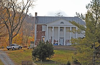
Lauderdale is a historic home located near Buchanan, Botetourt County, Virginia. Lauderdale takes its name from the eighteenth century owner of the property, James Lauderdale Sr. Lauderdale purchased 366 acres on Looney Mill Creek in 1749. By the early 1780s, he owned over a thousand acres in Botetourt County, and in 1785 he was listed as the owner of a dwelling and three other buildings. The home Lauderdale was built in 1790 by James Lauderdale Sr. Lauderdale Sr. settled in the area in 1730, when the region was still in the possession of the Indians. The mansion 'Lauderdale' was built near a spring, near which it is said that Lauderdale shot and killed an Indian during an attack on his home. The plantation consisted of 1200 acres, Lauderdale is one of the largest houses in Botetourt. There are thirty rooms within its walls. The high ceilings and hand carved woodwork of the immense hallway, library, and drawing room make it one of the handsomest houses is Virginia. The bricks on its walls were made by slaves on the place. In 1796, Lauderdale sold 444 acres, including his residence to Col. Henry Bowyer. Most references to Lauderdale incorrectly show the date of its construction as 1821, yet the Botetourt County Deed Book VI, page 36, clearly shows the subsequent owner of the mansion from Lauderdale's son, James Lauderdale Jr., a Col. Henry Bowyer, having purchased the home in 1796.

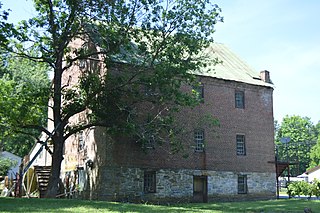
Breckinridge Mill, also known as Howell's Mill and Breckinridge Mill Complex, is a historic grist mill complex located near Fincastle, Botetourt County, Virginia. The mill was built about 1822, and is a 3+1⁄2-story, brick structure. The mill was converted to apartments in 1977. Associated with the mill are two contributing wood-frame, late 19th-century sheds. Also associated with the mill is the miller's or Howell house. It was built about 1900, and is a two-story, Queen Anne style frame structure with a T-plan and gabled roof. The mill was built for James Breckinridge (1763-1833) and replaced an earlier mill erected by him in 1804.
Nininger's Mill, also known as Tinker Mill, is a historic grist mill located near Daleville, Botetourt County, Virginia. The mill was built about 1847, and is a three-story, brick structure with a gable roof. Wood-frame additions added in the 20th century, are found on the north and east walls. Also on the property is a contributing simple one-story, wood-frame late 19th-century house. The mill was converted to a restaurant in 1980.
Varney's Falls Dam is a historic lock and dam structure located on the James River near Gilmore Mills, Botetourt County, Virginia. It was built in 1851, and is a massive limestone structure. The lock chamber measures 100 feet long between gate recesses, 15 feet wide, and approximately 21 feet from the top on the upriver end to ground level. Associated with the lock are the lock and dam abutment structures, the remaining towpaths, canal bed, berm bank, towpath culvert and remnants of a towpath bridge. The dam was destroyed in 1881, and the lock gates removed in 1885.

Phoenix Bridge is a historic metal trapezoidal Whipple truss railroad bridge spanning Craig Creek near Eagle Rock, Botetourt County, Virginia. It was built in 1887 by the Phoenix Bridge Company of Phoenixville, Pennsylvania. It consists of rolled wrought iron "Phoenix post" compression members and round and rectangular tension rods with pinned joints. It includes a cast panel embellished with anthemions and garlands, small urn-like finials, and quatrefoils and trefoils.

Bowyer-Holladay House, also known as the Lewis Holladay House, is a historic archaeological site located near Fincastle, Botetourt County, Virginia. The site is located in The Botetourt Center at Greenfield industrial park. The site consists of the ruins of an Early Republic/Federal Style two-story brick house with a limestone lined cellar in a rear-centered ell configuration. The house was part of the plantation complex commonly referred to as the "Holladay Place." In addition to the ruins of the main house, a log structure with an early timber and modern frame addition survives 25 feet north of the bulkhead entrance to the limestone cellar.
Whitaker's Mill Archeological Complex, also known as Burwell's Mill, is the site of an early colonial mill complex in York County near Williamsburg. Located on the historic King's Creek Plantation near Route 199 and Water Country Parkway, the site has industrial remains of millworks from the 17th and 18th centuries, as well as military encampment sites associated with the American Revolutionary War and the American Civil War.
The original Maggoty Gap was a wind gap in the Blue Ridge Mountains in the counties of Roanoke, Virginia and Franklin, Virginia. Over time, as roads were improved and relocated, the identified location of the gap moved with them. It is now mapped at a spot in Roanoke County.

