Lop Nur

Last updated

لوپنۇر 40°10′N90°35′E / 40.167°N 90.583°E / 40.167; 90.583

Nuclear weapons test base

Mushroom cloud of the first Chinese nuclear weapon test, Project 596, at Lop Nur in 1964. 1965-01 1964Nian Shou Ci Yuan Zi Dan Bao Zha 3.jpg
Mushroom cloud of the first Chinese nuclear weapon test, Project 596, at Lop Nur in 1964.

Lop Nur, situated in the arid Xinjiang region of China's far west, serves as an extensive military base. This location was selected for nuclear testing due to its desolate and isolated nature, devoid of any permanent inhabitants, though the broader Xinjiang region is home to the Uyghurs, a predominantly Muslim ethnic group that has historically faced widespread detentions and stringent security measures in Xinjiang conflict. The Uyghurs have persistently voiced concerns regarding the health risks posed by the towering mushroom clouds and the release of radioactive fallout. [21]

China established the Lop Nur Nuclear Test Base on 16 October 1959 with Soviet assistance in selection of the site, with its headquarters at Malan (马兰, Mǎlán), about 125 kilometres (78 mi) northwest of Qinggir. [2] The first Chinese nuclear bomb test, codenamed "Project 596", occurred at Lop Nur on 16 October 1964. China detonated its first hydrogen bomb on 17 June 1967. Until 1996, 45 nuclear tests were conducted. These nuclear tests were conducted by dropping bombs from aircraft, mounted on towers, launching missiles, detonating weapons underground and in the atmosphere. [22]

In 2009, Jun Takada, a Japanese scientist, published the results of his computer simulation which suggests – based on deaths from Soviet tests – that 190,000 people could have died in China from nuclear-related illnesses. [23] Enver Tohti, an exiled pro-Uyghur independence activist, claimed that cancer rates in the province of Xinjiang were 30 to 35% higher than the national average. [24] On 29 July 1996, China conducted its 45th and final nuclear test at Lop Nor, and issued a formal moratorium on nuclear testing the following day, although further subcritical tests were suspected. [25] In 2012, China announced plans to spend US$1 million to clean up the Malan nuclear base in Lop Nor to create a red tourism site. [26]

In December 2023, a report emerged indicating that China was making preparations to resume nuclear tests in a remote desert. Satellite imagery provided evidence of these preparations, revealing the presence of a drilling rig that had created a deep vertical shaft. This shaft was believed to be designed to contain the destructive power of radiation resulting from large nuclear explosions. [21]

Further analysis of the satellite images since 2017 also uncovered the development of new infrastructure at the site. This included the construction of new roads, power lines, an electrical substation, and a support area with multiple buildings. What was once a modest site with only a few buildings had transformed into a modern and sophisticated complex, complete with security fences. One of the new structures was a bunker that was fortified with earthen berms and lightning arresters, indicating its suitability for handling high explosives. Tests on miniaturization of missiles and warheads can also be possibly carried out at this site. However, the Chinese Foreign Ministry has dismissed the report and its "utterly irresponsible" claims. China has denied any nuclear testing plans on the site. [21]

Ecology

Lop Nur is home to the wild Bactrian camel, which is a separate species from the Bactrian camel. The camels have continued to breed naturally despite the nuclear testing. China signed the Comprehensive Nuclear-Test-Ban Treaty in 1996 but did not ratify it. [27] Subsequently, the camels were classified as an endangered species on the IUCN Red List. [28] Since the cessation of nuclear testing at Lop Nur, human incursions into the area have caused a decline in the camel population. [28] [29] [30] Wild Bactrian camels have been classified as critically endangered since 2002 [28] and approximately half of the 1400 remaining wild Bactrian camels live on the former Lop Nur test base, which has been designated the Lop Nur Wild Camel National Nature Reserve.

Transportation

A highway from Hami to Lop Nur (Xinjiang Provincial Highway 235) was completed in 2006. [31]

The Hami–Lop Nur Railway, which runs 374.83 kilometres (232.91 mi) north to Hami, along the same route, opened to freight operations in November 2012. The railway is used to transport potassium-rich salt mined at the lake to the Lanzhou–Xinjiang railway. [31]

It is also served by the Hotan–Ruoqiang railway, which loops around the south and west side of the Tarim Basin, part of the Taklimakan Desert railway loop, joined together with sections of the Golmud–Korla railway, Kashgar–Hotan railway, and Southern Xinjiang railway. [32]

Archaeological sites

Mask from second millennium BCE EuropoidMaskLopNurChina2000-1000BCE.jpg
Mask from second millennium BCE

Given the extreme dryness and resulting thin population, remains of some buildings survived for a significant period of time. When ancient graves, some a few thousand years old, were opened the bodies were often found to be mummified and grave goods well preserved. The earliest sites are associated with an ancient people of Indo European origin.

Loulan

Loulan or Kroran was an ancient kingdom based around an important oasis city already known in the 2nd century BCE on the north-eastern edge of the Lop Desert.[ citation needed ] It was renamed Shanshan after Chinese took control of the kingdom in 1st century BCE. It was abandoned some time in the seventh century. Its location was discovered by Sven Hedin in 1899, who excavated some houses and found a wooden Kharosthi tablet and many Chinese manuscripts from the Jin dynasty (266–420). [14] Aurel Stein also excavated at the site in the beginning of the 20th century, while Chinese archaeologists explored the area in the latter part of the 20th century. A mummy called the Beauty of Loulan was found at a cemetery site on the bank of Töwän River.

Xiaohe Cemetery

The Xiaohe Cemetery is located to the west of Lop Nur. This Bronze Age burial site is an oblong sand dune, from which more than thirty well preserved mummies have been excavated. The entire Xiaohe Cemetery contains about 330 tombs, about 160 of which have been violated by grave robbers. [33]

A local hunter guided the Swedish explorer and archeologist Folke Bergman to the site in 1934. An excavation project by the Xinjiang Cultural Relics and Archaeology Institute began in October 2003. A total of 167 tombs have been dug up since the end of 2002 and excavations have revealed hundreds of smaller tombs built in layers, as well as other precious artifacts. In 2006, a valuable archeological finding was uncovered: a boat-shaped coffin wrapped in ox hide, containing the mummified body of a young woman. [34]

Qäwrighul

In 1979, some of the earliest of the Tarim mummies were discovered in burial sites at Qäwrighul (Gumugou), which is located to the west of Lop Nur, on the Könchi (Kongque) river. Forty-two graves, most of which dated from 2100 to 1500 BC, were found. There were two types of tomb at the site, belonging to two different time periods. The first type of burial featured shaft pit graves, some of which had poles at either end to mark east and west. Bodies were found extended, usually facing east, and sometimes were wrapped in wool weavings and wearing felt hats. Artifacts found included basketry, wheat grains, cattle and sheep/goat horns, bird bone necklaces and bracelets, nephrite beads, and fragments of copper (or bronze), although no pottery was discovered.

The second type of burial, from a later period, also consisted of shaft pit graves, surrounded by seven concentric circles of poles. Six male graves were found, in which the bodies were extended on their backs, and facing towards the east. Few artifacts were found, except for some traces of copper, or bronze. [35]

Miran

Miran is located to the south-west of Lop Nur. Buddhist monasteries were excavated here, and murals and sculptures showed artistic influences from India and Central Asia, with some showing influences from as far as Rome.

See also

Related Research Articles

<span class="mw-page-title-main">Taklamakan Desert</span> Desert in Xinjiang, China

The Taklamakan Desert is a desert in Southwestern Xinjiang in Northwest China. Located inside the Tarim Basin in Southern Xinjiang, it is bounded by the Kunlun Mountains to the south, the Pamir Mountains to the west, the Tian Shan range to the north, and the Gobi Desert to the east.

<span class="mw-page-title-main">Sven Hedin</span> Swedish geographer, explorer, photographer, and illustrator (1865–1952)

Sven Anders Hedin, KNO1kl RVO, was a Swedish geographer, topographer, explorer, photographer, travel writer and illustrator of his own works. During four expeditions to Central Asia, he made the Transhimalaya known in the West and located sources of the Brahmaputra, Indus and Sutlej Rivers. He also mapped lake Lop Nur, and the remains of cities, grave sites and the Great Wall of China in the deserts of the Tarim Basin. In his book Från pol till pol, Hedin describes a journey through Asia and Europe between the late 1880s and the early 1900s. While traveling, Hedin visited Turkey, the Caucasus, Tehran, Iraq, lands of the Kyrgyz people and the Russian Far East, India, China and Japan. The posthumous publication of his Central Asia Atlas marked the conclusion of his life's work.

<span class="mw-page-title-main">Tarim River</span> River in Xinjiang, China

The Tarim River, known in Sanskrit as the Śītā, is an endorheic river in Xinjiang, China. It is the principal river of the Tarim Basin, a desert region of Central Asia between the Tian Shan and Kunlun Mountains. The river historically terminated at Lop Nur, but today reaches no further than Taitema Lake before drying out.

<span class="mw-page-title-main">Tarim Basin</span> Endorheic basin in Xinjiang, China

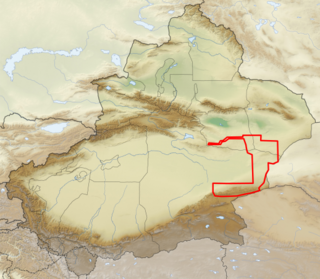
The Tarim Basin is an endorheic basin in Xinjiang, Northwestern China occupying an area of about 888,000 km2 (343,000 sq mi) and one of the largest basins in Northwest China. Located in China's Xinjiang region, it is sometimes used synonymously to refer to the southern half of the province, that is, Southern Xinjiang or Nanjiang, as opposed to the northern half of the province known as Dzungaria or Beijiang. Its northern boundary is the Tian Shan mountain range and its southern boundary is the Kunlun Mountains on the edge of the Tibetan Plateau. The Taklamakan Desert dominates much of the basin. The historical Uyghur name for the Tarim Basin is Altishahr, which means 'six cities' in Uyghur. The region was also called Little Bukhara or Little Bukharia.

<span class="mw-page-title-main">Lop Desert</span> Desert in China

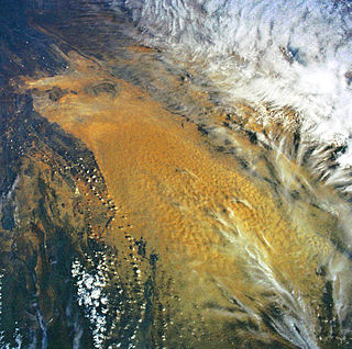
The Lop Desert, or the Lop Depression, is a desert extending from Korla eastwards along the foot of the Kuruk-tagh to the former terminal Tarim Basin in the Xinjiang Uyghur Autonomous Region of China. It is an almost perfectly flat expanse with no topographic relief. Lake Bosten in the northwest lies at an altitude of 1,030 to 1,040 m, while the Lop Nur in the southeast is only 250 m lower.

<span class="mw-page-title-main">Shanshan</span> Former kingdom in central Asia

Shanshan was a kingdom located at the north-eastern end of the Taklamakan Desert near the great, but now mostly dry, salt lake known as Lop Nur.

<span class="mw-page-title-main">Loulan Kingdom</span> Ancient kingdom in modern China

Loulan, also called Krorän or Kroraina, was an ancient kingdom based around an important oasis city along the Silk Road already known in the 2nd century BCE on the northeastern edge of the Lop Desert. The term Loulan is the Chinese transcription of the native name Krorän and is used to refer to the city near Lop Nur as well as the kingdom.

<span class="mw-page-title-main">Tarim mummies</span> Series of mummies discovered in the Tarim Basin

The Tarim mummies are a series of mummies discovered in the Tarim Basin in present-day Xinjiang, China, which date from 1800 BCE to the first centuries BCE, with a new group of individuals recently dated to between c. 2100 and 1700 BCE. The Tarim population to which the earliest mummies belonged was agropastoral, and they lived circa 2000 BCE in what was formerly a freshwater environment, which has now become desertified.

<span class="mw-page-title-main">Taitema Lake</span>

Taitema Lake is an endorheic lake in Ruoqiang County, Bayingolin Mongol Autonomous Prefecture, southeast of the Tarim Basin, Xinjiang Uyghur Autonomous Region, People's Republic of China. It is located in the northern part of Ruoqiang County, and is one of the three main depressions of that area, the other two being Karakoshun Lake (喀拉库顺湖) and Lop Nur.

<span class="mw-page-title-main">Tarim Basin deciduous forests and steppe</span> Ecoregion in Xinjiang, China

The Tarim Basin deciduous forests and steppe is a temperate broadleaf and mixed forests ecoregion in the Xinjiang Uyghur Autonomous Region of western China. The ecoregion includes deciduous riparian forests and steppes sustained by the region's rivers in an otherwise arid region.

<span class="mw-page-title-main">Miran (Xinjiang)</span> Ancient city in Xinjiang

Miran or Mirān is a former city that existed until the 1st millennium, on the southern rim of the Taklamakan Desert in Xinjiang, China. Located at an oasis, where the Lop Nur desert meets the Altun Shan mountains, Miran was once a major point on the Silk Road.

Charklik or Charkhlik is an archeology site named after the town of Charkhlik (Qakilik), in Ruoqiang (Qakilik) County, Xinjiang Uyghur Autonomous Region of the People's Republic of China. Together with the nearby Miran site, they correspond to two ancient capitals of Shanshan, Wuni and Yixun. However, it is as yet unclear which site correspond to which capital.

<span class="mw-page-title-main">Gobi Desert</span> Desert in East Asia

The Gobi Desert is a large, cold desert and grassland region in northern China and southern Mongolia and is the sixth largest desert in the world. The name of the desert comes from the Mongolian word Gobi, used to refer to all of the waterless regions in the Mongolian Plateau, while in Chinese Gobi is used to refer to rocky, semi-deserts such as the Gobi itself rather than sandy deserts.

<span class="mw-page-title-main">Xiaohe Cemetery</span> Cemetery in Ruoqiang County, China

The Xiaohe Cemetery, also known as Ördek's Necropolis, is a Bronze Age site located in the west of Lop Nur, in Xinjiang, Western China. It contains about 330 tombs, about 160 of which were looted by grave robbers before archaeological research could be carried out.

<span class="mw-page-title-main">Beauty of Loulan</span> Mummified woman found in China

The Beauty of Loulan (楼兰美女), also Beauty of Krorän or Loulan Beauty is the preserved dead body of a woman who lived around 1800 BCE in the Xinjiang region of China. Due ot her excellent state of conservation, she is one of the most famous Tarim mummies.

John Neville Hare was a British explorer, author, and conservationist, known for campaigning for the preservation of the Wild Bactrian camel.

<span class="mw-page-title-main">Lop Nur Wild Camel National Nature Reserve</span> Nature reserve in Xinjiang Province, China

Lop Nur Wild Camel National Nature Reserve protects one of the three remaining habitats of the Wild Bactrian camel, a critically endangered species. The reserve stretches around the north, east, and south of Lop Nur, a dry lake in a desert known as the "Sea of Death", and one of the most arid regions in the world. The reserve was established in 1986 by Xinjiang Province, and has been modified over the years. The reserve is under pressure from new roads in the area, development of mining interests, and illegal hunting.

The Sino-Swedish Expedition was a bilateral Chinese-Swedish expedition, led by Sven Hedin, which carried out scientific research in north and northwest China, 1927–1935.

<span class="mw-page-title-main">Princess of Xiaohe</span> 3,800 year old mummy found in China

The Princess of Xiaohe or Little River Princess was found in 2003 at Xiaohe Cemetery in Lop Nur, Xinjiang. She is one of the Tarim mummies, and is known as M11 for the tomb she was found in. Buried approximately 3,800 years ago, she has European and Siberian genes and has white skin and red hair; however, her maternal ancestors may have been of Asian origin, like many other mummies in this complex. She is unusually well preserved, with clothes, hair, and eyelashes still intact.

<span class="mw-page-title-main">Karakoshun Lake</span>

Karakoshun Lake was an inland lake located in the Bayingolin Mongol Autonomous Prefecture, Xinjiang Uyghur Autonomous Region, China, which is now dry.

References

  1. Barber, Elizabeth (2000). The Mummies of Urümchi. W. W. Norton & Company. p. 125. Two groups have laid claim to nor, the second half of Lop Nor. Nor is Mongol for 'lake' and occurs as part of many lake names in Xinjiang and other parts of Central Asia, while nur is Uyghur for 'bright' (as in the white of the salt flats). Mongol probably wins this one. But lop is opaque in both languages and in Chinese too, a fact suggesting that the name goes back to a time before Turks, Mongols, or Chinese had entered the territory.
  2. 1 2 "Lop Nor Nuclear Weapons Test Base". nti. Retrieved 3 August 2007.
  3. "Lop Nur, Xinjiang, China". Earth Observatory. 19 June 2011.PD-icon.svg This article incorporates text from this source, which is in the public domain .
  4. 三问哈罗铁路. Sina Weibo . 《新疆哈密广播电视报》. 6 December 2012.
  5. Fa-hsien; Legge, James (1886). A record of Buddhistic kingdoms; being an account by the Chinese monk Fâ-Hien of his travels in India and Ceylon, A.D. 399-414, in search of the Buddhist books of discipline. Translated and annotated with a Corean recension of the Chinese text. Robarts – University of Toronto. Oxford Clarendon Press.
  6. Dent, J. M. (1908), "Chapter 36: Of the Town of Lop Of the Desert in its Vicinity – And of the strange Noises heard by those who pass over the latter", The travels of Marco Polo the Venetian, pp. 99–101
  7. "The Wandering Lake". NASA. Archived from the original on 16 April 2002. Retrieved 3 August 2007.PD-icon.svg This article incorporates text from this source, which is in the public domain .
  8. Strindberg, August. "En svensk karta över Lop-nor och Tarimbäckenet" (in Swedish). Archived from the original on 28 September 2007. Retrieved 16 August 2007.
  9. Zizhi Tongjian Original text: 蒲昌海,一名泑澤,亦名鹽澤,亦名輔日海,亦名穿蘭,亦名臨海,在沙州西南。Translation; Puchang Hai, another name is You Ze, also called Yan ze, Furi Hai, Chuan Lan, and Lin Hai. It is located to the south-west of Shazhou (Dunhuang).
  10. Shiji Original text: 而樓蘭、姑師邑有城郭,臨鹽澤。Translation: The cities of Loulan and Gushi have walls; they lie near to Yan Ze.
  11. 1 2 Hanshu Original text: 蒲昌海,一名鹽澤者也,去玉門、陽關三百餘里,廣袤三四百里。其水亭居,冬夏不增減,皆以為潛行地下,南出於積石,為中國河雲. Translation: Puchang Hai, also named Yan Ze, lies over 300 li from the Yumen and Yangguan Pass, and is 300 to 400 li in length and breadth. Its waters are stagnant, and do not increase or decrease during the winter or summer. It is generally believed that the water flows hidden underground, emerges south at Jishi, and becomes the Chinese River (meaning Yellow River).
  12. Lou Yulie, ed. (17 September 2015). Buddhism. Brill. p. 270. ISBN   9789047427971.
  13. 1 2 3 Zhao Songqiao and Xia Xuncheng (1984). "Evolution of the Lop Desert and the Lop Nor". The Geographical Journal. 150 (3): 311–321. doi:10.2307/634326. JSTOR   634326.
  14. 1 2 Makiko Onishi and Asanobu Kitamoto. "Hedin, the Man Who Solved the Mystery of the Wandering Lake: Lop Nor and Lou-lan". Digital Silk Road.
  15. Sven Hedin, The Wandering lake, 1940. The river was also called the Kum Darya (Sand River). The Gizi map of Xinjiang calls it the Konche, which is probably a mistake.
  16. Liang Chao (13 April 2004). "Quenching thirst in Tarim Basin". China Daily. Archived from the original on 10 May 2012.
  17. "Desert Intrudes upon Tarim Lake". china.org.cn. Retrieved 3 August 2007.
  18. "Tarim River Ecological Protection Suggested". china.org.cn. Retrieved 3 August 2007.
  19. "China Creates 'Man-made Oasis' Along Longest Inland River". China DevelopmentGateway. Xinhua News Agency. 15 September 2007.
  20. "Found Dead – Yu Chunshun, 48, Intrepid Chinese explorer". asiaweek.com. Retrieved 18 September 2007.
  21. 1 2 3 Broad, William J.; Buckley, Chris; Corum, Jonathan (20 December 2023). "China Quietly Rebuilds Secretive Base for Nuclear Tests". The New York Times. Retrieved 22 December 2023.
  22. Burrows, Andrew S.; Fieldhouse, Richard (1993). Nuclear Weapons Databook. Boulder: Westview Press. p. 380.
  23. Subhabrata Das (20 April 2009). "China's nuclear tests allegedly caused 190000 deaths". Digital Journal.
  24. Zeeya Merali (8 July 2009). "Did China's Nuclear Tests Kill Thousands and Doom Future Generations?". Scientific American. Retrieved 27 October 2012.
  25. Jeffrey Lewis (3 April 2009). "Subcritical Testing at Lop Nor". Arms Control Wonk. Archived from the original on 31 October 2012. Retrieved 31 October 2012.
  26. "China to open ex-atomic site to tourists". Beijing: United Press International. 17 October 2012. Retrieved 27 October 2012.
  27. Borger, Julian (16 April 2020). "China may have conducted low-level nuclear test, US report claims". The Guardian. ISSN   0261-3077 . Retrieved 23 April 2020.
  28. 1 2 3 Hare, J. (2008). "Camelus ferus". IUCN Red List of Threatened Species . 2008. doi: 10.2305/iucn.uk.2008.rlts.t63543a12689285.en .
  29. "'New' camel lives on salty water". BBC News. 6 February 2001.
  30. "Wild Camel". Wild Camel Protection Foundation.
  31. 1 2 China starts building railway into "sea of death" Archived 2012-02-29 at the Wayback Machine , gov.cn, Thursday, 4 March 2010
  32. Zhang, Kate (17 June 2022). "New railway completes 2,700km loop of Taklamakan Desert in move to integrate Xinjiang with rest of China". South China Morning Post.
  33. "Burial Site from the Bronze Age, Lop Nur, Xinjiang". www.china.org.cn. Retrieved 18 September 2007.
  34. "Silk Road Documentary Unearths Latest Findings". china.org.cn. Retrieved 18 September 2007.
  35. Kwang-tzuu Chen and Fredrik T. Hiebert (1995). "The Late Prehistory of Xinjiang in Relation to Its Neighbors". Journal of World Prehistory9 (2): 243–300.
Lop Nur
Basin of Lop Nur 90.25E, 40.10N, Desert of Lop, Kum Tagh and Astin Tagh.jpg
Satellite picture of the Basin of the former sea of Lop Nur; the concentric shorelines of the vanished lake are visible.
Pixel.png
China Xinjiang rel location map.svg
Red pog.svg
Lop Nur
Location of Lop Nur within Xinjiang
China edcp relief location map.jpg
Red pog.svg
Lop Nur
Lop Nur (China)