Louisville, Kansas

Last updated

Louisville, Kansas
Pottawatomie County Kansas Incorporated and Unincorporated areas Louisville Highlighted.svg
Location within Pottawatomie County and Kansas
Map of Pottawatomie Co, Ks, USA.png
Coordinates: 39°15′00″N96°18′52″W / 39.25000°N 96.31444°W / 39.25000; -96.31444 [1]
Country United States
State Kansas
County Pottawatomie
Founded1857
Incorporated 1870
Named for Louis Wilson and Louis Vieux
Area
[2]
  Total
0.50 sq mi (1.29 km2)
  Land0.50 sq mi (1.29 km2)
  Water0.00 sq mi (0.00 km2)
Elevation
[1]
1,011 ft (308 m)
Population
 (2020) [3]
  Total
131
  Density260/sq mi (100/km2)
Time zone UTC-6 (CST)
  Summer (DST) UTC-5 (CDT)
ZIP code
66450
Area code 785
FIPS code 20-42925
GNIS ID 2395771 [1]

Louisville is a city in Pottawatomie County, Kansas, United States. [1] As of the 2020 census, the population of the city was 131. [3]

Contents

History

Founded in 1857 by Robert Wilson as Rock Post. The area was once part of the Potawatomi Hunting grounds and a large majority of the settlers were either associated with the Pottawatomie Indian Reservation or commerce on the Oregon Trail. [4] Louisville was named for Robert Wilson's son, Louis, and for Louis Vieux, a successful businessman in the area. The town was a contender for county seat of Pottawatomie County but lost to St. George in 1861 and Westmoreland in 1882. [4]

On November 8, 1875, Louisville was struck by an earthquake. [4] In 1882, with the county seat in Westmoreland and the Union Pacific Railroad built through Wamego, the town's population swiftly declined.

Louis Vieux

Louis Vieux Sr. [5] was a prominent citizen of Louisville who operated a trail crossing across the Vermillion River. He was born in 1809 in Wisconsin to Angelique Roy, a Potawatomi woman, and Jacques Vieux, a Canadian-French trader. Vieux and his wife, Sha-Note, moved first to Cedar Bluffs, Iowa in 1832 until moving to Indianola, Kansas (northwest of Topeka along Soldier Creek) in 1846. Sha-Note died in 1857 and Vieux moved to the Vermillion River near present-day Louisville. Vieux began his trail crossing business and worked as a caller for the U.S. Government working the pay station in St. Mary's and he also served on the tribal council and made trips to Washington, D.C., on behalf of the Pottawatomies. Vieux also signed the treaty that split the Pottawatomies into two separate tribes-the Prairie Band and Citizen Potawatomi Nation. Vieux died in 1872 and left behind a 200-page will leaving half the town of Louisville, all of Belvue and other personal property to his wife and children.

Oregon Trail crossing

The Louis Vieux Elm Tree park, in 2009, located three miles east of Louisville. Louis Vieux Elm Tree Park.JPG
The Louis Vieux Elm Tree park, in 2009, located three miles east of Louisville.

About three miles east of Louisville was the Vermillion Crossing of the Oregon Trail operated by Louis Vieux. Vieux is buried in the Vieux Family Cemetery on top of a hill. Nearby, on the banks of the river, is a cholera cemetery from 1849, which is estimated to contain at least fifty graves, although only two stones—both native sandstones—remain. The Louis Vieux Elm Tree is across the river and is estimated to be over 300 years old. The tree had been afflicted with Dutch elm disease, a lightning strike and vandalism and efforts were taken to protect and shelter the tree's stump. In August 2011, the stump was destroyed by fire. [6] Near the tree are the graves of seven unknown soldiers.

Geography

Louisville is located between Wamego and Westmoreland on K-99.

According to the United States Census Bureau, the city has a total area of 0.49 square miles (1.27 km2), all of it land. [7]

Demographics

Historical population
CensusPop.Note
1860 135
1870 344154.8%
1880 43225.6%
1890 382−11.6%
1900 336−12.0%
1910 246−26.8%
1920 207−15.9%
1930 2279.7%
1940 188−17.2%
1950 1901.1%
1960 2047.4%
1970 2040.0%
1980 2071.5%
1990 2153.9%
2000 209−2.8%
2010 188−10.0%
2020 131−30.3%
U.S. Decennial Census

Louisville is part of the Manhattan, Kansas Metropolitan Statistical Area.

2020 census

The 2020 United States census counted 131 people, 57 households, and 25 families in Louisville. [8] [9] The population density was 262.5 per square mile (101.4/km2). There were 78 housing units at an average density of 156.3 per square mile (60.4/km2). [9] [10] The racial makeup was 96.95% (127) white or European American (96.95% non-Hispanic white), 0.0% (0) black or African-American, 0.0% (0) Native American or Alaska Native, 0.0% (0) Asian, 0.0% (0) Pacific Islander or Native Hawaiian, 0.0% (0) from other races, and 3.05% (4) from two or more races. [11] Hispanic or Latino of any race was 0.76% (1) of the population. [12]

Of the 57 households, 14.0% had children under the age of 18; 33.3% were married couples living together; 22.8% had a female householder with no spouse or partner present. 38.6% of households consisted of individuals and 14.0% had someone living alone who was 65 years of age or older. [9] The average household size was 1.8 and the average family size was 2.2. [13] The percent of those with a bachelor’s degree or higher was estimated to be 10.7% of the population. [14]

13.7% of the population was under the age of 18, 6.1% from 18 to 24, 27.5% from 25 to 44, 33.6% from 45 to 64, and 19.1% who were 65 years of age or older. The median age was 46.8 years. For every 100 females, there were 92.6 males. [9] For every 100 females ages 18 and older, there were 82.3 males. [9]

The 2016-2020 5-year American Community Survey estimates show that the median household income was $47,500 (with a margin of error of +/- $21,465) and the median family income was $55,909 (+/- $7,179). [15] Males had a median income of $21,534 (+/- $3,471) versus $34,375 (+/- $13,252) for females. The median income for those above 16 years old was $21,932 (+/- $7,089). [16] Approximately, 2.0% of families and 6.4% of the population were below the poverty line, including 28.6% of those under the age of 18 and 0.0% of those ages 65 or over. [17] [18]

2010 census

As of the census [19] of 2010, there were 188 people, 78 households, and 39 families residing in the city. The population density was 383.7 inhabitants per square mile (148.1/km2). There were 96 housing units at an average density of 195.9 per square mile (75.6/km2). The racial makeup of the city was 92.0% White, 1.1% Native American, 4.3% from other races, and 2.7% from two or more races. Hispanic or Latino of any race were 5.9% of the population.

There were 78 households, of which 29.5% had children under the age of 18 living with them, 38.5% were married couples living together, 10.3% had a female householder with no husband present, 1.3% had a male householder with no wife present, and 50.0% were non-families. 26.9% of all households were made up of individuals, and 10.2% had someone living alone who was 65 years of age or older. The average household size was 2.41 and the average family size was 3.18.

The median age in the city was 34.5 years. 22.9% of residents were under the age of 18; 11.7% were between the ages of 18 and 24; 28.7% were from 25 to 44; 26.1% were from 45 to 64; and 10.6% were 65 years of age or older. The gender makeup of the city was 51.1% male and 48.9% female.

2000 census

As of the census [20] of 2000, there were 209 people, 77 households, and 56 families residing in the city. The population density was 427.3 inhabitants per square mile (165.0/km2). There were 84 housing units at an average density of 171.7 per square mile (66.3/km2). The racial makeup of the city was 98.56% White, 0.48% from other races, and 0.96% from two or more races. Hispanic or Latino of any race were 1.44% of the population.

There were 77 households, out of which 37.7% had children under the age of 18 living with them, 54.5% were married couples living together, 18.2% had a female householder with no husband present, and 26.0% were non-families. 19.5% of all households were made up of individuals, and 7.8% had someone living alone who was 65 years of age or older. The average household size was 2.71 and the average family size was 3.09.

In the city, the population was spread out, with 29.2% under the age of 18, 8.1% from 18 to 24, 30.1% from 25 to 44, 20.1% from 45 to 64, and 12.4% who were 65 years of age or older. The median age was 35 years. For every 100 females, there were 95.3 males. For every 100 females age 18 and over, there were 97.3 males.

The median income for a household in the city was $35,568, and the median income for a family was $37,045. Males had a median income of $26,250 versus $18,472 for females. The per capita income for the city was $15,741. About 8.9% of families and 12.2% of the population were below the poverty line, including 24.5% of those under the age of eighteen and none of those 65 or over.

Education

The community is served by Wamego USD 320 public school district.

Related Research Articles

<span class="mw-page-title-main">Garnett, Kansas</span> City in Anderson County, Kansas

Garnett is a city in and the county seat of Anderson County, Kansas, United States. As of the 2020 census, the population of the city was 3,242.

<span class="mw-page-title-main">Isabel, Kansas</span> City in Kiowa County, Kansas

Isabel is a city in Barber County, Kansas, United States. As of the 2020 census, the population of the city was 68.

<span class="mw-page-title-main">Glasco, Kansas</span> City in Cloud County, Kansas

Glasco is a city in Cloud County, Kansas, United States. As of the 2020 census, the population of the city was 441.

<span class="mw-page-title-main">Arcadia, Kansas</span> City in Crawford County, Kansas

Arcadia is a city in northeast Crawford County, Kansas, United States. As of the 2020 census, the population of the city was 254.

<span class="mw-page-title-main">Denton, Kansas</span> City in Doniphan County, Kansas

Denton is a city in Doniphan County, Kansas, United States. As of the 2020 census, the population of the city was 130.

<span class="mw-page-title-main">Longton, Kansas</span> City in Elk County, Kansas

Longton is a city in Elk County, Kansas, United States, along the Elk River. As of the 2020 census, the population of the city was 288.

<span class="mw-page-title-main">Randall, Kansas</span> City in Jewell County, Kansas

Randall is a city in Jewell County, Kansas, United States. As of the 2020 census, the population of the city was 79.

<span class="mw-page-title-main">Allen, Kansas</span> City in Lyon County, Kansas

Allen is a city in Lyon County, Kansas, United States. As of the 2020 census, the population of the city was 160.

<span class="mw-page-title-main">Galesburg, Kansas</span> City in Neosho County, Kansas

Galesburg is a city in Neosho County, Kansas, United States. As of the 2020 census, the population of the city was 149.

<span class="mw-page-title-main">Ness City, Kansas</span> City in Ness County, Kansas

Ness City is a city in and the county seat of Ness County, Kansas, United States. As of the 2020 census, the population of the city was 1,329. Ness City is famous for its four-story Old Ness County Bank Building located downtown and nicknamed Skyscraper of the Plains.

<span class="mw-page-title-main">Ransom, Kansas</span> City in Ness County, Kansas, United States

Ransom is a city in Ness County, Kansas, United States. As of the 2020 census, the population of the city was 260.

<span class="mw-page-title-main">Belvue, Kansas</span> City in Pottawatomie County, Kansas

Belvue is a city in Pottawatomie County, Kansas, United States. As of the 2020 census, the population of the city was 177.

<span class="mw-page-title-main">Plevna, Kansas</span> City in Reno County, Kansas

Plevna is a city in Reno County, Kansas, United States. As of the 2020 census, the population of the city was 85.

<span class="mw-page-title-main">Belleville, Kansas</span> City in Republic County, Kansas

Belleville is a city in and the county seat of Republic County, Kansas, United States. As of the 2020 census, the population of the city was 2,007.

<span class="mw-page-title-main">Narka, Kansas</span> City in Republic County, Kansas

Narka is a city in Republic County, Kansas, United States. As of the 2020 census, the population of the city was 81.

<span class="mw-page-title-main">Alden, Kansas</span> City in Rice County, Kansas

Alden is a city in Rice County, Kansas, United States. As of the 2020 census, the population of the city was 122.

<span class="mw-page-title-main">Gaylord, Kansas</span> City in Smith County, Kansas

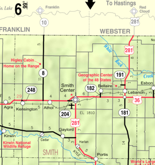
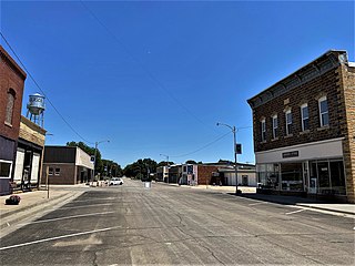
Gaylord is a city in Smith County, Kansas, United States. As of the 2020 census, the population of the city was 87.

<span class="mw-page-title-main">Argonia, Kansas</span> City in Sumner County, Kansas

Argonia is a city in Sumner County, Kansas, United States. As of the 2020 census, the population of the city was 456.

<span class="mw-page-title-main">New Albany, Kansas</span> City in Wilson County, Kansas

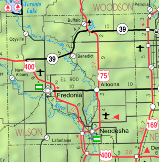
New Albany is a city in Wilson County, Kansas, United States. As of the 2020 census, the population of the city was 57.

References

  1. 1 2 3 4 U.S. Geological Survey Geographic Names Information System: Louisville, Kansas
  2. "2019 U.S. Gazetteer Files". United States Census Bureau. Retrieved July 24, 2020.
  3. 1 2 "Profile of Louisville, Kansas in 2020". United States Census Bureau. Archived from the original on May 26, 2022. Retrieved May 26, 2022.
  4. 1 2 3 Fitzgerald, Daniel. Faded Dreams: More Ghost Towns of Kansas. Lawrence: U of Kansas P, 1994, 29-33.
  5. VIEUX, Louis Sr., The Oregon Trail, Pottawatome County, KANSAS COLLECTION ARTICLES, http://www.kancoll.org/articles/otrail/ortrail5.htm
  6. "Arson claims historic elm's stump".
  7. "US Gazetteer files 2010". United States Census Bureau. Archived from the original on July 2, 2012. Retrieved July 6, 2012.
  8. "US Census Bureau, Table P16: HOUSEHOLD TYPE". data.census.gov. Retrieved January 3, 2024.
  9. 1 2 3 4 5 "US Census Bureau, Table DP1: PROFILE OF GENERAL POPULATION AND HOUSING CHARACTERISTICS". data.census.gov. Retrieved January 3, 2024.
  10. "Gazetteer Files". Census.gov. United States Census Bureau. Retrieved December 30, 2023.
  11. "US Census Bureau, Table P1: RACE". data.census.gov. Retrieved January 3, 2024.
  12. "US Census Bureau, Table P2: HISPANIC OR LATINO, AND NOT HISPANIC OR LATINO BY RACE". data.census.gov. Retrieved January 3, 2024.
  13. "US Census Bureau, Table S1101: HOUSEHOLDS AND FAMILIES". data.census.gov. Retrieved January 3, 2024.
  14. "US Census Bureau, Table S1501: EDUCATIONAL ATTAINMENT". data.census.gov. Retrieved January 3, 2024.
  15. "US Census Bureau, Table S1903: MEDIAN INCOME IN THE PAST 12 MONTHS (IN 2020 INFLATION-ADJUSTED DOLLARS)". data.census.gov. Retrieved January 3, 2024.
  16. "US Census Bureau, Table S2001: EARNINGS IN THE PAST 12 MONTHS (IN 2020 INFLATION-ADJUSTED DOLLARS)". data.census.gov. Retrieved January 3, 2024.
  17. "US Census Bureau, Table S1701: POVERTY STATUS IN THE PAST 12 MONTHS". data.census.gov. Retrieved January 3, 2024.
  18. "US Census Bureau, Table S1702: POVERTY STATUS IN THE PAST 12 MONTHS OF FAMILIES". data.census.gov. Retrieved January 3, 2024.
  19. "U.S. Census website". United States Census Bureau . Retrieved July 6, 2012.
  20. "U.S. Census website". United States Census Bureau . Retrieved January 31, 2008.

Further reading