
Kennebunk is a town in York County, Maine, United States. The population was 11,536 at the 2020 census. Kennebunk is home to several beaches, the Rachel Carson National Wildlife Refuge, the 1799 Kennebunk Inn, many historic shipbuilders' homes, the Brick Store Museum and the Nature Conservancy Kennebunk Plains, with 1,500 acres (6 km2) of nature trails and blueberry fields.

Blackacre State Nature Preserve is a 271-acre (110 ha) nature preserve and historic homestead in Louisville, Kentucky. The preserve features rolling fields, streams, forests, and a homestead dating back to the 18th century. For visitors, the preserve features several farm animals including horses, goats, and cows, hiking trails, and a visitor center in the 1844-built Presley Tyler home. Since 1981, it has been used by the Jefferson County Public Schools as the site of a continuing environmental education program. About 10,000 students visit the outdoor classroom each year.
The Nelson Family Farm is a historic farm property on Shackley Hill Road in Livermore, Maine. It is locally distinctive for the farmhouse, built about 1830 out of rough-split granite after a fire destroyed the Nelson's first homestead. The farm listed on the National Register of Historic Places in 1992.
The Boutell-Hathorn House is a historic house and farm located at 280 Woburn Street in Wilmington, Massachusetts.

The Christopher C. Walker House and Farm is a historic farmstead in the far western part of the U.S. state of Ohio. Located southwest of the village of New Madison along State Route 121, it is composed of five buildings and one other structure spread out over an area of nearly 160 acres (65 ha).

Henderson Hall Historic District is a National Register of Historic Places (NRHP)-listed historic district in Boaz, Wood County, West Virginia. The primary contributing property is Henderson Hall, a home in the Italianate style from the first half of the 19th century. Other residences at the site are a tenant house from the end of the 19th century, and "Woodhaven", the 1877 home of Henry Clay Henderson. Additional structures include a smokehouse, two corn cribs, a carriage barn that also served as a schoolhouse, a scale house used for storing agricultural equipment, and two barns. Also included within the district are the 19th-century Henderson family cemetery, a wall, a mounting block, and three mounds associated with the pre-Columbian Adena culture.

The Walker–Klinner Farm is a historic 1,600-acre (650 ha) farm and historic district near Maplesville, Chilton County, Alabama. The present boundaries of the farm were established during the mid-1850s. The two-and-a-half-story Eastlake-style farmhouse was built in 1890. Other contributing structures include the front yard fence (1927), tool shed (1900), chicken house (1900), corn crib (1890), overseer's house (1930), four tenant houses, shed (1900), three barns, water pump (1900), chicken coop (1900), cemetery, store, and a dogtrot house. There are also 15 noncontributing structures on the property. The farm is significant for its intact mid-19th century farm boundaries and for being maintained as a farm for more than 135 years at the time of nomination to the National Register. It was added to the National Register of Historic Places on October 15, 1987.

The Alfred Historic District is an historic district encompassing the historic village center of Alfred, Maine. The roughly Y-shaped district radiates from the junction of Oak Street with Kennebunk, Waterboro, and Saco Roads, and is characterized by high-quality 19th-century wood-frame buildings. The district was added to the National Register of Historic Places in 1983.
The Eastman Hill Rural Historic District is a historic district encompassing a rural landscape consisting of three 19th-century farmsteads near the village of Center Lovell, Maine. It covers 251 acres (102 ha) of the upper elevations of Eastman Hill, and is bisected by Eastman Hill Road. The area has been associated with the Eastman family since the early 19th century, and was one of the largest working farms in Lovell. Although the three properties were treated separately for some time, they were reunited in the early 20th century by Robert Eastman, a descendant of Phineas Eastman, the area's first settler. The district was listed on the National Register of Historic Places in 1993.

Stearns Hill Farm is a historic farm at 90 Stearns Hill Road in West Paris, Maine. The farm is a well-preserved property which has been in continuous agricultural use since the late 18th century, most of that time in ownership by a single family. The property includes 131 acres (53 ha), which only deviate modestly from the farm's original boundaries, and it includes a traditional New England connected farmstead, and a "high-drive bank" barn, a type not normally seen in Maine. The property was listed on the National Register of Historic Places in 2009.
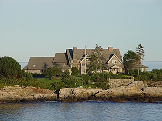
The Cape Arundel Summer Colony Historic District encompasses an enclave of large summer estates on the coast of Kennebunkport, Maine. The area was developed in the late 19th and early 20th century as a resort area for the wealthy of the northeastern United States. It notably includes the Kennebunk River Club and Walkers Point, the location of the Bush compound, which has a Shingle-style house built in 1903. The district was listed on the National Register of Historic Places in 1984.

The Kennebunk Historic District encompasses a large portion of the historic town center of Kennebunk, Maine. Established in 1736, the district includes a significant number of fairly high-style houses from the late 18th and early 19th centuries, when Kennebunk was at its height as a shipbuilding and maritime shipping center. The district was listed on the National Register of Historic Places in 1974.
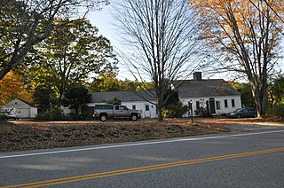
The James Smith Homestead is a historic house on 5 Russell Farm Road in Kennebunk, Maine. Built in 1753, it is one of the few surviving mid-18th century inland farmhouses in the town. It was listed on the National Register of Historic Places in 1982, and is included in the Lower Alewive Historic District.

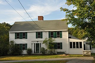
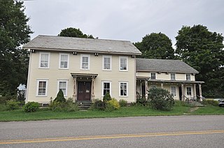
Wallingford Hall is a historic house at 21 York Street in Kennebunk, Maine. Built in 1805–06, it is an unusually grand expression of Federal architecture in the town, built by the regionally architect and builder Thomas Eaton, and one of the oldest surviving examples in the state of a connected farmstead. In the late 19th and early 20th century it was also home to William Barry, an architectural historian who wrote extensively on the architecture of southern Maine, and was an early promoter of the Colonial Revival in the area. The house was listed on the National Register of Historic Places in 2004.
Moody Farm is a historic farmstead at Lawry Road and Maine State Route 173 in Searsmont, Maine. The farmhouse was built about 1820 by Joseph Moody, one of the first settlers of the area after Maine gained statehood in 1820, and its barn is a mid-19th century double English barn. The property was listed on the National Register of Historic Places in 2002.
The Freeman Farm Historic District encompasses a historic farm property in Gray, Maine. The 100-acre (40 ha) parcel, originally platted out in 1791, was owned and operated by five generations of the Freeman family, and is emblematic of the changes in agricultural practices over a period of more than 150 years. It was listed on the National Register of Historic Places in 2003.
The Mortland Family Farm is a historic farmstead on Mortland Road in Searsport, Maine. Begun in 1834 and altered and enlarged until about 1950, it is a well-preserved example of a New England connected farmstead, a property type that has become increasingly rare in Maine. The farm, at 16.3 acres (6.6 ha) a fraction of its greatest extent, was listed on the National Register of Historic Places in 1991.
The Bradford Farm Historic District encompasses a historic farm property in Patten, Maine. Located on the west side of Maine State Route 11 on the north side of the village center, it includes a nearly-intact farm complex, with buildings dating from the 1840s to the 20th century. The property was listed on the National Register of Historic Places in 2003. The farmhouse is now the Bradford House Bed and Breakfast.

Top Acres Farm, known historically as the Fletcher–Fullerton Farm, is a farm property at 1390 Fletcher Schoolhouse Road in Woodstock, Vermont. Developed as a farm in the early 19th century, it was in continuous agricultural use by just two families for nearly two centuries. It was listed on the National Register of Historic Places in 2004.
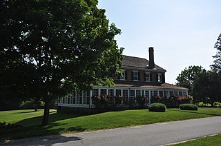
The Martin M. Bates Farmstead is a historic farm property on Huntington Road in Richmond, Vermont. Farmed since the 1790s, the property is now a well-preserved example of a mid-19th century dairy farm, with a fine Italianate farmhouse. The property was listed on the National Register of Historic Places in 1991.


