Lower Berkshire Valley, New Jersey

Last updated

Lower Berkshire Valley, New Jersey
79 Mill Road, Roxbury Township, NJ.jpg
Lafayette School, listed on the NRHP
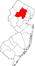
Location map of Morris County, New Jersey.svg
Red pog.svg
Lower Berkshire Valley
Location in Morris County
USA New Jersey relief location map.svg
Red pog.svg
Lower Berkshire Valley
Location in New Jersey
Usa edcp relief location map.png
Red pog.svg
Lower Berkshire Valley
Location in the United States
Coordinates: 40°54′49″N74°36′35″W / 40.91361°N 74.60972°W / 40.91361; -74.60972
CountryFlag of the United States.svg  United States
StateFlag of New Jersey.svg  New Jersey
County Morris
Townships Roxbury
Jefferson
Area
[1]
  Total1.03 sq mi (2.67 km2)
  Land1.01 sq mi (2.61 km2)
  Water0.02 sq mi (0.06 km2)
Elevation
702 ft (214 m)
Population
 (2020) [2]
  Total617
  Density611.50/sq mi (236.15/km2)
Time zone UTC−05:00 (Eastern (EST))
  Summer (DST) UTC−04:00 (EDT)
ZIP Code
07885 (Wharton)
Area code(s) 973/862
FIPS code 34-41700 [3]
GNIS feature ID2813401 [4]

Lower Berkshire Valley is a census-designated place (CDP) [5] in Roxbury and Jefferson townships, Morris County, New Jersey, in the United States. As of the 2020 census, it had a population of 617. [2]

Contents

Geography

The community is in western Morris County, primarily in the northeast part of Roxbury Township, along Berkshire Valley Road. The northernmost part of the CDP is in southern Jefferson Township. Interstate 80 passes through the southern part of the CDP, but with no direct access. The community is 2 miles (3 km) northwest of Wharton and 4 miles (6 km) northwest of Dover.

According to the U.S. Census Bureau, the Lower Berkshire Valley CDP has a total area of 1.03 square miles (2.67 km2), of which 0.02 square miles (0.05 km2), or 2.23%, are water. [1] The area is drained by the Rockaway River, which passes just east of the CDP boundary and flows east to the Passaic River at the Essex County border.

Demographics

The community was first listed as a CDP during the 2020 census. [4]

Historical population
CensusPop.Note
2020 617
U.S. Decennial Census [6] 2020 [2]

Related Research Articles

<span class="mw-page-title-main">Lake Telemark, New Jersey</span> Populated place in Morris County, New Jersey, US

Lake Telemark is an unincorporated community and census-designated place (CDP) in Rockaway Township, Morris County, New Jersey, United States. As of the 2020 census, the CDP's population was 1,172.

<span class="mw-page-title-main">Long Valley, New Jersey</span> Place in Morris County, New Jersey, United States

Long Valley is an unincorporated community and census-designated place (CDP) in Washington Township, Morris County, New Jersey, in the United States. Once known as German Valley from its foundation during the colonial era, the community was renamed in response to anti-German sentiment during World War I. As of the 2020 census, the CDP's population was 1,827.

<span class="mw-page-title-main">Roxbury, New Jersey</span> Township in Morris County, New Jersey, US

Roxbury is a township in southwestern Morris County, in the U.S. state of New Jersey. As of the 2020 United States census, the township's population was 22,950, a decrease of 374 (−1.6%) from the 2010 census count of 23,324, which in turn reflected a decline of 559 (−2.3%) from the 23,883 counted in the 2000 census. The township is located approximately 36 miles (58 km) west-northwest of New York City, 27 miles (43 km) west-northwest of Newark, New Jersey and 26 miles (42 km) east of the Delaware Water Gap on the border of New Jersey and Pennsylvania.

<span class="mw-page-title-main">Flanders, New Jersey</span> Populated place in Morris County, New Jersey, US

Flanders is an unincorporated community and census-designated place (CDP) in Mount Olive Township, in southwestern Morris County, New Jersey, United States. As of the 2020 census, the population was 9,832. Flanders is served by the U.S. Postal Service as ZIP Code 07836.

<span class="mw-page-title-main">Succasunna, New Jersey</span> Place in Morris County, New Jersey, United States

Succasunna is an unincorporated community and census-designated place (CDP) located within Roxbury Township, in Morris County, in the U.S. state of New Jersey, serving as its downtown and population center, having a population of 9,152 people as of the 2010 United States Census.

<span class="mw-page-title-main">Cedar Knolls, New Jersey</span> Populated place in Morris County, New Jersey, US

Cedar Knolls is an unincorporated community located within Hanover Township in Morris County, in the U.S. state of New Jersey. It is part of Hanover Township along with Whippany.

<span class="mw-page-title-main">Kenvil, New Jersey</span> Populated place in Morris County, New Jersey, US

Kenvil is an unincorporated community and census-designated place (CDP) located within Roxbury Township, in Morris County, in the U.S. state of New Jersey. As of the 2020 census, it had a population of 1,806.

<span class="mw-page-title-main">Ledgewood, New Jersey</span> Populated place in Morris County, New Jersey, US

Ledgewood is an unincorporated community and census-designated place (CDP) in Roxbury Township, Morris County, New Jersey, United States. It was historically known as Drakesville after Abraham Drake, originally from Piscataway, New Jersey, who operated a mill and tavern here in the mid 1700s. The community was located on the Morris Canal.

<span class="mw-page-title-main">Lake Hopatcong, New Jersey</span> Populated place in Morris County, New Jersey, US

Lake Hopatcong is a census-designated place (CDP) in Jefferson Township, Morris County, New Jersey, United States. It includes communities on the northeast side of Lake Hopatcong, the largest freshwater body in the state. As of the 2020 United States census, the population was 10,232.

Landing is an unincorporated community and census-designated place (CDP) in Roxbury Township, Morris County, New Jersey, United States. The community is located at the south end of Lake Hopatcong near Hopatcong State Park. The area is served as United States Postal Service ZIP Code 07850.

<span class="mw-page-title-main">Yardville, New Jersey</span> Populated place in Camden County, New Jersey, US

Yardville is an unincorporated community and census-designated place (CDP) in Hamilton Township, Mercer County, New Jersey, United States. As of the 2020 United States census, the CDP's population was 6,965. Before the 2010 census, the area was part of the Yardville-Groveville CDP.

<span class="mw-page-title-main">Gillette, New Jersey</span> Place in Morris County, New Jersey, United States

Gillette is an unincorporated community and census-designated place (CDP) in Long Hill Township, Morris County, New Jersey, United States. The area is served as United States Postal Service ZIP Code 07933. As of the 2020 United States census, the CDP had a population of 2,956.

<span class="mw-page-title-main">Port Murray, New Jersey</span> Census-designated place in Warren County, New Jersey, United States

Port Murray is an unincorporated community and census-designated place (CDP) located within Mansfield Township in Warren County, in the U.S. state of New Jersey, that was created as part of the 2010 United States Census. As of the 2010 Census, the CDP's population was 129.

Troy Hills is a census-designated place (CDP) in the township of Parsippany-Troy Hills, Morris County, in the U.S. state of New Jersey. It is in the southeast part of the township, bordered to the north and west by the Parsippany CDP, to the south by Whippany in Hanover Township, and to the east by Troy Meadows, the largest freshwater marsh in New Jersey.

<span class="mw-page-title-main">Port Colden, New Jersey</span> Populated place in Warren County, New Jersey, US

Port Colden is an unincorporated community and census-designated place (CDP) located within Washington Township, in Warren County, in the U.S. state of New Jersey, that was created as part of the 2010 United States Census. As of the 2010 Census, the CDP's population was 122.

<span class="mw-page-title-main">Robertsville, New Jersey</span> Populated place in Monmouth County, New Jersey, US

Robertsville is a census-designated place and unincorporated community in Marlboro Township, Monmouth County, in the U.S. state of New Jersey. As of the 2020 census, the CDP's population was 11,399.

<span class="mw-page-title-main">Washington Crossing, New Jersey</span> Populated place in Mercer County, New Jersey, US

Washington Crossing is an unincorporated community and census-designated place (CDP) in Hopewell Township, Mercer County, New Jersey, in the United States. The CDP and surrounding Hopewell Township lie on the eastern flank of the Washington Crossing Bridge spanning the Delaware River. Washington Crossing State Park is located adjacent to the community in New Jersey, while across the river lies Washington Crossing Historic Park in Washington Crossing, Pennsylvania. As of the 2020 United States census, the CDP's population was 371.

Regency at Monroe is a gated community and census-designated place (CDP) in Monroe Township, Middlesex County, New Jersey, United States. It was first listed as a CDP in the 2020 census, with a population of 2,036.

Stonebridge is a gated community and census-designated place (CDP) in Monroe Township, Middlesex County, in the U.S. state of New Jersey. As of the 2020 census, the year it was first listed as a CDP, the population was 1,616.

The Ponds is a planned community and census-designated place (CDP) in Monroe Township, Middlesex County, New Jersey, United States. As of the 2020 census, the year it was first listed as a CDP, the population was 941.

References

  1. 1 2 "2024 U.S. Gazetteer Files: New Jersey". United States Census Bureau. Retrieved October 29, 2024.
  2. 1 2 3 Census Data Explorer: Lyons CDP, New Jersey, United States Census Bureau. Accessed June 15, 2023.
  3. Geographic Codes Lookup for New Jersey, Missouri Census Data Center. Accessed June 9, 2023.
  4. 1 2 "Lower Berkshire Valley Census Designated Place". Geographic Names Information System . United States Geological Survey, United States Department of the Interior.
  5. State of New Jersey Census Designated Places - BVP20 - Data as of January 1, 2020, United States Census Bureau. Accessed December 1, 2022.
  6. "Census of Population and Housing". Census.gov. Retrieved June 4, 2016.