Lower Chanceford Township, Pennsylvania

Last updated

Lower Chanceford Township, Pennsylvania
Lower Channeled.jpg
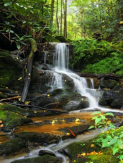
Oakland Run waterfalls as seen from the Mason-Dixon Trail
York County Pennsylvania incorporated and unincorporated areas Lower Chanceford township highlighted.svg
Location in York County and the state of Pennsylvania.
Country United States
State Pennsylvania
County York
Settled1734
Incorporated1805
Government
  TypeBoard of Supervisors
Area
[1]
  Total41.70 sq mi (108.00 km2)
  Land41.51 sq mi (107.50 km2)
  Water0.19 sq mi (0.50 km2)
Population
 (2020) [2]
  Total3,028
  Estimate 
(2021) [2]
3,040
  Density74.11/sq mi (28.61/km2)
Time zone UTC-5 (Eastern (EST))
  Summer (DST) UTC-4 (EDT)
Area code 717
FIPS code 42-133-44872
Website Township website
Historical population
CensusPop.Note
1850 1,637
1860 2,16031.9%
1870 2,3066.8%
1880 2,4717.2%
1890 2,5121.7%
1900 2,345−6.6%
1910 2,081−11.3%
1920 1,830−12.1%
1930 1,711−6.5%
1940 1,7301.1%
1950 1,582−8.6%
1990 2,454
2000 2,89918.1%
2010 3,0284.4%
2020 3,0280.0%
2021 (est.)3,040 [2] 0.4%
U.S. Decennial Census [3]

Lower Chanceford Township is a township in York County, Pennsylvania, United States. The population was 3,028 at the 2020 census. [2]

Contents

History

The Muddy Creek Bridge, Maryland and Pennsylvania Railroad, Indian Steps Cabin, and McCalls Ferry Farm are listed on the National Register of Historic Places. [4]

Geography

According to the United States Census Bureau, the township has a total area of 41.7 square miles (108 km2), of which 41.6 square miles (108 km2) is land and 0.1 square miles (0.26 km2), or 0.34%, is water.

Demographics

As of the census [5] of 2000, there were 2,899 people, 1,028 households, and 793 families living in the township. The population density was 69.7 inhabitants per square mile (26.9/km2). There were 1,169 housing units at an average density of 28.1 per square mile (10.8/km2). The racial makeup of the township was 97.93% White, 0.41% African American, 0.34% Native American, 0.55% Asian, 0.07% Pacific Islander, 0.31% from other races, and 0.38% from two or more races. Hispanic or Latino of any race were 0.41% of the population.

There were 1,028 households, out of which 38.4% had children under the age of 18 living with them, 65.9% were married couples living together, 6.5% had a female householder with no husband present, and 22.8% were non-families. 19.3% of all households were made up of individuals, and 6.8% had someone living alone who was 65 years of age or older. The average household size was 2.82 and the average family size was 3.24.

In the township the population was spread out, with 30.0% under the age of 18, 7.4% from 18 to 24, 31.0% from 25 to 44, 22.3% from 45 to 64, and 9.2% who were 65 years of age or older. The median age was 35 years. For every 100 females, there were 104.4 males. For every 100 females age 18 and over, there were 103.0 males.

The median income for a household in the township was $43,081, and the median income for a family was $48,063. Males had a median income of $37,042 versus $21,890 for females. The per capita income for the township was $17,821. About 5.4% of families and 7.6% of the population were below the poverty line, including 12.0% of those under age 18 and 9.1% of those age 65 or over.

Notable people

Related Research Articles

Fremont Township is a civil township of Tuscola County in the U.S. state of Michigan. The population was 3,167 at the 2020 census.

<span class="mw-page-title-main">Herrick Township, Bradford County, Pennsylvania</span> Township in Pennsylvania, United States

Herrick Township is a township in Bradford County, Pennsylvania, United States. It is part of Northeastern Pennsylvania. The population was 754 at the 2010 census. For years it was known for a chair sitting on a fence post as you entered the town from the south on route 1017.

<span class="mw-page-title-main">Jackson Township, Cambria County, Pennsylvania</span> Township in Pennsylvania, United States

Jackson Township is an American township which is located in Cambria County, Pennsylvania. The population was 4,392 at the time of the 2010 census, down from 4,925 at the 2000 census.

West Goshen was a census-designated place (CDP) in West Goshen Township, Chester County, Pennsylvania, United States. The population was 8,472 at the 2000 census. The CDP was not delineated for the 2010 census.

<span class="mw-page-title-main">Rockdale Township, Pennsylvania</span> Township in Pennsylvania, United States

Rockdale Township is a township in Crawford County, Pennsylvania, United States. The population was 1,363 at the 2020 census, down from 1,506 at the 2010 census.

<span class="mw-page-title-main">Spring Township, Crawford County, Pennsylvania</span> Township in Pennsylvania, United States

Spring Township is a township in Crawford County, Pennsylvania, United States. The population was 1,407 at the 2020 census, down from 1,548 at the 2010 census.

<span class="mw-page-title-main">Woodcock Township, Pennsylvania</span> Township in Pennsylvania, United States

Woodcock Township is a township in Crawford County, Pennsylvania, United States. The population was 2,756 at the 2020 census, down from 2,856 at the 2010 census.

<span class="mw-page-title-main">Girard Township, Erie County, Pennsylvania</span> Township in Pennsylvania, United States

Girard Township is a township in Erie County, Pennsylvania, United States. The population was 4,872 at the 2020 census, down from the population of 5,102 at the 2010 census.

<span class="mw-page-title-main">Georges Township, Pennsylvania</span> Township in Pennsylvania, United States

Georges Township is a township in Fayette County, Pennsylvania, United States. The population was 6,346 at the 2020 census, a decline from the figure of 6,612 tabulated in 2010. It is served by the Albert Gallatin Area School District.

<span class="mw-page-title-main">Henry Clay Township, Fayette County, Pennsylvania</span> Township in Pennsylvania, United States

Henry Clay Township is a township in Fayette County, Pennsylvania, United States. The population was 1,764 at the 2020 census. The township was created June 9, 1824, from the eastern portion of Wharton Township. It is named for 19th-century American statesman Henry Clay. The northwestern corner of its territory was used to create Stewart Township on November 17, 1855. It is served by the Uniontown Area School District.

<span class="mw-page-title-main">Strasburg Township, Pennsylvania</span> Township in Pennsylvania, United States

Strasburg Township is a township in south central Lancaster County, Pennsylvania, United States. The population was 4,467 at the 2020 census.

<span class="mw-page-title-main">Hamilton Township, McKean County, Pennsylvania</span> Township in Pennsylvania, United States

Hamilton Township is a township in McKean County, Pennsylvania, United States. The population was 553 at the 2020 census.

<span class="mw-page-title-main">Harrison Township, Potter County, Pennsylvania</span> Township in Pennsylvania, United States

Harrison Township is a township in Potter County, Pennsylvania, United States. The population was 1,028 at the 2020 census.

<span class="mw-page-title-main">West Mahanoy Township, Pennsylvania</span> Township in Pennsylvania, United States

West Mahanoy Township is a township that is located in Schuylkill County, Pennsylvania. The population was 2,786 at the time of the 2020 census.

<span class="mw-page-title-main">Lower Turkeyfoot Township, Pennsylvania</span> Township in Pennsylvania, United States

Lower Turkeyfoot Township is a township in Somerset County, Pennsylvania, United States. The population was 543 at the 2020 census. It is part of the Johnstown, Pennsylvania, Metropolitan Statistical Area.

<span class="mw-page-title-main">Osceola Township, Pennsylvania</span> Township in Pennsylvania, United States

Osceola Township is a township in Tioga County, Pennsylvania, United States. The population was 586 at the 2020 census.

<span class="mw-page-title-main">Codorus Township, Pennsylvania</span> Township in Pennsylvania, United States

Codorus Township is a township in York County, Pennsylvania, United States. The population was 3,898 at the 2020 census.

<span class="mw-page-title-main">East Hopewell Township, Pennsylvania</span> Township in Pennsylvania, United States

East Hopewell Township is a township in York County, Pennsylvania, United States. The population was 2,416 at the 2020 census. It is served by the South Eastern School District which provides a public education.

<span class="mw-page-title-main">Springfield Township, York County, Pennsylvania</span> Township in Pennsylvania, United States

Springfield Township is a township in York County, Pennsylvania, United States. The population was 6,023 at the 2020 census.

<span class="mw-page-title-main">York Township, Pennsylvania</span> Township in Pennsylvania, United States

York Township is a township in York County, Pennsylvania, United States. The township is a suburb of The City of York. The population was 29,737 at the 2020 census.

References

  1. "2016 U.S. Gazetteer Files". United States Census Bureau. Retrieved August 14, 2017.
  2. 1 2 3 4 Bureau, US Census. "City and Town Population Totals: 2020-2021". Census.gov. US Census Bureau. Retrieved July 8, 2022.
  3. "Census of Population and Housing". Census.gov. Retrieved June 4, 2016.
  4. "National Register Information System". National Register of Historic Places . National Park Service. July 9, 2010.
  5. "U.S. Census website". United States Census Bureau . Retrieved January 31, 2008.
  6. "Joseph T. Grove". The Baltimore Sun . January 2, 1892. p. 3. Retrieved October 11, 2023 via Newspapers.com. Open Access logo PLoS transparent.svg

39°48′00″N76°20′59″W / 39.80000°N 76.34972°W / 39.80000; -76.34972