Lower Moors (St Mary's)

Last updated

Lower Moors (St Mary's)
Site of Special Scientific Interest
Lower Moor Wetland, St. Mary's - geograph.org.uk - 931546.jpg
The wetlands of Lower Moors
Isles of Scilly UK location map.svg
Red pog.svg
Location within Isles of Scilly
Location Cornwall
Grid reference SV912106
Coordinates 49°54′59″N6°18′09″W / 49.9164°N 6.3025°W / 49.9164; -6.3025 Coordinates: 49°54′59″N6°18′09″W / 49.9164°N 6.3025°W / 49.9164; -6.3025
InterestBiological
Area10.2 hectares (0.10 km2; 0.039 sq mi)
Notification 1971 (1971)
Natural England website

The Lower Moors is a wetland between Hugh Town and Old Town Bay on St Mary's, the largest island in the Isles of Scilly. [1] The Isles of Scilly are an archipelago off the southwestern tip of the Cornish peninsula of Great Britain.

Contents

The site is owned and managed by the Isles of Scilly Wildlife Trust and is within the Isles of Scilly Area of Outstanding Natural Beauty. First designated as a Site of Special Scientific Interest (SSSI) in 1971 for its range of wetland habitats; it is an important feeding station for migrating and wintering birds such as common snipe and water rail. [2] In 2007 Cavell Smith found a great blue heron; the first confirmed record for Britain. The second British record for great blue heron also occurred on Lower Moor and, was also found by Cavell Smith. [3]

Wildlife and ecology

Reed beds in the Lower Moors reserve Reed Beds, Lower Moors, St. Mary's - geograph.org.uk - 931543.jpg
Reed beds in the Lower Moors reserve

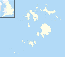
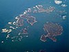
Lower Moors is one of two wetlands on St Mary's and is designated as a SSSI for its wide range of wetland habitats, and also as a feeding site for passage and wintering birds. The marsh is fed by ground water and small streams forming small open pools, mire and willow scrub, and the marsh once extended from Old Town Bay to Porthloo Pool . [4] As late as the 1960s there were wet fields around Porthloo Pool and Rose Hill with hemlock water-dropwort ( Oenanthe crocata ), lesser water-plantain ( Baldellia ranunculoides ) and yellow iris ( Iris pseudacorus ); but these fields are much dryer nowadays. [5] Lesser water-plantain has not been seen on the Isles of Scilly since the year 2000. [6] The site can be entered via a short lane at Old Town, the original medieval settlement on St Mary's, or from the A3111 near Porth Mellon. [1] [4] The soils are wet, alluvium and peat overlying Hercynian granite bedrock. [2] Since grazing was withdrawn some of the marsh is overgrown with abundant common reed ( Phragmites australis ), rushes ( Juncus spp.) and grey willow ( Salix cinerea ). The drainage ditches, flow southward to Old Town Bay and divide the marsh into wet meadows with abundant soft rush ( Juncus effusus ), yellow iris and some ragged robin ( Lychnis flos-cuculi ) and greater bird's-foot trefoil ( Lotus pedunculatus ). Bramble ( Rubus fruticosus ) and bracken ( Pteridium aquilinum ) dominate the drier areas. [7]

Lower Moors is a vital feeding area for resident birds, such as Eurasian coot, gadwall, mallard, common moorhen, Eurasian teal and various warblers. [4] The small area of open water is important for passage snipe and water rail, while the reed beds and wet meadows are used by birds such as corncrake and spotted crake. [2]

The first records of the short-winged cone-head was on St Agnes in 1989, confirmed in 1992 and found on Lower Moors in 1996. The eggs can be carried on vegetation as sea flotsam so it could have been established on Scilly earlier than 1989.

Great blue heron

To most bird watchers the Isles of Scilly are associated with rare birds, migrants and vagrants. [5] The first accepted record of a great blue heron in Britain was recorded on 7 December 2007, by Cavell Smith at Lower Moors, and subsequently added to the British List of birds by the British Ornithologists' Union Records Committee (BOURC). On 14 April 2015, Cavell Smith observed two herons from the bird-hide on Lower Moor, one was a grey heron and the other a great blue heron; the second British record (if accepted by the (BOURC)). It had since been seen at Old Town Bay, on Tresco and on Bryher. [8] Two previous records of the bird in Britain had had assisted passages aboard ships. [9]

See also

Related Research Articles

<span class="mw-page-title-main">St Mary's, Isles of Scilly</span> Human settlement in England

St Mary's is the largest and most populous island of the Isles of Scilly, an archipelago off the southwest coast of Cornwall in England.

<span class="mw-page-title-main">Cotswold Water Park</span>

The Cotswold Water Park is the United Kingdom's largest marl lake system, straddling the Wiltshire–Gloucestershire border, northwest of Cricklade and south of Cirencester. There are 180 lakes, spread over 42 square miles (110 km2).

<span class="mw-page-title-main">Reed bed</span> Habitats formed by reed colonies in floodplains and estuaries

A reedbed or reed bed is a natural habitat found in floodplains, waterlogged depressions and estuaries. Reedbeds are part of a succession from young reeds colonising open water or wet ground through a gradation of increasingly dry ground. As reedbeds age, they build up a considerable litter layer that eventually rises above the water level and that ultimately provides opportunities in the form of new areas for larger terrestrial plants such as shrubs and trees to colonise.

<span class="mw-page-title-main">St Agnes, Isles of Scilly</span> Island in the Isles of Scilly, UK

St Agnes is the southernmost populated island of the Isles of Scilly. Thus the island's Troy Town Farm is the southernmost settlement in the United Kingdom.

<span class="mw-page-title-main">Bryher</span> Human settlement in England

Bryher is one of the smallest inhabited islands of the Isles of Scilly, with a population of 84 in 2011, spread across 134 hectares (1.34 km2).

<span class="mw-page-title-main">Annet, Isles of Scilly</span>

Annet is the second largest of the fifty or so uninhabited Isles of Scilly, 1 kilometre (0.62 mi) west of St Agnes with a length of 1 kilometre (0.62 mi) and approximately 22 hectares in area. The low-lying island is almost divided in two by a narrow neck of land at West Porth which can, at times, be covered by waves. At the northern end of the island are the two granite carns of Annet Head and Carn Irish and three smaller carns known as the Haycocks. The rocky outcrops on the southern side of the island, such as South Carn, are smaller. Annet is a bird sanctuary and the main seabird breeding site in Scilly.

<span class="mw-page-title-main">St Helen's, Isles of Scilly</span>

St Helen's is one of the fifty or so uninhabited islands in the archipelago of the Isles of Scilly and has an approximate area of 0.1885 square kilometres. On the south side of the island is one of the earliest Christian sites in Scilly, an early medieval religious complex, which is thought to be the remains of St Elidius Hermitage, an 8th-century chapel lived in by Saint Lide,. There are also the remains of an isolation hospital used to quarantine sailors with plague. The island is the major part of a Site of Special Scientific Interest and some features have been given the designation of scheduled ancient monument. Access to the island is through chartered or private boat, although there are some season trips throughout the summer. St Helen's is currently managed by the Isles of Scilly Wildlife Trust.

<span class="mw-page-title-main">Teän</span>

Teän is an uninhabited island to the north of the Isles of Scilly archipelago between Tresco, 1.5 kilometres (0.9 mi) to the west, and St Martin's, 300 metres (330 yd) to the east. Approximately 16 hectares in area, the island consists of a series of granite tors with the highest point, Great Hill, rising to 40 metres (130 ft) at its eastern end. The low-lying land is overlain with glacial till and outwash gravels with glacial erratics abundant on the north coast beaches, which indicates the southern limit of outwash from an ice sheet for which it is designated a Geological Conservation Review site.

<span class="mw-page-title-main">White Island, Isles of Scilly</span> Island of Great Britain

White Island is one of the larger unpopulated islands of the Isles of Scilly, part of the United Kingdom, and lies off the coast of the northernmost populated island of the group, St Martin's, to which it is joined by a tidal causeway, or isthmus. The island is designated as a Site of Special Scientific Interest (SSSI) and a Geological Conservation Review site and is managed by the Isles of Scilly Wildlife Trust on behalf of the Duchy of Cornwall.

<span class="mw-page-title-main">Treen Cliff</span> Site of Special Scientific Interest on the Penwith Peninsula in Cornwall, England

Treen Cliff is a Site of Special Scientific Interest (SSSI) located on the Penwith Peninsula in Cornwall, England, UK, 6 miles (9.7 km) south-west of Penzance. First notified in 1951, with a revision in 1973, and a further notification on 1 July 1986, it is 49.3 hectares in area, stretching from grid reference SW387220 to SW402225. Designated for both for its biological and geological interest, part of the site, Treryn Dinas, is a Scheduled Ancient Monument consisting of a "cliff castle" with four ramparts and ditches and the Logan Rock. It is within the Cornwall Area of Outstanding Natural Beauty (AONB), the Penwith Heritage Coast and is part owned and managed by the National Trust.

The year 2007 in birding and ornithology.

The years 1980–1989 in birding and ornithology.

<span class="mw-page-title-main">Wingletang Down (St Agnes)</span>

Wingletang Down is a Site of Special Scientific Interest (SSSI) on the southern side of the island of St Agnes in the Isles of Scilly, England, UK, which is noted for its biological characteristics. The site is managed by the Isles of Scilly Wildlife Trust and is within the Isles of Scilly Heritage Coast and the Isles of Scilly Area of Outstanding Natural Beauty. It is the only site in Great Britain and Ireland for the small fern, least adder's–tongue. As of 11 September 2009 the SSSI was considered to be in ″unconditional recovering″ condition because European gorse and bramble are at unacceptable levels.

<span class="mw-page-title-main">Eastern Isles</span>

The Eastern Isles are a group of twelve small uninhabited islands within the Isles of Scilly Area of Outstanding Natural Beauty, part of the Scilly Heritage Coast and a Site of Special Scientific Interest (SSSI) first designated in 1971 for its flora and fauna. They have a long period of occupation from the Bronze Age with cairns and entrance graves through to Iron Age field systems and a Roman shrine on Nornour. Before the 19th century, the islands were known by their Cornish name, which had also become the name of the largest island in the group after the submergence of the connecting lands.

<span class="mw-page-title-main">Porth Hellick</span> Human settlement in England

Porth Hellick is a tidal inlet on the south coast of St Mary’s, the largest island in the Isles of Scilly.

Castle Down is a windswept plateau of maritime heath in the northern part of the island of Tresco, Isles of Scilly. The area has a number of designations including Castle Down (Tresco) Site of Special Scientific Interest (SSSI); is part of the Isles of Scilly Area of Outstanding Natural Beauty; part of the Isles of Scilly Heritage Coast; and part of Plantlife's Isles of Scilly Important Plant Area. There are a number of Schedule Ancient Monument's ranging in age from Bronze Age cairns to castles built in the 16th and 17th centuries to protect the anchorage of New Grimsby harbour.

<span class="mw-page-title-main">Chyenhal Moor</span> Site of Special Interest in Cornwall

Chyenhal Moor is a poorly drained shallow valley, 2 miles (3.2 km) to the south-west of Penzance, Cornwall. Due to several rare plants in a diverse range of habitats, it was notified as a Site of Special Scientific Interest (SSSI) in 1951.

Ron Ward's Meadow With Tadley Pastures is a site of Site of Special Scientific Interest (SSSI). It is based on the edge of Tadley in Hampshire, England. It is managed by the Hampshire and Isle of Wight Wildlife Trust.

<span class="mw-page-title-main">Farnham Mires</span> Site of Special Scientific Interest in North Yorkshire, England

Farnham Mires is a Site of Special Scientific Interest, or SSSI, to the east of the village of Farnham, North Yorkshire, England. It consists of a spring-fed marshy fen or mire with reeds and sedge, and drier calcareous grassland containing a diverse range of flora. It has a history of poaching and fox hunting, but since the late 19th century, the attention of botanists has been drawn to its large variety of flowering plants. It has received some consideration on this account since 1944, and from 1954 it was designated SSSI status. This site has no facilities, and is not open to the public.

References

  1. 1 2 Ordnance Survey: Landranger map sheet 203 Land's End ISBN   978-0-319-23148-7
  2. 1 2 3 "Lower Moors (St Mary's)" (PDF). Natural England . Retrieved 18 April 2015.
  3. "Review of the week 8–14 April". BirdGuides. Retrieved 19 April 2015.
  4. 1 2 3 Cooper, Andrew (2009). Secret Nature of the Isles of Scilly. Dartington: Green Books. ISBN   978 1 903998 51 9.
  5. 1 2 Parslow, Rosemary (2007). The Isles of Scilly. London: HarperCollins. ISBN   978-0-00-220151-3.
  6. Bennallick, Ian J; French, Colin N; Parslow, Rosemary E (2009). Vascular Plants. In CISFBR Red Data Book for Cornwall and the Isles of Scilly (2nd ed.). Praze-an-Beeble: Croceago Press. pp. 105–157. ISBN   978 1901685 01 5.
  7. Louseley, J E (1971). Flora of the Isles of Scilly. Newton Abbot: David & Charles. ISBN   0 7153 5465 5.
  8. "Isles of Scilly Bird Group" . Retrieved 18 April 2015.
  9. "BOURC/BBRC Great Blue Heron admitted to the British List". BirdGuides. Retrieved 18 April 2015.