
Horseshoe Lake is a town in Crittenden County, Arkansas, United States. The population was 292 at the 2010 census.

The City of Fort Lupton is a Statutory City located in Weld County, Colorado, United States. Fort Lupton is a part of the Greeley, CO Metropolitan Statistical Area. The population was 7,377 as of the 2010 census.

The Tel Aviv District is the smallest and most densely populated of six administrative districts of Israel with a population of 1.35 million residents. It is 98.9% Jewish and 1.10% Arab.

Folkestone and Hythe is a constituency represented in the House of Commons of the UK Parliament since 2010 by Damian Collins, a Conservative.

Busia is a county in the former Western Province of Kenya. It borders Kakamega County to the east, Bungoma County to the north, Lake Victoria and Siaya County to the south and Busia District, Uganda to the west. The county has about 893,000 people and spans about 1,700 square kilometers making it one of the smallest counties in Kenya. Busia is inhabited by the Luhya tribe of Kenya with smaller groups of Teso and Luo. The Luhya communities include the Abakhayo, Marachi, Samia and Abanyala communities.
Nkhotakota is a district in the Central Region of Malawi. The capital is Nkhotakota. The district covers an area of 4,259 km² and has a population of 395,897. The word Nkhotakota means "zig-zag" in Chichewa. It is located along the shore of Lake Malawi.
Laikipia County is one of the 47 counties of Kenya, located on the Equator in the former Rift Valley Province of the country. Laikipia is a cosmopolitan county and is county number 31. The county has two major urban centres: Nanyuki to the southeast, and Nyahururu to the southwest. Its capital is Rumuruti. The County lies between latitudes 0° 18” South and 0° 51” North and between longitude 36° 11” and 37° 24’ East. It borders Samburu County to the North, Isiolo County to the North East, Meru County to the East, Nyeri County to the South East, Nyandarua County to the South, Nakuru County to the South West and Baringo County to the West.

Kakamega County is a county in the former Western Province of Kenya and borders Vihiga County to the South, Siaya County to the West, Bungoma and Trans Nzoia Counties to the North and Nandi and Uasin Gishu Counties to the East. CIDP Its capital and largest town is Kakamega. It has a population of 1,867,579 and an area of 3,033.8 km2.
Gucha District was a former district in Nyanza Province, western Kenya. It was also known by the name: South Kisii District or Ogembo District. In 1999, its population was approximately 461,000. Its district headquarters were at Ogembo which houses more than a thousand residents,, with more than one thousand people more that visit it each day.

Siaya County is one of the counties in the former Nyanza Province in the southwest part of Kenya. It is bordered by Busia County to the north, Kakamega County and Vihiga County's to the northeast and Kisumu County to the southeast. It shares a water border with Homa Bay County which is located south of Siaya County. The total area of the county is approximately 2,496.1 km2. The county lies between latitude 0° 26’ to 0° 18’ north and longitude 33° 58’ east and 34° 33’ west. Siaya has been split up into six new districts. Under the Constitution 2010, the role of districts are still unclear as much of administrative authority is being transferred to the county. The capital is Siaya, even though the largest town is Bondo.
Bridlington was a constituency in East Yorkshire, represented in the House of Commons of the Parliament of the United Kingdom from 1950 until it was abolished for the 1997 general election. It was named after the town of Bridlington.
Butere/Mumias District was an administrative district in the Western Province of Kenya. Its capital town was Butere. The district had a population of 476,928 and an area of 939 km². In 2010, the district was eliminated and incorporated into Kakamega County.

Vihiga County is an administrative region in the former Western Province of Kenya whose headquarters are in Mbale, the largest town in the county. The county has a population of 554,622 and an area of 563 km2. Vihiga County was split from Kakamega County in 1990. In 2019's census, Vihiga was found to have a population of 590, 013, an increase of 35, 391 from the 2009's count.
Mount Elgon District was an administrative district in the Western Province of Kenya. Its capital town was Kapsokwony. In 2010, it was merged into Bungoma County.

Arfon is a constituency of the Senedd. It was created for the former Assembly's 2007 election. It elects one Member of the Senedd by the first past the post method of election. Also, however, it is one of nine constituencies in the North Wales electoral region, which elects four additional members, in addition to nine constituency members, to produce a degree of proportional representation for the region as a whole.

Lugari is a town in Kakamega County in the former Western Province of Kenya. Until 2010, it was the capital of the former Lugari District. The town is located 10 kilometres east of Webuye. Lugari has an urban population of 5000 Lugari has two constituencies: likuyani under honourable enoch Kibunguchi and Lugari under honourable Ayub Savula.(1999 census ).
Cyrus Shakhalaga Khwa Jirongo, popularly Cyrus Jirongo, is a politician and a former Member of Parliament in Kenya. Between 1978 and 1981 he went to Mang'u High School. He became the chairman of AFC Leopards football club in 1991.
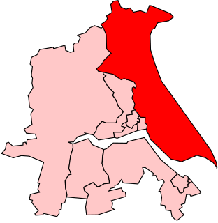
Lugari Constituency is an electoral constituency in Kenya. It is one of twelve constituencies in Kakamega County, and the only constituency in the former Lugari District. The entire constituency has eight wards, all of which elect councillors for the Lugari County Council. The constituency was established for the 1988 elections.

Katlang is a tehsil in the Mardan District of the Khyber Pakhtunkhwa, Pakistan. It is located approximately 19 kilometers north of Mardan. The population of Katlang was 343,144 in 2017.

Sub-counties are the decentralised units through which county governments of Kenya will provide functions and services. Except for the parts which fall under urban areas, sub-counties will coincide with the constituencies created under article 89 of the Constitution of Kenya. Sub-counties will be headed by a sub-county administrator, appointed by a County Public Service Board.